2856 entries match your criteria. Entries 101 through 200 are listed.⊲ Previous 100 — Next 100 ⊳
Anthropology & Archaeology Topic
By Thomas Smith, August 28, 2023
Northeast Arkansas Discovery Tour Marker
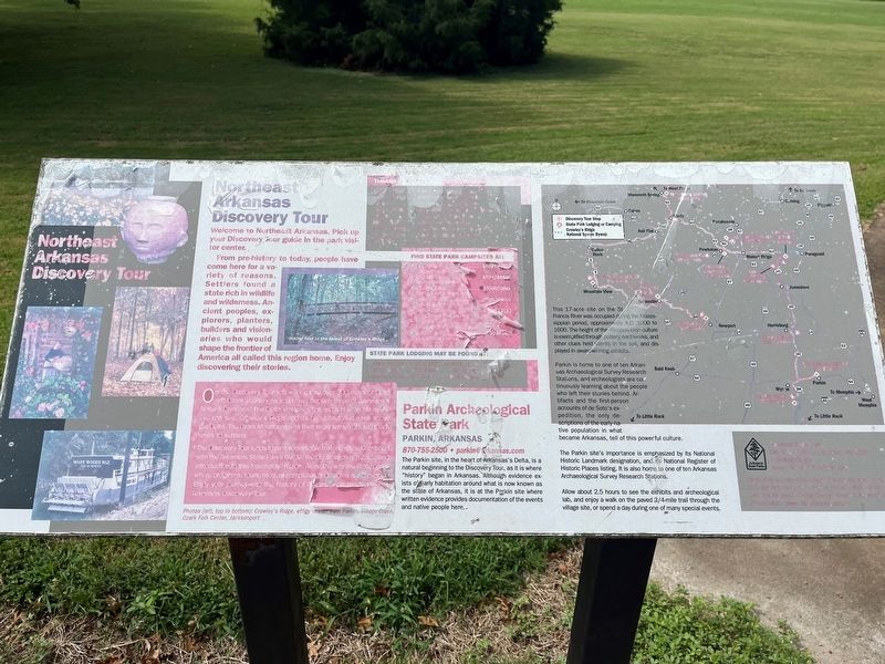
| 101 ► Arkansas, Cross County, Parkin — Northeast Arkansas Discovery Tour — |
| On State Highway 184 at U.S. 64 on State Highway 184. | |||
| 102 ► Arkansas, Cross County, Parkin — Protecting Casqui's Capital — |
| On State Highway 184, 0.2 miles north of U.S.64, on the left when traveling north. | |||
| 103 ► Arkansas, Cross County, Parkin — The Sawdust Hill Community — |
| On State Highway 184, 0.2 miles U.S. 64, on the left when traveling north. | |||
| 104 ► Arkansas, Cross County, Parkin — Welcome to the Village Trail — |
| On Ark. State Hwy 184, 0.1 miles Us Hwy 64, on the left. | |||
| 105 ► Arkansas, Lonoke County, Scott — Home to Some; Capitol City to All — Toltec Mounds Archeological State Park — |
| On Toltec Mounds Rd, 1 mile south of Ar. Rd 165 (State Road 165), on the right. | |||
| 106 ► Arkansas, Lonoke County, Scott — Plants Tell a Human Story — |
| On Toltec Mounds Road, 1 mile Ar. Rd 165 (State Road 165), on the right when traveling south. | |||
| 107 ► Arkansas, Montgomery County, Norman — Archeological Analysis of Norman Caddo Indian Burial Ground — Site Map of Norman Indian Burial Ground — prepared by Mary Beth Trubitt Arkansas Archeological Survey Henderson Research Station — |
| On East Main Street south of Polk Creek Road, on the left when traveling north. | |||
| 108 ► Arkansas, Pulaski County, Scott — Not For Human Consumption — |
| On Toltec Mounds Road, on the right when traveling south. | |||
| 109 ► Arkansas, Randolph County, Black Rock — Archeology Uncovers the Past — Davidsonville Historic State Park — |
| Near Arkansas Route 166, 0.6 miles south of Arkansas Route 361 when traveling south. | |||
| 110 ► Arkansas, Randolph County, Black Rock — Davidsonville Town Site — 1815 - 1830 — Davidsonville Historic State Park — |
| Near Arkansas Route 166 south of Arkansas Route 361 when traveling south. | |||
| 111 ► Arkansas, Randolph County, Pocahontas — Native American Culture — |
| On U.S. 62/67 north of South Bettis Street, on the right when traveling north. | |||
| 112 ► Arkansas, Sebastian County, Fort Smith — Who Served Here? — Fort Smith National Historic Site — National Park Service, U.S. Department of the Interior — |
| Near Parker Avenue at South 3rd Street. | |||
| 113 ► California, Alameda County, Fremont, Cameron Hills — In Search of Fossils — |
| Near Via Orinda near Castillejo Way. | |||
| 114 ► California, Alameda County, Fremont, Cameron Hills — Land Mammals of the Irvingtonian Age — |
| Near Via Orinda near Castillejo Way. | |||
| 115 ► California, Alameda County, Fremont, Cameron Hills — Sabercat Historical Park — City of Fremont — Via Orinda Entrance — |
| On Via Orinda at Castillejo Way, on the right when traveling east on Via Orinda. | |||
| 116 ► California, Alameda County, Fremont, Niles — California Nursery Historical Park — |
| Near Nursery Avenue near Niles Avenue. | |||
| 117 ► California, Alameda County, Fremont, Vineyards - Avalon — The Ohlones and the Mission San Jose — Rancho Higuera Historical Park — |
| On Rancho Higuera Road south of Curtner Road, on the left when traveling south. | |||
| 118 ► California, Alameda County, Livermore — A Natural Supermarket and Hardware Store — Sycamore Grove Park — |
| 119 ► California, Alameda County, Livermore — Brushy Peak Regional Preserve — |
| On West Side Loop Trail west of Laughlin Road, on the right when traveling west. | |||
| 120 ► California, Alameda County, Livermore — Brushy Peak Regional Preserve — |
| Near Laughlin Ranch Loop south of Laughlin Road, on the right when traveling south. | |||
| 121 ► California, Butte County, Oroville — Native Food Preparation — |
| Near Bryant Ravine Road (Forest Road 21N35Y) 1.6 miles north of Lumpkin Road when traveling north. | |||
| 122 ► California, Contra Costa County, Danville — Tatcan Bay Miwok Indians — |
| Near Front Street south of Diablo Road. | |||
| 123 ► California, Contra Costa County, Danville — Turritella Snail Bed — Fossil Snails Tell Their Story in These Rocks — |
| Near Wall Point Road, on the left when traveling south. | |||
| 124 ► California, Contra Costa County, San Ramon — First People of the East Bay — |
| Near San Ramon Valley Boulevard south of Pine Valley Road, on the right when traveling south. | |||
| 125 ► California, El Dorado County, Coloma — Sutter Mill Timbers — |
| Near State Highway 49 north of Mt Murphy Road. | |||
| 126 ► California, El Dorado County, Coloma — Uncovering History — |
| Near Coloma Road (California Route 49) north of Mt Murphy Road. | |||
| 127 ► California, Humboldt County, Orick — Madison Grant Forest and Elk Refuge — Dedicated to the Memory of Madison Grant — 1865-1937 — |
| On Newton B. Drury Scenic Parkway, on the left when traveling north. | |||
| 128 ► California, Imperial County, Ocotillo — Geoglyphs — Imperial Valley Desert Museum — Español: Geoglifos — Kumeyaay: Matt Uumall — |
| On Frontage Road, 0.3 miles west of Imperial Highway, on the left when traveling west. | |||
| 129 ► California, Imperial County, Ocotillo — Imperial Valley Desert Museum — Jay C. von Werlhof — |
| Near Frontage Road, 0.3 miles west of Imperial Highway. | |||
| 130 ► California, Imperial County, Seeley — Rock Art — California and Baja California Rock Art — |
| Near Kumeyaay Highway (Interstate 8) 3 miles west of Forester Road (County Road S30), on the right when traveling east. | |||
| 131 ► California, Inyo County, Ridgecrest — Coso Rock Art District — Big and Little Petroglyph Canyon — National Historic Landmark — |
| Near China Lake Boulevard. | |||
| 132 ► California, Kern County, Tehachapi — 1054 — Tomo-Kahni — |
| Near Basalt Road, 1 mile south of Tranquility Road. | |||
| 133 ► California, Lassen County, Westwood — Paul Bunyan — The Legend Lives On — |
| On 3rd Street (County Highway A21) east of Birch Street, on the right when traveling east. | |||
| 134 ► California, Los Angeles County, Long Beach, Waterfront — Easter Island Moai — |
| On Aquarium Way just south of Shoreline Drive. | |||
| 135 ► California, Los Angeles County, Los Angeles, Brentwood — Hammat Tiberias — Skirball Museum — |
| Near Sepulveda Boulevard at Skirball Center Drive, on the left when traveling north. | |||
| 136 ► California, Los Angeles County, Los Angeles, Chinatown — 5 — Zanja Madre — “Mother Ditch and the History Slugs” — Los Angeles State Historic Park — |
| On Spring Street at Sotello Street, on the left when traveling north on Spring Street. | |||
| 137 ► California, Los Angeles County, Los Angeles, Downtown Los Angeles — El Aliso — Kizh-Gabrieleño Sacred Sycamore Tree — Sha’var — |
| On Commercial Street at Vignes Street, on the left when traveling east on Commercial Street. | |||
| 138 ► California, Los Angeles County, Los Angeles, Hollywood — 112 — A Gabrielino Indian Site — Ferndell Canyon — |
| On Fern Dell Drive at Black Oak Drive, on the left when traveling north on Fern Dell Drive. | |||
| 139 ► California, Los Angeles County, Los Angeles, Mount Washington — 283 — Southwest Museum — |
| Near Museum Drive at Marmion Way. | |||
| 140 ► California, Los Angeles County, Los Angeles, South Los Angeles — 36 — Egyptian Obelisk — |
| On 103rd Street at Graham Avenue, on the right when traveling east on 103rd Street. | |||
| 141 ► California, Los Angeles County, Los Angeles, South Los Angeles — Maya Obelisk — |
| On Santa Ana Boulevard North at Wilmington Avenue, on the right when traveling east on Santa Ana Boulevard North. | |||
| 142 ► California, Marin County, Novato — Cook House — |
| Near Redwood Highway. | |||
| 143 ► California, Marin County, San Anselmo — Indiana Jones — |
| On San Anselmo Avenue. | |||
| 144 ► California, Marin County, Tiburon — First Occupants of the Cove — |
| 145 ► California, Mendocino County, Cleone — Harvesting the Shore — |
| Near Mill Creek Drive near California Route 1. | |||
| 146 ► California, Monterey County, Big Sur — Esselen: We Are Still Here — Man-tah-i-te "That is the Truth" — |
| On Carbillo Highway (State Highway 1 at milepost 37), 1.6 miles south of Partington Ridge Road, on the right when traveling south. | |||
| 147 ► California, Nevada County, Soda Springs — Summit Valley Native American Mortars — Hwy 40 Scenic Bypass — |
| On Lake Van Norden Road near Soda Springs Road, on the right when traveling east. | |||
| 148 ► California, Orange County, Lake Forest — Native Ways — The Acjachemen and Tongva weave local resources into their culture. — Heritage Hill Historical Park — |
| Near Serrano Road at Winding Way, on the right when traveling west. | |||
| 149 ► California, Orange County, Mission Viejo — Land of the Acjachemen — The Original People of Orange County — Welcome — |
| On Cielo Cresta near Cielo Azul, on the right when traveling west. | |||
| 150 ► California, Orange County, Rancho Mission Viejo — Topanga Formation — |
| On Ribera just west of Ascenso Avenue, on the right when traveling east. | |||
| 151 ► California, Riverside County, Blythe — 101 — Giant Desert Figures — Blythe Intaglios — |
| On State Highway 95 at milepost 15.3,, 16 miles north of Blythe, on the right when traveling north. | |||
| 152 ► California, Riverside County, Hemet — 557 — Hemet Maze Stone — |
| Near California Avenue, 2.5 miles north of Devonshire Avenue. | |||
| 153 ► California, Riverside County, Hemet — 104 — Pochea Indian Village Site — |
| On Ramona Bowl Road, on the right when traveling east. | |||
| 154 ► California, Riverside County, Idyllwild — Idyllwild Campground Pictograph — |
| On Riverside County Playground Rd, 0.8 miles west of Highway 243, on the left when traveling west. | |||
| 155 ► California, San Bernardino County, Barstow — Fort Irwin — |
| On Fort Irwin Road, 27 miles north of Interstate 15, in the median. | |||
| 156 ► California, San Bernardino County, Goffs — 61 — Pah-Ute Creek — Fort Pah-Ute — Mojave Road — |
| On Lanfair Road at Goffs Road, on the right when traveling south on Lanfair Road. | |||
| 157 ► California, San Bernardino County, Kelso — 16 — Jack and Ida Mitchell |
| On Essex Road at Black Canyon Road, on the right when traveling north on Essex Road. Reported missing. | |||
| 158 ► California, San Bernardino County, Lucerne Valley — 737 — Chimney Rock — |
| On Old Woman Springs Road (California Route 18) at Rabbit Springs Road, on the right when traveling west on Old Woman Springs Road. | |||
| 159 ► California, San Diego County, Anza-Borrego Desert State Park — Morteros Memories — |
| On Pictographs Trailhead road just west of Little Blair Valley Road. | |||
| 160 ► California, San Diego County, Anza-Borrego Desert State Park — Pictographs — What Do They Mean? — |
| On Pictographs Trailhead road, 1.4 miles east of Little Blair Valley Road. | |||
| 161 ► California, San Diego County, Camp Pendleton — Panhe: Place by the Water — |
| Near Panhe Nature Trail, 0.1 miles north of Cristianitos Road, on the right when traveling north. | |||
| 162 ► California, San Francisco City and County, San Francisco, Lincoln Park — Exploring Lands End — Golden Gate National Recreation Area — |
| Near Lands End Trail near Merrie Way. | |||
| 163 ► California, San Francisco City and County, San Francisco, Northern Waterfront — The History of Sourdough Bread — |
| Near The Embarcadero at Beach Street, on the right when traveling north. | |||
| 164 ► California, San Luis Obispo County, Carrizo Plain National Monument — Painted Rock — |
| Near Soda Lake Road. | |||
| 165 ► California, San Mateo County, Pacifica — The Enduring Aramai — Golden Gate National Recreation Area — |
| Near Mori Point Road, 0.1 miles west of Cabrillo Highway (State Highway 1). | |||
| 166 ► California, San Mateo County, Redwood City — Native Americans — Stanford | Redwood City — |
| On Broadway near Warrington Avenue, on the left when traveling west. | |||
| 167 ► California, San Mateo County, Redwood City — Pleistocene Period — 2.6 Million - 11,700 Years Ago — Stanford | Redwood City — |
| On Broadway near Warrington Avenue, on the left when traveling west. | |||
| 168 ► California, Santa Barbara County, Santa Barbara — 306 — Burton Mound — |
| On West Mason Street, on the right when traveling north. | |||
| 169 ► California, Santa Barbara County, Santa Barbara — 306 — Burton’s Mound — Syuxtun Village — |
| On Chapala Street north of Cabrillo Boulevard, on the right when traveling north. | |||
| 170 ► California, Santa Clara County, Gilroy — A journey of a Lifetime — |
| Near Watsonville Road. | |||
| 171 ► California, Santa Clara County, Gilroy — Arrival of the Spanish — La llegada de los españoles — |
| Near Watsonville Road. | |||
| 172 ► California, Santa Clara County, Gilroy — Food Processing — Cocina — |
| Near Watsonville Road north of Burchell Road, on the left when traveling north. | |||
| 173 ► California, Santa Clara County, Gilroy — Ohlone Buildings — Los edificios de los ohlones — |
| Near Watsonville Road north of Burchell Road, on the left when traveling north. | |||
| 174 ► California, Santa Clara County, Gilroy — Rock Art — Arte lítico — |
| Near Watsonville Road (County Road G8), on the right when traveling south. | |||
| 175 ► California, Santa Clara County, Gilroy — Uvas Creek — El arroyo de las Uvas — |
| Near Watsonville Road (County Road G8) at Burchell Road, on the right when traveling south. | |||
| 176 ► California, Santa Clara County, Los Gatos, Almaden — Early People of Mount Umunhum — |
| Near Mount Umunhum Road near Mount Umunhum-Loma Prieta Road. | |||
| 177 ► California, Santa Clara County, Morgan Hill — Circle of Circles — 4000 BC — |
| Near Monterey Highway near Wright Avenue. | |||
| 178 ► California, Santa Clara County, Stanford — Ancient Ohlone Villages — |
| On Searsville Road west of Fremont Road, on the left when traveling west. | |||
| 179 ► California, Santa Clara County, Stanford — Papua New Guinea Sculpture Garden — |
| On Lomita Drive at Santa Teresa Street, on the right when traveling south on Lomita Drive. | |||
| 180 ► California, Siskiyou County, Tule Lake — Petroglyph Point — |
| Near County Road 126. | |||
| 181 ► California, Tulare County, Kaweah — 389 — Kaweah Post Office — |
| On North Fork Drive, 2.7 miles north of Sierra Drive (California Route 198), on the left when traveling north. | |||
| 182 ► California, Ventura County, Piru — 624 — Portolá Expedition — |
| On Orchard Street south of North Main Street, on the right when traveling north. | |||
| 183 ► California, Ventura County, Thousand Oaks — 5 — Lang Ranch — Oakbrook Regional Park Archeological Area — |
| Near Lang Ranch Parkway, 0.5 miles east of Westlake Boulevard, on the right when traveling east. | |||
| 184 ► California, Ventura County, Ventura — The Flood of 1997 — A Destructive Force — |
| 185 ► Colorado, Alamosa County, Mosca — Evidence of a Changing World — |
| On Lane 6N, 1.2 miles west of State Highway 150, on the left when traveling west. | |||
| 186 ► Colorado, Archuleta County, Chimney Rock National Monument — Chimney Rock Artifacts — |
| 187 ► Colorado, Archuleta County, Chimney Rock National Monument — Pit House Site — |
| 188 ► Colorado, Archuleta County, Chimney Rock National Monument — The Great Kiva — |
| 189 ► Colorado, Archuleta County, Pagosa Springs — Welcome to Chimney Rock National Monument — An Ancestral Puebloan Cultural Landmark — |
| On Chimney Rock Road (Forest Road 617) east of State Highway 151, on the right when traveling west. | |||
| 190 ► Colorado, Boulder County, Eldorado Springs — Welcome to the Crags Hotel — 1908 - 1912 — |
| 191 ► Colorado, Dolores County, Dove Creek — Community and Conflict — |
| On U.S. 491 at Guyrene Street, on the right when traveling west on U.S. 491. | |||
| 192 ► Colorado, Dolores County, Dove Creek — Dove Creek Country — |
| On U.S. 491 at Guyrene Street, on the right when traveling west on U.S. 491. | |||
| 193 ► Colorado, Las Animas County, Kim — Dinosaur Shoulder Blade From An Apatosaurus — |
| Near Forest Road 2185 east of Rourke Road (County Highway 25). | |||
| 194 ► Colorado, Las Animas County, Ludlow — History Revealed — |
| On County Highway 44 at County Highway 61.5, on the right when traveling west on County Highway 44. | |||
| 195 ► Colorado, Las Animas County, Ludlow — Rediscovering Ludlow — Archaeologists uncovered the original tent colony — |
| On County Highway 44 at County Highway 61.5, on the right when traveling west on County Highway 44. | |||
| 196 ► Colorado, Las Animas County, Ludlow — The Story — |
| On County Highway 44 at County Highway 61.5, on the right when traveling west on County Highway 44. | |||
| 197 ► Colorado, Montezuma County, Cortez — Canyons of the Ancients National Monument — |
| On Mildred Road north of Main Street (U.S. 160), on the left when traveling north. | |||
| 198 ► Colorado, Montezuma County, Cortez — The Native Americans — 12,000 Years of History — |
| On Mildred Road north of Main Street (U.S. 160), on the left when traveling north. | |||
| 199 ► Colorado, Montezuma County, Cortez — Yucca House National Monument — |
| On County Route 20.5. | |||
| 200 ► Colorado, Montezuma County, Mesa Verde — Canyon Barriers — Mesa Verde National Park — |
| On Mesa Top Loop. | |||
2856 entries matched your criteria. Entries 101 through 200 are listed above. ⊲ Previous 100 — Next 100 ⊳