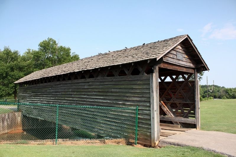
Near Recreation Drive east of Mc Cullars Lane, on the left when traveling east.
was moved on August 17 , 1990 to Oxford Lake
Leon Smith, Mayor
City of Oxford Councilmembers
Johnny Austin • Johnny Bentley • Bruce Dempsey
Norma Martin • Marshall Shaddix
The bridge was donated to the City of Oxford
by the . . . — — Map (db m198533) HM
On College Street (County Route 20) 0.1 miles south of South River Road, on the right when traveling north.
Cherokee Chief Pathkiller owned a ferry across the Coosa River at this location in the early 1820's. His home was a short distance on the east side of the river. Upon Pathkiller's death in 1827, John Ride, a prominent Cherokee gained a majority . . . — — Map (db m114281) HM
Near Ashe Boulevard 0.4 miles north of NE 16th Street.
In 1832, the Alabama legislature authorized the Florence Bridge Company to construct this bridge across the Tennessee River. In 1840, it opened as a toll bridge. Twice damaged by storms, it was reopened in 1858 as a double-decked bridge by the . . . — — Map (db m40596) HM
Alabama is a very geological diverse state. The vast natural resources and biodiversity of Alabama can greatly be attributed to its geological history.
Clarkson Bridge is located in the physiographic region called the Cumberland Plateau, which . . . — — Map (db m106097) HM
On Eva Road Northeast (County Route 35) east of Scenic Dr NE, on the right when traveling south.
A true leader among men, Brindley was a multifaceted businessman
and visionary civic leader. As a member of the Flying 50 and
Chamber of Commerce, he served as a board member and President,
which led him to be involved with the construction of . . . — — Map (db m283171)
Near County Road 1043 west of County Road 1117, on the right when traveling north.
This 270 foot bridge was constructed in 1904, destroyed by a flood in 1921 and rebuilt the following year. The only remaining covered bridge in Cullman County, it was restored by the Cullman County Commission in 1975 as an American Revolution . . . — — Map (db m33833) HM
On U.S. 231 north of State Road 123, on the right when traveling north.
Veterans Memorial Bridge - 1921 This reinforced concrete river bridge, thought to be the first in Alabama. Was erected over Pea River in 1920-21 at a cost of $92,108.97. It was dedicated on August 3, 1921 as a memorial to the 57 men from Dale . . . — — Map (db m36511) HM
On Broad Street (Business U.S. 80) at Water Avenue, on the right when traveling south on Broad Street.
Edmund Pettus Bridge has been designated a National Historic Landmark. This site possesses national significance for its association with "Bloody Sunday," a seminal event in the Civil Rights Movement. Here, on March 7, 1965, law enforcement . . . — — Map (db m82037) HM
On Broad Street (U.S. 80), on the right when traveling north.
Highlights of Selma History
Dallas County was created by Territorial Legislature Feb. 9, 1818. Selma Land Company formed Mar. 19, 1819 by George Phillips, William Rufus King, Jesse Beene, Gilbert Shearer and Caleb Tate. Selma incorporated . . . — — Map (db m37679) HM
Near East Commerce Street at Court Street, on the right when traveling east.
The land area which now comprises the City of Wetumpka was inhabited by various Indian cultures prior to the inward migration of the white man at the turn of the 19th century. The largest Indian village near here was located on . . . — — Map (db m67936) HM
On Orline Street 0.1 miles south of Hill Street, on the right when traveling south.
In 1834, the Wetumpka Toll Bridge Co. built the first of four bridges spanning the Coosa River at this site. It was destroyed in a flood in 1844. A second toll bridge was completed the same year by John Godwin whose slave, Horace King, designed . . . — — Map (db m69449) HM
On Alabama Route 27 at County Road 7, on the right when traveling east on Alabama Route 27.
Cureton Bridge
Cureton Bridge was an old settlement named for the Cureton family who settled here in the early 1820's. The village was located on the East Fork of the Choctawhatchee River in western part of Henry County and Northeast of what . . . — — Map (db m164377) HM
On Hartford Road (Alabama Route 10) 0.6 miles east of County Road 46, on the left when traveling east.
First settler crossings were made here prior to 1817 on a log ferry operated by Robert Irwin. First bridge built by Prescott and Bemis and destroyed by flood of 1855. Second wooden covered bridge was completed in 1869 by ex-slave Horace King. Third . . . — — Map (db m71843) HM
On Alabama Route 227 at Busbey Ave, on the right when traveling north on Alabama Route 227.
Vital Memphis-Charleston Railroad, "backbone of Confederacy", spanned Tennessee River here. Bridge burned several times, 1862-3.
Gen. Mitchell (US), occupying Huntsville after Battle of Shiloh, seized Bridgeport in April 1862 and held it . . . — — Map (db m83788) HM
On Bradley Avenue 0.5 miles east of Hoffman Avenue, on the left when traveling east.
May 23, 1838 the deadline for the Cherokee to move west to Oklahoma, Gen. Winfield Scott was sent in to AL, TN and GA to round up the Cherokee and place them in stockades near what is now Chattanooga, TN and Ft. Payne, AL. In June of 1838 about . . . — — Map (db m197505) HM
On Richard Arrington Junior Boulevard South north of 1st Ave South, on the left when traveling north.
On May 10, 1919, soon after its completion, this 21st Street Viaduct was named the Rainbow Viaduct in tribute to Alabama's famous 167th Infantry of the Rainbow Division, renowned for Bravery and Honor. The 167th was the Nation's only regiment in . . . — — Map (db m83860) HM
On Ross Bridge Parkway 2.7 miles north of State Highway 150, on the left when traveling north.
In 1858 James Taylor Ross, a Scotchman, migrated to the South, acquired land and homesteaded in what is now Shades Valley. He provided land for the construction of a railway, including a bridge spanning Ross Creek. After the Ross family moved . . . — — Map (db m27302) HM
Near Tannehill Road 0.5 miles north of Confederate Parkway, on the right when traveling north.
This iron truss bridge was used by thousands of Birmingham area residents in the early 1900s while visiting Tapawingo Springs, once a popular swimming spot and tourist location in northeast Jefferson County.
The bridge was originally located . . . — — Map (db m107514) HM
On Cherokee Drive west of Pumphouse Rd, on the right when traveling east.
This rock bridge was created to access Goat Hill where Project homes were intended to be built and part of the water system was built. However, the home construction was attempted and halted. The water system storage tank was built on Cherokee Drive . . . — — Map (db m287170) HM
On Cherokee Drive north of Main Street, on the left when traveling north.
Constructed in the late 1800’s, this bridge was originally built across the Little Cahaba Creek as part of the Birmingham - to - Gadsden Highway. Jefferson County later moved the bridge to Ketona and in 1940 again dismantled it and moved it to Happy . . . — — Map (db m286419) HM
Near Hightower Place south of Veterans Drive ( Route 133), on the left when traveling south.
With a fourth grade education, Ezra Culver employed his own innovative concrete process in major 20th century projects. His construction experience included work on Yankee Stadium, Lincoln Tunnel and the Florida Keys bridges. — — Map (db m219299) HM
At the beginning of World War I, Chile was the largest supplier of nitrates, a key ingredient in explosive munitions, to the United States. The United States government became concerned that this steady supply might be affected or even cut off . . . — — Map (db m268966) HM
On Wheeler Dam Highway (Alabama Route 101) 0.5 miles south of County Route 584, on the left when traveling south.
Wheeler Dam
Wheeler Dam is located south of here on the Tennessee River, between Lauderdale County on the north and Lawrence County on the south. It is located 275 miles above the mouth of the Tennessee River at Paducah, Ky. on the Ohio River. . . . — — Map (db m105132) HM
On Murphy Drive 0.2 miles east of Wrights Mill Road (County Road 33), on the right when traveling east.
Side 1
Under President Franklin D. Roosevelt's New Deal (1933-1942), the Civilian Conservation Corps (CCC) was established to provide work for single young men. The CCC's Company 4448, Camp Alabama SP-12, began work in September 1935 to . . . — — Map (db m85164) HM
On Park Road 0.1 miles west of Rocky Brook Road, on the right when traveling west.
obverse
This is the last surviving covered bridge in Lee County. It was constructed about 1900 by Otto Puls over Wacoochee Creek in the Town's lattice truss design. Materials used in the 75 foot long bridge included longleaf heart pine, . . . — — Map (db m85337) HM
On Upper Fort Hampton Road (County Road 49) east of Railroad Street, on the right when traveling east.
Soon after this scene was captured of Union troops rebuilding Sulphur Creek Trestle, one mile south of here, in early 1864, the ring of hammers was replaced by the thunder of cannon fire. By the time the smoke cleared, more than 240 men were dead in . . . — — Map (db m154183) HM
On Heart of Huntsville Drive SW south of Constellation Drive, on the right when traveling south.
C.B. "Bill" Miller, of Miller and Miller, Inc., had a positive impact in all areas of the transportation industry across the State of Alabama. He has erected bridges, railroads, parks, pedestrian walks, airports, drainage, wastewater facilities, . . . — — Map (db m54247) HM
On Old Stage Road (County Road 5) 0.1 miles north of Hollinger Road, on the left when traveling north.
John Poebles had an established toll bridge over Little Escambia Creek in the early 1800’s. A dispute over the bridge arose between Poebles and John Hollinger. As a result Hollinger built a toll free bridge adjacent to Poebles’ toll bridge. — — Map (db m84378) HM
On Commerce Street, in the median. Reported missing.
Union Station & Riverfront Park
Transportation center of Montgomery located in this area for many years. First steamboat, the "Harriet," landed nearby 1821. City wharf constructed at landing place 1823. First railroad, Montgomery & West . . . — — Map (db m86470) HM
On Main Street West (Alabama Route 36) at Springdale Drive SW, on the right when traveling west on Main Street West.
An estimated 600 Confederate and Union troops skirmished on this site on April 7, 1864 for control of crucial troop movements south of the Tennessee River during the Federal occupation of North Alabama.
Confederate Brigadier General James . . . — — Map (db m72810) HM
Near Lock and Dam Road 0.5 miles south of Marina Parkway, on the right when traveling south.
In June 1985, the U.S. Army Corps of Engineers, Mobile District, opened the Tennessee - Tombigbee Waterway. This carefully planned engineering effort created a year-round commercial navigation route 234 miles long. Stretching from the rugged north . . . — — Map (db m179089) HM
On 14th Street at 5th Avenue, on the left when traveling west on 14th Street.
(obverse)
Before The Battle
All day that Easter Sunday the Confederate forces commanded by Col. Leon von Zinken awaited the Union Army they knew was on the way from Tuskegee. Lacking the men needed to hold it, they were forced to . . . — — Map (db m69058) HM
On Dillingham Street at Brickyard Road, on the left when traveling east on Dillingham Street.
Early in the afternoon of April 16, 1865 the first major act in the Battle of Girard-Columbus took place. Union General Emory Upton sent the First Ohio cavalry charging down old Crawford Road to capture the Dillingham Bridge, then known as the lower . . . — — Map (db m69060) HM
On Broad Street at Dillingham Street, on the right when traveling south on Broad Street.
(side 1)
Horace King a slave of John Godwin was construction foreman for the first Dillingham Street Bridge in 1832, when he and Godwin introduced the “town lattice” bridge design into the Chattahoochee Valley. King built most . . . — — Map (db m69064) HM
On U.S. 80 3 miles east of State Road 28, on the right when traveling east.
Side A In 1919 a rooster sale organized by Frank Derby raised money to begin construction of a bridge over the Tombigbee River at Moscow Ferry. This was the last link in the completion of the Dixie Overland Highway between Savannah and San . . . — — Map (db m38074) HM
On Student Union Drive 0.5 miles south of University Drive, on the right when traveling south.
1860 Captain W. A. C. Jones of Livingston designed and built the bridge of hand-hewn yellow pine put together with large pegs, clear span 88 feet, overhead clearance 14 feet, and inside width 17 feet, across the Sucarnoochee River on old State . . . — — Map (db m92661) HM
Near Horseshoe Bend Road (Alabama Route 49) 2.1 miles north of Freeman Road, on the left when traveling north.
Completed in 1908, the bridge was the first to span the Tallapoosa River between Dadeville and New Site. It was named in honor of Nora E. Miller, who owned the land upon which the bridge was located. Dadeville builder W. H. Wynn and his son, Will, . . . — — Map (db m223949) HM
(Front):Home Guard Defended Covered Bridge3 April 1865 - Brig Gen John T. Croxton’s Cavalry Brigade departed camp at Johnson’s Ferry (Old Lock 17 area) to the Watermelon Road ending in Northport. As the Union troops entered Northport, the . . . — — Map (db m35679) HM
Near Greensboro Avenue north of 2nd Street (Jack Warner Parkway).
The remains of Burns' Shoals now lie nearly 40 feet underwater. This rock outcropping was the first of the shoals known as the "Falls of Tuscaloosa" and represents the "Fall Line" or contact point of the Coastal Plain and the Appalachian Plateau, . . . — — Map (db m28904) HM
Near Greensboro Avenue near 2nd Street (Jack Warner Parkway).
Born a slave in South Carolina in 1807, Horace King became a master bridge builder while working with John Godwin. With the aid of Tuscaloosan Robert Jemison, King was freed by act of the Alabama legislature in 1846. He went on to build many bridges . . . — — Map (db m235771) HM
On 2nd Street at 28th Avenue, on the right when traveling west on 2nd Street.
This wooden and steel truss bridge was constructed for the Mobile and Ohio Railroad in 1898 by civil engineer Benjamin Hardaway, an 1887 graduate of The University of Alabama and former Tuscaloosa City Engineer. Originally 135-feet high with a . . . — — Map (db m28992) HM
On Kinlock Road, on the right when traveling south.
The word "Kinlock" is of unknown origin although there is a Scottish site of the same name. The Kinlock Historic District was determined eligible for the National Register of Historic Places in 2000 and includes many sites:
the Rock Shelter, which . . . — — Map (db m248357) HM
On Bus Concessionaire Road at Murie Road, on the right when traveling west on Bus Concessionaire Road.
When you ride the rails, you hurdle yawning canyons
and wide rivers that challenged the engineering know-how of the day.
The Hurricane Gulch bridge, one of the marvels of the line,
crosses a gorge more than 900 feet across and . . . — — Map (db m283588) HM
On 1st Avenue at Cushman Street, on the left when traveling east on 1st Avenue.
Presented to the People of Fairbanks
by
Festival Fairbanks 84
and
The Fairbanks Downtown Association
[Dedicated] January 3, 1984 — — Map (db m257086) HM
“Instead of row after row of empty houses (Dawson), they are building new stores. The place is alive and busy-a little too crowded when we got there.” – a tourist in Fairbanks, 1928 — — Map (db m47406) HM
On Calhoun Avenue north of West 4th Street, on the left when traveling north.
Built by the Civilian Conservation Corps — 1935
Olaf Torkelson, Juneau Street Commissioner from 1924-1936, was instrumental in the success of this project. The overpass was built to provide safe access for children who attended Capital School . . . — — Map (db m181738) HM
Local ferries once plied a triangular route linking Juneau, Douglas, and Thane. These three communities, each centered on a major mine, eventually merged into one. In 1935, a bridge was constructed linking Douglas Island with the mainland.
In . . . — — Map (db m181794) HM
On Front Street at Water Street, on the right when traveling south on Front Street.
Shipments of iced halibut from Ketchikan to outside markets was pioneered by F.J. Hunt and H.C. Strong, following similar successful methods with salmon, and a thriving business was built through the construction of two large cold storage . . . — — Map (db m181914) HM
On McCarthy Road (at milepost 29), on the left when traveling west.
“In constructing high trestles and in laying steel track on beds of ice and snow, storms, high winds, and extreme cold tried the patience and fidelity of the strongest and most faithful.” — Cordova Daily Alaskan April 1, . . . — — Map (db m173892) HM
On Richardson Highway (State Highway 1/4 at milepost 126.6), on the left when traveling north.
In 1943, without any warning to the villagers, the Alaska Road
Commission (ARC) crews began construction of a new bridge across
the Gulkana River. The approach from the west side of the river divided
the village in two and passed within a few . . . — — Map (db m255421) HM
On Rim Trail north of Yavapai Point, on the right when traveling west.
Constructed in 1928, the Kaibab Trail Suspension Bridge was the only crossing of the Colorado River in a distance of 754 miles from Moab, Utah to Needles, California. Built in a remove location with incredibly difficult access through rugged . . . — — Map (db m173929) HM
Near U.S. 89A at milepost 537, on the right when traveling west.
John Deering (Bih Bitoodnii Nez) born 1870 of the Deer Water Clan, his wife Susie Deering, born in 1878, of the Maii Deeshgiizhinii Clan, and their nine children, pioneered the areas of the Gap, Copper Mine, Cedar Ridge, Bitter Spring, Page, Marble . . . — — Map (db m189730) HM
In memoriam to ironworker Lafe McDaniel
October 3, 1887 to June 12, 1928
The only individual to die during the construction of the Navajo Bridge, Lafe McDaniel, a well like and highly experienced Kansas City ironworker, fell from near . . . — — Map (db m206713) HM
Navajo Bridge
has been placed on the
National Register
of Historic Places
By the United States
Department of the Interior
August 31, 1981 — — Map (db m94885) HM
There are three markers on this end of the Navajo Bridge.(Marker on left:)
National Historical Civil
Engineering Landmark
American
Society of
Engineers
1852
Designated by the American Society of Civil Engineers . . . — — Map (db m94887) HM
This Erection Toggle Screw was used in the construction of the historic Navajo Bridge to maintain bridge vertical elevations and as a means of lowering bridge sections in place. — — Map (db m38469) HM
Glen Canyon Bridge
Majestic Glen Canyon Bridge, 865 feet (264 meters) downriver from the dam, was the highest steel-arch bridge in the United States when completed.
The roadway is 700 feet (213 meters) above the surface of . . . — — Map (db m101903) HM
On The Apache Trail (Arizona Route 88 at milepost 242) south of Route 188.
Before dam modifications could begin, a $21.3 million bridge was built to relocate traffic off the top of Roosevelt Dam. Roosevelt Lake Bridge is the longest two-lane, single-span, steel-arch bridge in North America. The bridge, spanning 1,080 feet . . . — — Map (db m134161) HM
On Black Hills Back Country Byway 1.9 miles north of High Tank Road, on the right when traveling north.
Constructed – 1918
Rededicated – 1997
Greenlee County Board of Supervisors • Arizona Department of Transportation • Federal Highway Administration • Bureau of Land Management • State Historic Preservation Office • Cannon and Associates, Inc. • . . . — — Map (db m195854) HM
On Old US 80 Highway (U.S. 80), on the left when traveling west.
Main Marker - Side A:
The Historic Gillespie Dam Bridge spans the Gila River on Old US 80 Highway, between the communities of Arlington and Gila Bend. Built in 1927 as a Federal Aid Project, the bridge is a unique and elegant reminder of . . . — — Map (db m54936) HM
On Old Highway US 80 (at milepost 22.5), on the left when traveling north.
In December 2011, as the Historic Gillespie Dam Bridge approached its 85th year of service, the Maricopa County Department of Transportation began a major bridge rehabilitation and repair effort to save one of Arizona's earliest and most significant . . . — — Map (db m69445) HM
Near Bloody Basin Off-Road Trail, on the left when traveling east.
Marker 1 - (Main Marker):
The original Verde River Sheep Bridge, also known as the Red Point Sheep Bridge, was constructed at this location in 1943 by Flagstaff Sheep Company, which had been grazing sheep in the area under a Forest . . . — — Map (db m53966) HM
Near North Horne Avenue 0.4 miles south of East McKellips Road.
Approximately 300 B.C. Prehistoric Indians entered the Salt River Valley. They developed an extensive canal system and raised corn, beans, squash, agave and cotton.
Over 500 miles of Hohokam canal have been recorded in the Salt River . . . — — Map (db m49877) HM
On Hoover Dam Access Road, on the right when traveling west.
Hoover Dam was considered critical to the war effort because of the electricity it generated and the water stored in Lake Mead.
America’s enemies knew how significant the dam was, too. As early as 1939, a plot to bomb the intake towers by . . . — — Map (db m254652) HM
On Hoover Dam Access Road, on the right when traveling west.
There have been a lot of changes since Hoover Dam was complete in 1935.
Among those changes are a bridge that rivals the dam as an engineering achievement. But the old is as impressive as the new. Nearly a century after its builders met . . . — — Map (db m254651) HM
On McCulloch Boulevard 0.1 miles south of Route 95, on the right when traveling south.
"We are now friends with England and with all Mankind."
Written by Benjamin Franklin, American Peace
Commissioner in Paris, following the signing of the peace treaty ending the American Revolution
September 1783
With American and . . . — — Map (db m31843) HM
On McCulloch Blvd. 0.1 miles south of Route 95, on the right when traveling south.
Robert P. McCulloch, Sr, Founder
and
C.V. Wood, Jr., Master Planner
London Bridge was purchased from the city of London on April 18, 1968 for $2,460,000.00. It took three years and another $4,500,000.00 to transport and build the bridge. The . . . — — Map (db m31841) HM
The boundary of the City of London England, established in Roman times, is marked by a heraldic dragon at each entry by freeway. This dragon marks the boundary of London land in Lake Havasu City. — — Map (db m269084) HM
On Arizona Route 95 south of McCulloch Blvd. N when traveling south.
Opened By
The Right Honorable The Lord Mayor Of London
Alderman Sir Peter Studd G.B.E.M.A.D.Sc.
In The Presence Of
The Honorable Jack Williams
Governor Of Arizona
October 10, 1971
Robert P. McCulloch Sr C.V. Wood Jr. . . . — — Map (db m4328) HM
On McCulloch Boulevard North, on the right when traveling west.
[Upper Plaque]:
In grateful memory
Robert P. McCulloch, Sr.
Whose purchase of London Bridge
in 1968
saved it for the enjoyment and use
of posterity
[Lower Plaque]:
October 10, 1981
on this 150th Anniversary . . . — — Map (db m6974) HM
Six hundred feet to the west of this location stood the original Little Colorado River Bridge. This steel truss bridge designed by the Arizona Highway Department stood at that location for 1928 to 1988. This landmark structure remained intact and . . . — — Map (db m95155) HM
On Pinedale Road 0.5 miles south of Route 260, on the left when traveling south.
In recognition of her unselfish participation and example in community beautification. Serving on the town bicentennial committee, she proposed the covered bridge and the planting of pine trees along the lane north to the highway as being worth . . . — — Map (db m36665) HM
On 2nd Street (Arizona Route 66), on the left when traveling east.
This date medallion is from the Winslow Bridge that once spanned the Little Colorado River on historic Route 66 just east of Winslow. Because the river had always proved a daunting impediment to travelers, this bridge crossing became a strategic . . . — — Map (db m32781) HM
On Country Road 1.1 miles north of Woodruff Hay Hollow Road, on the right when traveling north.
Owner
Navajo County, AZ
Design Engineer
American Bridge Company
Rehabilitation Engineer
Jerry A. Cannon
The Little Colorado River formed one of the most formidable obstacles to transcontinental travel across Arizona on Route 66. The . . . — — Map (db m195839) HM
On South Randolph Way at East Camino Campestre, on the right when traveling south on South Randolph Way.
[ Four markers are mounted on the four sides around the base of the monument. ]Side A:
Southern Pacific Railroad Map
Epes commanded the "Randolph Lines" that connected Phoenix and southern Arizona's outlying communities . . . — — Map (db m38936) HM
Memorial to Francisco Garcés, explorer and first Franciscan missionary to the Pima village at the foot of Sentinel Peak. In 1770 Garcés and the Pimas constructed at that site the first substantial building in Tucson, a mission residence with two . . . — — Map (db m83034) HM
On North Fourth Avenue at East 9th Street, on the right when traveling south on North Fourth Avenue.
Tucson City Engineer ― Jim Clock
Design Engineer ― Cannon & Associates, Inc. TranSystems Corp.
Contractor ― Sundt Construction, Inc.
Long known as the Gateway to the East End of Downtown, the Fourth Avenue Underpass in a . . . — — Map (db m31527) HM
On North Fourth Avenue at East 9th Street, on the right when traveling south on North Fourth Avenue.
Tucson City Engineer ― J. Mos Ruthrauff
Design Engineer ― L. R. Walker
Contractor ― Bent Brothers
In 1913, in an effort to separate pedestrians, vehicles, bicycles and wagons from trains, the City of Tucson embarked on a . . . — — Map (db m31526) HM
Near Sabino Canyon Road at North Kolb Road, on the right when traveling north.
On November 30, 1944, at 7:40 A.M. 18 airmen from Davis-Monthan Army Air Field died following a mid-air collision between two B-24 Liberator Bombers over the Pantano Wash. This bridge is dedicated to those brave men who lost their lives while on a . . . — — Map (db m100761) HM WM
Near Prison Hill Road 0.5 miles north of Harold C. Giss Parkway.
The gray bridge, finished in 1915, is the "Ocean to Ocean" Highway Bridge. This was the final link in a highway stretching from the Atlantic to the Pacific coast. Its presence meant travelers no longer had to wait for the ferry to cross the . . . — — Map (db m158287) HM
On Penitentiary Avenue 0.5 miles north of East 1st Street, on the right when traveling north.
In 1913 after strong campaigning from the citizens of Yuma, Representative Carl Hayden secured funding for this bridge. When completed, it was the only highway bridge across the Colorado River for 1,200 miles. It was partially funded by the Office . . . — — Map (db m46786) HM
Near Prison Hill Road 0.5 miles north of Harold C. Giss Parkway.
Below the junction of the Gila and the Colorado rivers was the only natural ford on the southern trail to the Pacific. Though often menacing, Indians helped early travelers across on crude rafts. Several ferries operated from 1850 on. Best known . . . — — Map (db m158300) HM
Davies Bridge, a sturdy Rustic-style structure, stands today as an emblem of the park's Civilian
Conservation Corps (CCC) heritage and the Davies family's contributions to Arkansas State Parks.
In 1932, Samuel G. Davies, a graduate of . . . — — Map (db m233672) HM
As you explore these unique structures around Petit Jean State Park,
you will find that nature and history are strongly connected here.
Rock House Cave - Explore this sandstone
bluff shelter and look for ancient Native
American . . . — — Map (db m233679) HM
Near North 3rd Street 0.1 miles south of Knox Street, on the right when traveling south.
John Drennen made profitable choices during his diverse professional life as merchant, bank trustee, plantation owner, and Indian agent.
He linked his future to the fledgling town of Van Buren, and built his family home here, . . . — — Map (db m120426) HM
Era Ends, Era Begins
Large-scale farm and businesses were established here during the early 1800s, when people relied heavily on riverboats for transportation. As a formal community, Snow Lake was established with the arrival of the railroad . . . — — Map (db m299922) HM
Near U.S. 63 at Main Street (State Route 9), on the right when traveling north.
You are standing on the support for a bridge across Spring Lake. The bridge provided an important link between the train station and the city of Mammoth Spring. The first bridge, made of wood, was replaced by a steel bridge. The steel bridge was . . . — — Map (db m192168) HM
On Highway 46 2 miles south of Highway 291, on the right when traveling south.
Jenkins Ferry
In 1846, Thomas Jenkins paid the Saline County clerk $1 to register to “keep a ferry” and charge travelers to cross the Saline near the mouth of Cox’s Creek when the river was at flood stage. Gen. Frederick . . . — — Map (db m121204) HM
On Arkansas Route 168 0.6 miles north of Route 141, on the right when traveling north.
Crowley's Ridge State Park is here today due to the hard work, dedication, and ingenuity of the local community and the Civilian Conservation Corps.
Roosevelt's Tree Army
The men of Civilian Conservation Corps (CCC) companies
1729, 2736, . . . — — Map (db m170556) HM
On Pavilion Road east of Martin Luther King Boulevard (Business U.S. 270), on the left when traveling east.
Gen. Frederick Steele led a Union army from Little Rock on March 23, 1864, to join an invasion of Texas. Confederate skirmishers harassed the army as it reached Rockport March 27. An inflatable pontoon bridge, in 34 wagons and served by men of . . . — — Map (db m121148) HM
On Hickory Street (U.S. 71) at E 3rd Street, on the right when traveling south on Hickory Street.
This is the site of the Old Broad Street Bridge, also known as the Hickory Street Viaduct. The Arkansas Highway Department designed the Bridge, and the Ottinger Brothers of Hinton, Oklahoma, built it in 1940 for the Texarkana Grade Separation . . . — — Map (db m285028) HM
On State Highway 7 0.2 miles south of County Road 80, on the right when traveling south.
This is the site of the Old Buffalo River Bridge also known
as the Pruitt Bridge. The Arkansas Highway Department
designed the bridge in one day. Fred Luttjohann of Topeka,
Kansas built it in 1931 for a contract bid of $55,226.09.
The Virginia . . . — — Map (db m225343) HM
Flooding, a long-feared natural phenomenon, is a very real concern throughout the region. Water has spilled from the banks of the Mississippi many times over the years, causing widespread fear and devastation. The Great Mississippi Flood of 1927, . . . — — Map (db m231575) HM
Built in 1961, the Helena bridge is about a mile long and 28 feet wide. It stretches across the Mississippi River, linking Helena with the town of Lula, Mississippi via US 49.
Before the bridge
Until the early 1960s, there was no bridge . . . — — Map (db m231574) HM
On South First Street (Arkansas Route 161) 0.3 miles south of Carver Lane, on the right when traveling south.
As Gen. John Davidson saw flames erupting from the only bridge across Bayou Meto, he ordered Lt. Col. Daniel Anderson to take his First Iowa Cavalry Regiment and save the bridge, if possible. Anderson and his men thundered down the Memphis to . . . — — Map (db m116543) HM
The first action of the Battle of Reed's Bridge occurred east
of where you are standing when 125 Missouri Confederates
opened fire on Brigadier General John Wynn Davidson's
Union cavalry division at about 11 a.m. on August 27, 1863.
The . . . — — Map (db m116603) HM
3762 entries matched your criteria. The first 100 are listed above. Next 100 ⊳