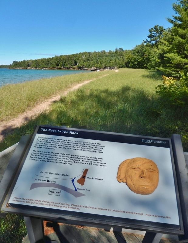
The sculpture to the right replicates a rock carving as made in 1820 by a French trapper and guide who accompanied Lewis Cass, governor of the Michigan Territory. Cass was on an expedition along the south shore of Lake Superior on his way to what . . . — — Map (db m154477) HM
The Grand Island Nishnaabe had many of their spring, summer, and fall needs met on the island, but they also visited the mainland for seasonal foods and hunting. Sand Point provided luscious cranberries. The Anna River and other streams provided . . . — — Map (db m154478) HM
The main portion of this building was the residence of George N. Smith, a Congregational missionary to the Indians in this area and at Waukazoo's Village on nearby Lake Macatawa. The mission was named after an Indian convert. Built in 1844-45 by . . . — — Map (db m73683) HM
It is hard to imagine now, but 200 years ago, the place we know as Wayland was densely forested and the people who lived here, the Match-E-Be-Nash-She-Wish Band of the Pottawatomi, lived in settled villages, farming, hunting, and gathering the rich . . . — — Map (db m73677) HM
“By the Treaty of Saginaw, made at Saginaw [Saquina] September 24, 1819, by General Lewis Cass, Governor of the Northwest Territory, on the part of the United States, and the Chippewa Nations, Thunder Bay River became a part of the boundary of the . . . — — Map (db m182328) HM
Before America was discovered, indigenous people hunted and fished the Grand Traverse region for thousands of years. As far back as 8,000 B.C., the waters of Grand Traverse Bay, Elk River and the 14 lakes of Antrim County's Chain of Lakes had been . . . — — Map (db m98175) HM
Native Americans have hunted and fished the Grand Traverse region for thousands of years, perhaps as many as 10,000 years before white settlers appeared. The waters of the Bay, Elk River and the 14 lakes of Antrim County's Chain of Lakes had been . . . — — Map (db m98128) HM
In the early nineteenth century the Thornapple band of Ottawa Indians established a village a short distance from Thornapple Lake. It was served in the 1840s by a Methodist mission and school conducted by the Reverend Mannaseh Hickey. Trails leading . . . — — Map (db m191511) HM
Established in 1847, the Ogaukawning Indian Mission, the first church in present-day Bay County, served Chippewa Indians at the nearby Kawkawlin settlement. First ministered by Methodist missionaries, it soon came under Indian trusteeship and still . . . — — Map (db m182297) HM
This boulder is erected
to the memory of
O-Ge-Ma Ke-Ga-To
Chief Speaker of the Chippewas
Born about 1794,; elected chief, 1815;
spoke at treaty, 1819; spoke before
Congress, 1837; died, 1840
First buried on property now known . . . — — Map (db m180642) HM
This bay derives its name from the Sauk Indians who once dwelt by its shores. Adrien Jolliet, on his voyage down Lake Huron’s western shore in 1669, first made it known to the white man. In the late 1800's an immense lumber industry flourished in . . . — — Map (db m182360) HM
This house built in 1849, by Eleazar Morton and his son Henry, was occupied until 1936 by four generations of Mortons. The oak-framed barn was built in 1840. Members of the Morton family, pioneers in this area, were prominent in Benton Harbor's . . . — — Map (db m43844) HM
Known as Parc aux Vaches, or “cow pasture,” this area was named by the French for the wild buffalo that once grazed here. Two major Indian trails crossed here: the Sauk Trail, also called the old Chicago Trail, which linked Detroit and . . . — — Map (db m64552) HM
People have lived on the terrace between Moccasin Bluff and the St. Joseph River for eight thousand years. The first inhabitants stayed in small temporary camps as early as 6300 B.C. The residents of A.D. 500 traded with groups in Indiana and . . . — — Map (db m217846) HM
Logo text:
"Pokégnek Bodéwadmik" (Pokagon Band of Potawatomi)
New Buffalo was founded during an era of Indian removal from the region. Historically, the Potawatomi lands included millions of acres in Southern . . . — — Map (db m202624) HM
The French fort built here in 1691 controlled southern Michigan’s principal Indian trade routes. Missionaries and fur traders were here already. The fort became a British outpost in 1761. Two years later it was one of the forts seized by Indians . . . — — Map (db m1628) HM
The Chapin House.
This Queen Anne style house, completed in 1884, was the Henry A. Chapin family home until 1902. In 1932, when the City of Niles bought the property at auction for $300, the Chapin children stipulated that it be used only for . . . — — Map (db m1706) HM
William Burnett, an American patriot from New Jersey, established a trading post on the bank of the St. Joseph River immediately east of this point between 1775 and 1782. He was the first permanent white resident of this area. He married Kakima, . . . — — Map (db m64855) HM
Potawatomie Indians ceded Coldwater Prairie to the United States in 1827. The Indians called it “Chuck-sew-ya-bish,” meaning “cold spring water.” Coldwater is located at the junction of Old Sauk and Fort Wayne Indian trails. . . . — — Map (db m65858) HM
To Commemorate
the memory of
The Pioneers
and
First Surveyors
who by perilous efforts
over the Indian trail
made possible
the magnificent highway
M-23
Marked by
The Coldwater Chapter
Daughters of American . . . — — Map (db m241051) HM
Long before European settlement and Union City, the St. Joe was known by Native Americans as the River of the Miamis. It was an important resource for water, game, fish and transportation. The origin of the St. Joe is found in the lake in Hillsdale . . . — — Map (db m95242) HM
Late in the seventeenth century, early French voyageurs made use of the entire length of the St. Joe in their push westward. The French built forts on the river at St. Joseph (1679) and Niles (1691) as strongholds for the fur trade. A memoir to the . . . — — Map (db m95224) HM
In commemoration of
Te-kon-qua-sha
1768 ★ 1825
Chief of the Pottowatomies
This village - Tekonsha - named in his honor, is located on the site of the old Indian village governed by that chief. — — Map (db m224996) HM
Chief Leopold Pokagon and his tribe of Potawatomi Indians built a log church here in 1838 and deeded the forty acres of land on which it stood to the Catholic Bishop of Detroit. Pokagon, who came to Silver Creek Township from his village outside of . . . — — Map (db m64735) HM
(Obverse Side)
Sumnerville Mounds
Between the first and fourth centuries A.D. Hopewell Indians built nine burial mounds near here. The six remaining earthen mounds reflect the Hopewellian culture, which flourished in the Eastern . . . — — Map (db m64742) HM
(Side A)
Big Rock Point
Big Rock Point is named for a large boulder used as a landmark by Native Americans. At least as early as the mid-nineteenth century Odawa (Ottawa) Indians used Big Rock, which they called Kitcheossening, as a . . . — — Map (db m97483) HM
Here in the 1840's the Chippewa Indian missionary, Peter Greensky, established a Protestant mission in an area where legend says Indian chiefs once held their councils. New trees have been planted in an arrangement similar to that of the trees that . . . — — Map (db m215921) HM
The name "Cheboygan" probably comes from the Annishinaabe or Chippewa word "zhiibaa'onaii," meaning a channel or passage for a canoe. This mural depicts some of the earliest known individuals to have made Cheboygan home during its beginnings. . . . — — Map (db m121797) HM
The Pipe:
Voyageurs often smoked white clay pipes as they travelled the waters of the Great Lakes region in their large freight-hauling canoes. Bodies of water were known as a "two-pipe lake" or "five-pipe crossing" depending on the number of . . . — — Map (db m121799) HM
Huron Shore Trail
follows the geologic Algonquin Beach Ridge formation along the western shore of Lake Huron from the Straits of Mackinac to Saginaw Bay. For centuries this trail was the primary travel route for Chippewa people travelling . . . — — Map (db m121805) HM
Huron Shore Trail
follows the geologic Algonquin Beach Ridge formation along the western shore of Lake Huron from the Straits of Mackinac to Saginaw Bay. For centuries this trail was the primary travel route for Chippewa people travelling . . . — — Map (db m121887) HM
River mouth and cattail marsh:
Captain Samuel Robertson wrote in the 1770s, "…the most safest place near Michilimackinac [Mackinac Island] for wintering vessels is the River Shaboygan, there is six feet water upon the Barr, the River is about . . . — — Map (db m121888) HM
This structure served as the Cheboygan County sheriff’s residence and jail from 1880 to 1969. The building originally had seven cells. Faced with overcrowding, the county built an additional sixteen cells in 1912. During the local lumber boom . . . — — Map (db m121800) HM
In 1761 Alexander Henry from New Jersey was one of the first English traders to venture into the interior of Michigan and came here to Fort Michilimackinac.
Each summer, thousands of Indians led by their chiefs came to receive presents from . . . — — Map (db m141187) HM
Chief Wawatam, an Ojibway Indian living at the Straits of Mackinac, befriended the British fur trader Alexander Henry as a brother. During the Indian attack on Fort Michilimackinac in 1763, Wawatam protected his friend and cared for him as a member . . . — — Map (db m131697) HM
Chief Wawatam was revered for his bravery and fidelity
Chief Wawatam, an Ojibway Indian living at the Straits of Mackinac, treated the British fur trader Alexander Henry as a brother. During the Indian attack on Fort Michilimackinac in . . . — — Map (db m214253) HM
Fort Michilimackinac
Around 1715 Constant Le Marchand de Lignery established Fort Michilimackinac for the French at the site of a Jesuit mission. During the next fifty years as France and Great Britain struggled for control of the fur trade . . . — — Map (db m131748) HM
The first people came to the Mackinaw region aboutr 10,000 years ago, just after the glaciers retreated. They were summer hunters stalking the big game of mastodons and mammoths. The development of birch bark canoes made coming and going much . . . — — Map (db m140760) HM
In memory of
John L. (Jack) Staffan • Chief Wawatam
August 1, 1909 - November 7, 1982
In tribute to our friend Jack Staffan, whose
participation, leadership and enthusiasm in the
Fort Michilimackinac Pageant spanned 20 years
of . . . — — Map (db m140815) HM
From 1715 to 1761, the pure white flag of France flew over Michilimackinac. The Fleur-de-lis, although part of the official royal flag of France, was rarely used on flags in French Canada. The white flag, flown over all ships and coastal forts, . . . — — Map (db m232257) HM
Straits of Mackinac - a juncture in travel
Transportation through the Straits of Mackinac has changed dramatically over the centuries. The earliest inhabitants travelled by boat and found the Straits a convenient east-west highway linking . . . — — Map (db m232261) HM
The central location of the Straits of Mackinac on the water highway system and the proximity of numerous Native tribes made it an ideal home base for the Upper Great Lakes fur trade. The Straits of Mackinac functioned as a fur trade summer depot . . . — — Map (db m232259) HM
Native American History Links Past to Present and People with the LandAccording to traditions and historical evidence, Whitefish Bay is part of the central Anishinabeg (Ojibwe or Chippewa) homeland in the Great Lakes. Members of the nearby Bay . . . — — Map (db m154414) HM
Ice-Age glaciers covered the Whitefish Bay Area for thousands of years and left behind a complex mosaic of sand, gravel and clay. Following the last glacier's retreat about 10,000 years ago, water and wind shaped these deposits into the landscape of . . . — — Map (db m154413) HM
When the first French traders and missionaries arrived in the 1600s, the Native American Tribe called Ojibwe or Chippewa lived along the Bay. They referred to themselves in their native language as Anishinabeg, which translates as "Original People." . . . — — Map (db m154415) HM
Unlike more remote or isolated stations surrounded by water, life at Point Iroquois included many land-based activities and contacts with neighbors. Lighthouse Service rules and regulations strongly encouraged self-sufficiency through the use of . . . — — Map (db m154409) HM
This light, the oldest active on Lake Superior, began operating in 1849, though the present tower was constructed later. Early a stopping place for Indians, voyageurs, and Jesuit missionaries, the point marks a course change for ore boats and other . . . — — Map (db m40054) HM
This statue depicts the Chippewa legend of two young brothers who flee their wicked mother who is pursuing them with the intent to kill them. When they reach the north shore of the St. Mary's Rapids they are met by a crane. Who after hearing . . . — — Map (db m213641) HM
This statue is an exact replica of the original which stands in the Capitoline Museum of Rome, Italy. The statue depicts the Roman legend of twin sons of a vestal virgin. Romulus and Remus, who were abandoned by their mother to die. They were . . . — — Map (db m213635) HM
Anishinaabek oral history relates that long ago Gchi-Manito (Creator) sent a bird to make its abode on the earth. This bird, Ajiijaak, (crane) circled the land and saw the abundance of Adikameg (whitefish) and after coming to rest on Wadjiwong (a . . . — — Map (db m214152) HM
Sault Ste. Mire, including the campus of Lake Superior State University is steeped in a rich history originating as a natural gathering place for Native Peoples who refer to the Sault Rapids area as "Bahweting."
This copper sculpture was created . . . — — Map (db m214251) HM
Appointed Indian agent in 1822, Henry Rowe Schoolcraft (1793-1864) requested that the government provide a suitable structure to house the agency. Obed Wait, designer of Michigan's territorial capitol in Detroit, directed the construction of this . . . — — Map (db m213411) HM
Former home and trading post
of the
John Johnston Family
second oldest building in the northwest
built in 1795 - 96
Here in 1824,
Henry Rowe Schoolcraft, historian
married Jane,
daughter of Johnston
and his O'Jibway Indian . . . — — Map (db m213416) HM
A native of Ireland and a Protestant, John Johnston (1762-1828) arrived on the Lake Superior frontier in the early 1790s. He married the daughter of a powerful Chippewa chief and settled here in 1793. Johnston's knowledge of the Chippewa and the . . . — — Map (db m213414) HM
Several Methodist ministers were active in missionary work in the "Soo" area in the 1830s. John Sunday, an Indian preacher from Canada, began mission work in the Indian settlement at the Sault Ste. Marie Rapids around 1831. The Reverend John . . . — — Map (db m213422) HM
The adjacent building
is the Sault Ste. Marie Indian Agency
built in 1827 by
Henry Rowe Schoolcraft
Author, historian and foremost
authority on American Indian
life, manners and customs.
Here Schoolcraft wrote some of the
books . . . — — Map (db m192400) HM
riginally an Indian Path, this
road connected DeWitt with
the Capitol at Detroit and
Grand Haven on Lake Michigan.
It was opened as a military road
by the government in the late
1830's and at that time provided
settlers with the only access . . . — — Map (db m239677) HM
Chief Shoppenagon
Chief David Shoppenagon was born in Indianfields, a Chippewa Indian Village in the Saginaw River Valley. In 1795 his grandfather, also a Chippewa chief, was among the Indians who met with General Anthony Wayne at Fort . . . — — Map (db m200599) HM
Indians of early copper culture occupied the Bays de Noc over 5,000 years ago. We know when French explorers came to this area, they were greeted by members of the Noke tribe. The Nokes territory extended from north Green Bay and the Bays de Noc . . . — — Map (db m137243) HM
The Noquet (or Noc) Indians, who once lived along these shores, gave this bay its name. Here at Sand Point, in 1844, Douglass Houghton came with his party of government surveyors to chart the land to the north. In 1864 the first ore dock was built . . . — — Map (db m137285) HM
Escanaba River: The Legend
This is the land of the Chippewa Indians and the legendary Hiawatha. Indian villages existed along the banks of the river, and Indians were living here when the first white men came to this region in the 1600's. . . . — — Map (db m139220) HM
Migrant Indian tribes led by the famous Chief Okemos called this area "Big Rocks." They came here in early spring to tap the sugar maples. Later, the beauty of the ledges and woods attracted the Grand Ledge Spiritualist Camp Association which, in . . . — — Map (db m122708) HM
1600s - In the mid 1600s, the Jesuit Fathers established an extensive log mission station first below and then here on the bluff. The Odawa called it Ahnamiwatigoning or Prayer Place by the Cross and the French called this settlement La Croix or . . . — — Map (db m229606) HM
This was the name given by the French to the region from Cross Village to Harbor Springs because of a large crooked tree that stood on the crest of the bluff. Visible for many miles, it marked the center of a large Odawa Indian settlement. — — Map (db m97815) HM
In this area, beneath a large tree, tribal chief of the Menominee, Ojibwe, and Odawak held many councils in the late 1700's. The tree was also used as a navigational tool during seasonal migrations. — — Map (db m97840) HM
A flowing spring in this ravine was believed by area Odawa Indian Bands to be the home of spirits who made their presence known in this location during the hours of darkness. — — Map (db m229688) HM
Educated first in Odawa (Ottawa) skills and traditions, Andrew J. Blackbird struggled to find the resources to attend Euro-American schools. He eventually studied at Ypsilanti State Normal School. His command of English enabled him to work as an . . . — — Map (db m97603) HM
Andrew J. Blackbird House
Andrew J. Blackbird (c.1815 - 1908), an important figure in the history of the Odawa (Ottawa) tribe, was the son of a chief. Educated in the traditions of the Odawa, he also attended Euro-American . . . — — Map (db m97594) HM
Centuries before European arrival, the Odawa Chief Sagima and his war party drove the Muscodesh from this area. The murder of an Odawa woman, along with great insults toward the Chief at Seven Mile Point, resulted in war, leading to the eventual . . . — — Map (db m229690) HM
How Did the Odawa Survive? When the Odawa were living on the waterfront in the Straits what was their life like? What did they eat? What did they do? And wouldn't it be wonderful if we could ascertain what they thought? Here are the few answers . . . — — Map (db m154599) HM
Native families settle in the Straits area Following the glacial retreat 11,000 years ago, Anishnaabek people began to populate Lower Michigan, drawn here by plentiful natural resources. This land holds tremendous cultural value to the local . . . — — Map (db m154601) HM
Worlds collide in Mackinac’s “Middle Ground” Charles Michel de Langlade was an Odawa war chief, diplomat, fur trader and a French officer. He was one of the most influential people in the Great Lakes during the 1700s, due to his . . . — — Map (db m154700) HM
At the end of this trail, "Chi-Sin" rests on the shoreline of the Straits of Mackinac.
In Anishnaabek, the language of the indigenous people, the Odawa Indians, Chi-Sin means literally "Big Rock." The Big Rock at the McGulpin Point shoreline . . . — — Map (db m154699) HM
This fort, built about 1715, put French soldiers at the Straits for the first time since 1701. French authority ceased in 1761 when the British troops entered the fort. On June 2, 1763, during Pontiac's uprising, Chippewa Indians seized the fort, . . . — — Map (db m7670) HM
The Woodland Indians of the Northern Midwest are believed to be remnants of the prehistoric Middle Mississippian people. The common ancestry of various tribes is evident in their similar languages. The Huron tribe spoke an Iroquois language. The . . . — — Map (db m135127) HM
Post-war life at McGulpin Point With the turn into the 1800s, the social and economic systems in the Mackinaw area become more predictable. During this period Patrick McGulpin, now 60 years old, stopped having children and became a grandfather . . . — — Map (db m154820) HM
Roman Catholicism came to the Straits of Mackinac through the self-sacrificing efforts of seventeenth-century Jesuit Missionaries. In 1670 Father Jacques Marquette established a mission for Huron Indians on Mackinac Island. An . . . — — Map (db m135112) HM
European soldiers stay and become land owners For thousands of years, generations before the arrival of the French in the 1600s, the Anishnaabek nation established villages along the Straits of Mackinac, including near where you are standing . . . — — Map (db m154819) HM
Natives buried the bones of their bravest warriors under large stones they called "Warrior Stones" so they would not be forgotten.
This stone is dedicated to our Military, Law Enforcement, Fire / Rescuers and their Families.
-They too will . . . — — Map (db m201404) HM
Nissowaquet, a legendary Odawa Nissowaquet (Nosawaguet, Sosawaket, La Fourche), Odawa chief; the name evidently comes from Nassauaketon, meaning “forked river,” the designation of one of the four Odawa bands; b. 1715; d. 1797. . . . — — Map (db m154698) HM
Built in 1889...
The church below is the third to stand in the vicinity of the first Jesuit mission in 1741. It was rebuilt by the Indians in 1825 . . . — — Map (db m97791) HM
(Side A)
St. Ignatius of Loyola Church and Cemetery
By the 1740s, French Catholic missionaries had come to this area, known to the Odawa as Waganakising, to minister to local tribes. Later, missionary work was taken up by others, including . . . — — Map (db m97790) HM
The church below, built in 1889, stand[s] in the vicinity of the first Jesuit mission of 1741, which was rebuilt by local Waganakising Odawak carpenters and craftsmen in 1825. — — Map (db m97789) HM
For centuries this region has been the home of Ottawa Indians, whose warriors and orators fought bravely to retain their land. Around 1700 a mission was built by French Jesuits at the famous L'Arbre Croche villages which stretched from Cross . . . — — Map (db m55405) HM
This boulder marks
the Old Indian Trail from
Mackinaw City to Grand Rapids
used from time immemorial by
the Huron, Ottawa, Chippewa and
other tribes — — Map (db m97876) HM
From 1905 to 1915, summer resorters came here to experience “The Indian Play Hiawatha.” Canadian Louis O. Armstrong worked with Ojibwa from the Garden River Reserve in Ontario, to create the pageant. It had been presented in several places, . . . — — Map (db m233856) HM
This land was sold by Amawee, an
Odawa, to Jean Baptiste Trotochaud
and his Ojibwa wife Sophia
Anaquet. Later, they donated
nearly an acre of land to the
Catholic Church. Jean, under the
guidance of Father Sifferath,
built this Mission in . . . — — Map (db m233942) HM
Jacob Smith The first permanent structure erected on this site was probably the trading post built in 1819 by Jacob Smith, the founder of Flint. Fluent in English, French, German and a half dozen Indian languages, Smith represented the Chippewa . . . — — Map (db m179846) HM
Ottawa Indians once lived in the pine forest between Lakes Wahbekaness and Wahbekanetta. In the late 1800s white men came and cut the pines, leaving only a small forest between the lakes. This virgin pine was purchased in 1917 by the state and . . . — — Map (db m235219) HM
Dougherty Mission House
Peter Dougherty arrived on Mackinac Island in 1838, planning to establish a Presbyterian mission to the Ojibwe and Odawa tribes in northern Michigan. He selected the Grand Traverse Bay area and settled in Elk Rapids. . . . — — Map (db m168185) HM
French traders named this bay when they made “the long crossing” — la grande traverse — across its mouth. Chippewa and Ottawa tribes dwelt in this region. Peter Dougherty’s Indian Mission, established in 1839 at Old Mission, paved the way . . . — — Map (db m168174) HM
The Heritage Association 2017
Winona Daughter of The Chief
Daughter of Chief Baw Beese, leader of the Native American Potawatomi Clan, Winona lived in the region of Hillsdale County around the 1830's. Winona's mother was a French . . . — — Map (db m199676) HM