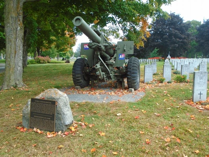
The 155-mm C1 Howitzer was a Canadian version of the American M1A1 Howitzer. Sorel Industries Limited in Sorel, Québec, manufactured 180 of them under licence for Canada and other NATO countries starting in 1953. It was the largest . . . — — Map (db m234840) HM
The 155-mm C1 Howitzer was a Canadian version of the American M1A1 Howitzer. Sorel Industries Limited in Sorel, Québec, manufactured 180 of them under licence for Canada and other NATO countries starting in 1953. It was the largest . . . — — Map (db m234846) HM
Société nationale d'entraide de la Médaille Militaire
Fondation du cimetière Beechwood Cemetery Foundation
Union des français de l'étranger
Français du monde - ADFE
Association des décorés de la Légion d’honneur . . . — — Map (db m234709) HM
Born in England, Foulkes joined the Canadian military after university, proving himself by leading his division through the Normandy campaign, and in November 1944, was promoted to General Officer Commanding of I Canadian Corps in Italy. . . . — — Map (db m234726) HM
"To the honoured memory of those
sailors, soldiers and airmen
who gave their lives for their country
in two world wars and who lie buried
in this cemetery" — — Map (db m234843) WM
The Cross of Sacrifice is a common feature found in Commonwealth War Graves Commission cemeteries and plots world wide. It emphasizes both the military character of the cemetery and the religious affiliation of the majority of the war . . . — — Map (db m234714) HM WM
Reg. No. 5529 Royal North West Mounted Police
October 31, 1917 as a member of the Canadian Expeditionary Force
was awarded the Victoria Cross for Valour at Passchendaele,
Belgium - First World War
No. de . . . — — Map (db m234792) WM
Hector and Mary McPhail came from Ayr, Scotland and purchased this land to farm in 1834. He was a stonemason who worked on the construction of the Rideau Canal. The farm, 100 acres in size, was sold to Beechwood Cemetery in 1873. Their . . . — — Map (db m234693) HM
Born in Hamilton, Ontario, Crerar joined the Canadian military in 1910, and was
responsible for designing the largest and most successful creeping barrage of
WWI, earning him the Distinguished Service Order. At the outbreak of WWII, he . . . — — Map (db m234720) HM
In honoured memory of these officers and men who
died in Canada and the United States of America
and whose mortal remains were committed to fire
Royal Navy
Commander (E) E. Watson
Royal Marines
Brigadier F. W. Home
Royal . . . — — Map (db m234727) WM
The Home for Friendless Women, The Protestant Orphans Home and
The Protestant Home for the Aged Plots
These three early charities worked to ensure that those people who came into their care were treated with respect and dignity, . . . — — Map (db m234703) HM
A man of many talents and interests, James Creighton distinguished himself as an engineer, journalist, lawyer, and civil servant. He was an avid sportsman who excelled in hockey, both as a player and an innovative organizer during the . . . — — Map (db m234707) HM
Dr. Jerzy A. Dobrowolski was born in Poland and educated in England, receiving his Ph.D. in technical optics from Imperial College, University of London. In 1955 he joined the National Research Council of Canada, where he spent his whole career. . . . — — Map (db m234737) HM
The 105 mm Pack Howitzer, designed and manufactured in Italy in the late 1960's is the artillery support weapon for the Airborne Regiment within the Canadian Armed Forces. The
howitzer is capable of both high and low angle fire with a . . . — — Map (db m234710) HM
The 105 mm Pack Howitzer, designed and manufactured in Italy in the late 1960's is the artillery support weapon for the Airborne Regiment within the Canadian Armed Forces. The
howitzer is capable of both high and low angle fire with a . . . — — Map (db m234716) HM
During the Second World War, the tank used most widely by Canadian and Allied Forces was the Sherman. Designed jointly by American and Canadian development teams, nearly 50,000 Shermans were produced in Canada and the United States . . . — — Map (db m234736) HM WM
Dedicated to the 215 volunteer members of the
Royal Canadian Mounted Police who, during World War II
served overseas in the No. 1 Provost Company (RCMP) (1939-1945)
and in memory of those who were killed while serving. . . . — — Map (db m234782) WM
This peaceful site is the final resting place for RCMP members, RCMP public servants and their families who faithfully served Canada. It was established in 2002 through the efforts of the Ottawa Division of the RCMP Veterans' Association . . . — — Map (db m234739) HM
Reg. No. 3058 North West Mounted Police
July 5, 1900 as a member of the Lord Strathcona's Horse
(Royal Canadians) was awarded the Victoria Cross for
Valour at Wolve Spruit, South Africa - South African WarNo. de . . . — — Map (db m234785) WM
Michael G. Arczynski 1956 • David Michael Barkway 1967 • Jane S. Beatty 1948
Cynthia (Cindy) Connolly 1961 • Frank Joseph Doyle 1962 • Michael Egan 1950
Meredith Emily June Ewart 1972 • Ralph Gerhardt 1967
Soo-Jin (Stuart) Lee 1970 • . . . — — Map (db m234735) WM
P. van den Berg 3·3·1905 — 12·8·1941 • • • J. Besier 10·12·1908 — 24·3·1942
D. B. Heymans 3·6·1924 — 25·10·1943 • • • C. F. W. Hille 21·4·1898 — 8·9·1943
F. van Hoogdalem 3·12·1892 — 12·5·1942 • • • M. A. Huijmans 23·4·1922 — 5·12·1941
A. . . . — — Map (db m234733) WM
To the men and women of Canada's Armed Forces
who have served their nation with distinction
in war and in peace
Aux hommes et femmes des Forces Armees du Canada
qui ont servi leur nation avec distinction
en temps . . . — — Map (db m234851) WM
The military grave markers in this Field of Honour were provided through the burial programs of the Commonwealth War Graves Commission, Veterans Affairs Canada, the Department of National Defence and the Last Post Fund.
The . . . — — Map (db m234715) HM WM
Connor Boyd was born and raised in Ottawa. He was an amazing son, a great brother and a
good friend to many. Connor loved to learn and was an accomplished musician, After graduating
from John McCrae Secondary School, Connor travelled . . . — — Map (db m235990) HM
Dave was my husband and my prince. He was also a son, father, stepfather, grandfather, brother, friend and mentor. We loved him. He always put a smile on our faces. He was kind, genuine and generous. He loved sports and the outdoors. He . . . — — Map (db m236045) HM
In cherished memory of Karen L. Krzyzewski
Karen was a loving mother, daughter, sister, aunt and friend to many. She touched the lives of those she knew with her compassion, kind nature, and wisdom.
Karen worked for over 25 years . . . — — Map (db m236040) HM
Kyle Nash died less than a month after his 21st birthday,
riding the bus, sitting with a friend, simply going to class in his final year of university.
Kyle was a true gentleman and a very bright, funny guy. With a myriad of . . . — — Map (db m235923) HM
This memorial honours the individuals whose lives
were forever changed on September 18, 2013
and is dedicated to the timeless memory of
the six individuals who lost their lives..
One event... many realities.
Ce . . . — — Map (db m235920) HM
We learn something from everyone who passes through our lives.
Some lessons are painful, some are painless,
but all are priceless.
———————————————
Chaque personne qui croise notre chemin
nous apprend quelque chose.
Parfois, . . . — — Map (db m236046) HM
Rob was born with Cerebral Palsy but never let it interfere with doing what he loved. Supported by Venta Preparatory School and LiveWorkPlay, he went on to work at the Canada Agricultural Museum and later IBM, where he instantly worked . . . — — Map (db m235921) HM
On Malvern Drive 1 kilometer west of Greenbank Road (County Highway 13), on the left when traveling west.
[Cenotaph]
A Soldier
of the Great War
A Canadian Regiment
Known Unto God
—————————————————
In Flanders Fields
In Flanders fields the poppies blow
Between the crosses, row on row,
That mark our place; and in the sky
. . . — — Map (db m258451) WM
On Sussex Dr at York St, on the right when traveling north on Sussex Dr.
Just steps from here, great Canadian
musical legends honed their talents
before an excited local crowd at Café
Le Hibou. Performers have included
Joni Mitchell, Gordon Lightfoot and
Bruce Cockburn.
À quelques pas . . . — — Map (db m206502) HM
On Clarence Street, on the right when traveling east.
The headquarters of the Federation of Canadian Municipalities
(established in 1937) was opened April 16, 1986 by President Ron Cromwell, in the presence of representatives of municipal and provincial governments and the Government of . . . — — Map (db m225851) HM
On Sussex Drive, on the right when traveling south.
The restored shopfronts along the east side of Sussex
Drive are relics of businesses that served
the lumber trade in the Ottawa Valley,
where wood was king in the 19th century.
Forest industries turned old Ottawa into
a . . . — — Map (db m205663) HM
On Saint Patrick Street (Route 44) west of Parent Avenue, on the left when traveling west.
English: This house was constructed in 1898 for Alphonse Rochon, who, with his father Flavien, was responsible for much of the wood carving on the interior of Notre Dame Cathedral. Rochon applied his skills to his own house, and . . . — — Map (db m150712) HM
On Sussex Drive (Route 93) north of St. Patrick Street (Route 44), on the right when traveling north.
Français: Cette structure néo-gothique est l'église la plus ancienne d'Ottawa. Ses deux clochers ont été érigés en 1858. En 1848, on la nomma Cathédrale du diocèse d'Ottawa et plus tard, on lui accorda le titre de Basilique. Son . . . — — Map (db m151573) HM
On Saint Patrick Street (Provincial Road 44) west of Cumberland Street, on the left when traveling west.
English: Built by Thomas Brûlé, a blacksmith, noted for his involvement in Bytown’s “Stoney Monday” riot of 1849. Français: Construite par Thomas Brûlé, forgeron devenu célèbre à la suite de sa participation à . . . — — Map (db m149194) HM
On George Street at By Ward Market Square, on the left when traveling east on George Street.
The dense cedar bog that became the site of the By Ward Market was drained and cleared in 1827 by Lieutenant-Colonel John By of the Royal Engineers to accommodate the workers building the Rideau Canal. The area rapidly became the commercial core . . . — — Map (db m195923) HM
On Rideau Street (Ontario Route 34) at Elgin Street ( Route 91), on the right when traveling west on Rideau Street.
[English] This dignified hotel was built for the Grand Trunk Railway by the Ottawa Terminals Railway Company and opened in June 1, 1912. The east wing was added in 1928. Prime Minister R. B. Bennett maintained his . . . — — Map (db m269400) HM
On Rideau Street (Ontario Route 34) at Elgin Street ( Route 91), on the right when traveling west on Rideau Street.
English:
Designed by the architectural firm of Ross and MacFarlane this hotel was built between 1908 and 1912 and enlarged in the 1920s. It was the first in a chain of Château style hotels constructed by the Grand Trunk Railway . . . — — Map (db m140226) HM
On Mackenzie Avenue (Route 93) 0.2 kilometers south of Murray Street (Route 44), on the left when traveling south.
English:
Part of a grand design for the national capital in the early 20th century, this imposing building is a tangible expression of Prime Minister Sir Wilfrid Laurier’s vision for Ottawa. The eclectic combination of Gothic and . . . — — Map (db m140195) HM
On Mackenzie Avenue (Route 93) 0.2 kilometers south of Murray Street (Route 44), on the left when traveling south.
English: In the 1890s, when Prime Minister Sir Wilfrid Laurier spoke of making Ottawa a "Washington of the North," he was building on the idea that a national capital could be consciously created. In the early 20th century, Canada's . . . — — Map (db m150692) HM
On St. Patrick Street at Sussex Drive, on the left when traveling west on St. Patrick Street.
De La Salle Academy
Built in 1847, the De La Salle Academy is among the oldest buildings on Sussex Drive. It housed a hotel, military barracks and the College of Bytown, Ottawa's first secondary school.
Académie De . . . — — Map (db m283385) HM
On Sussex Drive (Route 93) just south of King Edward Avenue (Route 99), on the right when traveling south.
English: Distinguished Research Scientist and Officer of the Order of Canada
Pioneer in the field of conjugate vaccines and inventor of the meningitis C vaccine, which continues to save the lives of countless children . . . — — Map (db m144884) HM
On Bruyère Street east of Sussex Drive (Route 93), on the right when traveling west.
English:
In the 1840s, Bytown (Ottawa) was a growing timber-trade village with a substantial French-Canadian population but no Catholic schools and few social services. In February of 1845 the Sisters of Charity of Montreal (Grey . . . — — Map (db m141392) HM
On Sussex Drive at George Street, on the right when traveling north on Sussex Drive.
Former Geological Survey of Canada Building
This mid-19th century hotel was remodeled in 1881 as the first
Ottawa home of the Geological Survey of Canada. The Survey,
established in 1842 to map the country's natural . . . — — Map (db m306188) HM
On George Street at William Street, on the right when traveling east on George Street.
Built as a grocery store by Thomas Coffey, Sr., this building was the Grand Central Hotel from 1889 to 1907, and a Salvation Army hostel from 1908 to 1949.
Designated Heritage Property
—————————
Construit au départ comme l'épicerie de . . . — — Map (db m63693) HM
On Bruyère Street just west of Parent Avenue, on the right when traveling west.
Français:
L’Hôpital Élisabeth-Bruyère a ouvert ses portes sur la rue Bruyère, à une époque où il portait le nom d’Hôpital général d’Ottawa. L’immeuble a été construit en plusieurs étapes entre 1907 et 1959. Pionnières en matière . . . — — Map (db m141295) HM
On Murray Street (Route 44) just west of Mackenzie Avenue (Route 93), on the right when traveling east.
English: This floral garden is dedicated to Jean E. Pigott ”Ottawa is every Canadian’s second home town.” Jean E. Pigott, proud Ottawan, proud Canadian and businesswoman extraordinaire, played a leadership role in the development of . . . — — Map (db m150894) HM
On York Street at Sussex Drive, on the right when traveling west on York Street.
Jeanne D'Arc Institute
Les Soeurs de l'Institut Jeanne d'Arc, founded in 1919 by Sister Marie Thomas d'Aquin, provided hospitality and education for young women new
to Ottawa - regardless of their nationality or religion. . . . — — Map (db m302824) HM
On Murray Street (Route 44) east of Dalhousie Street, on the left when traveling east.
English:
L’École Guigues, the school named in honour of the first Catholic Bishop of Ottawa, is a place of historical significance for the Franco-Ontarian community. In January 1916, during the crisis over Regulation 17, a group . . . — — Map (db m141442) HM
On Sussex Drive (Route 93) at Guigues Avenue, on the right when traveling north on Sussex Drive.
English: The brothers of Christian Schools of Ottawa, present this commemorative plaque to the government of Canada to mark the tercentenary of the foundation of their institute by Jean-Baptiste de la Salle. The brothers provided . . . — — Map (db m149200) HM
On Wellington Street, on the right when traveling east.
Thanks to Laura Secord, nearly 500 Americans surrendered at Beaver
Dams in 1813, and a British defeat was averted. She had overheard plans
for a surprise attack and struggled alone tarough miles of dense bush to
warn the commander of . . . — — Map (db m178159) HM
On MacKenzie Avenue, on the right when traveling north.
Malak Karsh
Karsh immigrated to Canada from Turkey in 1937; he gained
renown for his landscape photography. In 1952, he approached the Ottawa
Board of Trade to create the now-famous tulip festival.
Malak Karsh . . . — — Map (db m300994) HM
On Murray Street (Provincial Road 44) just west of Parent Avenue, on the left when traveling east.
English: Built by Ottawa Mayor Eugene Martineau, this limestone building housed four separate hotels with taverns, typical of the establishments that provided lodging to transient lumbermen in 19th century Lowertown. Fire gutted the . . . — — Map (db m149195) HM
On Mackenzie Avenue (Route 93) 0.2 kilometers south of Murray Street (Route 44), on the left when traveling south.
English: You are standing in the international sector of Confederation Boulevard, where Canada meets and welcomes the world community. In front of you is the Embassy of the United States of America, one of the 130 foreign . . . — — Map (db m150693) HM
On Bruyère Street at Sussex Drive (Route 93), on the right when traveling west on Bruyère Street.
English: Under the leadership of Sister Elizabeth Bruyère, the Sisters of Charity took up residence in Bytown in february 1845 to care for the poor and the sick and to educate the young. The oldest section of the convent, designed . . . — — Map (db m149196) HM
Jeanne Lydia Branda grew up near Bordeaux, France. From a young age, she felt
called to become a nun and teacher. In 1899, she joined the Dominican Sisters of
Nancy, where she would teach and take the name Sister Marie Thomas . . . — — Map (db m302877) HM
On Sussex Drive (Route 93) at Bruyère Street, on the right when traveling north on Sussex Drive.
English: In 1845, Mère Élisabeth Bruyère founded the Congregation of the Sisters of Charity at Ottawa (Grey Nuns of the Cross). In 1849, she began the construction of the building at this corner. Français: En 1845, . . . — — Map (db m149197) HM
On Elgin Street, on the right when traveling north.
To Aboriginal War Veterans in Canada and to Those that Have Fallen
This monument is raised in sacred and everlasting honour
of the contributions of all Aboriginal Canadians in war and
peacekeeping operations.
Many thousands . . . — — Map (db m305439) WM
On Sussex Drive (Route 93) just south of King Edward Avenue (Route 99), on the right when traveling south.
English:
National Research Council Canada (NRC) brings together the best and brightest minds to solve challenges of critical importance to Canada.
NRC scientists have saved lives with the electric pacemaker and a vaccine . . . — — Map (db m141296) HM
On Sussex Drive (Route 93) just north of St. Patrick Street (Route 44), on the right when traveling north.
English:
First planned as a parish church in 1839, Notre-Dame was transformed as it achieved the status of cathedral for the new Catholic Diocese of Bytown in 1847, mother church of the Archdiocese of Ottawa, and basilica in 1879. . . . — — Map (db m140471) HM
On Rideau Street close to Elgin Street when traveling west.
English:
The Rideau Canal, a great military engineering achievement of the 19th century, opened central Canada to settlement and trade. The canal construction also brought thousands of people to the area, helping to shape the community of . . . — — Map (db m83421) HM
On William Street at York Street, on the left when traveling south on William Street.
Swalwell-Borbridge Building
This commercial building was designed by Ottawa architect William Hodgson. The Mansard Roof, which once extended around the corner, and the dormer windows associate it with the Second Empire style. Early . . . — — Map (db m253893) HM
On King Edward Avenue at Sussex Drive (Highway 93), on the right when traveling west on King Edward Avenue.
The Canadian Role In The Defence Of Hong Kong
In late 1941, 1,975 Canadians arrived in
Hong Kong to reinforce the garrison. They
fought with courage and determination
against overwhelming odds after the
Japanese attacked on . . . — — Map (db m198937) HM
On Sussex Drive (Route 93) north of St. Patrick Street (Route 44), on the right when traveling north.
English: On Dec 18 1999 the most reverend Marcel A. Gervais, Archbishop of Ottawa officially reopened Notre Dame Cathedral. The Cathedral had been closed for renovations since the beginning of 1999 and work continued into the year . . . — — Map (db m151574) HM
Near Sussex Drive (Route 93) at Bruyere Street, on the left when traveling north.
English: Constructed in 1905-1908 to house a branch of the British Royal Mint, this building was one of several designed in the late gothic style by the Department of Public Works in the first part of this century. The building combines the . . . — — Map (db m137734) HM
On Mackenzie Avenue (Route 93) at Murray Street (Route 44), on the right when traveling south on Mackenzie Avenue.
English: 2003, cast 2010 bronze Gift of Michael Audain and Yoshiko Karasawa, Vancouver, 2011 National Gallery of Canada, no. 43481 These figures watch for danger emanating from both the supernatural and the everyday worlds. Often . . . — — Map (db m151259) HM
On O'Connor Street at Albert Street on O'Connor Street.
The Trans-Canada Microwave System, 1958
On 1 July 1958, the Trans-Canada Microwave System introduced live network television and direct-dialled long distance telephone service to Canadians from coast to coast. Comprising 139 . . . — — Map (db m280624) HM
On St. Patrick Street at Murray Street, on the left when traveling west on St. Patrick Street.
Transportation on Confederation Boulevard
Now a national ceremonial route, Sussex Drive hosted the
city's first horse-drawn tramline in 1870. In 1891, electric streetcars were welcomed as a sign of the city's progress. . . . — — Map (db m281771) HM
On St. Patrick Street (Route 44) west of Parent Avenue, on the left when traveling west.
English: From 1866 until 1918 this distinguished stone building was the home and office of Dr. François-Xavier Valade, one of the physicians who examined Louis Riel to determine his sanity before his 1885 trial. The handsome . . . — — Map (db m149199) HM
On Rideau Street (Provincial Highway 34) at MacKenzie Avenue (Ottawa Regional Road 93), on the right when traveling west on Rideau Street.
[English]Prominent Canadian-Armenian photographer Sculpture presented to Canada from the Armenian people on the occasion of the 150th anniversary of the Confederation and the 25th anniversary of Armenian-Canadian . . . — — Map (db m309198) HM
On Richmond Road (Road 36) just east of Broadview Avenue, on the right when traveling east.
World War I
1914 - 1918
World War II
1939 - 1945
Korea
1950 - 1952
If ye break faith with us who die
We shall not sleep, though poppies grow
in Flanders fields
When you go home
Tell them of us and say
For your tomorrow . . . — — Map (db m115192) WM
Irreverently known as the "Diefenbunker," this structure is a powerful symbol of Canada's response to the Cold War. Designed in the 1950s to withstand all but a direct hit by a nuclear weapon, it was intended to shelter key political and . . . — — Map (db m75715) HM
Born in Stolp, Germany, Noffke immigrated to Canada at the age of five. When he was 14, he began a four-year apprenticeship with Adam Harvey, an Ottawa architect. From 1896 to 1901 he worked with Moses C. Edey, architect of Ottawa's Daly . . . — — Map (db m234795) HM
Diamond Jenness was born in New Zealand and educated there and at Oxford. After field work in New Guinea he joined the 1913
Canadian Arctic Expedition, embarking on the career that made him the dean of Canadian anthropologists. Although . . . — — Map (db m218240) HM
On Somerset Street West, on the right when traveling east.
This panel is erected by the City of Ottawa in recognition of the courage of Igor Gouzenko and his wife Svetlana for their historic flight to freedom in Canada on September 5, 1945.
That night, when Igor Gouzenko left the Soviet Embassy on . . . — — Map (db m227014) HM
Near O'Connor Street (Route 87) at Argyle Avenue, on the left when traveling south.
English:
This field naturalist and botanist was the first to survey, document, and categorize Canadian flora in a systematic manner. After Confederation, he travelled west for the Canadian Pacific Railway with surveying parties . . . — — Map (db m139504) HM
On Metcalfe Street at MacLaren Street, on the left when traveling north on Metcalfe Street.
This refined and elegant Queen Anne Revival house is as impressive now as when it was built in 1909 for lumber baron John R. Booth. Hallmark features of this style, popular from the 1880s to the 1910s, are displayed in the two main . . . — — Map (db m177977) HM
On Elgin Street at Lisgar Street, on the right when traveling north on Elgin Street.
Ottawa Teachers’ College
The Ottawa Teachers' College, or Normal School, designed by the
architect W. R. Strickland and built in 1875 by J. Forin, was the
second institution of its type to be established in Ontario. The
rear . . . — — Map (db m305451) HM
After the burning of the Parliament Buildings on the night of 3rd February, 1916, The House of Commons assembled in this building on the 4th and The Senate on the 8th February. Parliament met here for the last time on 10th November, . . . — — Map (db m217816) HM
On Somerset Street West, on the right when traveling east.
The Gouzenko Affair brought the realities of the emerging
Cold War to the attention of the Canadian public. On
September 5, 1945, cipher officer Igor Gouzenko left the
Soviet Embassy with more than 100 documents which
exposed the existence of a . . . — — Map (db m226596) HM
Near McLeod Street just west of Metcalfe Street (Provincial Road 89), on the left when traveling west.
English:
DNA from fossil bones reveals that the woolly mammoth (Mammuthus primigenius) evolved around 350,000 years ago in North America. The life-sized replicas seen here were created by Canadian Museum of Nature sculptors . . . — — Map (db m144900) HM
Near Chemin Old Montreal Road, on the right when traveling east.
Canadian National Railways Station
Built by the Grand Trunk Railway, this station served the
community of Vars until 1975. The railway gave birth to the
community in the 1880s, when it was known as Bearbrook station, a stop on . . . — — Map (db m234862) HM
Near Chemin Old Montreal Road, on the right when traveling east.
Foubert House
Built near the site of the original Foubert family homestead in Cumberland Village, the design and materials for this "kit home" were ordered from a retail catalogue. It was built by Napoleon Foubert, grandson of . . . — — Map (db m234863) HM
This church served the Presbyterian congregation of Vars until the Presbyterian Church merged with the Methodists to form the United Church of Canada in 1925. Sunday services were well attended as the church was an important meeting . . . — — Map (db m234861) HM
The Summer Pavilion was originally built in 1877 by Public Works Canada under the direction of the chief architect Thomas Seaton Scott, and stood on this site until it was demolished in 1956. It was rebuilt in 1993 by Public Works and . . . — — Map (db m280680) HM
On Wellington Street (Route 34) west of Metcalfe Street (Route 89), on the left when traveling west.
English: Designed by architect Cass Gilbert, Jr. of New York, this building was the site of the Diplomatic Mission of the United States of America from 1932 to 1999. Français: Cass Gilbert fils, architecte de New . . . — — Map (db m150892) HM
On Elgin Street close to Slater Street, on the right when traveling north.
This memorial includes three plaques.
plaque 1:English:
For centuries, animals have demonstrated an enduring partnership with humans during times of war. They have served as means of transportation, beast of burden, . . . — — Map (db m195884) WM
On Wellington Street (Provincial Highway 34) at O'Connor Street, on the right when traveling east on Wellington Street.
Ashbury College
was founded on this site
in 1891
by G.P. Woollcombe
This commemorative plaque was installed on 12th May 1991.
———————
Ashbury College fut fondé sur ce site
en 1891
par G.P. Woollcombe
Cette plaque . . . — — Map (db m75708) HM
On Wellington Street (Route 34) east of Kent Street (Route 83), on the left when traveling east.
English: The Bank of Canada is the country's monetary authority. Since the Bank opened its doors in 1935, its purpose has been to promote the economic and financial well-being of Canadians. Through its monetary policy, the Bank . . . — — Map (db m150696) HM
On Lawrence Freiman Lane at Lawrence Freiman Lane on Lawrence Freiman Lane.
This statue is dedicated to the memory of Andrew Hamilton Gault, Canadian war hero, philanthropist, industrialist and public servant. His life was an example of devoted service to Canada in war and peace.
Over two thousand Patricias . . . — — Map (db m177988) HM WM
On Wellington Street (County Route 34) at Metcalfe Street, on the right when traveling west on Wellington Street.
After the union of the two Canadas in 1841 Kingston, Montréal, Toronto and Québec were in succession the seat of government. During the 1850's these cities contended for designation as the permanent capital of Canada. When called upon, . . . — — Map (db m83312) HM
Near Elgin Street close to Slater Street, on the left when traveling north.
“To live in the hearts we leave behind is not to die”
“Survivre dans les coeurs de ceux qu’on aura quittes ce n’est pas mourir”
(Thomas Campbell)
This is to express the gratitude and admiration which lives in the hearts of former . . . — — Map (db m195883) HM WM
On Sparks Street, on the right when traveling east.
The first church on this site, erected
in 1832, was replaced in 1872 by the
present structure, designed by King Arnoldi. It became the cathedral
church of the new diocese in 1895.
En 1872 on démolit une église . . . — — Map (db m178164) HM
On Wellington Street (Route 34) west of Kent Street (Route 83), on the left when traveling west.
Français: Première femme à avoir travaillé comme avocate au ministère de la Justice. Madame Bourque est arrivée première de classe parmi 80 étudiants, à la faculté de droit de l'Université de Montréal lorsqu'elle a obtenu son . . . — — Map (db m150702) HM
On Wellington Street (Route 34) just west of Metcalfe Street (Route 89), on the right when traveling west.
English:Erected by the Public to commemorate the heroism of Henry Albert Harper M.A. who in an effort to save the life of Miss Bessie Blair was drowned with her in the Ottawa River on the sixth of December, 1901 in his twenty . . . — — Map (db m150833) HM
On Wellington Street (County Route 34) at Elgin Street, on the left on Wellington Street.
English:
A skillful professional soldier, Salaberry formed the celebrated Voltigeurs canadiens. In 1813, he outwitted and defeated a vastly superior American force at the Battle of Châteauguay, helping to save Lower Canada from invasion. . . . — — Map (db m83313) HM