By Mark Hilton, October 25, 2023
Macedonia Rosenwald School Marker
GEOGRAPHIC SORT Title Sort Marker Number Sort Marker Number Sort N Marker Number Sort T Publication Order Sort Publication Order Sort A Erected Year Sort Most Viewed Sort Most Recent-Interest Sort Most Recently Changed Sort SEE FAQ #33 FOR DESCRIPTIONS
On Curtis Road at Macedonia Road, on the right when traveling east on Curtis Road.
On Sherman Line Road north of Hamp Lee Road, on the left when traveling north.
On Ginntown Road, 0.5 miles east of East Lexie Road, on the right when traveling east.
On North Washington Street (Business Highway 61) near R L Chase Circle, on the right when traveling south.
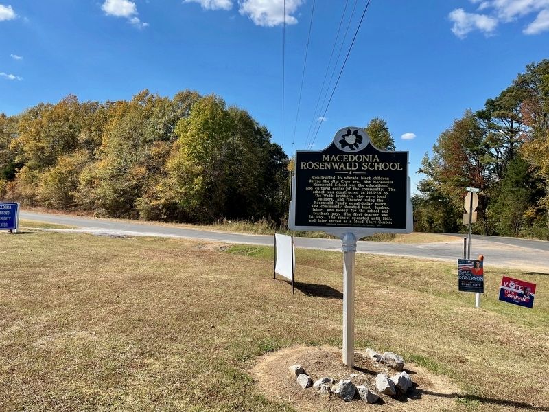
On Highway 343, 0.1 miles north of Bunker Hill Road (State Highway 1217), on the right when traveling north.
On Virginia Road (North Carolina Route 32) at Luke Street, on the right when traveling west on Virginia Road.
On Cameron Avenue, 0.1 miles north of East 12th Street, on the right when traveling north.
On Main Street (State Highway 37) 0.5 miles south of Alternate U.S. 158, on the left when traveling south.
On Mount Olive Drive (State Road 1555) 0.2 miles south of Long Ridge Road, on the left when traveling south.
On West Bank Street west of Grim Street, on the right when traveling west.
On Tingen Road south of James Street, on the right when traveling south.
On Humie Olive Road (State Road 1142) west of Evans Road (State Road 1147), on the left when traveling west.
On West Jones Street east of Lawrence Street, on the left when traveling east.
On Stinson Avenue, 0.1 miles east of Grigsby Avenue, on the left when traveling east.
On Method Road south of Richward Place, on the right when traveling south.
Paid Advertisement
On Cherry Road, 0.1 miles south of Ambrose Road, on the right when traveling west.
On Lincoln Heights Road, 0.2 miles south of Grinton Avenue, on the right when traveling south.
On North Chestnut Street south of East 10th Avenue, on the right when traveling north.
On Hampton Avenue Northeast at Kershaw Street Northeast, on the right when traveling east on Hampton Avenue Northeast.
On North Live Oak Drive (U.S. 17), on the right when traveling north.
On Main Street (State Highway 6) at U.S. 52 on Main Street.
On Russellville Road (State Highway 8-18) at Cedar Drive, on the left when traveling west on Russellville Road.
On West Broad Street just north of West Carolina Avenue, on the right when traveling south.
On Centerville Road, on the right when traveling north.
On Liberty Chapel Road, on the right when traveling east.
On Duckett Street at Mount Zion Drive (County Road 89) on Duckett Street.
On Moore Street east of Cook Street, on the right when traveling east.
On Woodruff Road, 0.1 miles south of Granary Drive, on the right when traveling south.
On Cedar Street at Lewis Street, on the right when traveling west on Cedar Street.
On State Highway 707, 0.2 miles south of McDowell Short Cut Road (State Highway 477), on the right when traveling north.
Paid Advertisement
On 10th Avenue North at Carver Street, on the right when traveling east on 10th Avenue North.
On West Mill Street east of Pleasantview Drive, on the right when traveling west.
On Hope Station Road near Peak Road (South Carolina Highway 36-33), on the right when traveling south.
On 150 Pleasant Hill Circle, in the median.
On Bowman Branch Hwy (State Highway 210), on the right when traveling west.
On Norway Road (County Highway 332) 0.3 miles west of Trojan Street (County Highway 2218), on the right when traveling west.
On Geathers Street east of Desaussure Circle, on the right when traveling east.
On Neeses Highway (State Highway 4) near State Rd S-38-1695 (State Highway 38-1695), on the right when traveling west.
On Piney Woods Road (State Highway 40-674), on the left when traveling south.
On Broad River Road (U.S. 176), on the right when traveling north.
On Ridge Hill Drive at Williams Avenue, on the left when traveling east on Ridge Hill Drive.
On Tinker Creek Road at Mattie Drive, on the right when traveling east on Tinker Creek Road.
On Steele Street (State Highway 270) just south of Avery Street, on the right when traveling south.
On Harris Street at Jackson Street, on the left when traveling north on Harris Street.
On Steekee Road at West Street, on the right when traveling north on Steekee Road.
On North Cedar Avenue (Tennessee Route 27) south of Old Jasper Road, on the right when traveling south.
Paid Advertisement
On Southport Road at Rainey Street, on the right when traveling west on Southport Road.
On South Highland Avenue at Ash Street, on the left when traveling south on South Highland Avenue.
On A D Washington Parkway, 0.2 miles Mason Tucker Drive, on the left when traveling west.
On N. Manasass Street just south of Wells Ave..
On Dallas Street, 0.1 miles north of Park Avenue, on the right when traveling south.
On Wheatley Street, 0.1 miles south of Martin Luther King, Jr, on the right when traveling south.
On Old U.S. 31E south of U.S. 31E, on the left when traveling south.
On Zieglers Fort Road, 0.1 miles north of Cairo Road, on the left when traveling north.
On Small Street west of Magnolia Street, in the median.
On East Market Street at Ward Street, on the right when traveling west on East Market Street.
Near S. Broad St. close to E. Clay St..
On Flora St. at Arts Plaza on Flora St..
On State Highway 2919 near Powell Point School Road, on the left when traveling west.
On County Road 317 west of County Road 314, on the right when traveling east.
On State Highway 7, on the left when traveling west.
On Blake Manor Road at Union Lee Church Road, on the right when traveling north on Blake Manor Road.
Paid Advertisement
On St John Road (Virginia Route 640) 1 mile south of Gordonsville Road (Route 231), on the right when traveling south.
On Virginia Route 39 at T. C. Walker Road (County Route 635), on the left when traveling west on State Route 39.
On Main Street (County Route 615) just east of Pinehurst Heights Road (County Road 616), on the right when traveling west.
On Brunswick Drive (County Route 644) at Exit 24 (Interstate 85) on Brunswick Drive.
Near Camden Street (Virginia Route 1001) 0.1 miles south of Hancock Street (Virginia Route 1001), on the left when traveling south.
On North Madison Road (U.S. 15) at South Constitution Route (State Highway 20), on the right when traveling south on North Madison Road.
On Village Highway (Virginia Route 24) just west of Red House Road (County Road 615), on the right when traveling west.
Near The Glebe Lane (Virginia Route 615) 0.1 miles west of Ruthville Road (Virginia Route 612).
On Virginia Route 5 at Virginia Route 619 on State Route 5.
On Thomas Jefferson Highway (Route 47) north of Union Cemetery Road (Virginia Route 709), on the left when traveling north.
On Cargills Creek Road (County Route 632) at Salem School Road (County Route 608), on the right when traveling west on Cargills Creek Road. Reported permanently removed.
On Cargills Creek Road (County Road 632) just west of Tobacco Hill Road (County Road 608), on the right when traveling west.
On Westfield Road just west of Railroad Avenue, on the left when traveling west.
Near Cartersville Road (Virginia Route 45) 0.1 miles north of Ampthill Road, on the right when traveling north.
On Ruffin Street just east of North Main Street (U.S. 301), on the left when traveling east.
On George Mason Boulevard at School Street, on the left when traveling south on George Mason Boulevard.
Paid Advertisement
On Rectortown Road (County Route 710) 0.3 miles north of Frogtown Road (Virginia Route 702), on the left when traveling north.
On Alexandria Pike (Business U.S. 15/211) at North Street, on the right when traveling north on Alexandria Pike.
On T C Walker Road (Virginia Route 629) 0.1 miles south of Seawell Avenue (Virginia Route 1411), on the left when traveling south.
On George Washington Memorial Highway (U.S. 17) 0.5 miles north of Ernest Lane (Virginia Route 667), on the right when traveling south.
On Old Mill Road, 0.2 miles east of Cardwell Road (Virginia Route 670), on the right when traveling west.
On Hadensville-Fife Road (Virginia Route 606) north of Chimney Springs Drive, on the right when traveling north.
On Chatsworth Road, 0.1 miles north of New Market Road (Virginia Route 5), on the right when traveling north.
On Main Street (Business U.S. 258) at Church Manor Trail, on the right when traveling south on Main Street.
On King William Road (Route 30) south of Walkerton Road (Virginia Route 629), on the left when traveling south.
On Diamond Street at Maury Street, on the left when traveling east on Diamond Street.
On Three Chopt Road (Virginia Route 634) 0.1 miles west of Broad Street Road (U.S. 250), on the right when traveling west.
On Jefferson Highway (U.S. 33) east of School Bus Road (County Route 767).
On K-V Road (Route 40) just east of School Road (Virginia Route 707), on the right when traveling east.
On Concord Turnpike at Spinoza Circle, on the right when traveling north on Concord Turnpike.
On Liberty Street north of Grant Avenue (Virginia Route 234), on the right when traveling north.
On Church Street East (Business U.S. 58) at Boden Street, on the right when traveling east on Church Street East.
Paid Advertisement
On Church Street (Virginia Route 611) just south of Put-In-Creek Road, on the left when traveling north.
On East Virginia Street east of South Mecklenburg Avenue.
On General Puller Highway (Virginia Route 33) 0.5 miles east of Union Park Road, on the right when traveling west.
On East Main Street (U.S. 11) at North Franklin Street, on the right when traveling west on East Main Street.
On Old Cape Charles Road (County Route 641), on the right when traveling south.
213 entries matched your criteria. Entries 101 through 200 are listed above.
⊲ Previous 100 —
The final 13 ⊳