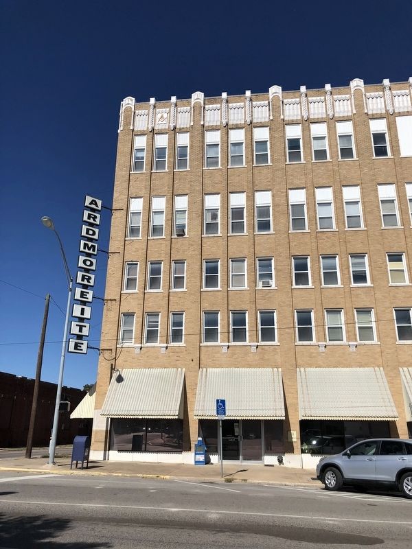
This building, originally built in 1930 by
architect J.B. White, was called the
Gilbert Building. It was renamed the
Ardmoreite Building in 1966 when it
became the home of The Daily
Ardmoreite. Between 1930 and 1966
many businesses . . . — — Map (db m142416) HM
Carter County was created in 1907 from part of the old Chickasaw Nation. Pickens County was renamed Carter County in honor of Ben Carter, prominent Native American of the Chickasaw Nation. Members of the Constitutional Convention chose Ardmore as . . . — — Map (db m286796) HM
This park was created between 1933 and 1940 by members of Civilian Conservation Corps Companies 1813 and 849, two of many organized by the federal government during the Great Depression. To provide useful employment for thousands of young men . . . — — Map (db m212797) HM
Daubes’ Department Store was a long time landmark on Main Street of Ardmore.
The original Daube Store was opened in Bowie, Texas, in 1883, and was owned by Sam Daube.
In about 1888, when the Ardmore area was in Pickens County, Indian . . . — — Map (db m142482) HM
The construction of this courthouse was
financed in 1898 by two private
entrepreneurs, Joe F. Robinson and
A. V. Doak. The building was leased to the Federal
Government and the court was presided over by
Judge Hosea Townsend. This fourth . . . — — Map (db m142411) HM
Before statehood in 1907 Lewis Robert Marston began laying sidewalks in Ardmore, I.T. Before 1907 Mr. Marston poured the first sidewalk around what would become the Carter County Courthouse in 1910. This piece of concrete is from the original . . . — — Map (db m286798) HM
A Methodist college once stood here. Begun by the City of Ardmore it was given to the Indian Mission Conference of the Methodist Church. Named in honor of Bishop Robt. K. Hargrove. In 1907 the school burned but was rebuilt north of the city. It . . . — — Map (db m141620) HM
The Hotel Wisnor, named in honor of Benjamin Wisnor Carter, prominent Chickasaw citizen, was built on this site in 1884 and was the first and finest establishment of its kind in Indian Territory. The three-story building of brick and stone had 50 . . . — — Map (db m142485) HM
In 1893, E.B. Luke came to Ardmore, Chickasaw Nation, from Detroit, Michigan. At the time, his brother, Jack Luke, operated a music and school book store in Oklahoma City, and urged E.B. to open this same type of store in Ardmore. So in 1895, E.B. . . . — — Map (db m142420) HM
On April 19, 1895 a fire broke out in Harper’s Caddo Street Livery Stable. It quickly spread and consumed six blocks of East Main Street from the Santa Fe Railroad tracks to Washington (then known as Springer Street). Eighty-six businesses were . . . — — Map (db m142489) HM
The Noble Brothers, Sam and Ed, arrived in Ardmore, Chickasaw Nation, in 1893, from Oakland Prairie, Pickens County, after a brief sojourn in Pottsboro, Texas, where they were partners in a general merchandise business and operated a ferry crossing . . . — — Map (db m142481) HM
Before 1899, J.W. Banks built, at this site, a mercantile establishment combined with lodging quarters. In 1903, W.F. (Dixie) Gilmer arrived from North Carolina and leased the hotel which was a three story structure with rooms on the second and . . . — — Map (db m142422) HM
Built in 1918, the Simpson Building was Ardmore's first attempt at building a skyscraper office building. B. A. Simpson, P. C. Dings, and Roy M. Johnson, all of Ardmore, financed the building's construction. The building's first floor facade was . . . — — Map (db m287097) HM
On November 9, 1905 Mattie Dobbins purchased this lot from the Chickasaw and Choctaw Nations for the sum of $252.60. Ms. Dobbins entered into a 10 year lease contract with the Banker's Trust Co. on July 31, 1906 for a $50.00 per month rental on the . . . — — Map (db m286797) HM
Two years after the City of Ardmore was founded, the First National Bank & Trust Company of Ardmore began as a private bank in 1889 by J. F. Anderson and his son, Charles. Within a year, a national charter was granted, giving the bank the honor of . . . — — Map (db m282382) HM
The original Whittington Hotel was opened on the corner of Caddo and Main Street in 1891. It was rebuilt with brick and sandstone following Ardmore’s Great Fire of 1895. It had the town’s first metal-cage Otis elevator. The hotel was closed in 1965 . . . — — Map (db m286898) HM
Rosella Hightower
The world renowned ballerina was born 1/20/1920 on Wolf Creek 2 miles south and ½ mile east (C SW SE SE Sect. 34, 3E 4S). She became the prima ballerina of the Ballet Russe de Monte Carlo, the original Ballet Russe, the . . . — — Map (db m147485) HM
March 14, 1943 Aeronca L-3C Grasshopper
Emil M. Horkavi Gary, Indiana • Frank M. Dimond Wilmington, California
November 4, 1943 B-17 Flying Fortress
Derald C. Holland, Santa Ana, California •
Lee R. Woodall Jr. El Dorado, Arkansas • . . . — — Map (db m209383) WM
Production of crude oil from the newly-discovered Healdton field surrounding this marker site flooded the marker with an oversupply of petroleum protesting that pipeline purchases were inadequate. Producers claimed they were being deprived of . . . — — Map (db m180600) HM
WW II CO Co K 152nd Inf 38th Inf Div
Wounded in Philippine Islands May 16, 1945
Korea CO Tank Co 179 Inf Reg 45 Inf Div wounded May 6, 1952
Distinguished Service Cross
Distinguished Service Cross by direction of the President under the . . . — — Map (db m180534) HM WM
The All-Black towns of Oklahoma represent a unique chapter in American history. No where else, neither the Deep South nor the Far West, did so many African American men and women come together to live in and govern their own communities. By 1920, . . . — — Map (db m284940) HM
A bond issue totalling $454,323.56 was voted on by the taxpayers of Coal County to construct a new courthouse. The bond was issued on June 1, 1968 and was supported by a tax levy of 1/2 mil. the debt was paid for on June 1, 1990.
Architect . . . — — Map (db m181749) HM
This bridge dedicated to Sergeant John O. Linton, Coalgate, Oklahoma, wounded and captured in action on 30 December 1943 in Italy during the Naples-Foggia Campaign in WWII while member of Company M, 3rd Battalion, 180th Infantry Regiment, 45th, . . . — — Map (db m264209) WM
From his hometown of Maysville, Oklahoma, he explored the skies.
In 1933, this self-taught scientist became the first person to fly solo around the world to prove flying safe.
The pressurized flight suit he designed and developed and high . . . — — Map (db m284937) HM
Freedom Is Not Free
In honor of all Garvin Countians who sacrificed their lives while serving our country in time of war, for it is only through the efforts of those who served, and those who died, that America enjoys the freedom and prosperity . . . — — Map (db m121754) WM
By 1916, plans were underway to promote a network of roads through Oklahoma called the "Ozark Trail". The trails were planned by the Ozark Trail Association. Its mission was to promote a system of better roads connection the surrounding states. . . . — — Map (db m179893) HM
In 1892 the Rock Island Railroad was continuing its expansion, and the rails were extended seventeen miles south of Minco where a siding was built. A boxcar was set on the siding to serve as an office, and Chickasha was born. The following years . . . — — Map (db m284927) HM
A Comanche band near the village was attacked by Capt. Earl Van Dorn, with 4 companies of 2nd Cavalry, Oct. 1, 1858. Unknown to him, the Indians were on way from friendly council with officers at Ft. Arbuckle. In the furious fight, 70 Indians were . . . — — Map (db m181528) HM
This M110A2 was donated to post 176 in 1996. It could fire a 175mm round up to a distance of 18 miles. The M110A2 proved itself as effective in a wide variety of environments, including the jungles of the Vietnam War, the U.S. military would also . . . — — Map (db m287678) HM
Canadian River was south line of "Old Oklahoma" opened by Run of April 22, 1889, at 12 o'clock noon. At this hour, riders forded the river crossing near Silver City (north 2 miles) on the Chisholm Trail, and entered the wide, new land to stake . . . — — Map (db m287677) HM
Site of Silver City trading post, first school, and pioneer burying ground, two miles north.
Dedicated to ranchmen, cowboys, early settlers, and their descendants.
2nd Plaque
Names of Silver City Pioneers First Settlement in the . . . — — Map (db m287679) HM
In recognition of heroism involving voluntary risk of life as firefighters with the 82d Civil Engineering Squadron, Sheppard Air Force Base, Texas, on 11 June 1995. Mr. Richard A. Hogan and A1C Christopher M. Rezac with complete disregard for . . . — — Map (db m142274) HM
Chisholm Trail Lookout Point
This site was given by Henry and Blanche Price in honor of the Pickens County Cowpunchers Association and all other cowboys and pioneers that used this trail
Replaced March 2007 Oklahoma Centennial . . . — — Map (db m142229) HM
Opened October 28, 1907,
under auspices of
Comanche and Mullins
Baptist Associations
Ownership passed to
Baptist General Convention
of Oklahoma, 1910.
Moved to Mangum, 1912, Closed 1915. — — Map (db m119790) HM
In 1912, Jake L. Hamon, a wildcat speculator, proposed the idea of a railroad from Ardmore to Lawton via southern Oklahoma to John Ringling, owner of the famed Ringling Brothers Circus. Land west of Ardmore was acquired that connected to townsite . . . — — Map (db m286900) HM
This is the only county seat on the 98th Meridian in Oklahoma. Townsite, west side of line, was in Kiowa-Comanche Reservation opened to settlement on Aug. 6. 1901. Moneka was the post office, established 1895, on east side of line, in Pickens Co., . . . — — Map (db m181531) HM
This property has been placed on the National Register of Historic Places by the United States Department of the Interior May 2002 Restored by Friends of the Depot — — Map (db m298900) HM
Douglas H. Johnston was elected Chickasaw Governor for two terms (1898-1902) he built this house in 1895. It is located on the northwest edge of Emet 10 miles southeast of Tishomingo built on a foundation of bois d'arc blocks. Oak beams were laid . . . — — Map (db m201699) HM
Oklahoma's first corn club of 50 boys, forerunner of today's 4-H program, was organized at Tishomingo in 1909 under the direction of W.D. Bentley, father of extension work in Oklahoma.
In 1910, tomato canning clubs were formed for girls. Fifty . . . — — Map (db m184347) HM
Born on June 3, 1939 to Elvie E.. and Cleo P. Tolbert, Johnston County, Okla. Smokey was assisted by Congressman Carl Albert in gaining an appointment to the US Naval Academy and graduated with the class of 1962. He was the first US Naval Academy . . . — — Map (db m184305) HM
Construction began April 1898 on the Chickasaw Capitol Building. A stately structure overlooking the town of Tishomingo, it was built of red granite from the Pennington Creek Quarry of Gov. R.M. Harris. Granite blocks weighing 175 lbs. per cubic . . . — — Map (db m184446) HM
About 1859, the Chickasaw government purchases an iron bell to be hung in the first Chickasaw Capitol Building. It was used to summon tribal members to special meetings and to signal emergencies in the community. Depending on the type of ring made . . . — — Map (db m188156) HM
The greatest and last full blood Chickasaw warrior. Chief Tishomingo (Joe Factor) was born near Chickasaw old fields about 1735. Chief counselor and national orator of the Chickasaw Nation, his words were recognized as law. He was the principal . . . — — Map (db m184451) HM
From our migration to what is now Mississippi, Kentucky, Alabama and Tennessee in prehistoric times, to our new homeland in south central Oklahoma in the mid 1800's, the Chickasaw have always had roots in nature and the elements. With the spirits of . . . — — Map (db m181703) HM
The history of the Johnston County Courthouse dates back to the beginning of Oklahoma statehood, November 16, 1907 when counties were formed. One of the 77 Oklahoma counties formed, Johnston County, needed a place to operate governmental business. . . . — — Map (db m184348) HM
The memorial consists of an arched entry way with a sidewalk flanked on each side by memorial bricks leading into a circular walkway placed along the back side of the walkway. There are five granite monuments one each for World War I, World War II, . . . — — Map (db m184278) WM
Dedicated to All the Men and Women of Johnston County Who Have Served as Members of the Armed Forces of the United States of America With Honor and Valor That We May Enjoy Peace and Freedom — — Map (db m188037) WM
Samuel E. Akins • Homer R. Armstrong • Clyde Bass • Guy A. Blalock • John A. Butler • Claude F. Darter • James D. Davis • William Ceasley • Joseph Sedmonds • Newton M. Ellis • Sampson Ensharkey • Marion C. Fite • Samuel P. French • Joe B. Gibson • . . . — — Map (db m187846) WM
Leonard "Skinny" Allen • Billy Ames • Willie Lee Anderson • Melvin Arnett • Fred Bean • David A. Bettinger • Eugene Bradley • Russell O. Bradley • Dewitt Brawley • John Lewis Chisolm • Clinton B. Clifton • William L. Coffman • Amos Conley • Roy R. . . . — — Map (db m187867) WM
After the Chickasaw Nation officially vacated the Capitol in 1910, many changes took place on the grounds. Eventually, the exact location of the well became somewhat of a mystery.
In July of 2004, workers who were repairing the roof on the . . . — — Map (db m188048) HM
Struggling farmers united to form farmers union at Point, Texas, in 1902. Spreading into the twin territories, future statesman William H. "Alfalfa Bill" Murray helped establish the Indiahoma Farmers Educational and Co-Operative Union of America. . . . — — Map (db m184323) HM
Pennington Creek, a small tributary formed from springs in central Johnston County, provides enormous benefits to Oklahoma as it flows toward Lake Texoma. The waters of Pennington Creek nurture precious life of hatching fish at Tishomingo National . . . — — Map (db m184270) HM
This statue is a representation of Piominko, who served as a Chickasaw leader from approximately 1783-1799. Prior to being our Piominko, his name is believed to have been Tushatohoa. Piominko led the Chickasaws during a pivotal time in our history, . . . — — Map (db m184434) HM WM
"I pledge you by those peaks of snow as long streams to ocean flow long as years their youth renew peace shall reign between us two."
Alexander L. Posey Creek Indian Poet
"It's comin' yet for a' that that man to man the world . . . — — Map (db m188065) HM WM
Congressional Medal of Honor Recipient
For conspicuous gallantry and intrepidity at the risk of his life above and beyond the call of duty as commanding officer of the U.S.S. LSC(L)(3)-122. During operations against enemy Japanese forces in . . . — — Map (db m188220) HM WM
This is the original location of the Capitol Well.
In the 1890's, the Chickasaw National Jail and Jailor's home were located on the Capitol grounds. The National Jailor had many responsibilities aside from his duties as Jailor. It was his job to . . . — — Map (db m188046) HM
Built in the 1890's, the National Jail and jailor's home (shown in photograph below) were located north of the Capitol Well. Although the Chickasaw Constitution established the National Jail in 1857, it is unclear where prisoners were held prior to . . . — — Map (db m188062) HM
Capital of the Chickasaw Nation which was organized in 1856, under a written constitution. Named for revered Chief Tishomingo who had died on the Trail of Tears during Indian Removal from Mississippi. Last Chickasaw Governor was Douglas H. . . . — — Map (db m203086) HM
Site of home and grave 1 mile south-east on Graveyard Bluff. Born 1789, migrated with Chickasaw from Mississippi in 1837. First elected Chickasaw chief in Indian Territory. Pickens County named for him. As a Chickasaw Commissioner, signed Treaties . . . — — Map (db m284944) HM
Love County has a rich historical significance to Oklahoma and the nation. Carved from the Louisiana Purchase and acquired from the Choctaw Nation by the Chickasaw Nation, the county was named for the Loves, a prominent Chickasaw family. Early . . . — — Map (db m121634) HM
Oklahoma's first county courthouse built after Statehood. The corner-stone of Nelson Georgia marble was laid during Masonic ceremonies on April 29, 1910. The building was dedicated on November 24, with Senator J. Clint Graham presiding. The building . . . — — Map (db m121635) HM
(front)
-U.S.A.-U.S.N.-U.S.A.F.-U.S.M.C.-M.M.-
Dedicated to the men and women of the Orr community who served our country in times of peace and war
Roy Carroll ∙ Lavern Hodgson ∙ Razz Black ∙ George G. W. Power . . . — — Map (db m57441) WM
Named for Gen. Henry Leavenworth who died near here July 21, 1834 while enroute from Ft. Gibson to Wichita Village in western Oklahoma for a peace conference with the Plains Indians. The expedition continued under Col. Henry Dodge, assisted by many . . . — — Map (db m141412) HM
Established 1854 by Chickasaw Council, Daugherty Colbert, Chief; David Burney, Joel Kemp, George D. James. A.V. Brown, school trustees. Opened as school for Chickasaw girls 1859, under supervision of Cumberland Presby. Bd., Rev. Robert S. Bell and . . . — — Map (db m284918) HM
for conspicuous gallantry and intrepidity at the risk of his life above and beyond the call of duty in action with the enemy:
Sergeant Burris, Infantry, United States Army, a member of Company L. 38th Infantry Regiment, distinguished himself by . . . — — Map (db m284981) HM WM
On November 16, 1907, Purcell’s children celebrated Oklahoma’s entry into statehood by forming a human “star” in the downtown. This symbolized Oklahoma’s role as the 46th star in the U. S. flag ★
Dedicated to Purcell . . . — — Map (db m144747) HM
Erected by the members
Mrs. Stonewall Jackson Chapter,
No. 550 U. D. C.
of Purcell Ind. Ter. Dec. 1906
To the memory of
those who
fought and
those who fell
in the
Confederate Army
1861—1865
But their memories ever . . . — — Map (db m144840) WM
Michael A. Adams · James Ayers · Terry Blount · Mark Bradley · Paul Bradley ·
Mickey Baker · Buck Branum · Tony Burleson · Jeff Burton · Mike Combest · Curtie Compton · Mark Corley · Larry Coulter · Billy Delaney · Robert D. Dillard · Mike Eaton . . . — — Map (db m144824) WM
The inter-territory statehood convention, the first to advocate single statehood for Oklahoma and Indian Territories, met on September 30, 1893 in Purcell's Methodist Episcopal Church, south at approximately 319 W. Washington. Delegates from both . . . — — Map (db m121632) HM
The James C. Nance Bridge is a stellar example of the bridge building that
took place in Oklahoma under the auspices of the many federal aid
programs that made up the New Deal. This bridge combined funds made
available through the Federal Aid . . . — — Map (db m276525) HM
Caravans of gold seekers in the Rush for California traveled this Trail in spring, 1849, under military escort commanded by Capt. R.B. Marcy. Route lay west from Ft. Smith, south side of Arkansas and Canadian rivers, across Oklahoma. Camp ground . . . — — Map (db m144810) HM
Established 1904 Indian Territory Richard Bawden Hutchins Proprietor Funeral Director & Embalmer Minnie Laura Cox Hutchins Wife & mother of seven Thamazin, Gladys, Alfred, George, Joe, Dorothy & R.B. First licensed lady embalmer in the state of . . . — — Map (db m207506) HM
Oklahoma is the birthplace of reflection seismic technique of oil exploration. This geophysical method records reflected seismic waves as they travel through the Earth, helping to find oil-bearing formations. It has been responsible for the . . . — — Map (db m284920) HM
This historical monument is a gift honoring the young men of Civilian Conservation Corps Company 808 who contributed a major part to the building of this beautiful park. They defended, protected and preserved our nation's natural resources for all . . . — — Map (db m195042) HM
Springs in this area were first used by wildlife, Indians, and cattlemen. In 1902, Sulphur Springs Reservation was founded, renamed Platt Nat'l Park in 1906, and became part of Chickasaw Nat'l Rec. Area in 1976. The town was moved twice to its . . . — — Map (db m121633) HM
Ada, Indian Territory was founded on lands acquired from Chickasaw and Choctaw citizens. The U.S. Government forcibly removed the Chickasaw and Choctaw Nations to this area from their southeastern homelands. The town began in 1890 when William . . . — — Map (db m179659) HM
Water is the lifeblood of a community. Flowing from deep within the gently rolling hills of South Central Oklahoma. Byrds Mill Spring has for centuries provided these life-giving waters. Native Americans long ago recognized the importance of the . . . — — Map (db m179725) HM
World War I
Orba M. Allen • Willard V. Allford • Huey Armstrong • Peroy O. Barton • Floyd W. Belt • Jesse J. Bennett • John B. Bishop • Christopher L. Bradley • William H. Brown • Willis O. Casey • Ernest Cassidy • Jasper D. Choate • Jess H. . . . — — Map (db m179557) WM
We honor these veterans who served to defend what we believe is right and remember the sacrifice of those who have gone before us. We are grateful for their service to protect our freedom. Secure civilization and ensure the survival of our . . . — — Map (db m179245) WM
The 1856 boundary between the Chickasaw and Choctaw Nations was east of this site. Each spring and fall the Indians from both Nations met here to race horses and play games. This site was perfect because of the good spring water that fed the area. . . . — — Map (db m64183) HM
Occupied 1834 by Chief Black Dog's Osage band on buffalo hunt. Gen. Henry Leavenworth and the First Dragoons, including officers Henry Dodge, S.W. Kearney, R.B. Mason, Jefferson Davis, Nathan Boone, and noted artist, George Catlin, camped here June . . . — — Map (db m64130) HM
In dedication to those who served in the defense of our nation and in the Armed Forces of the United States
1776 - 1976
Council Members
Jim Sanders
Louise Lindsey
Grady McCord
John Hodges — — Map (db m142695) WM
Dedicated to
the men and women
of the Armed Forces
who served their
country honorably
and who so nobly
gave their lives for
our country's
freedom
World War I Nathaniel H. Adair ∙ Henry A. Bibles ∙ Frank Bibles . . . — — Map (db m57782) WM
Side 1 - "Erected 1993 in memory of a man who left an indelible impression on Duncan and Stephens County. He touched the lives of many people not only as the county's largest employer but as a perpetually inquisitive person whose technical . . . — — Map (db m58430) HM
Main Marker: Halliburton
Incorporated July 1, 1924
Leading the Industry - Worldwide
Duncan and Halliburton Have Served
Each Other For 80 Years
Looking to a Great Future
Small Inset: This Halliburton rig was erected in . . . — — Map (db m58741) HM
For over 100 years, Halliburton has fostered a culture of unparalleled service to the world's energy industry.
Founded in 1919, Halliburton got its start in Duncan, Oklahoma, using the untested process of oil well cementing. Since those . . . — — Map (db m181861) HM
116 entries matched your criteria. The first 100 are listed above. The final 16 ⊳