Founded in 1682 By Don Antonio de Otermin and Padre
Fray Francisco Ayeta O.F.M.
for the civilizing and Christianizing of the Tigua Indians, Pueblo Revolt refugees, formally located at La Ysleta, New Mexico. Building damaged by floods of the Rio . . . — — Map (db m118313) HM
The present site of the Ysleta Neighborhood Health Clinic was part of the earliest Native American settlement associated with a Spanish Mission in the State of Texas, circa 1680 – 1750 A.D.
In 1989-1990, archaeologists conducted . . . — — Map (db m38088) HM
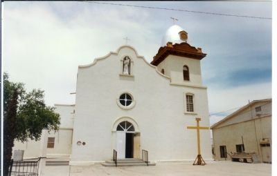
Site of the mission and pueblo of Nuestra Señora de la Concepción del Pueblo de Socorro established by Don Antonio de Otermín and Father Fray Francisco Ayeta, O.F.M. in 1683. Maintained by Franciscan missionaries for the civilizing and . . . — — Map (db m118295) HM
During the Pueblo Revolt of 1680, Gov. Antonio de Otermín and Father Francisco de Ayeta led Piro Indian and Spanish refugees out of New Mexico into this region, establishing a settlement they named Socorro after the home they had left. The town's . . . — — Map (db m201923) HM
In September, 1680, refugees fleeing the Pueblo Revolt assembled at La Salineta, a paraje - or stopping place - named for the salt deposits along the Rio Grande. Antonio de Otermin, a governor and captain-general of New Mexico, ordered a . . . — — Map (db m245297) HM
In 1837, Bailey Inglish moved his family to this area from western Arkansas, where he had been an influential leader of pioneer settlers. Here he was active in the formation of Fannin County, serving on the land board and later as chief justice. To . . . — — Map (db m128647) HM
Army supply headquarters for Northern Sub-District of Texas. Dispensed uniforms, clothing, blankets, harness, bridles, gear, saddles, food rations.
Beef, pork and wild game were cooked in an army mess kitchen furnace on this site.
At least 7 . . . — — Map (db m234003) HM
First settlement and fort In Fannin County. Built in 1836 by Abel Warren, Indian trader from Arkansas, to protect his trading post. Constructed of bois d'arc wood, the structure had a two-story guardhouse at all four corners. Kiowa, Tonkawa, Caddo, . . . — — Map (db m204489) HM
Born in South Carolina in about 1787, James
Jeffres Ross was a member of the ""Old Three
Hundred." He arrived in Stephen F. Austin's colony
in late 1822 or early 1823, moving onto the league
granted him near Eagle Lake in Colorado . . . — — Map (db m22753) HM
James Lyons (b. 1778) brought his family to Texas from New York in 1820. While working outside his cabin near this site on Oct. 15, 1837, Lyons was killed by Comanches. His was the first grave in this family cemetery. His 12-year-old son Warren . . . — — Map (db m163245) HM
From 1540 to 1542, Francisco
Vazquez de Coronado led the first
organized European exploration of
the southwest in search of the
fabled "cities of gold." With a
company of more than a thousand
men and women and thousands of . . . — — Map (db m25292) HM
Of all the confrontations between the United States Army and Indians in Texas, the Battle of Blanco Canyon is identified as one of the most decisive clashes in the U.S. cavalry’s campaigns against the Comanches. Indians inhabited the canyons and . . . — — Map (db m104808) HM
After being captured by Comanche Indians on May 19, 1836, in what is now Limestone County, Cynthia Ann Parker was recaptured here by Texas Rangers under Captain L.S. Ross on December 18, 1860 — — Map (db m170422) HM
In 1860 at the Battle of Pease River, Indian captive Cynthia Ann Parker and her daughter, Prairie Flower, were rescued by Texas Rangers under Capt. L.S. Ross (later Governor of Texas). Cynthia Ann, most celebrated of all Comanche captives, had . . . — — Map (db m170428) HM
Quanah Parker and the Comanches camped near here on the Pease River & Cynthia Ann recaptured 8 miles N.E.
Arrow Sculptor: Charles A. Smith — — Map (db m170434) HM
Ambrose Ripley and his wife Rachel (Wood) brought their family to Texas in 1837, settling near here in what was then Red River County. They established their home near the Nacogdoches Road (Cherokee Trace) and a stream now known as Ripley Creek. . . . — — Map (db m119349) HM
First public burial ground in community. Before its founding people were buried in private plots, church cemeteries, or in public graveyards outside this precinct. In 1896 Moses Veith deeded five acres of land for use as a community cemetery. . . . — — Map (db m162647) HM
Home of Pachal Indians before Spaniards arrived in Mexico (1519). First area explorer was Alonso de Leon, 1690, searching for Fort St. Louis founded by La Salle. Upper Presidio Road - Artery of travel from Saltillo, Mexico, to East Texas - . . . — — Map (db m162751) HM
The first recorded history of Galveston Island occurred in 1528 with the shipwreck of Cabeza de Vaca and his crewmen. They were survivors of Alvarez de Pineda’s ill-fated expedition to Florida and were held captive here by the Karankawa Indians. De . . . — — Map (db m239826) HM
In this area is one of several known Karankawa campsites or burial grounds. Now extinct, the nomadic Indians lived along the Texas coast, depending on the Gulf for survival. In 1528 they aided Spanish explorer Cabeza de Vaca, but resisted all . . . — — Map (db m201910) HM
Thin, triangular arrow points 2 to 4 centimeters long. Of fine workmanship, with central basal notch and deeply serrated edges, discovered and named here, site 41GR40, an archeological highway salvage dug in 1959 by South Plains Archeological . . . — — Map (db m174163) HM
Established in 1849 by Doss brothers. Operated 1859-1878 by William F. Lange; 1878-1888 by Julius Lange. Its products were famed throughout the region. One of the last of the old burr mills in Texas; one of few in as perfect a state of preservation. . . . — — Map (db m91745) HM
During Fredericksburg’s 150th anniversary, we celebrate the enduring friendship between the Comanche Nation and the people of Gillespie County.
We honor the Comanches who helped to create and preserve this relationship and their descendants . . . — — Map (db m94228) HM
This marl and limestone hill, elevation 1,915 feet, was an Indian signal point, advancing news of the intrusions of white settlers. The hill was first recorded and described by the German geologist, Dr. Ferdinand Roemer in 1847. A timber cross found . . . — — Map (db m71921) HM
Commissioner-General of the Society for
the Protection of German Immigrants in Texas
who became a citizen of the Republic of Texas
under the name of John O. Meusebach.
Founder of Fredericksburg on May 8, 1846.
On March 1-2, 1847, he . . . — — Map (db m35893) HM
To be a Texan, Meusebach gave up title of baron in 1845. As commissioner-general, German-Emigration Company, he founded Fredericksburg in 1846 as gateway to Fisher-Miller land grant, hunting ground of the Comanche. By emptying his firearms, he won . . . — — Map (db m91648) HM
John O. Meusebach, German settler and founder of Fredericksburg, and Penatuka Comanche chief, Santanna share a peace pipe on May 7, 1847, at the signing of the treaty between the People of Fredericksburg and the Comanche Nation. The standing . . . — — Map (db m35884) HM
Several bands of Comanche and Lipan Apache Indians lived in the region of Texas in which the Germans established Fredericksburg. Interaction between the German immigrants and the Native Americans was inevitable and potentially hostile. The . . . — — Map (db m118487) HM
Established by the United States Army
December 5, 1848
as a protection to travelers and
settlers against Indian attack.
Named in honor of Major Martin Scott,
Brevet Lieutenant Colonel,
5th United States Infantry,
killed at Molino . . . — — Map (db m126961) HM
Throughout the 1700s, the Comanche Indians continually thwarted the imperial efforts of the Spaniards, who moved north from Mexico in an attempt to claim the Great Plains. After horses entered Comanche culture, a company of Spanish infantry . . . — — Map (db m118469) HM
At the height of activity at Fort Martin Scott, the post accommodated up to three hundred soldiers. Of the fort’s twenty buildings, the sutler’s store was among the most important to the soldiers. The sutler was a civilian merchant, licensed . . . — — Map (db m118502) HM
Pioneer preacher Matthew Taylor and the families of his daughter and two sons moved here in 1863 from their homestead on the Llano River. They built a cabin on this site near the source of the Pedernales River. In August 1864, Matthew and his son . . . — — Map (db m59741) HM
From massive thundering herds to near extermination, the American bison remains a symbol of the American West.
Bison for Miles
At one point in our history, a large portion of the country was one giant bison range. It wasn't uncommon for . . . — — Map (db m236594) HM
These shaggy animals once roamed Texas in countless numbers and were the main source of food for the Plains Indians. The Comanches here hunted them on horseback but never killed enough to damage the herds. But commercial hunters moved in and . . . — — Map (db m236595) HM
The mission remains are not yet fully understood, but archeologists have determined how some of the structures were used.
A. First Chapel
The eastern side of the main structure is believed to have been the first chapel, constructed . . . — — Map (db m235456) HM
Struggling to overcome cultural differences, the Spanish and native inhabitants of the Texas missions forged connections that would alter the course of Texas history.
Conflict and Cooperation
When the first missionaries arrived, South . . . — — Map (db m235452) HM
Originally established near present Matagorda Bay, Mission Nuestra Señora del Espíritu Santo de Zuñiga was moved to this San Antonio River location in 1749. Here, for more than 70 years, the Franciscan missionaries taught the native Aranama peoples . . . — — Map (db m235186) HM
Founded in 1754 for the Cujane Indians. Capt. Manuel Ramirez de la Piszina, commander of nearby Presidio la Bahia, named this mission for his parish church in Spain, and Fray Juan Dios Camberos ministered to the first converts here. The Indians . . . — — Map (db m132016) HM
Missionaries from the college of Nuestra Señora de Guadalupe de Zacatecas founded Nuestra Señora del Rosario in 1754 for the coastal Karankawa tribes. The extensive cattle ranching operation begun by sister mission Espiritu Santo also supported . . . — — Map (db m34287) HM
Though today you may only see stone foundations, this was once the site of a lively mission community.
From Glory to Ruins
Ahead of you are the remains of the Spanish Mission Nuestra Señora del Rosario. Established in 1754 to bring . . . — — Map (db m235459) HM
Established in 1754
for the Cujane Nation.
Here faithful Franciscan
missionaries attempted to
Christianize and civilize
the Indians of the region
until 1794. — — Map (db m34284) HM
First established at the site of La Salle's Fort on Garcitas Creek, Victoria County, among the Coco, Cujanes, Karankawa and other Indian tribes in 1722. Moved to Mission Valley, Victoria County, on the Guadalupe River among the Jaranames and . . . — — Map (db m68955) HM
Stone Quarried Long Ago by Mission Indians and then again in modern times by the Civilian Conservation Corps has given life - and new life again - to Espíritu Santo. The kiln ceased its work generations ago, but it still stands as sentinel to . . . — — Map (db m235215) HM
In the Spanish colonization system, houses built outside the presidio fort walls by civilians and soldiers' families were intended to become a center of settlement. A diverse population - Spanish, Indian, African and European - flourished around the . . . — — Map (db m235136) HM
In April 1825, Green DeWitt acquired a land grant from the Republic of Mexico to settle 400 families in and around the present location of Gonzales. He recruited ex-Missouri state senator James Kerr as his surveyor general to establish a capital . . . — — Map (db m179326) HM
Native American raids were a major concern of DeWitt's Colony, which settled in this area after its 1825 establishment. To protect the colonists, Green DeWitt built a fort in Gonzales and requested troops and a cannon from Mexican authorities. In . . . — — Map (db m167419) HM
Native Americans and military forces have long camped at nearby springs that served as an oasis in the surrounding area. In 1852, U.S. Capt. Randolph B. Marcy led an expedition in search of the Red River headwaters, and his party camped here on . . . — — Map (db m154112) HM
Ten miles southwest of here Lieutenant Frank D. Baldwin commanding two companies of United States troops attacked a large band of Cheyenne Indians and rescued two white girl captives, November 8, 1874. — — Map (db m239511) HM
Comanches & other tribes followed
old trails ridge that became mail
route, railroad, route 66 & I-40.
Arrow sculptor: Charles A. Smith
— — Map (db m228335) HM
1872-74, Comanche, Kiowa & Cheyenne fought U.S. Army in series of battles on lands in present-day Gray county
Arrow sculptor: Charles A. Smith — — Map (db m154110) HM
Comanche, Kiowa & Cheyenne fought Red River War Battles nearby, seen in White Deer Land Museum exhibit.
Arrow sculptor: Charles A. Smith — — Map (db m155148) HM
On Sept. 29, 1872, Col. Ranald S. MacKenzie (1840-89) found in this area a 262-tepee village of Comanches defying treaties that sought to confine them on Indian Territory reservations. MacKenzie's 231 U.S. Cavalry and Infantrymen captured the . . . — — Map (db m228328) HM
Established about 1837 for trade with the Indians of the Red River region and the western plains. Here many white captives of the Red Men were redeemed. From its vicinity the Snively Expedition set out for New Mexico on April 25, 1843. Abandoned . . . — — Map (db m223626) HM
Also known as New Danville, this rural community was established around 1847, and reportedly named by S. Slade Barnett and family in honor of their former hometown of Danville, Kentucky. Located along the intersection of major roadways to Marshall, . . . — — Map (db m138890) HM
In 1821 near this site, Cherokee Indians blazed a trail from near Nacogdoches, Texas, to their home reservation at White River, Ark. They slashed trees, cleared path, planted "Cherokee" roses, and established camps at springs.
Used by Sam . . . — — Map (db m139093) HM
Named for North and South Bedias creeks, which in turn were named for the Bidai Indians, an agricultural people reputed to have been the oldest inhabitants of the area. "Bidai" means "brushwood", which may refer to the building material used in . . . — — Map (db m171440) HM
Originally an Indian trail through southern Texas and Louisiana; known to Spanish explorers as early as 1690, when the De Leon Expedition passed this site on the way from Mexico to East Texas.
With 115 men, 721 horses, 82 loads of flour, and . . . — — Map (db m213702) HM
Following La Bahia Road, Washington Avenue through downtown Navasota was a main section of the early road connecting the western settlements of Washington-on-the-Brazos and Goliad to the Grimes County seat of Anderson to the east and on to . . . — — Map (db m213691) HM
Founded in 1867 in connection with the Oakland Baptist Church which stood here until moved to Roans Prairie in 1913. Graves of many pioneers are located here.
Oakland was once a popular way-station for the Bates and Black Stagecoach Lines, . . . — — Map (db m199314) HM
The Comanches and other tribes traveled Blackwater Draw, 3 miles west of Abernathy, through 1874.
Arrow sculptor: Charles A. Smith — — Map (db m155152) HM
Stretching onward toward the sunset, o'er prairie, hill and vale, far beyond the double mountains winds the Old MacKenzie Trail.
Ah, what thoughts and border memories does that dreaming trail suggest; thoughts of travelers gone forever to the . . . — — Map (db m91267) HM
Quanah Parker and Comanches used Field's Crossing over Prairie Dog Town Fork of Red River by Memphis
Arrow sculptor: Charles A. Smith — — Map (db m152658) HM
Quanah camped at Deep Lake NE of Turkey & Kwahada grazed horses on Wolf Flat watered by Turkey Creek
Arrow Sculptor: Charles A. Smith — — Map (db m200482) HM
Described as a stout lady with an engaging personality, Elizabeth (Ann) Whitney confirmed that she could be strong, brave, and resourceful on one fateful July day in 1867. Ann was a teacher at a nearby frontier school. Suddenly, during the course . . . — — Map (db m177603) HM
Elizabeth (Ann) Whitney, a native of Missouri, accepted a teaching position at a newly erected rural school located about seven miles north of present day Hamilton in 1867. This school, called the Leon River School, was situated on a rise . . . — — Map (db m175572) HM
Congregation formed by local settlers in 1850s. First known pastor was the Rev. J.H. Perry, in 1870. Among early members were families of Isaac Steen, J. Hogue Pierson, J.A. Eidson, Thomas Dean, and Dr. George F. Perry.
Pioneer ministers of . . . — — Map (db m175672) HM
Early inhabitants of this area were Comanche and Kiowa Indians whose campsites were situated around four dolomite hills called Medicine Mounds and known for their healing properties. In 1854, area land was deeded to a railway company. Anglo settlers . . . — — Map (db m98594) HM
Quanah Parker, man of vision, fought against all odds to save the Comanche way of life. Then, he fought to survive and prosper in a white man's world. His mother, a white woman captured by Indians at age nine, was raised a Comanche. When Quanah was . . . — — Map (db m96820) HM
Attakapas and Akokisa Indians began to disappear from Harris County in the mid-1800s with the arrival of Anglo settlers. The first documented settlers in the Cypress area were the Burnett and Simmons families, beginning by 1831. Matthew Burnett . . . — — Map (db m197289) HM
A distinct ethnic cultural group, “Creoles of Color”, developed in Louisiana in the 18th and 19th centuries with roots in French, Spanish, African and Native American cultures, they spoke standard or Creole French and practiced Catholicism. Free . . . — — Map (db m235851) HM
Karankawa Indians hunted buffalo on this site as late as the 1820s. Present Fifth Street follows the course of the San Felipe Road, which was opened to Austin's colony in that decade. In 1836 Santa Anna used that road in his march toward San . . . — — Map (db m211564) HM
In this vicinity lies evidence of a prehistoric Indian campsite and burial ground that takes its current name from the property on which it resided at the time of its discovery. The archeological site is classified as a shell midden site because of . . . — — Map (db m50124) HM
In this vicinity are the remains of a prehistoric Indian refuse pile, comprised mainly of clam shells. Archeologists call such sites "shell middens." They are the result of centuries of shellfish harvesting by early Indian groups. Shells found at . . . — — Map (db m35922) HM
Ancestral home of Texas Caddo Indians, this region gained a distinctive character in the 19th century. From 1806 to 1845 it lay in an area disputed by various countries and designated, from 1819, as the “neutral ground.” Settlers living . . . — — Map (db m110850) HM
The original inhabitants of this area were the Caddo Indians. Anglo settlers, mostly from the southern U.S., began arriving in the 1830’s. Many obtained Mexican land grants in 1835, and population increased following Texas Independence in . . . — — Map (db m110883) HM
The complex that includes the McElroy-Severn House/Stagecoach House and Onion Creek Post Office occupies a 51-acre tract of land on a high bluff above a branch leading into Onion Creek, about a quarter mile east of Buda. The post office and . . . — — Map (db m80186) HM
At the request of Antonio Cordero, interim governor of the Province of Texas, Spanish-born Felipe Roque de la Portilla (1768?-1841) established a colony here on El Camino Real. With his own family of eight, he brought 51 persons from the interior . . . — — Map (db m222761) HM
The gulley seen about fifty yards behind this marker originated from ruts in the El Camino Real (the Royal Road) from San Antonio to Nacogdoches. The road actually had two routes through what is now Hays County, and, creating confusion, both had . . . — — Map (db m20273) HM
The Tonkawa Tribe inhabited Central Texas long before the settlers of present-day San Marcos arrived in the 1840's. The Tonkawas befriended these early "Texians", making the settlers' lives considerably safer and less harsh. Chief Placido (Hashukana . . . — — Map (db m198584) HM
The Camino Real, also known as the Old San Antonio Road and the King's Highway, followed a route from Nacogdoches to the Rio Grande. Louis Juchereau de St. Denis (1676-1744) traveled the route to establish trade between the French in Louisiana and . . . — — Map (db m76901) HM
Pouring forth millions of gallons of clear, icy water daily, these springs feed the San Marcos River and the 1,380-square-mile area which it drains. The immense springs rise at the Balcones Escarpment, a geologic fault line which slices across the . . . — — Map (db m68778) HM
Known officially as Villa de San Marcos de Neve. Established in 1807 by Mexican settlers. The population on January 6, 1808 was 81. A flood in 1808 and subsequent Indian raids led to its abandonment in 1812 — — Map (db m76023) HM
Groundwater flowing through a complex system of fractures within the Trinity Aquifer emerges as an artesian spring known as Jacob's Well. The once-fountaining water, at a near-constant temperature of 68 degrees, provides the majority of the flow to . . . — — Map (db m194052) HM
Native Americans
There were three prominent Indian tribes that roamed the area surrounding Jacob's Well: the Tonkawa, the Jumano and later the Comanche. Early settlers eventually pushed out the Comanche. These groups were semi-nomadic, and as . . . — — Map (db m194043) HM
Born in Massachusetts. Came to Texas, 1888, as Hemphill County's first public school teacher. Often saw Indians darken the schoolroom windows trying to watch her classes recite.
Married Will C. Isaacs in 1892.
Founder and guiding spirit of . . . — — Map (db m55767) HM
Peta Nocona died of old war wound while picking wild plums on Canadian River; buried in Antelope Hills, c. 1863
Arrow Sculptor: Charles A. Smith — — Map (db m153570) HM
During the U.S. Army campaigns in 1874 against marauding Indians, Captain Wyllys Lyman led a wagon train to Camp Supply, Oklahoma, for rations for General Nelson A. Miles' troops on duty in Texas. On the way, Indians attacked, and the longest . . . — — Map (db m153580) HM
Driven from Eastern states by white settlers, Cherokee Indians migrated to the East Texas area, becoming established by 1820. In 1822, they unsuccessfully sought title to their land from Mexico.
The years following were ones of an . . . — — Map (db m91604) HM
In 1830, John Crane applied to be a part of Joseph Vehlein's colony. Reportedly from Virginia, he was a veteran of the War of 1812. He moved his wife and seven children to what is now Walker County, Texas, in 1834. There, he organized men and became . . . — — Map (db m31567) HM
A sandstone image of a human head - carved by prehistoric men - was found near here in 1929 by workmen of Texas Clay Products Company. It was dug from gravel pit now under Cedar Creek Lake.
The carving weighed 98 pounds, was 16 by 14 inches, . . . — — Map (db m30027) HM
Possibly one of oldest towns in the United States. Established, according to tradition, in mid-1520s.
Founders were a priest and five other Spaniards of the unsuccessful Panfilo de Narvaez expedition into Mexico in 1520. Narvaez was sent to . . . — — Map (db m224383) HM
For many centuries, nomadic Coahuiltecans lived in the Lower Rio Grande area. In the 1500s, Spanish explorers came through the region, and the Spanish government began to colonize both sides of the river by the late 1700s. At the close of the . . . — — Map (db m165872) HM
In 1854 area pioneer D.C. Carr settled this ranch which covered land in both Hill and McClennan Counties. D.C. Carr and his brother J.C. had come to Texas in 1840 and were instrumental in the early growth of the nearby towns of Abbott and West. A . . . — — Map (db m220254) HM
Heroic Frontiersman and Soldier. Was made Colonel by his friend, President Sam Houston. After being a Comanche captive, was a Diplomat and Indian Agent.
Settled near here, 1845. Built area's first tank using scraper of cowhide.
Wife was Nancy . . . — — Map (db m161667) HM
A famous tragedy of the 1830s. While able-bodied men were away fighting Indians, six or seven women, some young children, and four elderly men - most of them relatives – were at home of John Edens (2.4 mi. SW of here). Indians attacked, killing . . . — — Map (db m245625) HM
Civil War veteran Samuel Fisher Tenney, a Georgia native, graduated from the University of Georgia and from a South Carolina seminary in 1868. He moved to Crockett two years later, following a pastorate in Marshall, Texas. For 54 years Tenney served . . . — — Map (db m219492) HM
Congregation organized about 1870 in community of Red House (3 mi. East), where Indian Village had once stood. When Grapeland was founded with coming of railroad in 1872, church moved to town. At first held services in school house. Present . . . — — Map (db m161139) HM
Was founded near this marker
May 24, 1690,
at the Nabedache (Tejas) Indian Village
Erected, A. D. 1934, by DeZavala Chapter,
Texas Historical and Landmarks Association.
Located by: Dr. Albert Woldert, Tyler, Texas.
Miss . . . — — Map (db m121405) HM
645 entries matched your criteria. Entries 201 through 300 are listed above. ⊲ Previous 100 — Next 100 ⊳