On Public Square (Rockwell Avenue) just west of Ontario Street, on the right when traveling west.
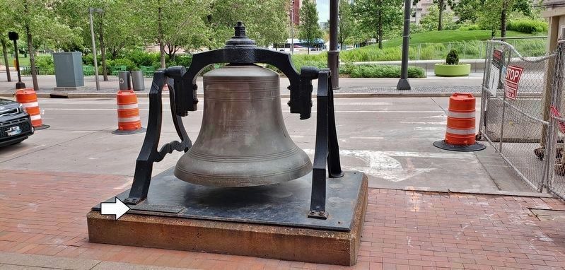
This bell was cast and raised to the belfry of Old Stone Church in the year 1865 and took part in the service of Thanksgiving celebrating the end of our Country’s Civil War. It tolled at the time President Abraham Lincoln’s cortege stopped at Public . . . — — Map (db m192300) HM
On West Mall Drive south of Lakeside Avenue East, on the left when traveling south.
The First Christmas Tree in America publicly lighted and displayed in a church Christmas service stood where the Cleveland Public Auditorium now stands, a designated Cleveland Landmark. On that site once stood the original Zion Lutheran Church . . . — — Map (db m182144) HM
On Ontario Street at Public Square (Rockwell Avenue), on the left when traveling south on Ontario Street.
The spire which rises above this tower stands as a tribute to those pioneers and early settlers of Cleveland, many of whom were members of this church, whose deep inner faith and resulting spiritual strength enabled them to lay the strong . . . — — Map (db m192273) HM
On Public Square at Ontario Street on Public Square.
Religious worship began on this site in 1820 as a Plan of the Union Sunday School with ministers recruited by the Connecticut Home Missionary Society. Its first stone church, officially known as the First Presbyterian Church of Cleveland, was built . . . — — Map (db m17864) HM
On Triskett Road, 0 miles east of West 144th Street, on the left when traveling east.
Here in 1963 congregants of Beth Israel-The West Temple, led by Louis Rosenblum, Herb Caron, and Rabbi Daniel Litt, founded the Cleveland Committee (later Council) on Soviet Anti-Semitism, the first American organization created to advocate for . . . — — Map (db m230146) HM
On Broadway Avenue (Ohio Route 43) at East 55th Street on Broadway Avenue.
North and South Broadway were originally part of Newburgh Township, organized in 1814 as one of the earliest settlements in Cuyahoga County. The contruction of the Ohio & Erie Canal and later railroads led to industrial and commercial growth, . . . — — Map (db m21073) HM
On Lorain AVenue (Ohio Route 10) at West 30th Street, on the left when traveling east on Lorain AVenue.
In 1886, Bishop Richard Gilmour (1824-1891) of the Roman Catholic
diocese of Cleveland requested that the Jesuit superior of Buffalo
establish a high school on Cleveland’s west side. The Jesuits, an
order of the Roman Catholic Church founded by . . . — — Map (db m229238) HM
Briton, industrialist and philanthropist who came to Cleveland in 1848. Formed the Cleveland Provision Company in 1875, Cleveland's largest meat packer. Pioneered meat shipping using refrigerated cars. Built the Rose Building, E. 9th and Prospect, . . . — — Map (db m12116) HM
On Turney Road at Granger Road, on the right when traveling north on Turney Road.
German Corners. The intersection of Turney and Granger Roads, called German Corners in the 1800s, later became known as South Newburgh Centre. At its earliest Turney Road was known as State Road and then Fisher Road. Finally, it was named for . . . — — Map (db m230486) HM
On Lorain Road (Ohio Route 10) at Columbia Road (Ohio Route 252), on the right when traveling west on Lorain Road. Reported missing.
In 1823, Asher and Abigail Coe migrated from Connecticut and settled here. By mid-century the Coe family operated the second largest dairy farm in Ohio. Their home was used as a post office in 1843. The Universalist Church, built in 1847 at . . . — — Map (db m202520) HM
On Porter Road north of Lorain Road (Ohio Route 10), on the left when traveling north.
The Universalist religious movement spread across Ohio as the state was settled in the 1800s. Universalists proclaimed a loving God and universal salvation. Believers were sometimes scorned as “no-Hell-ers.” Olmsted’s First Universalist . . . — — Map (db m134225) HM
On Mastick Road at Clague Road, on the right when traveling east on Mastick Road.
Side A: Joseph Peake was born in Pennsylvania in 1792 and came to Ohio in 1809 with his parents and brother. They were the first African Americans to settle permanently in the Cleveland area. He was the son of George Peake, a runaway slave from . . . — — Map (db m43348) HM
On Lander Road, 0.3 miles north of the circle at Fairmount and Gates Mills Boulevards, on the left when traveling north.
The first women’s college chartered in the state of Ohio, Ursuline College opened in 1871 in downtown Cleveland as part of the educational mission of the Order of St. Ursula (O.S.U.). Founded in Italy in 1535 with an early presence in North America, . . . — — Map (db m137093) HM
On Fontenay Road, 0.2 miles south of Shaker Boulevard (Ohio Route 87), in the median.
This site marks the location of the main dwelling of the East or Gathering Family established for the expressed purpose of gathering souls "out of the world". Here the new converts were "proved awhile" until they convinced the elders and eldresses . . . — — Map (db m10422) HM
On South Park Boulevard, 0.2 miles east of Lee Road, on the right when traveling east.
In 1822, Ralph Russell, a Connecticut pioneer who had settled in Warrensville Township ten years earlier, founded the North Union Shaker Community. The Shakers created Horseshoe Lake in 1852 when they built a dam across Doan Brook and harnessed its . . . — — Map (db m10423) HM
On Lee Road at Shaker Boulevard (Ohio Route 87), on the right when traveling south on Lee Road.
These two original gate posts mark the entrance to a field once used by the Middle Family of Shakers, who resided in this vicinity.
This tablet erected September 21, 1948, commemorating the 126th anniversary of the North Union Society of Shakers. . . . — — Map (db m17824) HM
Near Lee Road north of Chagrin Road (U.S. 422), on the right when traveling north.
This tablet marks the final resting place of the Shakers of the North Union Society. Their remains were moved from the Shaker burial ground on South Park Boulevard to this cemetery in 1909.
"Do all your work as though you had a thousand years to . . . — — Map (db m18034) HM
In 1845, the Disciples of Christ built the first of three churches to occupy this site. They built a second, larger structure, to replace the original in 1858. On August 6th, 1860. 29 year-old circuit minister Brother James A. Garfield, the future . . . — — Map (db m224961) HM
On Westwood Drive at Pearl Road (U.S. 42), on the right when traveling east on Westwood Drive.
The Pomeroy House, built from 1847 to 1848, was the home of Alanson Pomeroy and his wife, Kezia. They continued the tradition, known as "Pomeroy Hospitality," that began when Alanson's parents established a tavern in Strongsville. Prominent in the . . . — — Map (db m43386) HM
John Carroll University opened its doors as Saint Ignatius College on
September 6, 1888. Originally located on Cleveland’s West Side, the
College was founded at the request of Bishop Richard Gilmour by
German members of the Society of Jesus (the . . . — — Map (db m190030) HM
On Long Road (County Route 345) at Rehmert’s Run Road, on the right when traveling west on Long Road.
On this site in 1839, on 1 ½ aces, kindly donated by Nickolas Marchal, a
log church 32 ft. x 40 ft. x 18 ft. high was built by he and
his sons. It was to be called St. Valbert Parish.
It was the first Catholic Church in this area and . . . — — Map (db m120363) HM
Near Krouse Road (County Road 146) 0.2 miles north of U.S. 24, on the right when traveling south.
This church building was constructed in 1875 by the congregation. It was moved in 1902 to land purchased by the church for future development. A new church was constructed and dedicated in 1904. After moving into a new structure, this building . . . — — Map (db m182986) HM
On West High Street west of Main Street, on the left when traveling west.
St. Paul's Episcopal Church
1875
National Historical Site
Marked in 1990
Hicksville Historical Society &
Capt. George Athey Chpt., CDXVIIC — — Map (db m53221) HM
On County Route 424, on the right when traveling east.
In 1855, Pioneer Roman Catholic settlers
of the Black Swamp erected a 16 x 24
log church where you are now standing
reserving the land beside it for their
cemetery thus founding St. Stephen's
Parish.
Here they assembled to worship . . . — — Map (db m173133) HM
Samuel Patterson arrived in East Orange in 1824 and, within a few years, began to hide runaway slaves in his home. He also invited anti-slavery speakers to the pulpit of the East Orange Methodist Church, which brought Patterson and his neighbors . . . — — Map (db m20550) HM
Built in 1833 as a health resort named the Mansion House Hotel, Elliott Hall is noted as Ohio's oldest collegiate Greek Revival building. The closure of the Bank of the United States and an economic panic in 1837 created nation-wide financial . . . — — Map (db m12822) HM
On Olentangy River Road (Ohio Route 315) at Home Road, on the left when traveling north on Olentangy River Road.
Liberty Presbyterian Church
Founded in 1810
The first religious society organized in Liberty Township was formed in 1810 by Elders Thomas Cellar, Josiah McKinnie, and Leonard Monroe. Cellar and McKinnie came to Delaware in 1802. In 1820, The . . . — — Map (db m179476) HM
Near South Sandusky Street at Park Avenue, on the right when traveling north.
Ohio Wesleyan University was established in 1842, in one building (Elliot Hall) which at the time was located a short distance from the proposed location for the bioretention cell. Elliot was built near a sulphur spring, which flowed into the . . . — — Map (db m203316) HM
On West Winter Street west of North Franklin Street, on the left when traveling west.
On May 9, 1817, an Instrument of Parochial Association to form
St. Peter’s Episcopal Church was signed by eleven prominent
citizens of Delaware, Ohio. In 1824, Bishop Philander Chase of
the newly-formed Diocese of Ohio provided a wooden model . . . — — Map (db m228242) HM
Ohio Wesleyan owes its location to the initial efforts to establish a resort for healing purposes on the site of the Sulphur Spring. When the business faltered, Adam Poe, a pastor and several citizens purchased it and gave it to the Methodists for a . . . — — Map (db m18313) HM
Near South Sandusky Street at Spring Street, on the right when traveling north.
The labyrinth is an ancient circular pattern found in many cultures dating back over 5000 years. This design is a replica of the medieval 11-circuit labyrinth embedded in the floor of Chartres Cathedral in France. A single path winds to the . . . — — Map (db m203319) HM
On West Willam Street (Marysville Road) (U.S. 36) at North Franklin Street, on the right when traveling west on West Willam Street (Marysville Road).
William Street United Methodist Church.
The first Methodist class in Delaware was organized
in 1818, later to become William Street United
Methodist Church. The first church building was
dedicated in 1824 directly across N. Franklin . . . — — Map (db m169863) HM
On Washington Street at Bernard Avenue, on the right when traveling south on Washington Street.
Organized in 1845, Zion African Methodist Episcopal Church is the oldest congregation of African descent in Delaware, with Reverend Daniel Winslow serving as the first minister. In 1853 the cornerstone of the first church was laid, which was . . . — — Map (db m12823) HM
On Hyatts Road, 0.1 miles east of Steitz Road, on the right when traveling east.
In 1985, Hindu immigrants from India formed a celestial organization, The Bharatiya Temple Society of Central Ohio, and through its membership adopted the Constitution and Bylaws and named the place of worship Bharatiya Hindu Temple. Later they . . . — — Map (db m12819) HM
On Ohio Route 521, on the left when traveling east.
This bell hung in the Eden Methodist Episcopal Church from 1908 - 1968. The old church was located on Lot 40, near this site. The bell was in active use from its installation in 1908 until 1940 when its use was discontinued due to structural . . . — — Map (db m236801) HM
On South Old State Road (County Route 10) at Ashcreek Ave., on the right when traveling north on South Old State Road.
First Jain Temple in Central Ohio
“Souls render service to one another”
The Jain Center of Central Ohio was established on May 12, 1991. The foundation stone of the Jain temple, the first of its kind in Central Ohio, was laid down on . . . — — Map (db m105528) HM
On Meredith Road (County Route 191) at Lawrence Road (County Route 189), on the right when traveling north on Meredith Road.
Site of the
Radnor Presbyterian Log Church,
of the
Joint Delaware- Liberty- Radnor
Congregation
built 1819
Distinguished Sunday School Missionary
Benjamin W. Chidlaw
was a member of this church
1829- 1836
erected 1960 — — Map (db m89485) HM
On Radnor Road (County Road 198) at Baker Street, on the right when traveling east on Radnor Road.
The first religious society in Radnor Township was organized by Welsh Baptists on May 4, 1816. It consisted of 11 members who met in a log school where services were held in Welsh. In 1819, the first church, a hewed log meeting house, was built next . . . — — Map (db m237061) HM
On Ohio Route 203 south of Radnor Road (County Road 198), on the left when traveling north.
Originally called The The Welsh Calvinistic Congregational Bethel Church of Delhi, the name was shortened later to The Radnor Congregation Church and finally to its current name. Radnor Congregational United Church of Christ. The early church . . . — — Map (db m238287) HM
On Granville Street at Columbus Street, on the left when traveling east on Granville Street.
Side A:
Sunbury, Ohio
“An Ohio Stagecoach Town from 1820-1873”
From its beginning in 1816, Sunbury was destined to be a stagecoach town. Anticipating large numbers of stagecoach travelers in Sunbury, the town's founder, Lawrence . . . — — Map (db m18304) HM
On Africa Road, 0.2 miles south of Polaris Parkway, on the right when traveling north.
The Sharp family homes and their locations on N. State Street and Africa Road mark an important route through Westerville on the Underground Railroad. The family patriarch, Garrit Sharp, was an original settler of Sharp's Settlement, now . . . — — Map (db m171804) HM
On Park Street at Ohio Street, on the right when traveling east on Park Street.
The Episcopal Society of Huron was organized in 1837, the Rev. F. M. Levenworth, pastor. The cornerstone of this building was laid on May 23, 1838; it is the oldest church building in Huron, standing near what had been the original southern limit of . . . — — Map (db m141643) HM
On Division Street, 0.3 miles north of West Lakeshore Drive (Ohio Route 575), on the right when traveling north.
The German Reformed Church was organized on Kelleys Island in
1865. The congregation built this church from island stone in 1866
on ½ acre of land purchased from Alfred S. and Hannah Kelley. By
1871, the congregation, one of five on the island, . . . — — Map (db m241149) HM
On North Main Street, on the left when traveling south.
The last mission of the Moravians in the Valley of the Huron in the Ohio Country was at the Indian Village of Pettquottink, now Milan. — — Map (db m90658) HM
On Wayne St near Huron Ave., on the right when traveling north.
This building was begun in 1835 and was completed in 1844. It is the oldest church building in continual use in Sandusky and incorporates a portion of the original structure. This marker commemorated the one hundred fiftieth anniversary of the . . . — — Map (db m79103) HM
On Tiffin Avenue (U.S. 6) at Clinton Street, on the left when traveling south on Tiffin Avenue.
Holy Angels Catholic Church is the mother church of Sandusky.
Reverend Joseph P. Machebeuf, a French Missionary, began ministering
to Catholics in the Sandusky area in late 1839.
Soon after William
H. Mills offered five lots, $530, and the . . . — — Map (db m142162) HM
On Columbus Avenue south of East Jefferson Street, on the left when traveling south.
Legendary University of Notre Dame Head Football Coach
Knute Rockne married Bonnie Skiles of Kenton, Ohio in the
rectory of Saints Peter and Paul Catholic Church on July 15,
1914. Father William F. Murphy officiated.
The two met in the summer of . . . — — Map (db m141931) HM
On East Jefferson Street just east of Wayne Street, on the right when traveling east.
The Methodist Episcopal Church pioneered
organized religion in Perkins Township
1811, then in Sandusky when the Rev. Alfred
Brunson preached the city’s first sermon in
January, 1818. In 1829 the Methodists built
Sandusky’s first church, on West . . . — — Map (db m142005) HM
On Venice Road (U.S. 6) near Fremont Avenue (U.S. 6), on the left when traveling west.
[Marker Front]:
The first Venice flour mill was built on this site in 1822. Russell Heywood of Buffalo bought the mill in 1831 and rebuilt it in 1833. Fed by water from underground springs, the mill was in almost constant operation. . . . — — Map (db m20476) HM
On Walnut Street at Mulberry Street, on the left when traveling west on Walnut Street.
Stone from area of
Wesley Chapel • 1806
First edifice of the
Bremen United
Methodist Church
First trustees
Zebulon Holliday
George Blosser
Eli Gardner — — Map (db m27106) HM
On Elmwood Drive near West Fair Avenue, on the right when traveling north.
was placed on the
National Register of Historic Places
by the National Park Service,
U.S. Dept. of the Interior,
Sept. 10, 1987 in recognition of its
historical and architectural significance.
Originated at Logan 1872;
moved to . . . — — Map (db m52871) HM
On Maple Street north of Main Street (U.S. 22), on the left when traveling north.
This Cornerstone
is from the
original Maple Street
United Evangelical Chapel
which stood at the northeast corner of the alley
on Maple Street between Main and Wheeling Streets
——— • . . . — — Map (db m137730) HM
On East Wheeling Street at North High Street, on the right when traveling west on East Wheeling Street.
...commissioned in 1849 to ring the praise of Almighty God from the steeple of the old M.E. Church on South Jackson (High) Street, this bell was relocated by the congregation to their present church in September 1907. Eventually displaced by . . . — — Map (db m97373) HM
On Cincinnati-Zanesville Road (U.S. 22) at Sixteenth Road, on the right when traveling east on Cincinnati-Zanesville Road.
The Israel Evangelical Lutheran Church was organized August 23, 1812. According to available records, in 1813 the first meeting in Ohio of the “Special Conferences” called by the Lutheran Ministerium of Pennsylvania was held at the . . . — — Map (db m13353) HM
On Main Street (Ohio Route 41) at Cross Street, on the right when traveling east on Main Street.
Side A
Recognized by many as “one of the most active communities in Southwestern Ohio, the Bloomingburg area was a significant link in the Underground Railroad. As many as twelve to sixteen escaped slaves were said to have been passed . . . — — Map (db m121781) HM
On Main Street (Ohio Route 238) at the cemetery entrance, on the left when traveling north on Main Street.
The Bloomingburg Presbyterian Church and cemetery was established in the northwest corner of the current cemetery grounds on March 7, 1818. Several years later it became a center for anti-slavery activity. The Reverend William Dickey, who presided . . . — — Map (db m27821) HM
Irish railroad workers founded the Catholic community in Washington Court House in the 1850s, with the first Mass being held in a local shanty in 1852. In 1871, Father John B. O'Donoghue purchased three and 5/8 acres of land adjoining Washington . . . — — Map (db m27834) HM
The Judy Memorial Chapel
built 1905
has been placed on the
National Register
of Historic Places
by the United States
Department of the Interior — — Map (db m27964) HM
On East Broad Street (Ohio Route 16) at South Stanwood Road, on the right when traveling east on East Broad Street.
The spirit is not dead
Proclaim the word,
Where lay dead bones,
A host of armed
Men stand!
Hope your graves,
My people,
Saith the Lord,
And I shall place you
Living in your land.
Emma . . . — — Map (db m201228) HM WM
On Pleasant Ridge Avenue at Main Street (U.S. 40), on the left when traveling north on Pleasant Ridge Avenue.
Founded in 1830 as a Lutheran Seminary and chartered as a University in 1850, Capital University offers diverse undergraduate and graduate programs in the arts, sciences and professional studies.
Ethical, moral and religious values essential to . . . — — Map (db m15784) HM
On John McConnell Boulevard at Spring Street (U.S. 33), on the right when traveling north on John McConnell Boulevard.
[Marker Front]:
Thousands of Irish immigrants came to Columbus to seek personal and religious freedom. With the "Great Hunger" in Ireland and the completion of the Ohio and Erie Canal and the National Road, immigration to Columbus increased . . . — — Map (db m12963) HM
On High Street (U.S. 23) at Stimmel Street, on the right when traveling south on High Street.
The German Seminary of the Evangelical Lutheran Synod of Ohio, the first Lutheran theological seminary west of the Appalachian Mountains, began instruction under Pastor Wilhelm Schmidt in Canton in 1830. The seminary relocated to Columbus at this . . . — — Map (db m80014) HM
On High Street (U.S. 23) at the Pontifical College Josephinum entrance road, on the right when traveling south on High Street.
Monsignor John Joseph Jessing, founder of the Pontifical College Josephinum, was born in Germany in 1836. He immigrated to America and, in 1870, was ordained a priest in Columbus. He published a newspaper, the Ohio Waisenfreund (Ohio Orphans' . . . — — Map (db m12870) HM
On Grant Street at Naghten Street, on the right when traveling north on Grant Street.
Side A:St. Patrick Church
Built in 1852 and dedicated a year later, St. Patrick Church is the second oldest Roman Catholic Church in Columbus. Founded as the English speaking parish, this church of Norman Gothic design served as the home . . . — — Map (db m17474) HM
On East Broad Street (U.S. 40/62) at Cleveland Avenue (Ohio Route 3), on the right when traveling west on East Broad Street.
As an early advocate of social justice, the Rev. Dr. Washington Gladden led local and national causes for civil rights, workers' rights, voting rights, religious pluralism, school integration, and the needs of the poor and the oppressed.
The . . . — — Map (db m201044) HM
On East Broad Street (U.S. 40) at South Washington Street, on the right when traveling east on East Broad Street.
This site was
formerly occupied by the
Wesley Chapel
Methodist Church
and its successor
Central
Methodist Church
merged with
Broad Street Methodist Church
October 1935 — — Map (db m98928) HM
On Long Street at Jefferson Avenue, on the right when traveling east on Long Street.
The King Lincoln District was established in July 2002 to honor the historic heart and soul of Columbus’ African American community. This arch, welcoming all to the King Lincoln District, is dedicated to our shared history and our commitment to the . . . — — Map (db m16965) HM
On East Broad Street (U.S. 40) at North Fifth Street, on the right when traveling west on East Broad Street.
St. Joseph Cathedral
November 11, 1866, the cornerstone
of St. Joseph Cathedral was laid at the
N.W. corner of E. Broad and 5th Sts. The
beautiful gothic structure was
completed n 1872. The consecration
service took place October 20, 1878,
a . . . — — Map (db m98924) HM
On Long Street at Jefferson Avenue, on the right when traveling east on Long Street.
Organized in 1823 as Bethel African Methodist Episcopal Church, St. Paul A.M.E. Church is the oldest congregation of African descent in Columbus. The church, founded by Moses Freeman and 13 other members from the Town Street Church, was originally . . . — — Map (db m16963) HM
Near North Davis Avenue at River Street, on the right when traveling north.
(side A)
In this churchyard stood the first church of the community, The First Presbyterian Church, built and presented to the congregation in 1811 by Lucas Sullivant.
Here in this plot of ground, which he gave to the pioneers, he . . . — — Map (db m88307) HM
Dedicated July 4, 1992 by the Citizens of Columbus
Maynard E. Sensenbrenner served four terms as mayor of the City of Columbus, 1954-1959 and 1964-1971, longer than any other mayor. During this time he was responsible for the farsighted . . . — — Map (db m16960) HM
On Hamlet Street at Cedar Alley, on the left when traveling south on Hamlet Street.
The Italian Community gratefully remembers
Father Rocco Petrarca
Pastor of
St. John the Baptist Church
from 1913 to 1948
“Flos Memoriae Lapide Perennior” — — Map (db m14489) HM
On Hamlet Street at Lincoln Street, on the left when traveling south on Hamlet Street.
Reverend Father Alexander Cestelli. The National Italian Catholic parish of Saint John the Baptist was founded in October 1896 by the Reverend Father Alexander Cestelli, D.D. Father Cestelli was born in Fiesole, Italy and came to America in . . . — — Map (db m14487) HM
Second Baptist Church - Columbus' Oldest Black Baptist Church, 1836. Second Baptist Church cordially received its independence as a mission church from the First Baptist Church on January 7, 1836. Rev. Ezekiel Fields was chosen as pastor . . . — — Map (db m17174) HM
On Mount Vernon Avenue at Hamilton Avenue, on the left when traveling east on Mount Vernon Avenue.
The Shiloh Baptist Church was completed in 1923. Founded in 1869, Shiloh is the third oldest African-American church in Columbus and is a descendent of the Second Baptist Church. The church is located in the Mt. Vernon neighborhood, which is . . . — — Map (db m17472) HM
On Mohawk Street south of East Sycamore Street, on the right when traveling south.
For over a century, this site was part of St. Mary Catholic Church, established to serve the many German families moving into the area in the 1860s.
A primary mission of St. Mary's parish has been the education of its children. The first . . . — — Map (db m141818) HM
On South 3rd Street just south of East Sycamore Street, on the left when traveling south.
St. Mary Church was dedicated in 1868 in response to the spiritual needs of the growing German-Catholic population of Columbus’ South Side. The original schoolhouse, which stands behind the church, was erected in 1865 under the direction of Rev. . . . — — Map (db m20522) HM
Side A: Saint Mary of the Springs Academy On this site stood St. Mary of the Springs Academy, a school for girls first founded by the Dominican Sisters in 1830 in Somerset, Ohio, to respond to the educational needs of frontier Catholics. The . . . — — Map (db m17387) HM
On Sunbury Road, on the left when traveling south.
Ohio Dominican University Est. 1911 The Dominican Sisters of St. Mary of the Springs founded Ohio Dominican University on this site on October 5, 1911. It was incorporated that year as the Ladies Literary Institute of St. Mary of the Springs, . . . — — Map (db m94624) HM
On Sunbury Road, on the right when traveling north.
Honoring the history of
Saint Mary of the Springs Academy
founded 1830
flourished on this site
1868- 1966
Dedicated to the alumnae
and the Dominican Sisters
in celebration of
the spirit that they have
carried into the world — — Map (db m94625) HM
Side A
In 1968, the International Society for Krishna Consciousness (ISKCON) established the first practicing Vedic Temple in the state of Ohio. This building represents the beginning of a now growing population of Vaisnavas, worshipers of . . . — — Map (db m225381) HM
On Old National Road (U.S. 40) at South Third Street (U.S. 62), on the right when traveling east on Old National Road.
First services of Trinity Episcopal
Church were held May 3, 1817, in the
residence of Dr. Lincoln Goodale,
where later Columbus’ first Sunday
School was founded.
The first church building was built
in 1831 one half block east of High
on . . . — — Map (db m98848) HM
On High Street at Clark Street, on the right when traveling south on High Street.
Built on Granville Street in Mid 1800's as manse for Presbyterian Church. Most furnishings are original from Clark family (a founder of Gahanna). — — Map (db m14450) HM
On Stringtown Road at Buckeye Parkway, on the right when traveling east on Stringtown Road.
There are two, five-acre farm tracts lying East of this plaque. In 1929 Fred and Georgie Wray acquired one tract and in 1937 the other tract was purchased by their son, Stanley O. Wray Sr. (The original deed dated back to the Virginia Militia) . . . — — Map (db m176240) HM
On Broadway (U.S. 62) south of Grant Avenue, on the right when traveling south.
Built by W.C. Grossman as
the Kingdom Theater for
Mrs. Jessie Köenig.
OLPH owned and celebrated
Mass in the building from
1954 to 1959.
LTOB Players purchased
the building in 1976. — — Map (db m137682) HM
626 entries matched your criteria. Entries 101 through 200 are listed above. ⊲ Previous 100 — Next 100 ⊳