On Winchester Road, 0.2 miles west of North 13th Street (U.S. 27), on the left when traveling west.
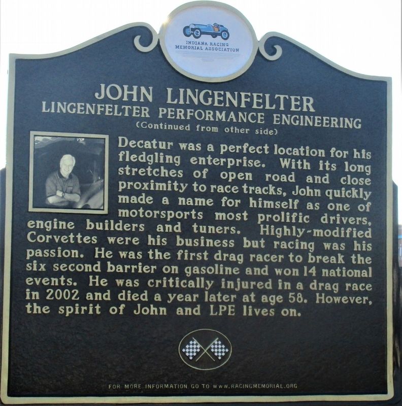
Maybe it was foretold that Pennsylvanian born John Lingenfelter would become one of racing's most legendary engine builders. The gifted son of a mechanic, John began working on cars almost as soon as he could hold a wrench. A move to Indiana to . . . — — Map (db m168283) HM
On North 400 East, 0.1 miles East North (U.S. 224), on the left when traveling north.
General Anthony Wayne and the Legion of the United States passed this way on October 30, 1794, in route from Fort Wayne to Fort Greenville, ending the western campaign against the Indian Confederacy. The Legion spent the previous night camped 2.6 . . . — — Map (db m29620) HM
Near Coldwater Road at E. Ludwig Road, on the right when traveling south. Reported missing.
The Rural Branch School of the Church was located adjacent to the cemetery. School was conducted from 1844 to 1920. The building and grounds were sold to the State for the interchange of Highways I 69 and U.S. 27. — — Map (db m76433) HM
On E. Main Street, on the left when traveling east.
This Barr and Columbia Street intersection is the center from which Civic Fort Wayne Grew
North West
Barnett-Hanna Trading Post 1819
First Post Office 1820
North East
Suttenfield Tavern 1823
South West . . . — — Map (db m197325) HM
On Coliseum Blvd (Indiana Route 930) east of Parnell Avenue, on the right when traveling east.
One of auto racing’s premier sanctioning bodies, the United States Auto Club (USAC). Held it’s very first race here in Fort Wayne, at the historic Allen County Memorial Coliseum. USAC was formed urgently on September 16, 1955, when racing . . . — — Map (db m207690) HM WM
On North Wells Street, on the right when traveling north.
An ancient Indian trail, through Pottawattomie country, variably called the Dragoon, White Pigeon, Great Northwestern and Fort Dearborn Road. After 1795 used for mail delivery between Fort Wayne and Fort Dearborn. Captain Wells, Wayne spy, was slain . . . — — Map (db m20782) HM
On Indiana Route 37 at Antwerp Road, on the right when traveling east on State Route 37.
On north bank of prehistoric Lake Maumee. The ridge formed by the bank was part of the pioneer overland trace from Detroit to Fort Wayne. This route was surveyed as early as 1837 for the ridge road, served in the late nineteenth century as a toll . . . — — Map (db m183602) HM
On Hoagland Road just east of Poplar Drive, on the right when traveling east.
Once an Indian trail directly through these school grounds, the route followed by General Anthony Wayne's army in its departure from the fort in 1794 and the way by which General William Harrison's troops came to the relief of the garrison at Fort . . . — — Map (db m211614) HM
On U.S. 24 at Harper Road, on the right when traveling east on U.S. 24.
Wabash and Erie Canal lock was discovered here June 1991 during excavation for highway construction. It was built 1838–1840 by Henry Lotz and named for lock keeper Joseph Gronauer. The rare, well-preserved timber-frame design lock measured . . . — — Map (db m2498) HM
On Lincoln Highway East west of Broadway Street, on the right when traveling west.
The Lincoln Highway was the first auto road across the United States. Promoted by Carl G. Fisher, of Indianapolis, the Lincoln Highway route was announced in 1913. From Times Square in New York City to Lincoln Park in San Francisco, the Lincoln . . . — — Map (db m197131) HM
On Michigan Road (U.S. 421) at Valley Meadow Drive, on the left when traveling north on Michigan Road.
With proceeds from the sale of 170,580 acres of Indian land granted by the Federal Government, Indiana built its first north-south road. Surveyed 1829, passable by 1834, "completed" in 1837, its cost was $242,000.00. — — Map (db m67191) HM
On Michigan Street (a.k.a.: St Rd 29) at East 7th Street, on the right when traveling north on Michigan Street (a.k.a.: St Rd 29).
Laid out in 1828 by David Stipp. Promoted for seat of a new county to be made partly from the Great Miami Reserve, which began two mile east. The Lafayette & Muncie Road crossed the Great Michigan Road here. It was an important stage stop, mill . . . — — Map (db m42709) HM
On County Road N 700 W north of County Road W 675 N, on the right when traveling north.
90 lots platted in 1836 on both sides of Wabash - Erie Canal lock.
A Post office in 1838 - 39. The lock passed canal boats into the river on the pool of the Great Dam at Pittsburg five miles below. The mules carried the towline across the . . . — — Map (db m35413) HM
On Road N 700 W north of Road W 675 N, on the right when traveling north.
Carrollton on the Wabash
The Mentzer Tavern was built in 1840 at the north end of the Carrollton Towing Path Bridge that crossed the Wabash River. Erected by Ignatius Mentzer and George Friday, it opened as a cooper shop where barrels were made . . . — — Map (db m35438) HM
On County Road N 700 W north of County Road W 675 N, on the right when traveling north.
Front
The Wabash & Erie Canal meets the Wabash River
Carroll County Wabash & Erie Canal
Delphi, Indiana
See Photo #2:
1844 Timber Truss Bridge
The Wabash and Erie Canal authorities built the first bridge here in . . . — — Map (db m35445) HM
On Road N 700 W north of Road W 675 N, on the left when traveling north.
Front
The Longest Canal in North America
Carroll County Wabash & Erie Canal
Delphi, Indiana
The Wabash & Erie Canal extended 468 miles
from Toledo, Ohio to Evansville, Indiana
On March 2, 1827, a Congressional land grant made . . . — — Map (db m35449) HM
On Indiana Route 29 near County Road 400, on the right when traveling south.
The sycamores here line the sides of the Michigan Road, which connected the Ohio River with Lake Michigan and further opened Indiana for white settlement and trade. Under intense military and economic pressure, Potawatomi leaders ceded the land for . . . — — Map (db m201388) HM
On State Road 29 north of County Road E400N, on the left when traveling north. Reported permanently removed.
This row of sycamores sprouted from freshly cut logs used in the 1830's to corduroy a swampy section of the historic Michigan Road, the first state road in Indiana, running from Madison to Michigan City. — — Map (db m201386) HM
On East National Avenue (U.S. 40) west of Forest Avenue (Indiana Route 59), on the left when traveling east.
Brazil, just like her sister US 40 communities, prospered due to its location on the National Road. With the 1926 designation of the National Road as US 40, Brazil instantly became linked with the rest of the nation. Almost every raw material, . . . — — Map (db m233271) HM
On Park Street (County Route 1250N) at Local Route 900E, on the right when traveling east on Park Street.
Born in Odon, on July 17, 1889, Joseph Crook Dawson was one of the most acclaimed “Daredevils of The Speedways”, during the formative years of auto racing in this country. His most memorable accomplishment came in 1912, when he gained . . . — — Map (db m176080) HM
On NW 1st Street at West Maple Street, on the left when traveling south on NW 1st Street.
Residence of Robert C. Graham (1885-1967), pioneer glass, truck and auto manufacturer. Placed on the National Register of Historic Places in 1983 by the U.S. Department of the Interior because of its history and Prairie Style architecture. — — Map (db m23208) HM
On County Road S 300W, 0.1 miles north of U.S. 50, on the right when traveling north.
Robert Cabel Graham (1885-1967), a native of Washington, Daviess County, with his brothers Joseph and Ray, contributed much to the economy and quality of life in that city, Evansville, and other towns. Glass factories, truck manufacturing, and . . . — — Map (db m98936) HM
On Indiana Route 48, 0.2 miles west of Louden Road, on the left when traveling west.
The large brick house nearby was Baker's Drovers Inn. This highway was the early state Manchester & Lawrenceburg Turnpike. A short distance from here was a Toll-Gate house. — — Map (db m143035) HM
On Walnut Street north of East Center Street, on the right when traveling north.
L. Kohlerman, a local undertaker built
this example of Italianate architecture
c. 1875. In the 1860's and 1870's,
the streets in Lawrenceburg were
raised because of flooding from the
Ohio River. The first floors of
buildings were covered and . . . — — Map (db m222708) HM
On East Washington Street near North Broadway Street, on the right when traveling east.
Fisher, an entrepreneur who helped
make automobiles a viable form of
transportation, was born in Greensburg,
1874. He co-founded Prest-O-Lite Co.,
1904, which developed acetylene gas
vehicle headlights distributed
nationwide. Co-founder and . . . — — Map (db m207242) HM
Built by the Pan-American Bridge Company of New Castle, Indiana, in 1915. This bridge originally carried County Road 700 South over Sand Creek, 2.5 miles East of Letts, Indiana. This bridge was disassembled, rehabilitated, and reconstructed at . . . — — Map (db m22028) HM
On Gordon M. Buehrig Place just east of South Wayne Street, on the left when traveling east.
The Eckhart Carriage Company was established in 1874
in Auburn, Indiana. It was the direct ancestor of the Auburn Automobile Company as both were owned by the Eckhart family in the early days.
This is the last remaining building of the . . . — — Map (db m73297) HM
On Wayne Street at Gordon M Buehring Place, on the right when traveling north on Wayne Street.
Alan Leamy's everlasting gift to the automotive world is a legacy of
stunningly boautiful body styles that are the epitome of classic car design.
He was only 25 years old when he created the distinctive classic look
of the Cord L-29, America's . . . — — Map (db m185853) HM
On Wayne Street just north of Gordon M Buehring Place, on the left when traveling north.
Auburn. The Grand Trinity of classic automobiles—Auburn, Cord and Duesenberg—each played prominent roles in racing history. Established in 1900 by the Eckhart family, early models successfully competed in the popular speed and
reliability . . . — — Map (db m185849) HM
On Wayne Street at Gordon M. Buehrig Place, on the left when traveling south on Wayne Street.
Auburn Automobile Company (1900-1937) Art Deco Style Administration building, built 1929-1930. Housed departments of Cord Corporation, manufacturer of Auburn, Cord, and Duesenberg automobiles. Became Auburn-Cord-Duesenberg Museum, 1974; listed in . . . — — Map (db m53934) HM
On Wayne Street at Gordon M Buehring Place, on the right when traveling north on Wayne Street.
Auburn Cord Duesenberg Automobile Facility
has been designated a
National Historic Landmark
This industrial complex is a rare surviving example of an independent
specialty automobile company that manufactured . . . — — Map (db m185856) HM
On Wayne Street at Gordon M Buehring Place, on the left when traveling north on Wayne Street.
Augie was a tireless practical engineer who could turn mechanical
concepts into reality. The Duesenberg racecars upon which he labored
in the 1920s and 30s set top-speed and durability records, won the
French Grand Prix at Le Mans and were . . . — — Map (db m185846) HM
On South Van Buren Street at Walnut Street, on the left when traveling south on South Van Buren Street.
The name Duesenberg is forever linked with early motorsports. In 1913, German immigrant brothers Fred and Augie Duesenberg founded the company that bore their name in St. Paul, Minn., to produce the best high-performance custom engines and . . . — — Map (db m185841) HM
On Wayne Street at Gordon M Buehring Place, on the right when traveling north on Wayne Street.
In 1924, E. L. Cord was tochuited to manage the struggling
Auburn Automobile Company with the provision that he could secure
controlling interest if he were successful. He quickly assembled young.
talented engineers and designers that . . . — — Map (db m185855) HM
On Wayne Street at Gordon M Buehring Place, on the left when traveling north on Wayne Street.
Frank Eckhart was the oldest son of Charles Eckhart, founder of the
Eckhart Carriage Company. In 1902, Frank was inspired to build a
horseless carriage after being frustrated in his attempt to purchase one.
The result was the first Auburn . . . — — Map (db m185848) HM
On Wayne Street at Gordon M Buehring Place, on the left when traveling north on Wayne Street.
Inventor, engineer, and automotive pioneer Fred Duesenberg was responsible
for many technological innovations in the early twentieth century. As a
German immigrant, he shaped the automotive industry on both the race
track and public roads, . . . — — Map (db m185847) HM
On South Van Buren Street just north of Walnut Street, on the right when traveling north.
Gordon Buehrig was only 25 when he became the chief body designer
for Duesenberg, huilders of the most prestigious motor car in the
United StatCs. There he rendered some of the most stunning classic car
body designs ever penned. With his . . . — — Map (db m185850) HM
On Wayne Street at Lincoln Street, on the right when traveling north on Wayne Street.
From 1927 through 1936, Herb Snow was responsible for many of the
engineering advancements of the Auburn Automobile Company He was
intensely involved in both the Cord L-29 and 810//812 front-wheel-drive
projects. Snow is credited with the . . . — — Map (db m185857) HM
On South Van Buren Street at Walnut Street, on the left when traveling south on South Van Buren Street.
"No salesman can 'talk' quality into a car that has not been built into it,"
said E. L. Cord. Thus, the men empioyed by the Auburn Automobile Company
and Duesenberg inc., were charged with the demanding task of meeting
Cord's high expectations . . . — — Map (db m185843) HM
On Gordon M Buehrig Place just east of Wayne Street, on the left when traveling east.
Before the advent of the interstate highway system and modern hotel chains, travelers often had to sleep along the side of the road in their cars. Beginning just prior to 1920, travel courts and tourist camps began to appear and offered a warm, . . . — — Map (db m185860) HM
On Wayne Street north of Gordon M Buehring Place, on the left when traveling north.
Robert Wiley started his career at the Auburn Automobile Company in 1920
as a salesman. Prior to that, he served in the Philippines as a lieutenant
in the army. Upon his discharge, he obtained a job in the Auburn sales
department. When the . . . — — Map (db m185840) HM
On South Van Buren Street south of Walnut Street, on the left when traveling south.
The story of women workers at the Auburn Automobile Company is a
narrative of social change in Auburn and DeKalb County. Employment
at the auto company permitted women to become co-breadwinners in
their families during lean times. Although . . . — — Map (db m185844) HM
On River Greenway, 0.2 miles south of County Road 60, on the left when traveling east.
James Franklin Sechler (Frank), born in 1924, served his community in many exceptional ways until his untimely passing in 2007. Frank could have gone anywhere and been successful; however, he chose to dedicate his life to this community where he . . . — — Map (db m186254) HM
On River Greenway, 0.3 miles south of County Route 60, on the left when traveling south.
The 2018-19 Fourth grade class of Riverdale Elementary
commissioned this wooden statue of Jeff Gordon, dedicated
July 2019. The project was graciously funded by the Dekko
Foundation and was crafted by our local artist, David Drake.
The . . . — — Map (db m186268) HM
On Indiana Route 28 at County Route 875, on the right when traveling west on State Route 28.
On June 12, 2021, this location was dedicated to Don
Talley, Citizen Driver. Don is a decorated veteran who
served in the U.S. Army from 1974 to 1994 and began his
trucking career while serving in Saudi Arabia.
Don is a natural born leader, . . . — — Map (db m180759) HM
On East Elm Street (County Road 850N) at South Sycamore Street (County Road N600W), on the right when traveling east on East Elm Street.
The Barlett, Bryant, Vannata, and Veach families were the first settlers in 1837-1839.
In 1840-1850 the McCreery, Woodring and Maynard, Rowlett and Thompson families became property owners.
Snagtown ~ New Corner was platted by David L. . . . — — Map (db m141475) HM
Near Cardinal Greenway Trail at Wheeling Avenue, on the right when traveling south.
Several principal Indian and Pioneer Paths cut across Indiana and Delaware County
connecting trading and warrior routes of ancient times. First made by migrating large animals searching for salt, followed by Native Americans for food, trade and . . . — — Map (db m141410) HM
Near East Jackson Boulevard east of Marine Avenue, on the right when traveling east.
The old Indian trail which followed the Elkhart River, turned here to the northwest, and connected the “Miamis Fort” with “Fort St. Joseph”.
From the time of the French and Indian War in 1755 to 1763, up to the settlement of this section in . . . — — Map (db m200295) HM
On E. Beardsley Avenue east of Montessori Drive, on the right when traveling east.
Pulaski post office established here 1829. Fort Wayne Road, to Chicago-Detroit Road and Niles, forded the river at this point. Village of Elkhart was laid out in 1832 and post office name changed to Elkhart in 1839. — — Map (db m69729) HM
On East 5th Street at North Eastern Avenue (Indiana Route 1), on the right when traveling east on East 5th Street.
1669 ~ Early "Indian Trail" Connecting Cincinnati to Northern Trading Posts
1812 ~ First Blockhouse
1813 ~ First Public Square
1828 ~ Parker, then Fayette County Seminary
1858 ~ First Public School
1874 ~ First High School Added
1904 ~ . . . — — Map (db m152029) HM
On State Street, 0.2 miles south of West Daisy Lane, on the right when traveling south.
American Bison, migrating in great herds, created a cluster of paths along the natural topography between Illinois prairies and salt licks in Kentucky. These paths, called the Buffalo Trace, used by Native Americans and became premier travel route . . . — — Map (db m71282) HM
On East Market Street at State Street, on the right when traveling east on East Market Street.
In 1813 John Graham surveyed and platted a town which the Scribner brothers, founders of the town, named New Albany after Albany, New York. Within five years, the new community became the seat of the newly formed Floyd County. Boat building and . . . — — Map (db m194200) HM
On U.S. 41 at State Road 32, on the right when traveling south on U.S. 41.
John Gilmore entered first land in Township — 1826.
Alanson Savage built steam saw mill produced timbers for “Plank Road” — 1840.
Rev. Jones organized Methodist Church — 1852.
Early Families: Furrs, Booes, . . . — — Map (db m3805) HM
On U.S. 136 at South Layton Station Road, on the left when traveling west on U.S. 136.
Peter and James Layton, half brothers, came from New York, 1853. Here was the train stop for the residents of the area of the Plank Road ½ mile south. There a blacksmith shop, grocery, the stage stop, “Halfway House” were located. — — Map (db m3466) HM
On 1st Street at South Mill Street, on the left when traveling west on 1st Street.
One of the most iconic brand names in the world of sports has its origins here in the town of Veedersburg. The famed Indianapolis Motor Speedway is known the world over as “The Brickyard”, because the track surface was once composed entirely of . . . — — Map (db m175835) HM
On Toner Street (State Road 121) at Main Street, on the left when traveling north on Toner Street.
Here Edward Toner founded SOMERSET, 1816, & operated Toner's Tavern, 1816-1823, from which rallying point pioneers started west on Jacob Whetzel's Trace to the "New Purchase" of Central Indiana. — — Map (db m66859) HM
On Duck Creek Crossing, on the left when traveling west.
Erected in 1870's on lot #10, Eads Plat in Brookville, Ind., This Building housed Horses,
Carriages and Feed until the Automobile, then used as a garage. In the Spring of 1977 it was dismantled by removing handwhittled pins which held the frame . . . — — Map (db m159967) HM
On North Old US Highway 31 north of County Road E 350 N, on the right when traveling north.
Extending from Michigan City to the Ohio River at Madison. Begun by the state in 1832 with funds obtained from sale of land granted by the Potawatomi Indians. Opened northern part of state to settlers. — — Map (db m35346) HM
On U.S. 31 south of County Road W 375 N, on the right when traveling south.
Built in 1834 by William Polke, first white settler in Fulton County, this is the oldest and first frame house in the county and the first frame house built north of Wabash River. It was called the White House and was a stagecoach inn on the . . . — — Map (db m35327) HM
On Old U.S. 31 north of County Road 350N, on the right when traveling north.
William Polke was Fulton County's first white settler, coming
in 1830 to survey the Michigan Road. In 1831 he built a log
cabin trading post on south bank of the Tippecanoe River. He was post master of county's first post office called Chippeway, . . . — — Map (db m231180) HM
On West Broadway Street (Indiana Route 65) at North West Street, on the left when traveling east on West Broadway Street.
Gibson County was formed in 1813 from the southwestern portion of the Indiana Territory. Once the wheels of county government began turning, the push to locate a county seat was imminent. The settlement of Patoka had been selected for the seat, but . . . — — Map (db m190591) HM
On 4th Street south of High Street, on the right when traveling east.
Built at New Cumberland in 1877 by William Parks of Marion at a cost of $722. The 1913 flood floated the bridge a half mile downstream. It was returned to its foundations by rollers and horsepower. New Cumberland was the second community in Grant . . . — — Map (db m7479) HM
On South Main Street (Indiana Route 22) south of Railroad Street, on the left when traveling north.
Main Street was a very popular place for the towers residents especially on Saturday night. Every Saturday night, Upland area residents had a Farmers' Market all along Main Street to sell their wares Homemade jellies, tanned leather items, farm . . . — — Map (db m215115) HM
On Forest Park Driveway, 0.2 miles west of Cicero Road, on the left when traveling west.
Known internationally as one of America’s most popular and successful short-track racers, Bryan Clauson was also a proud Noblesville Miller. Despite his passing in 2016, at only age 27, his mark was already indelible. 112 USAC wins ranks him in . . . — — Map (db m175607) HM
On Conner Street (State Road 32/38), on the left when traveling east.
The long-standing carriage & wagon manufactory of Heylmann & Sons had its beginnings here. Built in 1872, it is one of downtown's oldest remaining structures. A facade remodeling in 1918 updated it for a new tenant, the gas company. — — Map (db m27888) HM
On Maple Avenue west of South 9th Street, on the right when traveling west.
A crowd of fascinated residents gathered to witness the construction of the first brick street in the town of Noblesville — then an exciting modern innovation. Although this photo of the square being paved is dated 1892, there is no evidence that . . . — — Map (db m232635) HM
On Allisonville Road, on the right when traveling west.
First bridge spanning White River at Potter's Ford was commissioned 1860 and named after the landowner, William Potter. In 1870, Hamilton County Commissioners voted for construction of this "Howe Truss" bridge. It was finished 1871 and . . . — — Map (db m8165) HM
On 9th Street at Maple Avenue, on the left when traveling south on 9th Street.
In 1915 George C. Richwine built a combination apartment house and business block on the site of his home and buggy shop. Then considered a monstrosity, this unusual California mission style glazed brick building is revered today. — — Map (db m27889) HM
On South State Street (U.S. 40) at South State Street (Indiana Route 9), on the left when traveling west on South State Street.
Information always travels by the best available technology. In the 19th century, the National Road (Main Street) along which you now stand, represented the latest in state-of-the-art communications.
Today many of us rely on sophisticated . . . — — Map (db m130948) HM
On North Green Street (Indiana Route 267) at Interstate 74, on the right when traveling south on North Green Street.
Larry Rice lived a life full of accomplishment, reaching the pinnacle of success in the sport he was passionate about, auto racing. A two-time starter in the Indianapolis 500, he won Co-Rookie Of The Year honors in 1978. He was twice the USAC . . . — — Map (db m174976) HM
On Foxwood Drive just west of South Locust Lane, on the left when traveling west.
Born here in Brownsburg. Robbie Stanley wanted nothing more than to drive race cars, and drive them well. In his brief life, he far exceeded those expectations. At only 6, he was 69 racing quarter midgets. He was spectacular, winning over 200 . . . — — Map (db m233076) HM
On West Main Street (U.S. 40) west of West Street, on the right when traveling east.
A waitress named Marge. A red vinyl stool at the counter. The pie case and the bottomless cup of coffee. Diners were America's first fast-food restaurants.
As automobile traffic increased on the National Road in the 1920s, diners sprang up to . . . — — Map (db m233274) HM
On East Main Street (U.S. 40) at North Washington Street, on the right when traveling west on East Main Street.
Constructing the National Road through Indiana in the early 19th century was a monumental task. The road, which crossed the rich soil of Indiana, connected people, wealth, and commerce and linked the state to the rest of the nation.
Increased . . . — — Map (db m233244) HM
Near East Main Street south of South Howard Street.
Placed on the National Register of Historic Places September 1, 1983, by the United States Department of the Interior in cooperation with the Indiana Department of Natural Resources Division of Historic Preservation. — — Map (db m233438)
Near East Vaile Street at South Market Street, on the right when traveling west.
The Apperson Farm, where the Apperson brothers grew up, was just one mile west of Center. Elmer was the older brother and he served his apprenticeship in Kokomo at the Star Machine Works. Then he opened the Riverside Machine Works close to . . . — — Map (db m200596) HM
Delco Radio Plant
Employees leaving the Delco Radio Plant in 1940, located on Home Avenue. Delco Radio Division began manufacturing operations in Kokomo in this plant formerly owned by Crosley Manufacturing Company and produced the first . . . — — Map (db m214910) HM
Elwood Haynes rode the crest of industrialization brought on by the gas boom, led the county's recovery when gas ran out and left a legacy of innovation for the entire world. He led the chemistry department at Eastern Normal School (now Ball State . . . — — Map (db m230886) HM
On South Webster Street south of West Ricketts Street, on the right when traveling south.
Elwood Haynes Museum has been designated an historical landmark by American Society for Metals
This site commemorates the achievements of Elwood Haynes who invented cobalt base alloys called "stellite" in the period of 1899 to 1915. From . . . — — Map (db m198296) HM
Here on July 4, 1894, Elwood Haynes made the first test run of an automobile which he designed and built. His car reached a speed of about seven miles per hour over a six mile course on the Pumpkinvine Pike. — — Map (db m1455) HM
On East Boulevard at South Goyer Road, on the right when traveling west on East Boulevard.
The inventor, designer, and builder of America's first mechanically successful automobile, in the year Eighteen Hundred and Ninety Three. This tablet marks the road and starting place where Elwood Haynes, on July 4, 1894 seated in America's first . . . — — Map (db m200649) HM
The first pneumatic rubber tire was invented by David C. Spraker
in October, 1894. The tire consisted of strips of three-ply rubber,
canvas and other wrappings of vulcanized rubber formed
around a slender pole. The Kokomo Rubber Tire Company . . . — — Map (db m230679) HM
On Walk of Excellence at South Main Street, on the right when traveling east on Walk of Excellence.
Between 1893 and 1925, over sixty auto parts manufacturers came to Kokomo to support the local transportation industry created by Elwood Haynes and the Apperson Brothers.
In 1893, Elwood Haynes hired Elmer Apperson, the owner of the . . . — — Map (db m230659) HM
On North Jefferson Street at East Washington on North Jefferson Street.
(Side 1)
Canal Landing on Washington Street. The Huntington Landing started 120 feet west on Washington St and continued to the lock at Cherry St. The Wabash & Erie canal was 4 feet deep and 100 feet wide as this point. Other locks . . . — — Map (db m65223) HM
On Jefferson St., 0.1 miles north of Riverside Dr., on the right when traveling south.
(Side 1)
Huntington's Ford and First Bridge
Pioneers forded Little River From Charles Street diagonally across just below the Island to the Court House. A dugout canoe, when hailed, carried pedestrians across for 50 cents. . . . — — Map (db m65224) HM
On East Park Drive (U.S. 224) at Warren on East Park Drive.
The first permanent hotel of Huntington was built of stone on this site by General John Tipton in 1835. Standing on the bank of the Wabash and Erie Canal, it was a commercial, political and social center. From 1862 to 1872 it housed one of the first . . . — — Map (db m7547) HM
On West Park Drive (Business U.S. 24) 0.1 miles west of Dimond Street, on the right when traveling west.
This World War II Sherman M4A1 Medium Tank with
76 mm wet gum was from the Watertown Arsenal.
Overhauled 1950 and bears No. 68091.
The tank was dedicated, upon its placement in Memorial Park, to the Men and Women of . . . — — Map (db m161523) HM WM
On 1st Street at South Main Street, on the left when traveling east on 1st Street.
There are few more popular, well known, or
respected names in the history of Indiana auto
racing than Hartley. Ted Hartley was the first
of the racing Hartleys. Working out of his own
garage, Ted competed in his midget racer on the
short . . . — — Map (db m163023) HM
The Medora Bridge
The Medora Covered Bridge was built in 1875 by noted timber bridge builder J.J. Daniels. It was built to carry local traffic across the East Fork of the White River forty years before there was a state highway system. . . . — — Map (db m74047) HM
Near S. Main Street (County Road S310W) south of Water Street, on the right when traveling south.
On June 11, 1813, Col. Joseph Bartholomew, with Lieut. Col. John Tipton and Maj. David Owens as aides, and 137 mounted men of the Indiana Territorial Militia moved northward along this trail from Vallonia (Jackson county) through Tiptonia (now . . . — — Map (db m74073) HM
On West Bridge Street at South Union Street (Indiana Route 1), on the right when traveling east on West Bridge Street.
Highway here follows the Old Plank Road. Planned about 1850 to extend from Winchester to Bluffton through this point. One and three quarters miles only portion built in county. — — Map (db m215074) HM
On West Walnut Street, on the right when traveling south.
Inventor
of
Stellite
Inventor
of
Stainless Steel
In commemoration
of
Elwood Haynes
the inventor, designer and
builder of America's first
successful automobile.
This tablet marks the lot where
originally stood the house . . . — — Map (db m215069) HM
On West Arch Street at U.S. 27, on the right when traveling east on West Arch Street.
Educator - Inventor - Metallurgist - Industrialist - Auto Pioneer
• 1857 Born in Portland, IN on October 14, son of Jacob M. Haynes and Hilinda S. Haines Haynes, and attended Portland Community Schools for grades 1-10.
• 1881 Graduated . . . — — Map (db m227617) HM
On East Vaughn Drive just west of Mulberry Street, on the right when traveling east.
Wild Bill “Pappy” Cantrell Boat and auto racer 1908-1996 Four time Madison Winner 1949 Gold Cup Winner Two time National Champion Inducted Unlimited Hall of Fame and Motorsport Hall of Fame Raced in Indianapolis 500 1948-49-50 Stunt . . . — — Map (db m180863) HM
On West Vaughn Drive just east of Central Avenue, on the right when traveling east.
The completion of Madison's railroad connection to Indianapolis in 1847, the first in the state, heralded the peak of Madison's golden years as a manufacturing city, shipping port, and busy river town. Since the early 1800s, Madison had continued . . . — — Map (db m180813) HM
On East Main Street (Ohio River Scenic Byway) (U.S. 421) just east of Jefferson Street (U.S. 421), on the right when traveling west.
Jefferson County Courthouse [west side]Completed in 1855, the Greek Revival style brick and stone courthouse replaced a smaller octagon shaped courthouse that burned in 1853. In 1869 the roof was rebuilt with the steeper pitch . . . — — Map (db m181158) HM
On East 2nd Street just east of Jefferson Street, on the right when traveling east.
John Paul [east side]"Colonel" John Paul, founder of Madison, was an energetic, imposing figure. In 1808, with Lewis Davis and Jonathan Lyons, he purchased 691.54 acres for the new town. In 1809 Paul and his family settled in a . . . — — Map (db m181000) HM
237 entries matched your criteria. The first 100 are listed above. Next 100 ⊳