Servicing the Automobile [west side]Once the automobile came to Madison, changes came quickly. Livery stables were changed to garages and service stations appeared. In addition to pumping gasoline, attendants checked the oil . . . — — Map (db m181161) HM
Adam Kellar began constructing a stone mill race on Sand Creek, 1813, and opened grist mill, 1823. Mill was important to local economy and was an impetus for development: state road to mill established, 1834, and Brewersville founded, 1837. . . . — — Map (db m73975) HM
No sport could ask for a better representative than auto racing had in North Vernon's, Pat O'Connor. Handsome, articulate, and talented, he rose from dirt tracks and bullrings around his Southern Indiana home, to national and international . . . — — Map (db m176135) HM
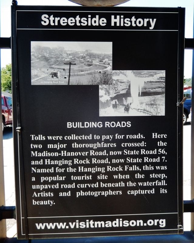
What once was a cow path became a muddy plank road later named the Two Cent Road for the toll charged. A gravel route, it angled southwest across Three Notch Road, a wilderness trail blazed by Indians who marked it slashing three . . . — — Map (db m66741) HM
Jacob Whetzel’s 1818 Trace from Laurel on Whitewater to White River, and the Madison Trail crossed near here. Here Whetzel made camp while cutting the Trace. In 1822 Daniel Loper built the first cabin in Clark Township here. — — Map (db m69355) HM
The 2S1 Gvozdika is a Russian-made 122mm self-propelled howitzer tracked armored vehicle. The first prototype was ready in 1969. The 2S1 entered service with the Soviet Army in the early 1970s and was first seen in public at a Polish Army parade in . . . — — Map (db m180843) HM
The DUKW (collaquially known as Duck) is a six-wheel-drive amphibious truck that was designed by a partnership under military auspices of Sparkman & Stephens and General Motors Corporation (GMC). It was used in World War II for transporting goods . . . — — Map (db m180817) HM
The LVT is a small amphibious landing craft, introduced by the United States Navy, Marine Corps and Army during World War II. Originally intended solely as cargo carriers for ship to shore operations, they rapidly evolved into assault troop and fire . . . — — Map (db m180825) HM
The M114 Command and Reconnaissance Carrier was a tracked armored fighting vehicle, used by the United States Army in Vietnam. It is a lightweight, low-silhouette vehicle designed to be fast and stealthy. It is constructed of aluminum and powered by . . . — — Map (db m180833) HM
The M211 is a very unique vehicle in that it was a transition design between the GMC CCKW of WWII and the more modern M35 RIO. It and the M35 directly competed for contracts in the early 1950s. It served in both Korea and early Viet Nam. The M211 . . . — — Map (db m180832) HM
The Half-track M3 personnel carrier was an armored vehicle used by the United States, the British Empire and the other Allies during World War II and the Cold War. Nearly 43,000 were produced, and supplied to the U.S. Army and Marines, as well as . . . — — Map (db m187325) HM
The M-47 saw short service with US Forces from 1951 to 1953. It was the second tank to be named after General George S. Patton, commander of the U.S. Third Army during World War II and one of the earliest American advocates of tank warfare. It was a . . . — — Map (db m180828) HM
The M8 Light Armored Car was a 6x6 combat vehicle produced by the Ford Motor Company during World War II. It was used by the U.S. and British troops in Europe and the Far East until the end of the war. It remained in use by U.S. Constabulary Forces . . . — — Map (db m187319) HM
Indian and pioneer trail from Anthony’s Ferry (Henderson, Ky.) on Ohio River to Vincennes. Connected with road to Nashville and there with Natchez Trace. Served Illinois trails, north and west, at Vincennes. — — Map (db m99122) HM
This WWII self-propelled artillery vehicle is built on the American Sherman tank hull. It was manufactured in Canada for the British Army, associated Commonwealth forces, and its Allies. It was developed to give the British Army a mobile artillery . . . — — Map (db m187323) HM
Built 1897 across Tippecanoe River by Bellefontaine Bridge and Iron Company of Ohio. Single-span 140-foot iron bridge is last remaining Pratt through truss bridge in county. U.S. Highway 30 bypassed it in 1924. Closed to vehicle traffic 1975. . . . — — Map (db m44919) HM
Welcome! to the Chinworth Bridge Trailhead Lake City Greenway Former Tippecanoe Rest Park
The history of this area is tied very closely to transportation with the Chinworth Bridge (1897) and U.S. Highway 30 (1926). This scenic 2.5 . . . — — Map (db m72546) HM
On September 1, 1912 at a dinner party for automobile manufacturers at the Deutsches Haus in Indianapolis, Carl G. Fisher, President of the Prest-O-Lite Company and father of The Indianapolis 500 unveiled his plan for a highway spanning the country . . . — — Map (db m72547) HM
Honoring 16 million Americans who served and over 405,000 who died in support of freedom, World War II 1941 - 1945
Celebrating the dedication of the National World War II Memorial, Washington, DC, May 29th, 2004
"A Grateful Nation . . . — — Map (db m16275) WM
Was the first "Coast to Coast" road covering 3,389 miles across the U.S.A.
The dream of Hoosier Carl G. Fisher, founder of the Indianapolis 500. The Lincoln Highway Association was established on June 1, 1913.
The Boy Scouts of America . . . — — Map (db m68035) HM
The Lincoln Highway was the first “Coast to Coast” transcontinental highway in the United States constructed from 1913 to 1928 beginning at Times Square in New York City and ending in Lincoln Park in San Francisco. The route spanned . . . — — Map (db m72548) HM
Tony Elliott, born in Warsaw, Indiana 0n January 24, 1961, was an “Indiana Short Track icon”. For good reason. Following in his father’s racing footsteps Tony immersed himself in sprint car racing, competing on local tracks in Warsaw, Gas City . . . — — Map (db m207694) HM
Pioneer Indian trail originally connecting Rock Island and Detroit. Indians and early settlers traversed this route including Black Hawk (1767-1838), Chief of the Sauk Indians. Trail now alternates between US 30 and 330 across Lake County. — — Map (db m204911) HM
A model stretch of object-lesson road built by the Lincoln Highway Association with the co-operation and financial aid of the federal government, the State of Indiana, and Lake County, Indiana, with funds contributed by the United States . . . — — Map (db m213120) HM
Ideal Section
During the first few years of its existence, the Lincoln Highway Association (LHA) worked feverishly to promote the idea of a transcontinental highway. The excitement and enthusiasm of Americans for better roads became well . . . — — Map (db m213124) HM
The Lincoln Highway. United States' first transcontinental highway, constructed 1913-1928, from New York City to San Francisco. Dedicated to the memory of Abraham Lincoln. Conceived by Carl G. Fisher to encourage building "good roads." . . . — — Map (db m213119) HM
Racing Hall of Famer Ray Nichels attended Franklin School, which now houses the Griffith Historical Society. In 1954 Ray and his wife Eleanor established Nichels Engineering, eventually becoming one of auto racing's elite race car building and . . . — — Map (db m226579) HM
Here, the Potawatomi Indian Trail, a southern branch of the old, historic Ft. Wayne - Ft. Dearborn Trail, proceeded in a southwesterly direction through old Lake Station (East Gary), Liverpool, and on past the Indian ceremonial grounds at . . . — — Map (db m202721) HM
Part of a transcontinental trail used by prehistoric peoples of North America, it passed through modern Detroit, Rock Island and Davenport in the Midwest. The trail was important into the 19th century. — — Map (db m231382) HM
The "Ideal Section," a portion of the Lincoln Highway (US 30), was a prototype of construction technology intended to make it the finest road in the world.
The section begins one half mile west of US 41 and extends 1.3 miles westward to Bank . . . — — Map (db m213121) HM
This plaque is dedicated to the history of America's first transcontinental highway, which passed 137 feet south of this spot. A section of Macadam is displayed in the sidewalk. The highway in the Schererville area followed the Sauk . . . — — Map (db m204887) HM
The Lincoln Highway. United States' first transcontinental highway, constructed 1913-1928, from New York City to San Francisco. Dedicated to the memory of Abraham Lincoln. Conceived by Carl G. Fisher to encourage building "good roads." . . . — — Map (db m213118) HM
Meinrad Rumely
Meinrad Rumely was the founder and guiding spirit of the Rumely Companies for more than 50 years. He came to America from Germany in 1848, and in 1853 on this site opened a blacksmith shop that was to grow into a large . . . — — Map (db m43463) HM
How It All Began
The time was 1912. One million plus motor vehicles were in use in America, primarily in urban settings. To that time only eight recorded motor car travelers had ventured a trip across America. Paved roads were . . . — — Map (db m77213) HM
French fur traders came to Northwest Indiana in the 1600's. A natural opening through the forest served as a gateway to the prairies beyond. They called this opening, La Porte, meaning, “the door”, from which the county received its . . . — — Map (db m77215) HM
Sauk (sac) Indian Trail, a southwest fork of the Fort Wayne-Fort Dearborn Trail, was an early route travelled by Indians from Rock Island, Illinois to Detroit, Michigan to collect their annuities from the British for their services in the . . . — — Map (db m211429) HM
You are standing on
the Stagecoach
Trail, an historic
stagecoach route.
From this point, the
trail curves to the
right into the woods.
Stagecoaches stopped here on their way between New Albany
and Terre Haute.
Stagecoaches had to stop . . . — — Map (db m163037) HM
Originally named Sun Valley Speedway, Joe Helpling
built this track in 1947 and was first raced on
July 2, 1948. Since, some of racing's best have run
here, including, A.J. Foyt, Parnelli Jones, Johnny
Rutherford, Tony Stewart, and multiple . . . — — Map (db m231411) HM
1932 National Racing Champion, Bob Carey, was born in Anderson on September 28, 1904. While working at Robert Roof's race shop here in town, young Carey developed a passion for speed and competition, and pleaded for an opportunity to drive. Once . . . — — Map (db m168898) HM
This shaded boulevard, once named Anderson Street, remains a legacy of this city's Gas Boom Era. Bound by German St. (now 7th) on the North and Washington St (now 9th) Southward, the homes of this District attest to the people and events that have . . . — — Map (db m1163) HM
By the early 20th century automobile racing had captured the imagination of the country. At thousands of county fair dirt tracks young drivers, in home built cars, battled weekly for fame and glory. Robert M. Roof was one such youngster. Roof's . . . — — Map (db m175556) HM
Ray Harroun will be remembered always as the winner of the first Indianapolis 500 in 1911. But, despite the acclaim that historic victory brought, he considered himself first and foremost, an engineer. He raced simply to prove his ideas practical . . . — — Map (db m168873) HM
Since about 1670 this oak has been a landmark for a Delaware Indian Trail, for the Fort Wayne Trace, for the Village of Orestes, and for God. — — Map (db m141546) HM
Operated by Augusta Gravel Road Co., circa 1866-1892. First major state road, built in the 1830's, from the Ohio River to Lake Michigan. — — Map (db m563) HM
Nationally Known for its tranquil charm and peaceful elegance, its ironic that many from the roaring, raucous, boisterous world of motorsporting have chosen the serenity of Crown Hill as their final resting place. Some of racing’s most iconic . . . — — Map (db m174868) HM
Although 80 percent of the county's land is used for farming, the city of Auburn was once a major center of the American automobile industry. More than 21 models of cars were created here, including the elegant Auburn and the classic Cord. — — Map (db m238992) HM
More than 200 firms make mobile homes, campers, and other recreational vehicle-related products in Elkhart County. A center for musical instrument manufacturing, the county is known as the "band instrument capital of the world." In sharp contrast to . . . — — Map (db m238854) HM
Fayette County's original forests brought rise to many great early-1900s
cabinet manufacturers and distributors. The county seat of Connersville
was home to eight different automobile manufacturers, including
McFarlan and Lexington. — — Map (db m238647) HM
During the 1830s, the Michigan Road first connected the Great Lakes at Michigan City with the Ohio River. The Michigan Road was Indiana's first major north-south highway. In 1858, the federal government built a stone and brick lighthouse on Lake . . . — — Map (db m238991) HM
Beginning in the early 1900s, the automotive industry in Madison County grew to include production of headlights, taillights, horns, batteries, and other accessories. Also known for its Native American history, the mounds near Anderson are believed . . . — — Map (db m238929) HM
The American Association of State Highway and Transportation Officials dedicates this brick pathway as its 2000 inaugural Legacy Project, designed to promote the spirit of community and transportation partnership. This Legacy Project commemorates . . . — — Map (db m239047) HM
In 1842 former President Martin Vin Buren was unceremoniously toppled from his carriage on the muddy National Road in Plainfield, Indiana. The Hoosier "welcoming committee" was still angry over his veto of a bill to provide much needed funding to . . . — — Map (db m239039) HM
The low, swampy land along the Kankakee River was drained to contribute to Starke County's fertile soil of which 75 percent is used for farming. This tranquil land can be enjoyed by traveling scenic Lincoln Highway through the county. The peaceful . . . — — Map (db m238874) HM
Side A Few names resonate with automotive enthusiast like Stutz. Renowned for their striking appearances, superb handling, and speed, Stutz was America’s first production performance car. The flamboyant, Harry C. Stutz, produced iconic cars . . . — — Map (db m169433) HM
Sitting at the junction of the National Road and the Wabash River, Vigo County has played a vital role in the transportation of goods to and from Indiana markets. Terre Haute means "high ground" and reflects early French influence in the area. Paul . . . — — Map (db m238840) HM
National Old Trail Road in Wayne County is marked by the 18-foot high Madonna of the Trail statue. The National Road was a primary route for immigration into Indiana and provided access to essential eastern markets for Hoosier companies. Two such . . . — — Map (db m238934) HM
The Indiana State Fairgrounds Mile is often lauded for the significant part it has played in Indiana racing history, as well as the nation’s. One of America’s earliest auto racing sites, it gained world renown on June 29th, 1903 when Barney . . . — — Map (db m175593) HM
This milestone marks the crossing of the National and Michigan Roads.
Over these roads came many pioneers, who, by their courage and industry founded the great commonwealth of Indiana.
The one hundredth anniversary of the admission of Indiana . . . — — Map (db m174861) HM
Pioneering motorcyclist and racecar driver Erwin G. Baker (born 1882) moved to Indianapolis circa 1893. He won one of the first motorcycle races at the newly opened Speedway, 1909, and raced in 1922 Indy 500. Baker set numerous speed and distance . . . — — Map (db m128028) HM
There are few better known names in automotive circles world wide than Chevrolet. Millions own and drive the internationally respected cars, but few know that the company and it’s revered name originated with three brothers, Louis, Gaston and . . . — — Map (db m169321) HM
Side A National Road in Marion County
Workers built the National Road through this area in the 1830s, nearly four decades before Irvington’s founding.
A constant stream of travelers on the road drew business to the area. The first commercial . . . — — Map (db m174717) HM
During the bicycle craze of the 1890s, Hoosiers embraced the bike for transportation, recreation, and sport. Women, especially, gained new freedoms and independence. In 1898, Indianapolis businessman Arthur C. Newby and other cycling enthusiasts . . . — — Map (db m210943) HM
This area of the Marian University campus was once known as “Millionaire Row” as some of Indianapolis’ wealthiest men resided here. Perhaps the better label would’ve been, “Founder’s Row”, for three of the four founders of the famed Indianapolis . . . — — Map (db m174886) HM
Estate apartments
has been placed on the
National Register
of Historic Places
by the United States
Department of the Interior
May 1997 — — Map (db m231514) HM
An Important Road
The National Road is a true American icon, conceived by George Washington, authorized by Thomas Jefferson, and traveled by Abraham Lincoln.
In 1806 construction of the National Road was approved by the US Congress to . . . — — Map (db m232658) HM
You are standing on Washington Street—the route of the Historic National Road in Indiana. In the early 19th century, this broad street had no sidewalks and was lined with log buildings and frame taverns that crowded near the newly constructed state . . . — — Map (db m132794) HM
After the Civil War, industrialization and population growth greatly expanded Indianapolis. Merchants, doctors, and lawyers, including the future President Harrison, purchased lots along the norther city limits near today's 10th Street and . . . — — Map (db m238641) HM
The Boyle Racing Headquarters housed one of the most significant teams in open wheel racing history. One of the first dedicated race shops in an era when most teams worked from small garages. It was built in 1930 and subsequently rented by Mike . . . — — Map (db m235284) HM
On December 31, 1821, a 78-mile state road was authorized from the Ohio border to Indianapolis through Brookville, to be built with required citizen labor. Commissioners filed a survey report June 24, 1822 for the Brookville State Road. On January . . . — — Map (db m44713) HM
The “Wizard of Indy” is an apt title for master car builder, A.J. Watson. He arrived at the Indianapolis Motor Speedway in 1948 and in 1950 qualified the low budget “Pots and Pans Special”, built by a group of fellow Glendale, California . . . — — Map (db m174964) HM
Constructed in 1909, the Speedway has contributed significantly to the advancement of automotive technology and development of safety devices. It is unchallenged as the world's oldest continuously operated race course and the site of the largest . . . — — Map (db m228) HM
Few in motorsports history have impacted as many forms of racing as Floyd “Pop” Dreyer. His creativity influenced disciplines as diverse as motorcycles, sprint cars and Indianapolis cars. After riding his brother’s Pope motorcycle for a year, . . . — — Map (db m174956) HM
During westward migration along old National Road, thousands of horses were watered at this widely known public watering place. Town pump and trough maintained as community service by Bridgeport Lodge No. 162, F. & A. M., organized 1854. — — Map (db m174953) HM
Street Railway
Indianapolis' first street railway opened in 1864 and the system expanded with the growth of the city over the next several decades. The early streetcars were drawn by mules or horses until the system was electrified between . . . — — Map (db m132829) HM
When the gentleman smoking the pipe glanced at the camera in 1937, he had no idea that people in future generations would be glancing at him and looking past him into Indianapolis history.
Perhaps our pipe smoker purchased his suit at one of . . . — — Map (db m132775) HM
Side 1:
Entrepreneur James Allison helped establish Indianapolis Speedway Team Co., 1915, and later built a precision machine shop here near speedway to improve race cars. Upon U.S. entry in WWI, 1917, 500-mile race was suspended and he . . . — — Map (db m106446) HM
The idea that America needed better roads did not originate with the invention of the automobile, but with bicyclists known as "wheelmen." Challenged by rutted roads of gravel and dirt and faced with antagonism from horsemen, wagon drivers, and . . . — — Map (db m184845) HM
The Lincoln Highway Association A New Generation The original Lincoln Highway Association dissolved, its final activities occurring in the early 1940s. As the interstate highway system and superhighways bypassed the small towns and . . . — — Map (db m244096) HM
(Side One)
Historic Crossroads of America
Marshall County has been called the Crossroads of America. The Lincoln Highway (the Lincoln’s second alignment constructed in the mid-1920s), the Michigan Road (Indiana’s first state . . . — — Map (db m75489) HM
Where you are now standing is an historic river ford on the Goshen - Logansport trail, a vital link between early population centers in 19th century Indiana. This scene depicts Sanford C. Cox account of he and his companion crossing the river on the . . . — — Map (db m62663) HM
The name Lost Sister refers to Frances Slocum who was kidnapped by Delaware Indians from her Quaker Pennsylvania parents in 1778. She was welcomed into the Miami community and given the name Mahkoonsihkwa, or Little Bear Woman, due to her . . . — — Map (db m215038) HM
Howard Samuel “Howdy” Willcox, the winner of the 1919 Indianapolis 500, was born in Crawfordsville on June 24, 1889. Drawn to auto racing, “Howdy” became one of the brightest stars of the dynamic new sport. His intense talent, charismatic charm, . . . — — Map (db m175826) HM
A Trail from Whitewater River at Laurel terminated here at the Bluffs of White River. Cut in 1818 by Jacob Whetzel, it was the first east-west road into central Indiana. — — Map (db m66830) HM
You are standing on the original brick street to West Baden Springs Hotel, installed when the hotel was built in 1902. In the early 1900s, over half of the streets in the towns of French Lick and West Baden were made of bricks, numbering in the . . . — — Map (db m194999) HM
Few race tracks in America possessed the
renown, mystique, and sense of awe as Jungle
Park Speedway. Carved from the dense Indiana
woods in 1926, by Earl Padgett, the half mile
track soon became a hotbed for Midwest racing,
attracting . . . — — Map (db m161462) HM
The State Sanatorium Covered Bridge is a single-span Kingpost Truss Burr Arch structure with a span length of 154 feet. It was constructed in 1913 by Joseph A. Britton. The bridge is listed on both the National Register of Historic . . . — — Map (db m164851) HM
Crossed White River at a nearby ford. It was made by migrating buffalo herds. The trace ran from Vincennes to Louisville and was the only through trail in pioneer days. — — Map (db m23217) HM
Opened to traffic by the Dunes Highway Association, November 14, 1923.
A.S. Hess, President
W.E. Jewell, Vice President
O.B. Johnson, 2nd Vice President
Z.B. Campbell, Treasurer
W.K. Greenebaum, Secretary — — Map (db m10762) HM
The Lincoln Highway was the first “Coast to Coast” road covering 3,389 miles across the USA. It was the dream of Hoosier Carl G. Fisher.
In 1913. The Lincoln Highway Association (LHA) announced that . . . — — Map (db m244097) HM
"Are we there yet?" For emigrants traveling along the National Road in Indiana, the answer was a resounding "YES!"
Many of us move for the same reasons: new jobs, attractive settings, and nice houses. In the 19th century, thousands moved west . . . — — Map (db m233272) HM
Side A
Winchester Speedway is one of the most significant, historic short tracks in the United States. It opened in 1914 under the name Funk’s Speedway, and has held races continuously since. Known as the “World’s Fastest ½ . . . — — Map (db m138726) HM
Extending from Michigan City to the Ohio River at Madison. Begun by the state in 1832 with funds obtained from sale of land granted by the Potawatomi Indians. Opened northern part of state to settlers. — — Map (db m74032) HM
This trail was cut about 1808, by John Berry (1777-1835). It began at Napoleon, ran west to Flat Rock and Blue Rivers, and thence northward into central Indiana. The Trace branched off the Brownstown-Brookville Road. — — Map (db m45838) HM
On Aptil 23, 1978, a plane carrying USAC officials left the Trenton, New Jersey Championship race, bound for Indianapolis. It crashed near here. All 9 aboard died. The loss aversely impacted American racing’s echelon for decades. Those lost; Ray . . . — — Map (db m169290) HM