By Rev. Ronald Irick, March 8, 2021
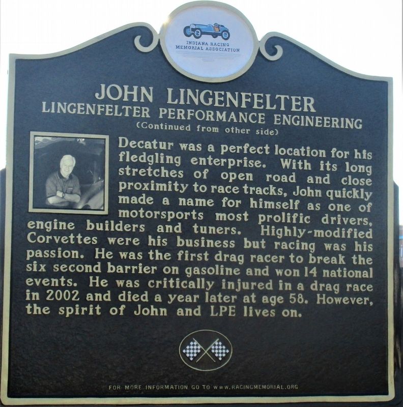
John Lingenfelter Marker
| On Winchester Road, 0.2 miles west of North 13th Street (U.S. 27), on the left when traveling west. |
| On North 400 East, 0.1 miles East North (U.S. 224), on the left when traveling north. |
| Near Coldwater Road at E. Ludwig Road, on the right when traveling south. Reported missing. |
| On E. Main Street, on the left when traveling east. |
| On Coliseum Blvd (Indiana Route 930) east of Parnell Avenue, on the right when traveling east. |
| On North Wells Street, on the right when traveling north. |
| On Indiana Route 37 at Antwerp Road, on the right when traveling east on State Route 37. |
| On Hoagland Road just east of Poplar Drive, on the right when traveling east. |
| On U.S. 24 at Harper Road, on the right when traveling east on U.S. 24. |
| On Lincoln Highway East west of Broadway Street, on the right when traveling west. |
| On Michigan Road (U.S. 421) at Valley Meadow Drive, on the left when traveling north on Michigan Road. |
| On Michigan Street (a.k.a.: St Rd 29) at East 7th Street, on the right when traveling north on Michigan Street (a.k.a.: St Rd 29). |
| On County Road N 700 W north of County Road W 675 N, on the right when traveling north. |
| On Road N 700 W north of Road W 675 N, on the right when traveling north. |
| On County Road N 700 W north of County Road W 675 N, on the right when traveling north. |
| On Road N 700 W north of Road W 675 N, on the left when traveling north. |
| On Indiana Route 29 near County Road 400, on the right when traveling south. |
| On State Road 29 north of County Road E400N, on the left when traveling north. Reported permanently removed. |
| On East National Avenue (U.S. 40) west of Forest Avenue (Indiana Route 59), on the left when traveling east. |
| On Park Street (County Route 1250N) at Local Route 900E, on the right when traveling east on Park Street. |
| On NW 1st Street at West Maple Street, on the left when traveling south on NW 1st Street. |
| On County Road S 300W, 0.1 miles north of U.S. 50, on the right when traveling north. |
| On Indiana Route 48, 0.2 miles west of Louden Road, on the left when traveling west. |
| On Walnut Street north of East Center Street, on the right when traveling north. |
| On East Washington Street near North Broadway Street, on the right when traveling east. |
| On City Pond Park Drive east of County Road 500. |
| On Gordon M. Buehrig Place just east of South Wayne Street, on the left when traveling east. |
| On Wayne Street at Gordon M Buehring Place, on the right when traveling north on Wayne Street. |
| On Wayne Street just north of Gordon M Buehring Place, on the left when traveling north. |
| On Wayne Street at Gordon M. Buehrig Place, on the left when traveling south on Wayne Street. |
| On Wayne Street at Gordon M Buehring Place, on the right when traveling north on Wayne Street. |
| On Wayne Street at Gordon M Buehring Place, on the left when traveling north on Wayne Street. |
| On South Van Buren Street at Walnut Street, on the left when traveling south on South Van Buren Street. |
| On Wayne Street at Gordon M Buehring Place, on the right when traveling north on Wayne Street. |
| On Wayne Street at Gordon M Buehring Place, on the left when traveling north on Wayne Street. |
| On Wayne Street at Gordon M Buehring Place, on the left when traveling north on Wayne Street. |
| On South Van Buren Street just north of Walnut Street, on the right when traveling north. |
| On Wayne Street at Lincoln Street, on the right when traveling north on Wayne Street. |
| On South Van Buren Street at Walnut Street, on the left when traveling south on South Van Buren Street. |
| On Gordon M Buehrig Place just east of Wayne Street, on the left when traveling east. |
| On Wayne Street north of Gordon M Buehring Place, on the left when traveling north. |
| On South Van Buren Street south of Walnut Street, on the left when traveling south. |
| On River Greenway, 0.2 miles south of County Road 60, on the left when traveling east. |
| On River Greenway, 0.3 miles south of County Route 60, on the left when traveling south. |
| On Indiana Route 28 at County Route 875, on the right when traveling west on State Route 28. |
| On East Elm Street (County Road 850N) at South Sycamore Street (County Road N600W), on the right when traveling east on East Elm Street. |
| Near Cardinal Greenway Trail at Wheeling Avenue, on the right when traveling south. |
| Near East Jackson Boulevard east of Marine Avenue, on the right when traveling east. |
| On E. Beardsley Avenue east of Montessori Drive, on the right when traveling east. |
| On U.S. 33 at Lincoln Avenue, on the right when traveling south on U.S. 33. |
| On East 5th Street at North Eastern Avenue (Indiana Route 1), on the right when traveling east on East 5th Street. |
| On State Street, 0.2 miles south of West Daisy Lane, on the right when traveling south. |
| On East Market Street at State Street, on the right when traveling east on East Market Street. |
| On U.S. 41 at State Road 32, on the right when traveling south on U.S. 41. |
| On U.S. 136 at South Layton Station Road, on the left when traveling west on U.S. 136. |
| On West 2nd Street at South Maple Street, on the left when traveling west on West 2nd Street. |
| On East 2nd Street at Sugar Street, on the right when traveling west on East 2nd Street. |
| On 1st Street at South Mill Street, on the left when traveling west on 1st Street. |
| On Toner Street (State Road 121) at Main Street, on the left when traveling north on Toner Street. |
| On Duck Creek Crossing, on the left when traveling west. |
| On North Old US Highway 31 north of County Road E 350 N, on the right when traveling north. |
| On U.S. 31 south of County Road W 375 N, on the right when traveling south. |
| On Old U.S. 31 north of County Road 350N, on the right when traveling north. |
| On West Broadway Street (Indiana Route 65) at North West Street, on the left when traveling east on West Broadway Street. |
| On South Main Street just south of West Washington Street (County Road 950S), on the left when traveling north. |
| On 4th Street south of High Street, on the right when traveling east. |
| On South Main Street (Indiana Route 22) south of Railroad Street, on the left when traveling north. |
| On Forest Park Driveway, 0.2 miles west of Cicero Road, on the left when traveling west. |
| On Conner Street (State Road 32/38), on the left when traveling east. |
| On Maple Avenue west of South 9th Street, on the right when traveling west. |
| On Allisonville Road, on the right when traveling west. |
| On 9th Street at Maple Avenue, on the left when traveling south on 9th Street. |
| On South State Street (U.S. 40) at South State Street (Indiana Route 9), on the left when traveling west on South State Street. |
| On North Green Street (Indiana Route 267) at Interstate 74, on the right when traveling south on North Green Street. |
| On Foxwood Drive just west of South Locust Lane, on the left when traveling west. |
| On West Main Street (U.S. 40) west of West Street, on the right when traveling east. |
| On East Main Street (U.S. 40) at North Washington Street, on the right when traveling west on East Main Street. |
| Near East Main Street south of South Howard Street. |
| Near East Vaile Street at South Market Street, on the right when traveling west. |
| Near West Sycamore Street. |
| On South Webster Street south of West Ricketts Street, on the right when traveling south. |
| On U.S. 31 at East Boulevard on U.S. 31. |
| On East Boulevard at South Goyer Road, on the right when traveling west on East Boulevard. |
| On Walk of Excellence at South Main Street, on the right when traveling east on Walk of Excellence. |
| On North Jefferson Street at East Washington on North Jefferson Street. |
| On Jefferson St., 0.1 miles north of Riverside Dr., on the right when traveling south. |
| On East Park Drive (U.S. 224) at Warren on East Park Drive. |
| On West Park Drive (Business U.S. 24) 0.1 miles west of Dimond Street, on the right when traveling west. |
| On 1st Street at South Main Street, on the left when traveling east on 1st Street. |
| Near S. Main Street (County Road S310W) south of Water Street, on the right when traveling south. |
| On West Bridge Street at South Union Street (Indiana Route 1), on the right when traveling east on West Bridge Street. |
| On West Walnut Street, on the right when traveling south. |
| On West Arch Street at U.S. 27, on the right when traveling east on West Arch Street. |
| On East Vaughn Drive just west of Mulberry Street, on the right when traveling east. |
| On West Vaughn Drive just east of Central Avenue, on the right when traveling east. |
| On East Main Street (Ohio River Scenic Byway) (U.S. 421) just east of Jefferson Street (U.S. 421), on the right when traveling west. |
| On East 2nd Street just east of Jefferson Street, on the right when traveling east. |
237 entries matched your criteria. The first 100 are listed above.
Next 100 ⊳