On Auburn Riverwalk, 0.1 miles north of Court Street (U.S. 202), on the right when traveling north.
Before it was L-A, this place was Amitgonpontook, which means "the place to dry the fish at the falls." For generations Wabanakis harvested migrating fish each spring. In 1794 Perepol described how travel made this place a part of . . . — — Map (db m186016) HM
On Auburn Riverwalk, 0.1 miles north of Great Falls Plaza, on the left when traveling east.
Rivers were the transportation and power for Maine's logging industry from the first sawmill in 1630 in Berwick until 1974. Lewiston's first sawmills were located near the Great Falls. Throughout the year, hardy loggers cut the trees . . . — — Map (db m186026) HM
In Memory of Rodney “Rocky” Bonney. Auburn police officer Rodney “Rocky” Bonney died in the line of duty attempting to rescue a youth from these frigid waters. April 06, 1981.
“In Valor There is Hope” — — Map (db m1048) HM
On Auburn Riverwalk just east of Main Street (Maine Route 136), in the median.
Welcome to Bonney Park
Located in the heart of downtown Auburn, Bonney Park was named in remembrance of fallen Police Officer Rodney "Rocky" Bonney. Bonney Park features playground equipment and great views of the Androscoggin River. Bonney . . . — — Map (db m185973) HM
The Lewiston-Auburn Railroad Bridge was erected in 1909 and served as a vital link to the downtown. It also provided the connection for thousands of Canadian, Irish, Polish and other immigrants to the area. Recognizing the bridge’s historic . . . — — Map (db m1050) HM
On Auburn Riverwalk, 0.2 miles south of Court Street (U.S. 202), on the left when traveling north.
The banks of the river are home to a variety of plants and animals. If you take the time to walk slowly along its shores, you will catch a glimpse of a once-vast forest ecosystem known as "The Northern Hardwood Forests." These . . . — — Map (db m186012)
On Main Street (Maine Route 136) just south of Vine Street, on the left when traveling north.
Squire Edward Little is called the "father" of Auburn and Lewiston. He inherited vast tracts of land from his father. In 1826, at the age of 53, he moved to Danville (now Auburn) and built what his father called an "extravagant" . . . — — Map (db m185965) HM
On Main Street (Maine Route 136) 0.1 miles south of Court Street (U.S. 202), on the right when traveling north.
Festival Plaza was created as part of the 1997 Auburn Downtown Action Plan for Tomorrow (ADAPT) visioning and revitalization initiative. As designed by Boston's ICON Architecture, Festival plaza establishes a vibrant . . . — — Map (db m185953) HM
On Auburn Riverwalk, 0.2 miles Court Street (U.S. 202), on the right when traveling north.
These jagged, rocky outcrops that we call the "Great Falls" are actually a combination of three distinct rock formations. The oldest rocks were laid down from 20 to 435 million years ago as continents collided! Over time, they slowly . . . — — Map (db m186020)
On Auburn Riverwalk just north of Great Falls Plaza, on the right when traveling north.
The Androscoggin River's great power has played a tremendous role in the development of the Lewiston-Auburn communities. The river drops more than 1,500 feet along its journey from the Rangeley Lakes, one of the steepest gradients of . . . — — Map (db m186023) HM
Near Auburn Riverwalk, 0.1 miles north of Main Street (Maine Route 136), on the right when traveling north.
As with many American rivers that fueled the Industrial Revolution, the Androscoggin has a complex history. It was once considered one of the "Top Ten" most polluted rivers in the country. The paper mills along the river accounted . . . — — Map (db m185995) HM
On Main Street (U.S. 202) at Lincoln Street, on the right when traveling west on Main Street.
When the U.S.S. Maine was commissioned in 1895, it was the first modern American battleship, and the first modern U.S. Navy warship to be built in an American shipyard of materials and components manufactured in the United States. The Maine . . . — — Map (db m186041) HM WM
Welcome to part of the Wabanaki homeland, Wabanakis—the People of the Dawnland—are the Indigenous peoples of northern New England and southeastern Canada. The four federally recognized peoples in Maine are the Penobscots, . . . — — Map (db m185980) HM
On Main Street (U.S. 202) at Lincoln Street, on the right when traveling west on Main Street.
Lewiston Falls, the upper falls of Pejepscot, "Amitgonpontook." Favorite resort of the Indians for hunting and fishing. Home of Anasagunticooks, chief fort and village of Warumbee on west bank. Coast-to-Canada trail and crossroads for Sebago, . . . — — Map (db m186037) HM
On Beech Street at Oxford Street, on the right when traveling east on Beech Street.
If you've ever seen a working factory, you know they require a lot of power. In Lewiston in the 1800s, the best source was the Androscoggin River. Canals extended that power beyond the riverbanks, making it possible to develop . . . — — Map (db m185983) HM
On Main Street (Route 202) at Lincoln Street, on the right when traveling west on Main Street.
Lewiston's industry began with the Harris sawmill beside the falls. In 1809, Josiah Little's family built a large wooden building for saw, grist, and fulling mills under one roof. When the mill burned in 1829, the Littles built a . . . — — Map (db m186038) HM
On Oxford Street just north of Beech Street, on the right when traveling north.
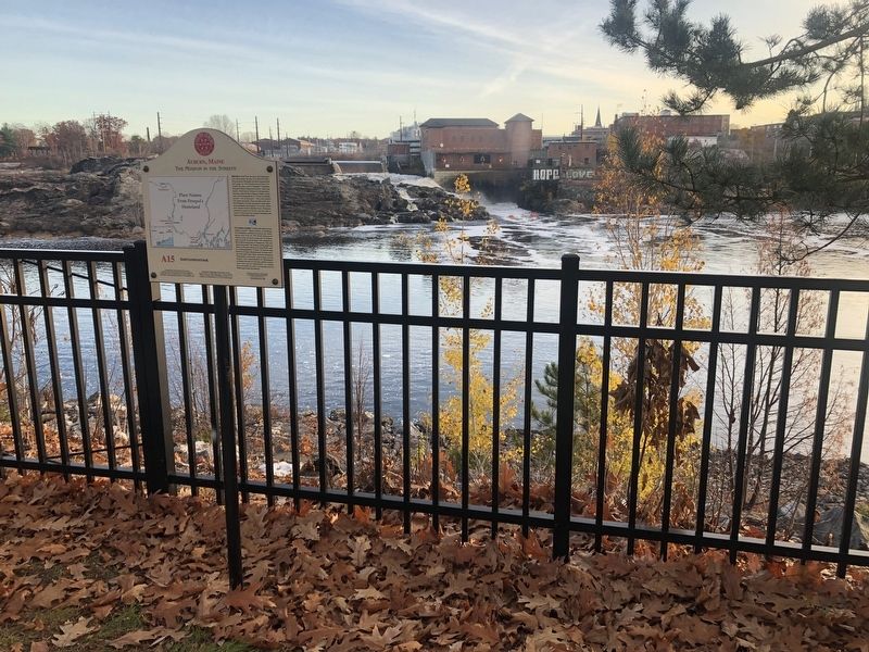
Welcome to Lewiston's Museum in the Streets® historic walking tour.
Along this trail you will discover the rich heritage of Maine's second largest city. Illustrated panels guide you along the Androscoggin River and through the . . . — — Map (db m185985) HM
On Lisbon Street (Maine Route 196) 0.1 miles south of Journal Alley, on the right when traveling north.
Welcome to Lewiston's Museum in the Streets® historic walking tour.
Along this trail you will discover the rich heritage of Maine's second largest city. Illustrated panels guide you along the Androscoggin River and through the . . . — — Map (db m186042) HM
On Main Street (U.S. 202) at Lincoln Street, on the right when traveling west on Main Street.
To those native sons and daughters of the great state of Maine who made the supreme sacrifice while serving their country on active duty in the United States Navy and Marine Corps during times of armed conflict.
On Armed Forces Day, May 17, . . . — — Map (db m186033) HM WM
Near Dufour Street north of Church Street, on the left when traveling north.
English:
Wabanaki Native Americans were this area's original inhabitants, hunting, gathering and traveling along these waterways. In the 1780's, the Upper St. John Valley began to be settled by French-Canadians and Acadians. By . . . — — Map (db m148193) HM
On West Main Street (U.S. 1) at Clair-Fort Kent International Bridge, on the right when traveling west on West Main Street.
English:
To St. John Valley residents, the river was never a dividing boundary. In 1842, distant governments finally agreed to divide the U.S. and Canada along the St. John River. Generations before, Acadians had settled the . . . — — Map (db m148168) HM
On East Main Street (U.S. 1) at River Street, on the right when traveling south on East Main Street.
English:
Before bridges, railways, and paved roads, the St. John River unified communities, culture, and commerce across the entire Valley — north and south. The genealogical roots of many Valley families cross the river . . . — — Map (db m148184) HM
Originally designed and built 1892 by John A. Roebling's Sons Co. for mill workers to cross the river from new housing in Topsham to the Cabot Mill in Brunswick. The bridge has served generations of citizens of all ages between Brunswick and . . . — — Map (db m51968) HM
Near Shore Road south of Littlejohn Road, on the right when traveling north.
This building was completed in 1909 for use by unmarried officers of the Coast Artillery Corps stationed at Fort Williams. Visiting officers or married officers without their families might also reside in the quarters. The structure was built to . . . — — Map (db m186117) HM
Near Shore Road south of Littlejohn Road, on the right when traveling north.
THis building was completed in 1909 for use by unmarried officers of the Coast Artillery Corps stationed at Fort Williams. Visiting officers or married officers without their families might also reside in the quarters. The structure was built to . . . — — Map (db m186116) HM
In this bicentennial year, 1765-1965, of Cape Elizabeth, Maine, the town dedicates this plaque in honor of the United States Coast Guard on the 175th anniversary of its founding and the commissioning of the light by the President of the United . . . — — Map (db m161818) HM WM
Near Shore Road south of Littlejohn Road, on the right when traveling north.
This building was completed in 1911 under the direction of the Quartermaster Corps of the U.S. Army for use by a field officer (colonel, lieutenant colonel, or majro) of the Coast Artillery Corps and his family stationed at Fort Williams. It was . . . — — Map (db m186114) HM
Near Shore Road south of Littlejohn Road, on the right when traveling north.
This building was completed in 1911 under the direction of the Quartermaster Corps of the U.S. Army for use by a field officer (colonel, lieutenant colonel, or majro) of the Coast Artillery Corps and his family stationed at Fort Williams. It was . . . — — Map (db m186115) HM
This former military installation, begun in 1873 and known as The Battery at Portland Head, was a sub-post of Fort Preble until 1898 when it became a separate independent fort. It was designated Fort Williams in honor of Brevet Major General Seth . . . — — Map (db m23389) HM
Near Shore Road south of Littlejohn Road, on the right when traveling north.
This building was completed in 1934 for the 240th Coast Artillery Regiment of the Maine National Guard by the Quartermaster Corps. The shed was used to house two of the regiment's four mobile 155mm guns and the large Holt crawler tractor used to . . . — — Map (db m186105) HM
Near Shore Road south of Littlejohn Road, on the right when traveling north.
This building was completed in 1934 for the 240th Coast Artillery Regiment of the Maine National Guard by the Quartermaster Corps. The shed was used to house two of the regiment's four mobile 155mm guns and the large Holt crawler tractor used to . . . — — Map (db m186106) HM
Near Shore Road south of Littlejohn Road, on the right when traveling north.
"Keepers of the Light"
1791 John K. Greenleaf •
1796 Dave Duncan •
1976 Barzillai Delano •
1820 Joshua Freeman •
1840 Richard Lee •
1849 John F. Watts •
1853 John W. Coolidge •
1854 James S. Williams •
1854 James Delano • . . . — — Map (db m186104) HM WM
Near Shore Road south of Littlejohn Road, on the right when traveling north.
The Militia Storehouse was built in 1915 by the Quartermaster Corps and was assigned to the Maine National Guard. The concrete building was used by the 240th Coast Artillery Regiment for storage of tents, bunks, and other equipment required during . . . — — Map (db m186107) HM
Near Shore Road south of Littlejohn Road, on the right when traveling north.
The Militia Storehouse was built in 1915 by the Quartermaster Corps and was assigned to the Maine National Guard. The concrete building was used by the 240th Coast Artillery Regiment for storage of tents, bunks, and other equipment required during . . . — — Map (db m186111) HM
Near Shore Road south of Littlejohn Road, on the right when traveling north.
This Mining Casemate was constructed in 1891, but it was rebuilt in 1903, enlarged in 1907, and modernized during World War II. The function of the casemate was to control the minefield in the main channel, which was laid during the Spanish-American . . . — — Map (db m186118) HM
Since its commission by George Washington in 1790, Portland Head Light remains an enduring symbol of the rugged, solid characteristics of a magnificent coastline and proud people weathering the challenges of nature and time.
In observance of . . . — — Map (db m41841) HM
Near Shore Road south of Littlejohn Road, on the right when traveling north.
Officers Killed in Action
Lt. James G. Early (Commander) • Lt. John R. Laubach • Lt. Ambrose O. Vanderheiden • Ens. Seth E. Chapin • Ens. Roy F. Swan
Enlisted Crew Killed in Action
John J. Alexander F2c •
James O. Brown CGM • . . . — — Map (db m186103) WM
In memory of the officers and crewmen of the U.S. Navy's Eagle Class Sub-Chaser U.S.S. Eagle-56 (PE-56) torpedoed and sunk by the German U-boat U-853 approximately nine miles southeast of this location on Monday, 23 April 1945 with the loss of . . . — — Map (db m50332) WM
On Sebago Lake State Park Road, 1.9 miles east of U.S. 302, on the left when traveling north.
This lock, originally built of stone masonry in 1830, was a vital link in the 50 mile long waterway from Portland Harbor to Harrison at the head of Long Lake until the advent of the railroad in 1869. At one time 100 “canal boats” were . . . — — Map (db m59436) HM
On Wharf Road just west of Sunset Road, on the left when traveling west.
You have landed on one of the fourteen Main Coastal Island which have year-round communities with public schools. Once there were three hundred such communities.
Cliff Island lies at a Latitude of 43° 42' North and a Longitude of 70° 8' . . . — — Map (db m186394) HM
On Congress Street just north of Elm Street, on the left when traveling north.
In memory of
Asa Clapp
A seaman of the American Revolution
Merchant, an upbuilder of Portland
1762 ✠ 1848
Asa William Henry Clapp
Citizen of Portland
A conservator of its interests
Member of
the Congress of . . . — — Map (db m185934) HM WM
On Back Cove Trail, 0.1 miles east of Baxter Boulevard when traveling west.
Explore Baxter Trail, a 3.25 mile walking trail from here to Evergreen Cemetery. Discover how the many contributions of two wealthy visionaries, Mayor James Phinney Baxter and his son Governor Percival Proctor Baxter, continue to . . . — — Map (db m186460) HM
On Commercial Street (U.S. 1) at Franklin Arterial (U.S. 1), on the right when traveling north on Commercial Street.
Landing spot for many passengers on the Underground Railroad and embarkation point for their transit to Canada and England.
Anti-slavery sympathizers were well-organized to greet stowaways from Southern cargo vessels, find them safe housing . . . — — Map (db m20614) HM
On Middle Street at India Street, on the right when traveling west on Middle Street.
Hack stand of Charles H.L. Pierre, 29 Middle Street. Charles H.L. Pierre led the African American men, who rescued the stowaway aboard HMS Albion Cooper in the Fall of 1857.
In the mid-1800s, professional opportunities for freed Blacks were . . . — — Map (db m185939) HM
Panel 1:
[rendering of Rear Admiral James Alden]
Born in Portland March 31, 1810
Died in San Francisco Feb 6, 1877
Panel 2: [rendering of a mariner's sextant] Intrepid Explorer
Skilful Hydrographer
Cartographer of the . . . — — Map (db m72995) HM WM
On Back Cove Trail, 0.1 miles east of Baxter Bouleard, on the right when traveling east.
Welcome to Back Cove Trail: An urban ecosystem
Over a hundred years ago, this trail was the dream of one man-James Phinney Baxter.
In 1893, Baxter after a long and very successful business career, became Portland's mayor . . . — — Map (db m186459) HM
In memory of three thousand men and women who gave their lives in the Arctic Campaign 1941-1945 on convoys to and from Russia
We will remember them
May 2000 This granite is given by the people of Murmansk City, Russia to the people of . . . — — Map (db m105684) WM
On September 5, 1813 off Monhegan Island on the coast of Maine, the American brig “Enterprise” commanded by 28 year old Lt. William Burrows engaged in battle with the British brig “Boxer” commanded by 29 year old Captain Samuel Blythe. Both ships . . . — — Map (db m129636) HM
On Eastern Promenade at Morning Street, on the right when traveling north on Eastern Promenade.
In 1866, a year after the Civil War ended, these guns (technically, called 4.5-inch Siege Rifles) were cast in Pittsburgh by the Fort Pitt Foundry. They could fire a 25-to 30-pound ball 3,200 — nearly 2 miles! In the early 1900s, they were . . . — — Map (db m186367) HM
On Eastern Promenade at Morning Street, on the right when traveling north on Eastern Promenade.
The importance of Portland harbor over two centuries is clear from the fortifications you see from here. Behind you, lies Fort Allen — an 1814 earthworks. Three granite Civil War forts remain visible. Fort Gorges rises in the harbor. Fort . . . — — Map (db m186376) HM
On Eastern Promenade north of Morning Street, on the right when traveling north.
Displayed here are the U.S.S. Portland CA-33's after mast, bridge shield, and ship's bell. This memorial honors one of the most-decorated ships of World War II, her crew, and the men who died aboard the Portland and other U.S. Navy . . . — — Map (db m186379) HM
On Congress Street near North Street, on the right when traveling north.
Portland Observatory
has been designated a
National Historic Landmark
This site possesses national significance
in commemorating the history of the
United States of America.
The Observatory is the nation's only remaining . . . — — Map (db m50418) HM
On Congress Street just north of Kellogg Street, on the right when traveling north.
One of the earliest marine signal stations in the United States, this tower is unique in its engineering design and construction and contributed to the prosperity of Portland Harbor as a vital center of maritime commerce during the "Golden Age of . . . — — Map (db m186397) HM
On Eastern Promenade at Morning Street, on the right when traveling north on Eastern Promenade.
February 15, 1898 • Havana Harbor, Cuba
U.S.S. Battleship Maine explodes killing 260
The event is used by hawkish Assistant Secretary of the Navy, Theodore Roosevelt to pressure President McKinley into the Spanish-American . . . — — Map (db m186370) HM
On Eastern Promenade at Morning Street, on the right when traveling north on Eastern Promenade.
Henry Wadsworth Longfellow
Portland native Longfellow (1807-1882) often walked up Munjoy Hill to this park from his home nearby on Congress Street. The poet, like countless others over the centuries, stood here relishing the timeless — and . . . — — Map (db m186377) HM
On Eastern Promenade at Morning Street, on the right when traveling north on Eastern Promenade.
In the 1800s, this panoramic view could only be admired while standing in a field strewn with ash heaps and boulders. At the turn of 19th century, City Engineer William Goodwin created a plan for this park, whic Mayor James P. Baxter brings . . . — — Map (db m186363) HM
On Commercial Street (U.S. 1A) just south of Franklin Street (U.S. 1A), on the left when traveling south.
By the summer of 1866, Portland was the largest commercial shipping port in the nation. Industries sprouted up everywhere. Much of their was simply dumpted into rivers, streams, and directly into the Bay.
Few realized that we were . . . — — Map (db m186353) HM
On Commercial Street (U.S. 1A) just south of Franklin Street (U.S. 1A), on the left when traveling south.
Native Americans harvested this rich estuary, camping on Casco Bay islands to hunt, fish, and dig clams.
Prehistoric spear and harpoon points, fish bones, and shell heaps found on Casco Bay islands help trace ancient peoples' late winter, . . . — — Map (db m186360) HM
On Commercial Street (U.S. 1A) just south of Franklin Street (U.S. 1A), on the left when traveling south.
Today, you see a healthier Casco Bay
"Whe Ed Muskie laid out the nation's framework for proection of the human environment, it was the political equivalent of splitting the atom."
Leon G. Billings, . . . — — Map (db m186352) HM
On Thames Street north of Hancock Street, on the right when traveling north.
Measuring nine feet across, this propeller is from the Tug Stamford which was built in 1951 as the Thomas Tracy, then renamed in 1971 to the Stamford. In 1998, the tug was acquired by the Portland Tugboat and Shipbuilding Co. of Portland, Maine, . . . — — Map (db m105980) HM
On Fort Road near McKernan Drive, on the right when traveling north.
Dedicated to the
men and women of
the Coast Artillery Corps
who defended Portland Harbor
at Fort Preble in five wars
from 1808 through 1945 — — Map (db m55602) WM
On Fort Road just south of McKernan Drive, on the right when traveling north.
Dedicated to the men and women of the Coast Artillery Corps who defended Portland Harbor at Fort Preble in five wars from 1808 through 1945. — — Map (db m186123) HM WM
On Slocum Drive west of Fort Road, on the right when traveling west.
In December, 1940, William Newell, president of Todd-Bath Iron, won a British contract to construct a seven-berth shipyard at Cushing Point and to build thirty 10,000-ton cargo vessels. On the mudflat site, Newell had constructed a cofferdam to . . . — — Map (db m186132) HM
On Fort Road near Campus Center Drive, on the right when traveling north.
This area is the site of Fort Preble, also known as Fort Hancock during the Revolutionary War, a temporary fort. Fort Preble was begun in 1808 during the administration of Pres. Jefferson and completed before the War of 1812. It was named for . . . — — Map (db m55568) HM
This scenic point of land overlooking Portland Harbor, where Bug Light Park stands today, was once home to a sprawling World War II Shipyard that covered 140 acres of land, including over 60 buildings, and had the capacity to build up to 13 ships . . . — — Map (db m50474) HM
Shipbuilding has been an important part of South Portland’s economy since colonial times. Small vessels built prior to the Revolutionary War were used for fishing and the coasting trade which ranged from the Kennebec River to Virginia. During the . . . — — Map (db m55678) HM
On Slocum Drive west of Fort Road, on the right when traveling west.
A major revival of shipbuilding took place here in the four years just prior to and during World War II. Cargo ships, the British Ocean series and the United States Liberty ships, were produced by the Todd-Bath Iron Shipbuilding . . . — — Map (db m186129) HM
In the mid-1800s, when South Portland was still a part of Cape Elizabeth, its waterfront appeared to be a continuous line of bustling yards building and repairing ships. From Butler on Turner's Island to Knight and Blanchard in Knightville to . . . — — Map (db m50413) HM
Todd-Bath Iron Shipbuilding Corp., 1940-1942
South Portland Shipbuilding Corp., 1941-1943
New England Shipbuilding Corp., 1943-1945
This is a complete list of the ships built by the emergency shipyards at South Portland, Maine, between . . . — — Map (db m50396) HM
When Rear Admiral Land, U.S. Maritime Commission Chairman showed President Roosevelt the Liberty ship plans, he remarked, "She'll carry a good load. She isn't much to look at though? A real ugly duckling." However, these simple but seaworthy ships . . . — — Map (db m50508) HM
We welcome you to our yard. You are now a member of our army of 25,000 men and women building the ships so urgently needed to carry war supplies to the fighting front.
New England Shipbuilding Corporation, Employee Handbook
With the . . . — — Map (db m55925) HM
We were all working there for one purpose: to get this country out of trouble. Everyone had one thing in mind: to produce and to win.
Bill Walton
Worker at New England Shipbuilding Corp.
Before there could be any British Ocean class or . . . — — Map (db m55737) HM
Each new ship strikes a blow at the menace to the Nation and for the Liberty of the Free People of the World…
President Franklin Delano Roosevelt
September 27, 1941
At the launching of the first Liberty ship, Patrick Henry from . . . — — Map (db m55922) HM
On Slocum Drive west of Fort Drive, on the right when traveling west.
The U.S. Maritime Commission in the spring of 1941, called for the emergency construction of shipyards. William Newell received an order to develop another shipyard to the west of Cushing Point. Known as the West Yard, this facility had six . . . — — Map (db m186130) HM
During the war we all did our part to contribute. At first I worked at the shipyard as a welder. Then I served on board the Francis Retka, a Liberty ship we launched from the East Yard.
Frank Emery
Welder, 1941-1944, New England . . . — — Map (db m55765) HM
George B. Dorr, a gentleman scholar and lover of nature, devoted most of his adult life to the creation, maintenance, and expansion of Acadia National Park. The son of affluent Bostonians, Dorr first visited Mount Desert Island in 1868 and later . . . — — Map (db m106594) HM
Mount Desert Island's coastal waters have always held dangers for boats and ships - rocky shoreline, hidden ledges, and small islands that hide in the fog.
Since 1875, Egg Rock Lighthouse perched on the craggy island before you, has helped . . . — — Map (db m25481) HM
Vessels of all types have plied the waters of Frenchman Bay for centuries. Five thousand years ago, indigenous people may have paddled dugout canoes into the bay to reach fishing grounds or hunt sea mammals and swordfish. More recently, Wabanaki . . . — — Map (db m25475) HM
On Paradise Hill Road, on the left when traveling south.
Frenchman Bay extends seven miles between Mount Desert Island and the Schoodic Peninsula, which lies beyond the Porcupine Islands. For centuries, humans have plied these bountiful waters to fish, trade, and enjoy the scenery. In the long struggle . . . — — Map (db m105628) HM
Sometimes air pollution obscures views like this from Cadillac Mountain and poses a threat to human health, Acadia’s water quality, and vegetation. A large percentage of the pollution comes from out of state. Converging air currents from the South . . . — — Map (db m105914)
On Mt. Desert Street (Maine Route 3) at School Street, on the right when traveling west on Mt. Desert Street.
Established before 1790 holds in many unmarked and unknown graves the remains of those courageous men and women pioneers on the frontier of downeast Maine. Sea captains, fishermen and farmers, shipwrights and hotelmen, selectmen and legislators, . . . — — Map (db m54389) HM
Among the best known and most photographed spots in Maine, the Bass Harbor Head Light was built in 1858 to mark the bar across the eastern entrance to Blue Hill Bay. The grounds and residence of this facility now comprise the private residence of . . . — — Map (db m3813) HM
Bass Harbor Head Light stands at the southernmost tip of Mount Desert Island and marks the entrance to Blue Hill Bay and Bass Harbor. Since 1858 it has warned mariners of navigational hazards along this rocky shore.
In the nineteenth century, . . . — — Map (db m95426) HM
Near Lighthouse Road, on the left when traveling south.
This property has been placed on the National Register of Historic Places by the United States Department of the Interior Bass Harbor Head Light Station 1858 — — Map (db m105405) HM
Maine boasts more than 70 lighthouses – an indication of the over 3,400 miles of shoreline that weaves in and out of craggy cliffs and cobble beaches along this rugged coast. Built on rocky promontories and offshore islands, the lighthouses . . . — — Map (db m105672) HM
On Main Street (Maine Route 15) at 1st Street, on the left when traveling north on Main Street.
To the Top of the World
The beginnings of an historic journey to the
North Pole took place across the bay at the
McKay and Dix Shipyard on Verona Island
when the keel for a 185-foot, 650 ton wooden
sail-steamer named the . . . — — Map (db m183886) HM
The Penobscot River is a vital resource. In the 1700's it spawned numerous riverside communities, while the 1800's saw Bangor become the "lumber capital of the world", and Bucksport an international port renowned for shipbuilding. Crafted along . . . — — Map (db m55115) HM
Near Bucksport Waterfront Walkway, 0.1 miles east of Steamboat Wharf Lane, on the right when traveling east.
"Panawap'skewtekw,” meaning "River of rocks spreading out” is the original, indigenous name for the Penobscot River. According to an ancient Penobscot legend, the river was created when Guards-Water, a giant frog monster . . . — — Map (db m183889) HM
Near Main Street (Maine Route 15) at Mill Street, on the right when traveling east.
At this site and adjacent to Mill Stream is the location of the first sawmill built in 1764 by Jonathan Buck. The mill provided boards, staves, shingles and clapboards needed by the settlers as well as for sale in Boston and more distant ports. The . . . — — Map (db m148399) HM
In 1763 Jonathan Buck settled the area, which was subesequently burned during the Revolutionary War. First incorporated as "Buckstown", the name was changed to "Bucksport" in 1817. In the 1800's Bucksport thrived as an international port. Later . . . — — Map (db m55112) HM
On Sergeant Drive, on the left when traveling north.
You are standing by Somes Sound, one of only a few US fjards – glacially carved valleys drowned by the sea. This five-mile-long bay has attracted people for thousands of years. English homesteaders Abraham and Hannah Somes and James and . . . — — Map (db m106549) HM
On Main Street (Maine Route 186) at Kelley Lane, on the right when traveling west on Main Street.
Prospect Harbor and beyond: Beacons of
safety built to endure storm, tide and wave
Lighthouses are monuments to 19th century engineering and design with their hewn rock foundations, spiral staircases, sloping conical towers, and Fresnel lens. . . . — — Map (db m184521) HM
On Main Street (Maine Route 186) at Kelley Lane, on the right when traveling south on Main Street.
Prospect Harbor "is the home of sea
Captains…who sail the high seas…eleven in number. Many own ships built in the area."
"Roads of that time were few and bad" In contrast, the sea offered an open road to travel and trade. Winds blowing . . . — — Map (db m184556) HM
200 entries matched your criteria. The first 100 are listed above. Next 100 ⊳