Near S. Broadway Street south of Main Street, on the right when traveling south.
The Richard Wright historic marker recognizes the city’s most famous 20th-century writer. Born in 1908 on a cotton plantation near Natchez, Wright spent his early childhood in town in the home of his grandparents at 20 East Woodlawn . . . — — Map (db m87176) HM
Near South Canal Street near John R. Junkin Drive (U.S. 84/425), on the right when traveling south.
This circle of wooden columns sat astride a major road and held the booths where drivers paid their tolls to cross the first bridge that connected Natchez, Mississippi and Vidalia, Louisiana. It opened to traffic on September 26, 1940. . . . — — Map (db m137181) HM
On North Pearl Street at High Street, on the left when traveling north on North Pearl Street.
Myrtle Terrace (behind you) was the home of steamboat captain Thomas P. Leathers, who commanded the steamboat Natchez in a race with the Robert E. Lee in 1870. An internationally known riverboat pilot, Leathers worked for . . . — — Map (db m127107) HM
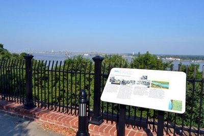
Near North Broadway Street near Jefferson Street, on the left when traveling north.
The Harper family mansion had a spectacular view of the river from the bluff. The construction of the railroad and related development made its land valuable for commerce, and the house and its garden were destroyed to build a large warehouse (no . . . — — Map (db m104673) HM
On Silver Street, 0.5 miles south of South Broadway Street, on the right when traveling south.
For most of the 1800s, the prime mover of commerce and passengers on the Mississippi River was the steamboat, which was invented by Robert Fulton in 1807. The combination of the steamboat, the cotton gin, and improved strains of cotton . . . — — Map (db m143122) HM
On Silver Street east of South Broadway Street, on the right when traveling east.
The Spanish built Silver Street about 1790 to connect the town to the riverfront below. In the 1800s, Natchez Under-the-Hill was a major port on the Mississippi River. Natchez exported and imported agricultural goods, with cotton being . . . — — Map (db m127108) HM
In the early 1700's, French colonists established a plantation called the "St. Catherine Concession" on this creek about two miles upstream from the Grand Village. The name was applied to the creek during the French colonial period in the Natchez . . . — — Map (db m106308) HM
On Natchez Trace Parkway (at milepost 8.7), 0.5 miles north of Blues Highway (U.S. 61), on the right when traveling north.
By 1810, most travelers along the Natchez Trace were Kaintucks
heading home.
Kaintucks – farmers and boatmen from the Ohio and
Mississippi river valleys – floated crops and other goods
to market in New Orleans or the bustling, edgy river . . . — — Map (db m244210) HM
On State Highway 1, 0.6 miles north of Avondale Road, on the left when traveling north. Reported missing.
After months of rainfall a swollen Mississippi River broke the levee at Mound Landing, some 2½ miles west, on April 21, 1927. The flood waters caused widespread destruction and loss of life in seven states. The breadth of the disaster focused . . . — — Map (db m154836) HM
On South Commerce Street at East Main Street, on the left when traveling south on South Commerce Street.
A fourth generation Choctaw countian, Ray Mabus grew up in Ackerman. In 1987 he was elected governor, the youngest in more than 150 years. Appointed Secretary of the Navy in 2009, he served until 2017, the longest tenure since WWI and the third . . . — — Map (db m140788) HM
Near Grand Gulf Road, 0.1 miles north of River Road.
In May 1862, cannoneers of Brookhaven Light Artillery, commanded by Captain James Hoskins, reached Grand Gulf. Hoskins had gunners emplace and mask four 6-pounders on bluffs behind the village. The task was to harass the Federals fleet commanded by . . . — — Map (db m103932) HM
Near Grand Gulf Road, 1.8 miles north of Frazier Road when traveling north.
On a ledge 40 feet above the Mississippi, the Confederates in March, 1863 , laid out Fort Cobun. Protected by a parapet nearly 40 feet thick were four big guns manned by Company A, 1st Louisiana Heavy Artillery. The guns of Fort Cobun under command . . . — — Map (db m105777) HM
On a shelf overlooking the charred ruins of Grand Gulf the Confederate engineers built Fort Wade. Guibor's and Wade's Missouri Batteries manned its four big guns. When Admiral David G. Farragut's squadron passed Grand Gulf on March 31, the guns of . . . — — Map (db m104093) HM
On Grand Gulf Road, 1.8 miles north of Frazier Road when traveling north.
War returned in March, 1863. Fearful that Major General Grant’s army might bypass Vicksburg, Lieutenant General J. C. Pemberton ordered Brigadier General John Bowen to move his troops to Grand Gulf. During the next several weeks, Bowen’s troops . . . — — Map (db m105776) HM
Near Grand Gulf Road, 1.8 miles north of Frazier Road when traveling north.
In 1863 Point of Rock jutted far above the swirling waters of the Mississippi. Before the Civil War there was a large house with extensive gardens on top of Point of Rock. Before Brigadier General John S. Bowen’s troops were ordered to Grand Gulf in . . . — — Map (db m105779) HM
Near Grand Gulf Road, 0.1 miles north of River Road.
In April, 1863 Major General Ulysses Grant decide to alter his Vicksburg strategy by moving his troops down the Mississippi River. On April 29, 1863 the Federals launched a determined assault on Grand Gulf. The Confederates made a rigorous reply to . . . — — Map (db m103933) HM
Near Grand Gulf Road, 1.8 miles north of Frazier Road when traveling north.
When General John S. Bowen’s troops moved to Grand Gulf in March 1863, they had to cope with the ocean-going warships of Admiral David G. Farragut. Knowing that these ships were made of wood, the Confederates determined to use hot shot against them. . . . — — Map (db m105781) HM
This XIII-inch Mortar
was probably used by the Union
in the fight for Vicksburg.
In the early 1900's it was seen
partially buried in the levee
on Davis Island. These mortars
were mounted on schooners
or box-like boats. . . . — — Map (db m104294) HM
Near Grand Gulf Road, 0.1 miles north of River Road.
Despite the estimated more than 2,500 heavy projectiles fired into the Confederate forts, there was little damage. The Confederates suffered three dead, including Colonel Wade, and eighteen wounded. Union losses totaled nineteen dead and fifty-seven . . . — — Map (db m103929) HM
This water wheel was originally built for Mr. and Mrs. J. L. Peacock of Mendenhall Ms., in 1948 and was donated by them to this park in 1971.
The wheel was built for the purpose of generating electricity by water power that operated a . . . — — Map (db m104095) HM
Near Grand Gulf Road, 1.8 miles north of Frazier Road when traveling north.
Grand Gulf was named for the large whirlpool or gulf formed by the current of the Mississippi River being diverted to the left by the rocky headland called Point of Rock. At the time of the Civil War, the Big Black discharged into the Mississippi at . . . — — Map (db m105782) HM
On Church Street (U.S. 61) south of Carroll Street, on the right when traveling south.
About 14 miles west at the mouth of Bayou Pierre is the old river port settled by Peter Bryan Bruin in 1788. It was visited by Aaron Burr in 1807. Grant landed there in Vicksburg Campaign of 1863. — — Map (db m103797) HM
On Old Port Gibson Road (Mississippi Route 462) at Old U.S. 61, on the left when traveling north on Old Port Gibson Road.
As Logan's division marched west toward Grand Gulf on May 3, 1863, M. M. Crocker's division moved toward Hankinson's Ferry. At Kennison Creek, one mile north, the road was blocked by two Confederate brigades. After a spirited skirmish, the . . . — — Map (db m103822) HM
On Old Port Gibson Road at Old U.S. 61, on the left when traveling north on Old Port Gibson Road.
After occupying Willow Springs on May 5. 1863,. Gen. U. S. Grant divided his force. The XVII Corps advanced on Hankinson s Ferry 5 miles north of here in two columns. Gen. M. M. Crocker's division driving up this road encountered a Confederate . . . — — Map (db m103849) HM
On Church Street (U.S. 61) at Walnut Street on Church Street.
Incorporated in 1811, Port Gibson was first settled by Samuel Gibson, who acquired property along Bayou Pierre from the Spanish in 1788. First known as Gibson's Landing. Port Gibson, selected as the Claiborne County seat in 1803, had the state's . . . — — Map (db m103803) HM
On Rodney Road west of Flower Street, on the right when traveling west.
About dark on May 1, 1863, Gen. W. E. Baldwin's Confederates retreated through Port Gibson. After crossing the suspension bridge over Little Bayou Pierre, the Confederates set it afire. On the morning of the 2d. the Union army entered the beautiful . . . — — Map (db m103808) HM
On Church Street (U.S. 61) south of Horton Drive, on the right when traveling north.
In April of 1861, rumors of Civil War became a reality at Charleston harbor when Fort Sumter was fired upon by Southern forces. Many leaders, both North and South, believed that a dash to capture the opposing side's capital city would bring a quick . . . — — Map (db m139494) HM WM
On U.S. 49 at State Route 1, on the right when traveling south on U.S. 49.
The Hernando de Soto expedition to explore and claim the Southeast for Spain crossed the Mississippi River on June 18, 1541, at a point in northwestern Mississippi between Sunflower Landing in Coahoma County to the south and Bass Landing in DeSoto . . . — — Map (db m107620) HM
Near River Street, 0.1 miles east of McLeod Avenue, on the right.
In November 1864, Union Brig. Gen. John
Davidson led an expedition from Baton
Rouge toward the Mobile & Ohio R.R. On
December 10, part of his force crossed
the Chickasawhay River and met two
Confederate cavalry regiments at McLeods
Mill. . . . — — Map (db m122344) HM
On Loop State Highway 333 at E J Henry Road, on the right when traveling north on State Highway 333.
Main defensive position on Yalobusha River line held by Gen. Pemberton in fall of 1862 to repel Gen. Grant, whose army of 25,000 was moving to attack Vicksburg. — — Map (db m89894) HM
On Scenic Mississippi Route 333, 0.1 miles north of Grenada Lake Visitor's Center, on the right when traveling north.
The Great Mississippi River Flood of 1927
affected an area of 27,000 square miles.
More than 130,000 homes were lost
and 700,000 people were displaced.
Congress took action, passing the Flood
Control Act of 1936. The U.S. Army
Corp of . . . — — Map (db m219775) HM
Near Discovery Circle, 0.5 miles west of State Highway 607, on the right when traveling west.
The SOC-R is designed as a high speed boat with ample weapons and equipment capacity. Its primary mission is insertion/extraction of SEALs into a low-to-medium threat environment in a riverine area. Secondary missions include providing fire . . . — — Map (db m107880) HM
Near Discovery Circle, 0.5 miles west of State Highway 604, on the right when traveling west.
NOAA completed the Tropical Atmosphere Ocean (TAO) array for the detection of El Niño and La Niña in the Pacific Ocean in 1994 after 10 years of development in which NOAA deployed 400 buoys on 83 separate cruises. Today, NOAA and the Japanese . . . — — Map (db m107882) HM
Near Discovery Circle, 0.5 miles west of State Highway 607, on the right when traveling west.
In 1995, NOAA began the development of the Deep-ocean Assessment and Detection of Tsunami (DART) system to provide better warnings for tsunami-prone communities. Until 2004, the U.S. operated 6 systems in the Pacific Ocean, however the network has . . . — — Map (db m107875) HM
On Bayview Avenue at Porter Avenue, on the left when traveling east on Bayview Avenue.
In 1880, self-made entrepreneurs Lazaro Lopez, F. William
Elmer, William Gorenflo, James Maycock, and William K. M.
Dukate formed a company that would launch Biloxi's seafood
industry. Inexperience did not thwart the partners. Dukate
traveled to . . . — — Map (db m102241) HM
On Beach Boulevard (U.S. 90) at Porter Avenue, on the right when traveling east on Beach Boulevard.
Front
On April 24, 1960, Gilbert R. Mason, Sr., M.D., led about 125 volunteers in a peaceful wade-in on segregated Biloxi Beach. Trained in non-violent passive resistance, they expected to be arrested. Instead they were attacked by a . . . — — Map (db m122359) HM
On Beach Boulevard (U.S. 90) at Porter Avenue on Beach Boulevard.
Since its construction in 1848, this cast iron lighthouse has been the landmark for which Biloxi-bound vessels sail. Tended by the Younghans family, father, mother and daughter, from late 1866 until 1929. — — Map (db m22778) HM
On U.S. 90 at Porter Avenue on U.S. 90. Reported missing.
Constructed in sections by the firm of Murray and Hazelhurst of Baltimore, Maryland, the Biloxi lighthouse arrived at this location aboard the brig General North and was erected in 1848. A cast iron sheath lined with locally made brick, the 48-foot . . . — — Map (db m95447) HM
On Beach Boulevard (U.S. 90) at Porter Avenue, on the right when traveling east on Beach Boulevard.
In 1848, the United States Lighthouse Service erected the South's first cast-iron lighthouse, in
Biloxi on a low sandy bluff overlooking the Mississippi Sound. The tower was fabricated by the
Murray and Hazelhurst Vulcan Works of Baltimore, . . . — — Map (db m102221) HM
Near Beach Boulevard (U.S. 90) 0.2 miles west of Oak Street.
The Biloxi schooner was first and foremost the work horse of the
seafood industry, but during the summer off-season it played a role
in maritime sport and recreation. As early as the 1830s, Biloxi-built
schooners were used for fishing and . . . — — Map (db m102248) HM
On Cadet Street at East 1st Street on Cadet Street.
Built here in 1934 as part of a U.S. Coast Guard base, the barracks was an E-shaped, Spanish Colonial Revival style building made of reinforced concrete. Arcaded porches lined the building's
wings and central pavilion, which had an octagonal . . . — — Map (db m102175) HM
On Howard Avenue east of Reynoir Street, on the left when traveling east.
The development of downtown Biloxi paralleled the economic
growth of the city. Biloxi's first economic boom occurred during the
antebellum period when daily stops by a steamboat packet between
New Orleans and Mobile turned the small village into . . . — — Map (db m102243) HM
This plaque is dedicated to bring awareness to the surge and high water levels from Hurricane Katrina and Hurricane Camille. Both storms brought about great devastation and loss of life to the Mississippi Gulf Coast. Hurricane Katrina made landfall . . . — — Map (db m102368) HM
On Cadet Street at East 1st Street, on the right when traveling north on Cadet Street.
Point Cadet encompasses the eastern tip of the Biloxi Peninsula. "Cadet" (pronounced Ka-day) is
the French word for junior or younger. In early records, it is shown as "Point-a-Cadda." Over time it became "Point Caddy." More recently, it has been . . . — — Map (db m102249) HM
During the early 19th Century, the Biloxi peninsula was sparsely populated
with a few French speaking families. The 1827 establishment of steamboat
service between New Orleans and Mobile, via Lake Pontchartrain, served
as a catalyst for the . . . — — Map (db m102223) HM
The 17th Century struggle among the French
Spanish, and English for supremacy on the
North American continent led the Bourbon King
of France, Louis XIV to sanction an expedition
from France to the Gulf of Mexico in 1698. The
command was given . . . — — Map (db m102218) HM
On Bay Shore Drive at Boney Avenue, on the left when traveling west on Bay Shore Drive.
Before roads and bridges, trading-posts were essential on the Bay Pierre and Celina Harvey built their home on this site, acquired from her father Joe Moran. In the 1830s, along with their children and a black female with child, they completed their . . . — — Map (db m122403) HM
On Central Avenue, 0.1 miles south of Bay Shore Drive, on the right when traveling south.
Long before the Europeans appeared on the Biloxi Back Bay
American Indians had trails that led to the water's edge, where
their canoes were beached for crossings. At the time Biloxi Bay
depths were incidental. That changed early in the . . . — — Map (db m122439) HM
On Race Track Road at Central Avenue, on the right when traveling west on Race Track Road.
By 1812, Spain ceded dominion of our Coast to the U.S., adding to
the Mississippi Territory. At the time most of north-shore Back Bay
Biloxi was settled by three related (Swiss-French) Ladnier families
and . . . — — Map (db m122431) HM
On Jones Park Drive, 0.2 miles east of 25th Avenue, on the right when traveling east.
The Louisiana Native Guards, composed largely of former slaves and free men of color from Louisiana, were organized by Union Maj. Gen. Benjamin Butler in 1862. On April 9, 1863, 180 men from companies B and G of the 2nd Regiment, landed at . . . — — Map (db m102161) HM
On Jones Park Drive, 0.2 miles east of 25th Avenue.
12 miles south of the mainland lies emerald waters and sugar white sand. Site of economic and military conquest by the Spanish in the 1500s and the French in 1699, the British in the 1700s, and the Union Army in 1861. Site of Civil War Fort . . . — — Map (db m102170) HM
Near Friendship Oak Circle west of Beach Park Place, on the right when traveling west.
Bear Point Bayou is fed by a natural spring
located north of the Louisville & Nashville
Railroad tracks near Wright Avenue. Bayou
waters flow southward through Long Beach into
the Mississippi Sound between Nicholson and
Douglas Avenues. Origin . . . — — Map (db m243119) HM
On Beach Boulevard East (U.S. 90) 0.1 miles west of East Azalea Drive, on the right when traveling west.
In 1788, Nicholas and Marianne Ladner became the first Europeans to settle in this area. Their log house, know as "The Chimneys", was used as a navigation point for boats traveling from Mobile to New Orleans. After Nicholas's death, the Spanish . . . — — Map (db m81001) HM
On Jeff Davis Avenue north of East 3rd Street, on the right when traveling north.
Hurricane Katrina
Considered one of the three most intense hurricanes to hit the United States. On Sunday, August 29, 2005, the Category 3 storm nearly devastated the City of Long Beach. Storm surge exceeded 28 feet. Six lives lost and 60 . . . — — Map (db m122391) HM
Near Ponce De Leon Boulevard south of Sandy Hook Drive, on the right when traveling south.
These grounds, from September 16, 1942 to March 21, 1950, were the site of the Pass Christian United States Merchant Marine Cadet Corps Basic School.
From here and the sister school at San Mateo, California, over 6000 undergraduates of the U.S. . . . — — Map (db m86086) HM
On Bolton-Raymond Road at East Madison Street (Old U.S. 80), on the left when traveling south on Bolton-Raymond Road.
Located 4.4 mi. S.W., is site of crucial battle in the Vicksburg defense, May 16, 1863. Grant, cutting off Johnston's relief, drove Pemberton from this hill across Big Black River. — — Map (db m89736) HM
On Old Port Gibson Road (Mississippi Route 462) at Cayuga Road, on the right when traveling north on Old Port Gibson Road.
Grant established his headquarters here on May 10, remaining two days. On May 11, Tuttle's and Steele's divisions of the XV Corps passed through Cayuga and the XIII Corps camps at Fivemile Creek to Auburn, three and a half miles northeast. Lacking . . . — — Map (db m103887) HM
Near Belmont Street (extended) west of Capitol Street when traveling west.
This spring and the surrounding land were
purchased from the United States
government in 1823 by Charles Lawson, a
surveyor in the federal land offices in
Jackson. In 1825, access to the spring
was given to Landy Lindsey, owner of the
nearby . . . — — Map (db m178439) HM
On Old U.S. 80, 0.5 miles west of Smith Station Road, on the right when traveling east. Reported missing.
After the defeat at Champion Hill, Confederate forces retreated to the Big Black River on the night of May 16, 1863. Here, Generals John Bowen and John Vaughn defended the east bank of the river and the bridge. On May 17, Federal forces under Gen. . . . — — Map (db m80679) HM
On Adams Lane near State Route 467, on the left when traveling south.
"Vicksburg is the key," said President Abraham
Lincoln. "The war can never be brought to a
close until that key is in our pocket."
The United States government had to control
the lower Mississippi River in order to move
agricultural . . . — — Map (db m110132) HM
On North Jackson Street south of State Route 12, on the left when traveling north.
W. 3 mi. Mineral springs created popular health spa prior to Civil War. Girls boarding school organized, 1854. In 1862, wounded from Shiloh treated here. Now Y. M.C.A. state camp. — — Map (db m140831) HM
On U.S. 49W north of Warren Street, on the right when traveling north.
On March 13, 1863, near this site, the NATCHEZ burned and sank in the Yazoo. Converted into a Confederate gunboat and armored with cotton bales, the vessel had been taken into the Yazoo to avoid capture. — — Map (db m121107) HM
On State Highway 465, 2 miles east of Section Road, on the left when traveling east.
The Steele's Bayou Expedition (March 14-27, 1863) was one of several Union efforts to bypass Confederate defenses at Snyder's Bluff by sending amphibious forces through the Delta's waterways. While the expedition ultimately failed in its objective, . . . — — Map (db m187815) HM
On West Main Street at South Cummings Street, on the left when traveling west on West Main Street.
In the early 1800s the area known as Fulton was first settled near the banks of the Tombigbee River. In 1836 after Itawamba County was formed, Kenneth Clarke, John D. Miller, and Robert A. Miller gave fifty acres of land to the Board of Police, and . . . — — Map (db m98609) HM
On East Main Street, 0.1 miles east of South Rose Street, on the right when traveling east.
Also known as the Cates-Gaither House, this one-story Greek Revival-style planters cottage was built in ca. 1859 by ship builder and merchant Pleasant Cates. The heavy framing includes original pegged joints. Named for the cedar trees on the . . . — — Map (db m96773) HM
On North Access Road at Campground Road, on the left when traveling north on North Access Road.
Front
The 2,006.5-mile Underground Railroad Bicycle Route (UGRR) was created by the nonprofit organization Adventure Cycling Association. From Mobile, Alabama, to Owen Sound, Ontario, the trail memorializes the Underground Railroad, a . . . — — Map (db m102972) HM
Near U.S. 90 at Beasley Road, on the right when traveling west.
This area was not always known as Gautier. The story of the city actually began in 1699. A French expedition, led by Pierre d'Iberville and accompanied by his younger brother, Jean-Baptiste Bienville, made landfall in Mobile, Alabama and explored . . . — — Map (db m122547) HM
Near Main Street (Mississippi Route 613) south of Robinson Avenue.
Only now are historians recognizing the extent Black soldiers and sailors, both slave and free, played in the American Civil War of 1861-1865. After the war ended some of these men made their home in Moss Point. In the area, now surrounding . . . — — Map (db m102287) HM
On Main Street (Mississippi Route 613) 0.1 miles north of Mc Innis Avenue, on the right when traveling north.
Dangerous missions World
War II approximately 8,700
mariners were killed at
sea, approximately 11,000
wounded 604 prisoners
60 died in prison camps
The Merchant Marines have
delivered the goods when and
where needed in . . . — — Map (db m102381) HM
On Iberville Drive east of Ames Avenue, on the right when traveling west.
Site probably used by Indians. Was most popular for medicinal properties from 1850s until 1920. Also known as 'Mineral Springs' and the best known nationally of Mississippi's many mineral spring resorts. — — Map (db m102206) HM
On Frederic Street at Live Oak Avenue, on the right when traveling south on Frederic Street.
The Captain H.H. Colle House is a center-hall style cottage. It dates from 1880 making it one of the oldest surviving structures from old Scranton (Pascagoula). Typical of home construction of this time period, the walls are horizontal wood boards . . . — — Map (db m122480) HM
On Beach Boulevard east of Oliver Street, on the right when traveling east.
Jackson County, being on the Confederate side during the American Civil War, suffered numerous incursions by Union forces. However, it was the one of April 9, 1863, which, although small by combat standards, had far-reaching import to Union . . . — — Map (db m102301) HM
On Beach Boulevard east of City Park Street, on the right when traveling east. Reported missing.
Pascagoula played a significant role in the national effort to win World War II. The city offered a seaport, a riverport, and a modern shipyard – the Ingalls Iron Works. As a result, the city's population grew from 6,000 to 35,000 by 1943. To handle . . . — — Map (db m242976) HM
Near Frederic Street, 0.1 miles west of Magnolia Street, on the right when traveling west.
The Pascagoula River basin is the largest and last unimpeded river system in the lower 48 states.
The basin is approximately 64 miles long and 84 miles wide with 16,045 miles of rivers and streams.
The Pascagoula River is the lifeblood . . . — — Map (db m122676) HM
On Cypress Avenue west of Pascagoula Street, on the right when traveling west.
The original Round Island lighthouse was built in 1833 on Round Island for $5,895 by Marshall Lincoln and David Henshaw. It was constructed using methods similar to those used on the East coast rather than methods suitable for the Gulf coast and the . . . — — Map (db m102291) HM
On Cypress Street west of Pascagoula Street, on the right when traveling west.
Round Island is located in the shallow Mississippi Sound only 3 miles offshore of the entrance to the Pascagoula River. By the early 19th Century increasing coastal commerce had made the need for a lighthouse critical. This first Round Island . . . — — Map (db m102363) HM
The Round Island Lighthouse was built on the barrier island of the same name located off the mouth of the Pascagoula River. Replacing an earlier structure built in the 1830's, the lighthouse was completed in 1859 for a cost of $7,130.97. The . . . — — Map (db m102386) HM
On Beach Boulevard east of Hague Street, on the right when traveling east.
During the American Civil War the Union forces' grand strategy, the Anaconda Plan, was to encircle and then strangle the Southern States into submission. Confederate response included the use of blockade runners that dashed through the naval . . . — — Map (db m122537) HM
Near Beach Boulevard, 0.3 miles west of Hague Street.
Jackson County is known for shipbuilding. Early settlers hand-crafted utility, fishing and local transportation boats to one-of-a-kind designs, but World War I saw explosive development of a modern industry. Dierks-Blodgett in Pascagoula, and . . . — — Map (db m102361) HM
On Front Street west of Watts Avenue when traveling west.
On July 18, the USS Grey Cloud and USS New London turned at Round Island and headed directly toward the large hotel at Pascagoula announcing their arrival by firing two shells over the hotel scattering the civilian population. Both . . . — — Map (db m122486) HM
On Beach Boulevard at Pascagoula Street, on the right when traveling east on Beach Boulevard.
Round Island is easily seen three miles south of the Pascagoula River entrance. In the summer of 1849 it was the site of an event which drew attendance by soldiers of fortune from all over the South and required intervention by the President of the . . . — — Map (db m122533) HM
On Bell Street west of Main Avenue (State Route 39), on the right when traveling west.
John C. Stennis (1901-1995) was born in the Kipling community in Kemper County and lived in DeKalb. As a circuit judge, he heard many cases in this courthouse. Elected to the U.S. Senate in 1947 and reelected six times, Stennis served as president . . . — — Map (db m140654) HM
On County Route 7, 1 mile north of Road 244, on the right when traveling south.
Following their defeat in the battle of Corinth, Confederate forces, now under Lt. Gen. John C. Pemberton, established a line of defense on the Tallahatchie River in November 1862. Union Gen. U.S. Grant, moving down the Mississippi Central Railroad, . . . — — Map (db m102633) HM
On East Jackson Avenue (Mississippi Route 314) west of North 9th Street, on the right when traveling west.
On December 2, 1862, as the Confederates
fell back to the Yalobusha River, Union
Gen. U.S. Grant moved his headquarters
from Waterford to Abbeville. On the 4th,
he moved to Oxford, while his advance
crossed the Yocona River. W.T. . . . — — Map (db m102879) HM
Lieutenant Read, a native Mississippian, is buried here. He was an 1860 graduate of Annapolis. With a crew of 17, he captured 22 Union ships in 21 days and struck terror across the eastern seaboard. This adventure has been called the most brilliant, . . . — — Map (db m111135) HM
Charles William “Savez” Read (1840-1890) was an officer in the pre-Civil War U.S. Navy. Joining the Confederate navy, Read was nicknamed the “Seawolf of the Confederacy” for his daring exploits.
After serving on the CSS . . . — — Map (db m111031) HM
On Brookhaven Street, on the right when traveling north.
Est. 1810 by Jos. Cooper, one blk. N. Primary reason St. Stephens Rd. took this route in 1812 from St. Stephens (Ala.) on the Tombigbee to Natchez. Site served as boat landing from 1826 through early 20th century. — — Map (db m50158) HM
On Main Street at South Church Street, on the right when traveling east on Main Street.
In Commemoration of
Hernando De Soto
and his men who spent the winter of
1540 — 1541
in North East Mississippi prior to his
discovery of the Mississippi River — — Map (db m102786) HM
On South Spring Street south of Elliott Street, on the left when traveling south.
The Battle of King's Creek
The campaign to take Vicksburg and control of the Mississippi River
had begun. On May 5, 1863, mounted infantry and cavalry units of the
Federal Ninth Illinois, Tenth Missouri and Seventh Kansas, under . . . — — Map (db m102851) HM
On East Main Street (U.S. 278) 0.1 miles east of East Elizabeth Street, on the right when traveling east.
The Tupelo Swamp
Military strategists agree that when two forces of equal size oppose one another, the defending force has the advantage. Tupelo's geography emphasized that point during the war. Surrounded north, east and south by . . . — — Map (db m102841) HM
On West Church Street at Dewey Street, on the left when traveling west on West Church Street.
To Commemorate the Enterprise and Initiative
of
Charles Edward Wright
Who in May 1895, 901 feet east of this spot
sank the first overflowing well in the
Mississippi Delta and gave to its people the
blessing of artesian water, . . . — — Map (db m77439) HM
Near U.S. 49E at Levee Road, on the right when traveling west. Reported missing.
Here is site of fort at which Grant's gunboats bound for Vicksburg, early in 1863, were halted by fort batteries and by the sunken hulk of the "Star of the West" in channel. — — Map (db m132320) HM
On U.S. 82 at Levee Road, on the right when traveling west on U.S. 82.
In the 1863 Campaign against Vicksburg, General Grant tried several approaches, one being to send troops on transports down the Tallahatchie and Yazoo Rivers. He cut the Mississippi River levee in February which flooded the several bayous between . . . — — Map (db m77329) HM
On Fulton Street at West Market Street, on the left when traveling north on Fulton Street.
Front
CSA
1861-1865
Leflore County's tribute
to her sons and daughters
of the Southern Confederacy.
Erected under the auspices
of the Varina Jefferson Davis
Chapter United Daughters
of the Confederacy.
Oct. 9, . . . — — Map (db m77355) WM
On Strong Avenue at Mary Street, on the right when traveling east on Strong Avenue.
Burial spot of veterans of four wars. Among 40 Confederates was Lt. Azro A. Stoddard, who carried out orders to scuttle “Star of the West,“ thus preventing federal use of Yazoo River route to Vicksburg. — — Map (db m77188) HM
On Fulton Street at Ramcat Alley, on the left when traveling north on Fulton Street.
N.E. 2 mi., at junction of Tallahatchie and Yalobusha Rivers is site of extinct town founded in 1830's by Greenwood Leflore. Achieved great prosperity in era before Civil War. — — Map (db m77181) HM
On 2nd Avenue North at N. 6th Street on 2nd Avenue North.
Founded, 1839, through efforts of Talbert Fanning and David Lipscomb. Present structure, erected 1849-50, housed refugee State Senate in Civil War. Here Tennessee-Tombigbee Waterways Agreement was signed in 1958. — — Map (db m8555) HM
Near Natchez Trace Parkway (at milepost 122), 1.1 miles south of Ratliff Ferry Road, on the left when traveling south.
In 1698 the French explorer, Pierre Le Moyne, Sieur d'Iberville, sailed into the mouth of this river and found pearls. He named it "River of Pearls."
The Natchez Trace, a hundred years later, avoided the marshy lowlands by following the ridge . . . — — Map (db m86031) HM
On Mississippi Route 7, 1.5 miles south of Waterford Mountain Road, on the right when traveling south. Reported missing.
In November 1862, Col. Albert Lee's cavalry and Gen. Charles Hamilton's infantry division led the Union advance down the Mississippi Central R.R. Here, at Lumpkin's Mill, Lee's men met Col. William H. Jackson's Confederate cavalry. After a spirited . . . — — Map (db m102632) HM
205 entries matched your criteria. The first 100 are listed above. Next 100 ⊳