On E. Main Street at S. 3rd Avenue, on the right when traveling east on E. Main Street.
This building was designed by U.S. Government architect James Knox Taylor. It is a textbook example of Georgian Revival style architecture with its massive rectangular size, brick façade, cornice, arched windows, modillions under the eaves, and . . . — — Map (db m132571) HM
Near 1st Avenue south of East Main Street, on the right when traveling south.
Three stone houses were built during the 1920's by Thaddeus P. Giddings (1969-1954). Giddings was the Supervisor of Music for the Minneapolis Schools and founder of the National Music Camp in Interlachen, Michigan. The stone houses were part . . . — — Map (db m70825) HM
On Jefferson Street west of 3rd Avenue, on the right when traveling east.
This house was the home of three generations of the Ticknor Family, who greatly contributed to the development of Anoka. The architecture of the house incorporates design features of Gothic Revival (1867, design of original house) and the Queen Anne . . . — — Map (db m181514) HM
On Lake Avenue just north of Frazee Street, on the right when traveling north.
This courthouse constructed by Becker County in cooperation with the Works Progress Administration of the Federal Works Agency S. L. Stolte • State Administrator Harry Phinney • District Manager W. R. Koester • District Engineer Albert . . . — — Map (db m209093) HM
On Minnesota Avenue Southwest just south of 1st Street West, on the left when traveling south.
June 1911 Bemidji Commercial Club entertains Louis Hill, Governor Eberhart, and others at Markham Hotel for dinner and tours them around the Bemidji area hoping Hill will commission a new Great Northern Depot in Bemidji. April 24, 1912 . . . — — Map (db m235292) HM
On North Minnesota Street south of 3rd North Street, on the right when traveling south.
This three-story building is a fine example of Queen Anne commercial architecture. The original southern section was erected in 1892 for the Buenger Furniture Store, while the corner building was constructed in 1902.
Louis Buenger Sr. . . . — — Map (db m68117) HM
On North State Street at Center Street on North State Street.
This home was built by John Lind in 1887 and was a significant cultural, social and political center built on a prominence above early New Ulm. Swedish born Lind came to America and Minnesota in 1867 at age thirteen. While very young he was a . . . — — Map (db m65399) HM
On North Minnesota Street south of 3rd North Street, on the left when traveling south.
The Kiesling House is one of the three downtown buildings in New Ulm to survive the Dakota War of 1862. Frederick W. Kiesling, blacksmith and ferrier, had built the modest frame house ($125) the year before the outbreak of the war. In August of . . . — — Map (db m65497) HM
On 4th North Street west of North Minnesota Street.
Schonlau Park, named in honor of Theodore H. and Clara K. Schonlau, is the setting for the City of New Ulm’s unique Glockenspiel. Local contributors were joined by donors from three foreign countries, 31 States, and 51 other Minnesota cities, in . . . — — Map (db m65492) HM
On Center Street east of South Broadway Street, on the right when traveling east.
In 1874, shortly after George Kuhlman arrived in New Ulm, he constructed a home on this site. The same year, he was appointed as Brown County’s Attorney to fill a one-year opening left by his predecessors death. In addition to his legal vocation, . . . — — Map (db m153851) HM
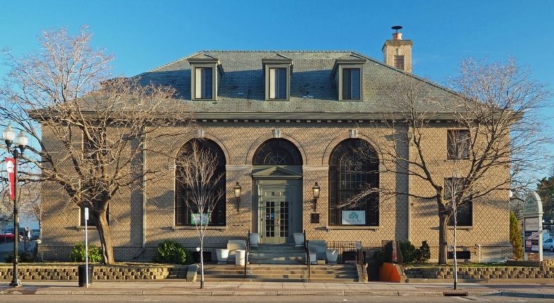
On Center Street at Broadway Street (Minnesota Highway 15 / 68) on Center Street.
The federal government erected the post office building in 1910, designed by James Knox Taylor, the supervising architect of the United States Treasury. Although the city's postal service began in 1856, it had been located in rented space . . . — — Map (db m74074) HM
On Broadway Street North at 4th Street East, on the right when traveling north on Broadway Street North.
Carver Historic District
has been placed on the
National Register
of Historic Places
by the United States
Department of the Interior
Funk Hardware Store
ca. 1880 — — Map (db m79278) HM
On Broadway Street at Main Street West (County Highway 40), on the right when traveling south on Broadway Street.
Carver Historic District
has been placed on the
National Register
of Historic Places
by the United States
Department of the Interior
Stephen Kult Clothing Store
1871 — — Map (db m79125) HM
On West 4th Street west of North Chestnut Street (Minnesota Highway 41), on the right when traveling west.
This property
has been placed on the
National Register
of Historic Places
by the United States
Department of the Interior
Brinkhaus Livery Stable
1890 — — Map (db m59555) HM
Near Grimm Road west of Victoria Drive (County Route 11), on the right when traveling west.
The Brick Farmhouse
The brick farmhouse before you was built by the Grimm family sometime around 1875. It replaced a small log cabin where the family had lived since they first acquired the property in 1857. More than just a new home, this . . . — — Map (db m212381) HM
On Lewis Avenue North just north of Territorial Street West, on the right when traveling north.
Minnie Christina Peterson Upon her father's death in 1914, Minnie became the sole proprietor of the Watertown General Merchandise Store. It's been said that Minnie was "way ahead of her time for a business woman." She passed away in a tragic . . . — — Map (db m213045) HM
On St Croix Trail (State Highway 95) 0.3 miles south of Mulberry Street (County Highway 34), on the left when traveling south.
So read the local paper in 1904 as engineers surveyed the Saint Croix River in search of a suitable place to build a hydroelectric project. The falls had long fueled the local lumbering and milling industries, but the Minneapolis General Electric . . . — — Map (db m120099) HM
On 8th Street (U.S. 75), on the right when traveling north.
Born in Maine in 1842, Solomon G. Comstock worked on the family farm until he came of age and then followed the pioneers west. After reading law in Bangor, he studied at the University of Michigan, then went to Omaha and Minneapolis. Finally, in . . . — — Map (db m207124) HM
Near Park Drive (County Road 38) just north of Itasca Township Road 4, on the left when traveling north.
This replica of the original Wegmann Store was built in 1977 as part of an ongoing summer crafts program to demonstrate log cabin construction. The replica was built by craftsperson Christopher Alpine from Lengby, Minnesota. While the original . . . — — Map (db m155674) HM
You are standing near the former site of the Judge's Cabin built approximately 1934.
"American Plan" was a popular cabin rental option from the 1920s-1970s. American Plan cabins were furnished with beds, chairs, dressers, and a wash . . . — — Map (db m235864) HM
On 10th Street west of 3rd Avenue, on the left when traveling west.
This property has been placed on the National Register of Historic Places by the United States Department of the Interior Cottonwood County Courthouse 1904 — — Map (db m157788) HM
Near County Road 11, 0.3 miles east of State Highway 371, on the left when traveling east.
Welcome to Paul M. Thiede Fire Tower Park. The main feature of the park is the historic Pequot Fire Lookout Tower. The 100-foot tower, which is listed on the National Register of Historic Places, sits atop a tall hill, providing up to a 20-mile . . . — — Map (db m237392) HM
Near County Road 11, 0.3 miles east of State Highway 371, on the left when traveling east.
The hillcrest where you are standing is 1,378 feet above sea level, 70 feet higher than County Road 11 at the entrance to the park. Add another 100 feet to the floor of the tower cab, and you get a commanding view of the area. This site was . . . — — Map (db m237500) HM
Near County Road 11, 0.3 miles east of State Highway 371, on the left when traveling east.
Art Savage came to Pequot Lakes in 1939 to serve as a Forest Ranger for the Minnesota Department of Conservation, where a significant part of his duties included staffing the fire tower. Art and Beatrice Savage lived in the Spotter's Cabin from . . . — — Map (db m237560) HM
Near County Road 11, 0.3 miles east of State Highway 371, on the left when traveling east.
A 10-foot by 16-foot wooden building was built here in 1928, to house firefighting equipment. Forest Ranger Art Savage noted that in 1939 his firefighting equipment included 6 pump tanks, 6 shovels and 2 axes. He also recalled having to use his own . . . — — Map (db m237546) HM
On West 2nd Street at Vermillion Street, on the left when traveling west on West 2nd Street.
What does a house say about its occupants?
The West 2nd Street Residential Historic District, just to the west between Eddy and Forest streets, vividly shows the diversity of house styles built between 1857 and 1890. A short walk to the . . . — — Map (db m198547) HM
On 2nd Street East just east of Sibley Street, on the left when traveling east.
was especially built for the retail, wholesale hardware business Henry Hudson Pringle established at Hastings in 1856. Originally, this building was a three-story stone structure with a rounded roof having two front entrances: one on Second Street, . . . — — Map (db m211232) HM
On D Street north of Great River Road, on the left when traveling west.
Faribault House
Built by Jean Baptiste Faribault pioneer fur trader.
Presented to the Sibley House Association Minnesota D.A.R. by the State of Minnesota
January 5th 1935.
Dedicated May 5th 1937.
Restored by the Federal Government . . . — — Map (db m244960) HM
On Sibley Memorial Highway (State Highway 13) south of D Street.
The history of Minnesota is replete with stories of boomtowns becoming ghost towns. Sometimes their demise was caused by national or historical shifts in markets, such as the fading of the fur trade or the bottoming out of the wheat market. Other . . . — — Map (db m199637) HM
Near Sibley Memorial Highway west of Minnesota Route 13, on the left when traveling north.
Until the late 1990s, people drove their cars into the overlook. They followed a curving route and went through an opening in the northern wall.
Works Progress Administration (WPA) workers quarried local Platteville limestone . . . — — Map (db m228924) HM
On 2nd Street Northwest at 4th Avenue Northwest, on the left when traveling west on 2nd Street Northwest.
Recognized as a local landmark since its construction, the Kasson Water Tower looks over the community. In 1895, 25 residents petitioned the Village of Kasson to erect a waterworks system inside the village limits. In June of that year, the council . . . — — Map (db m235300) HM
On South Broadway Avenue (U.S. 65) south of College Street, on the right when traveling north.
1856 • Court Square
Dedicated to Freeborn County by Ruble family
1886 • Richardson Romanesque Courthouse
Designed by architect C.A. Dunham of Burlington, IA
1888 • Courthouse construction completed
Alex McNeil Contractor . . . — — Map (db m127217) HM
On South Broadway Avenue (U.S. 65) at William Street, on the right when traveling north on South Broadway Avenue.
Firemen's Hall and Masonic Lodge
147 North Broadway
Built in 1909-1910, the upper floor houses the Masonic Lodge. The rest of the building served at one time as the “Idle Hour Theatre” and was later used by various area youth . . . — — Map (db m127861) HM
On West Avenue, 0.1 miles north of West 2nd Street, on the right when traveling north.
A vital river crossing for 63 years
1869
The new bridge was designed to be "high enough and strong enough", because spring floods had destroyed earlier river crossings.
1871
A roof and sidewalls were added to protect the . . . — — Map (db m203016) HM
Listed on the National Register of Historic Places.
Restoration funded through a $270,000 grant appropriated by the Legislative Commission on Minnesota Resources.
A project of the Minnesota State Historical Society and the City of . . . — — Map (db m117721) HM
Welcome to the 19th century dwelling of Gideon and Agnes Hopkins Pond, missionaries to the Dakota Indians, farmers, and ministers to the community of Bloomington, Minnesota, during the mid- to late-1800s.
Following a move from the Lake . . . — — Map (db m117722) HM
Near James Deane Parkway, on the left when traveling north.
The house on the hill...
On the hill before you stands the first frame house built within the original confines of Maple Grove Township. It was constructed in 1854 (four years before Minnesota became a state) by Pierre Bottineau, one of . . . — — Map (db m197973) HM
On Hennepin Avenue at Lagoon Avenue, on the right when traveling north on Hennepin Avenue.
Originally built in 1913 as the Lagoon Theater, this 1,500-seat venue was considered to be among the finest movie houses outside downtown. In 1929, the theater was rechristened "The Uptown"; its re-opening publicity declared, "New Uptown . . . — — Map (db m238169) HM
On Hennepin Avenue north of Lagoon Avenue, on the right when traveling south.
When the Walker Branch of the Minneapolis Public Library opened in 1911, the Hennepin and Lake area was still sparsely developed. T.B. Walker, founder and longtime president of the Library Board, donated the property near the . . . — — Map (db m234838) HM
On Hennepin Avenue north of W. 31st Street, on the right when traveling north.
When the Granada Theater opened in 1928, it was touted as the "most elaborate theater ever constructed outside the loop district in Minneapolis." It was one of the first movie theaters designed by local architects Jack Liebenberg . . . — — Map (db m242607) HM
On W. Lake Street at Lyndale Avenue S., on the right when traveling east on W. Lake Street.
The intersection of Lake Street and Lyndale Avenue emerged as one of Minneapolis' earliest commercial areas. A cluster of stores stood at the intersection as early as 1885. Two of its most significant buildings were erected at this . . . — — Map (db m240050) HM
On Kenwood Parkway at West Lake of the Isles Parkway, in the median on Kenwood Parkway.
Given to the people of Minneapolis in 1891 by F.H. Peavey as a drinking fountain for horses. This monument was rededicated as a memorial to the horses of the 151st Field Artillery Minnesota National Guard killed in action in the First World War. — — Map (db m76192) WM
On Hennepin Avenue, 0.1 miles South 5th Street, on the right when traveling east.
In 1887, the Lumber Exchange Building was constructed to house the offices of lumber distributors. The lumber industry was expanding, and a building was needed to house those engaged in the business. The Lumber Exchange Building was originally . . . — — Map (db m245464) HM
Near Portland Avenue near West River Parkway, on the left when traveling north.
The historical, weather-worn bricks of today's Whitney have a story to tell. Since the late 1800s, these bricks have shaped the Minneapolis riverfront and witnessed its transformation. Once covered with the white dust of flour, these walls now . . . — — Map (db m231337) HM
On Minnehaha Avenue, on the right when traveling north.
Do you know how many times the Stevens House has been moved?
For 134 years, this small wood structure has been moved four times. The third move, which brought the house to Minnehaha Park, is heralded as the first act of historic . . . — — Map (db m243432) HM
On Grant Street / 2nd Avenue south of 12th Street, on the right when traveling west.
The Eagles installed on the Convention Center Plaza are artifacts removed from the 1927 era Auditorium which was located on the nearby site now occupied by the new Minneapolis Convention Center. The old Auditorium was bounded by Grant Street on . . . — — Map (db m91399) HM
On Grant Street west of Nicollet Mall, on the right when traveling west.
Loring Park has 14 historically designated buildings as well as the Harmon Place Historic Auto District. Some of the designated buildings include the Minneapolis Woman's Club, the Basilica of St. Mary, the Loring Theater, the Wesley Methodist . . . — — Map (db m91408) HM
On Broadway Street NE east of New Brighton Boulevard, on the left when traveling east.
Northeast Homes Have Distinct Differences
Northeast Minneapolis housing is distinctly different from that in other parts of the city. The upper-middle class and business owners built the older houses in much of Minneapolis. But in old St. . . . — — Map (db m232206) HM
On Cedar Avenue north of E. Lake Street, on the right when traveling north.
Martin and Elizabeth Layman were typical of the transplanted Easterners who settled in Minnesota in the mid-1800s. They arrived in Minnesota in 1853, where they eventually settled with their children on a farm on the southern edge of the . . . — — Map (db m245596) HM
On The Midtown Greenway east of South 5th Avenue, on the left when traveling east.
New Goods for a New Era
The pace of life in Minneapolis quickened in the decade between 1910 and 1920. The population expanded from 301,498 to 3...82, and the ... factories, railroads, and ... nks m... it ... with a trade ... n stro... ng .. . . . — — Map (db m240652) HM
On Park Avenue at E. Lake Street, on the right when traveling north on Park Avenue.
Originally developed to be a stylish boulevard lined with architect-designed homes situated on large lots with generous setbacks, Park Avenue once ranked as Minneapolis' most prestigious residential street.
Throughout the late . . . — — Map (db m233946) HM
On Stevens Avenue at East 22nd Street, on the right when traveling north on Stevens Avenue.
Did you know that 'Washburn Fair Oaks' was originally the name of the mansion that once stood here?
One of the largest homes in Minneapolis in the 1880s, it was built by William D. Washburn. His brother Cadwallader Washburn founded the . . . — — Map (db m156784) HM
On Southeast Main Street, 0.1 miles west of Southeast 3rd Avenue, on the left when traveling west.
The village of St. Anthony was platted in 1849, and by 1855 a number of frame buildings stood along Main Street. In that year brothers Moses and Rufus Upton constructed a fine business block from locally made brick and opened a store on the ground . . . — — Map (db m155483) HM
Near Southeast Main Street south of Merriam Street.
Several structures have dominated the crest of the hill above this spot. The first was a luxury hotel named the Winslow House, built in 1857 by James M. Winslow while St. Anthony was still a favorite resort and health spa. Its style of . . . — — Map (db m50208) HM
By the 1960s, generations of heavy use had taken a toll on the houses. Fewer families remained. Many homes became rental properties for students and artists. As front porches were enclosed and deteriorated brick was covered with stucco, the area's . . . — — Map (db m151471) HM
The Knoll (1886–1907)
The oldest University of Minnesota buildings are on the north end of campus. They were built facing an open area with a knoll. This area stretched from the Pillsbury Gate, on the corner of University Avenue and East . . . — — Map (db m156840) HM
A Gathering Place
In a nation still gripped by the Depression, the lavish new union on the University of Minnesota campus attracted national attention. The building was much needed, but a long time in coming. Although there had been . . . — — Map (db m156834) HM
1 View of the first Washington Avenue Bridge, with streetcars in use, 1940
2 O. Meredith Wilson breaks ground for the West Bank campus
3 Construction under way on the West Bank
4 Crossing the river: the . . . — — Map (db m232012) HM
Near Minnesota Route 38 north of Little Ranier Road, on the right when traveling north.
The Civilian Conservation Corp [sic] was started on April 5th, 1933 by President Roosevelt. Also known as the "Tree Army" they would be mainly made up of unemployed men from rural settings during the Great Depression. The CCC was operated under the . . . — — Map (db m225693) HM
On Porto Rico Street Northeast north of High Avenue Northeast, on the right when traveling north.
The Sperry House was built in 1893 when this site was A. H. Sperry's farm. Featuring exterior brick, gables, wood molding, stained glass windows and carved interior oak woodwork, it was proclaimed by the Willmar Argus as "one of the finest . . . — — Map (db m231808) HM
On Old Ottawa Road (Bryant Street) south of Liberty Street, on the right when traveling south.
Built on a shelf of oneota dolomite limestone, Ottawa is home to six little known treasures from the past. Platted in 1853, the once thriving village has left behind a collection of limestone structures that have stood the test of time, all built . . . — — Map (db m212838) HM
On Lake Avenue north of West 2nd Street, on the right when traveling south.
Chubb House
Built in 1867 by Dr. Orville P. Chubb, this is the oldest brick house still standing in Fairmont. The bricks were "burnt" of clay from Buffalo Lake in Martin County. It is a tribute to the strength, beauty and vitality of our . . . — — Map (db m237402) HM
Near Main Street North (State Highway 15) at 2nd ave. nw, on the right when traveling north.
Corner of Washington Avenue
and Franklin Street
The structure served as a multipurpose facility which housed the municipal offices, police and fire department, a courtroom, an auditorium complete with stage and the first elegant ladies . . . — — Map (db m195912) HM
On North Marshall Avenue north of East 3rd Street, on the right when traveling north.
The Grand Army of the Republic was an organization established in 1866 by Union veterans of the Civil War to preserve friendships, honor fallen comrades, and aid widows and the handicapped. It was wielded great political influence in the years . . . — — Map (db m70427) HM
On East 3rd Street at North Sibley Avenue (U.S. 12) on East 3rd Street.
Grand Army of the Republic Hall
This brick fortress style building across from Central Park was built in 1885 by Civil War Union soldiers to help promote veterans causes and to provide assistance to veterans and their families.
The . . . — — Map (db m70793) HM
On Oodena Drive at U.S. 169, on the right when traveling east on Oodena Drive.
After living in the cramped quarters of their rental cabins for more than twenty years, Harry and Jeannette Ayer built this house in 1941.
During the heyday of the Trading Post, the Ayers lived simply during the summer. Each winter they . . . — — Map (db m237719) HM
On 1st Street NW at 1st Avenue NW, on the right when traveling north on 1st Street NW.
Cass Gilbert Depot
has been placed on the
National Register
of Historic Places
by the United States
Department of the Interior
Built 1899 — — Map (db m78231) HM
On 1st Street SE south of 5th Avenue SE, on the right when traveling south.
The Burton/Rosenmeier House is significant architecturally as the outstanding example of the Classical Revival style in Little Falls and for its associations with its first two inhabitants: The Barney Burton family and later the Rosenmeier . . . — — Map (db m78472) HM
Holding Up The H2O
The water tower was completed in 1939 by Works Progress Administration (WPA) workers. It stands three stories high.
Water towers use gravity to create pressure that moves water through supply pipes. Each foot of height . . . — — Map (db m78380) HM
Permanent white settlement began in the area in 1856 when Elk City was established. A map of Elk City shows a stone quarry on a river bank where a buried mass of bedrock created a rise in a trail.
The bedrock exposed at Little Elk had little . . . — — Map (db m224168) HM
From the late 1800s to 1904 this land was owned by retired Indian Agent Major Ashley Morrill.
He had several roads built on the property. One took Morrill from his lavish three-story mansion near the road bridge over Little Elk River to a . . . — — Map (db m225964) HM
On Grand Avenue West at Main Street, on the right when traveling west on Grand Avenue West.
This building, designed by architects William G. Purcell and George G. Elmslie stands as a historic symbol of the Prairie School style of architecture.
Built in 1910, the building captures many of the artistic and structural design . . . — — Map (db m145221) HM
On Skaro Street at North Washington Avenue on Skaro Street.
In 1871, Eugene St. Julien Cox, a man of eccentric tastes and "great vigor of mind" built this picturesque neo-Gothic Italianate house noted for its towered cupola, small balconies, and carved eaves.
Cox began his law career in 1857 and . . . — — Map (db m65464) HM
On 13th Street just north of 4th Avenue, on the right when traveling north.
Dayton House (marker south side) • • • Worthington banker and real estate developer George Draper Dayton commissioned this home for his family of six. The Historic Dayton House was constructed over four months during the summer of 1890 for a . . . — — Map (db m157789) HM
On 2nd Street SW at 4th Avenue SW, on the right when traveling west on 2nd Street SW.
Built in 1862, during the Civil War, eight years after the founding of
Rochester (1854), the primitive "chapel" measured only 27 by 55 feet.
It was built on the original plat of bricks made in Rochester. Two lots
were given by George Head, . . . — — Map (db m147342) HM
On 4th Street SW west of 1st Avenue SW, on the right when traveling east.
Conley Maass Downs Bldg. built 1900 has been placed on the National Register of Historic Places by the United States Department of the Interior — — Map (db m146895) HM
Near West Circle Drive (County Road 22 SW) 1.8 miles east of U.S. 52, on the right when traveling south.
Hadley Valley School was built in Olmsted County in approximately 1885 and is preserved here as a symbol of the pioneer's desire that his children have an education.
Moving of the school has been made possible by Mr. and Mrs. G. M. Lowry in . . . — — Map (db m179019) HM
On Mayowood Road Southwest, 0.6 miles west of Mayowood Hills Drive Southwest, on the left when traveling west.
A great love of nature led Dr. Charles Horace Mayo, co-founder of the Mayo Clinic, and his wife Edith (Graham) Mayo to purchase a small red brick house and 340 acres in 1907. Their growing family and desire to preserve the natural beauty of the . . . — — Map (db m196339) HM