8712 entries match your criteria. Entries 101 through 200 are listed.⊲ Previous 100 — Next 100 ⊳
Parks & Recreational Areas Topic
By Syd Whittle, January 1, 2016
1912 Parker Carousel Marker and Safety Instructions
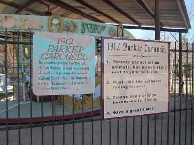
| 101 ► Arizona, Maricopa County, Queen Creek — 1912 Parker Carousel — |
| Near South Rittenhouse Road, on the right when traveling west. | |||
| 102 ► Arizona, Maricopa County, Scottsdale, The Promenade — Frank Lloyd Wright and Arizona — |
| 103 ► Arizona, Mohave County, Fredonia — A New National Monument — Pipe Spring National Monument — |
| Near North Pipe Spring Road, 0.3 miles north of Arizona Route 389, on the left when traveling north. | |||
| 104 ► Arizona, Mohave County, Fredonia — Stephen Tyng Mather — July 4, 1867 — Jan. 22, 1930 — |
| Near North Pipe Spring Road, 0.3 miles north of Arizona Route 389, on the left when traveling north. | |||
| 105 ► Arizona, Mohave County, Kaibab — 5 — Pipe Springs National Monument — |
| Near North Pipe Springs Road. | |||
| 106 ► Arizona, Mohave County, Kingman — Charles Metcalfe Park — |
| Near Grandview Avenue near West Beale Street (Business Interstate 40). | |||
| 107 ► Arizona, Mohave County, Kingman — Locomotive Park — Engine 3759 / Caboose No. 999520 — |
| On West Andy Devine Avenue (Old U.S. 66) at North 1st Street, on the right when traveling west on West Andy Devine Avenue. | |||
| 108 ► Arizona, Mohave County, Willow Beach — Explore Lake Mead — National Recreation Area — Lake Mead National Recreation Area |
| On U.S. 93, 3 miles north of Willow Beach Road, on the right when traveling south. Reported damaged. | |||
| 109 ► Arizona, Navajo County, Holbrook — Giant Logs — |
| Near Petrified Forest Road, 2.3 miles east of U.S. 180. | |||
| 110 ► Arizona, Navajo County, Holbrook — Pioneers of Paleontology — |
| Near Petrified Forest Road, on the left when traveling north. | |||
| 111 ► Arizona, Navajo County, Holbrook — Stephen Tyng Mather — July. 4, 1867 - Jan.22, 1930 — |
| On Petrified Forest Road, on the left when traveling north. | |||
| 112 ► Arizona, Navajo County, Shonto — Welcome to the Historic Contact Station — Navajo National Monument — National Park Service, U.S. Department of the Interior — |
| Near County Highway 221 at Tsegi Canyon Road when traveling east. | |||
| 113 ► Arizona, Navajo County, Winslow — Central Plaza — Homol'ovi II Archaeological Site — |
| Near Homolovi State Park Entrance Road, 5.4 miles north of Arizona Route 87. | |||
| 114 ► Arizona, Navajo County, Winslow — East Plaza — Homol'ovi II Archaeological Site — |
| Near Homolovi State Park Entrance Road, 5.4 miles north of Arizona Route 87. | |||
| 115 ► Arizona, Navajo County, Winslow — Homol'ovi II — Homol'ovi II Archaeological Site — |
| Near Homolovi State Park Entrance Road, 5.4 miles north of Arizona Route 87. | |||
| 116 ► Arizona, Navajo County, Winslow — Illegal Digging — Homol'ovi II Archaeological Site — |
| Near Homolovi State Park Entrance Road, 5.4 miles north of Arizona Route 87. | |||
| 117 ► Arizona, Navajo County, Winslow — Kiva - Underground House — Homol'ovi II Archaeological Site — |
| Near Homolovi State Park Entrance Road, 5.4 miles north of Arizona Route 87. | |||
| 118 ► Arizona, Navajo County, Winslow — Nuvatukya'ovi — Homol'ovi II Archaeological Site — |
| Near Homolovi State Park Entrance Road, 5.4 miles north of Arizona Route 87. | |||
| 119 ► Arizona, Navajo County, Winslow — Paayu — Homol'ovi II Archaeological Site — |
| Near Homolovi State Park Entrance Road, 5.4 miles north of Arizona Route 87. | |||
| 120 ► Arizona, Navajo County, Winslow — Standin’ on the Corner Park, Winslow, Arizona — Route 66 Roadside Attraction — |
| On North Kinsley Avenue at West 2nd Street (Business Interstate 40), on the right when traveling south on North Kinsley Avenue. | |||
| 121 ► Arizona, Navajo County, Winslow — Typical Room — Homol'ovi II Archaeological Site — |
| Near Homolovi State Park Entrance Road, 5.4 miles north of Arizona Route 87. | |||
| 122 ► Arizona, Navajo County, Winslow — Vandalized Kiva — Homol'ovi II Archaeological Site — |
| Near Homolovi State Park Entrance Road, 5.5 miles north of Arizona Route 87. | |||
| 123 ► Arizona, Pinal County, Coolidge — Stephen Tyng Mather — July 4, 1867 — Jan. 22, 1930 — |
| Near West Ruins Drive. | |||
| 124 ► Arizona, Pinal County, Superior — What is the Story Behind the Picketpost House? — ... a wealthy man built a house and planted a vision — |
| Near U.S. 60 at milepost 223 at Boyce Thompson Road, on the right when traveling east. | |||
| 125 ► Arizona, Yavapai County, Jerome — Laura Williams Memorial Park — |
| On Main Street (Arizona Route 89A), on the right when traveling east. | |||
| 126 ► Arizona, Yavapai County, Lake Montezuma — Historic Bell Trail — |
| Near Nf618A east of Forest Road 618. | |||
| 127 ► Arizona, Yavapai County, Peach Springs — Grand Canyon Caverns, Peach Springs, Arizona — Route 66 Roadside Attraction — |
| On Grand Canyon Caverns Road, on the right when traveling west. | |||
| 128 ► Arizona, Yavapai County, Prescott — City Park and Ballfield — |
| On Gurley Street (Arizona Route 89) at Washington Street., on the right on Gurley Street. | |||
| 129 ► Arizona, Yavapai County, Prescott — Pioneer Trail and Monument — |
| On South McCormick Street, on the right when traveling west. | |||
| 130 ► Arizona, Yuma County, Yuma — Drinking Water Life in the Desert — |
| Near Prison Hill Road at South Levee Road. | |||
| 131 ► Arizona, Yuma County, Yuma — New Yard — |
| Near Prison Hill Road at South Levee Road. | |||
| 132 ► Arizona, Yuma County, Yuma — Prison Labor — Yuma Territorial Prison State Historic Park — |
| Near Prison Hill Road, 0.5 miles north of Harold C. Giss Parkway. | |||
| 133 ► Arizona, Yuma County, Yuma — The Prison Bell — |
| Near Prison Hill Road at South Levee Road. | |||
| 134 ► Arizona, Yuma County, Yuma — Yuma East Wetlands Today — A Return to Balance — |
| Near Prison Hill Road, 0.5 miles north of Harold C. Giss Parkway. | |||
| 135 ► Arkansas, Arkansas County, Arkansas Post — Stone from Ruins of Old Bank — |
| Near Old Post Road, 0.7 miles south of State Route 169. | |||
| 136 ► Arkansas, Benton County, Bentonville, Downtown Bentonville — Bentonville's Early History — |
| On North Main Street at East Central Avenue (State Highway 72), on the right when traveling north on North Main Street. | |||
| 137 ► Arkansas, Benton County, Siloam Springs — Twin Springs Park — Est. 1880 — |
| Near East Main Street west of South Maxwell Street. | |||
| 138 ► Arkansas, Benton County, Sulphur Springs — Sulphur Springs Park Reserve — |
| On Fair Avenue east of Arkansas Highway 59, on the right when traveling east. | |||
| 139 ► Arkansas, Carroll County, Eureka Springs — Avarana — |
| On Prospect Avenue at Linwood Avenue, on the left when traveling east on Prospect Avenue. | |||
| 140 ► Arkansas, Carroll County, Eureka Springs — Magnetic Spring — |
| On Magnetic Drive, 0.2 miles east of North Main Street (Arkansas Route 23), on the left when traveling east. | |||
| 141 ► Arkansas, Carroll County, Eureka Springs — The Basin Park Sycamore — |
| On Spring Street north of Main Street (Arkansas Highway 23), on the left when traveling north. | |||
| 142 ► Arkansas, Carroll County, Eureka Springs — The Crescent Hotel & Spa — |
| On Prospect Avenue, 0.1 miles north of Crescent Drive, on the right when traveling north. | |||
| 143 ► Arkansas, Carroll County, Eureka Springs — The Springs — |
| On Spring Street, on the left when traveling north. | |||
| 144 ► Arkansas, Conway County, Morrilton — A Vision for the Future — |
| Near Petit Jean Mountain Road. | |||
| 145 ► Arkansas, Conway County, Russellville — Stout's Point: 1920s & 1930s — |
| On Stouts Point, on the right when traveling east. | |||
| 146 ► Arkansas, Conway County, Russellville — Stout's Point: Your Legacy — |
| On Stouts Point. | |||
| 147 ► Arkansas, Conway County, Winrock — Arkansas's First State Park — |
| Near Petit Jean Mountain Road (Arkansas Route 154). | |||
| 148 ► Arkansas, Conway County, Winrock — Cement Sculptures by Dionicio Rodriguez — |
| On Petit Jean Mountain Road, on the left when traveling west. | |||
| 149 ► Arkansas, Conway County, Winrock — Civilian Conservation Corps and the Building of Arkansas's First State Park — |
| On Petit Jean Mountain Road, on the left when traveling west. | |||
| 150 ► Arkansas, Conway County, Winrock — Davies Bridge: Symbol of a Legacy — |
| Near Red Bluff Drive. | |||
| 151 ► Arkansas, Conway County, Winrock — Geology of Cedar Creek Falls Overlook — |
| Near Petit Jean Mountain Road. | |||
| 152 ► Arkansas, Conway County, Winrock — Special Places to See — |
| Near Petit Jean Mountain Road. | |||
| 153 ► Arkansas, Conway County, Winrock — The CCC at Petit Jean State Park — |
| Near Petit Jean Mountain Road. | |||
| 154 ► Arkansas, Conway County, Winrock — The Ever-Changing Landscape — |
| On Petit Jean Mountain Road, on the right when traveling west. | |||
| 155 ► Arkansas, Cross County, Parkin — Northeast Arkansas Discovery Tour — |
| On State Highway 184 at U.S. 64 on State Highway 184. | |||
| 156 ► Arkansas, Faulkner County, Conway — Simon Park — |
| On Front Street just north of Main Street, on the left when traveling north. | |||
| 157 ► Arkansas, Fulton County, Mammoth Spring — Dam Site #1 and Mammoth Spring Milling Company — |
| Near U.S. 63 at Main Street (State Route 9), on the right when traveling north. | |||
| 158 ► Arkansas, Fulton County, Mammoth Spring — Mammoth Spring — National Natural Landmark — |
| Near U.S. 63 at Main Street (State Route 9), on the right when traveling north. | |||
| 159 ► Arkansas, Fulton County, Mammoth Spring — Old Soldier's Reunion — |
| Near U.S. 63 at Main Street (State Route 9), on the right when traveling north. | |||
| 160 ► Arkansas, Fulton County, Mammoth Spring — The Big Gun — |
| Near U.S. 63 at Main Street (State Route 9), on the right when traveling north. | |||
| 161 ► Arkansas, Fulton County, Mammoth Spring — The Development of Mammoth Spring — |
| Near U.S. 63 at Main Street (State Route 9), on the right when traveling north. | |||
| 162 ► Arkansas, Fulton County, Mammoth Spring — What Am I Standing On? — |
| Near U.S. 63 at Main Street (State Route 9), on the right when traveling north. | |||
| 163 ► Arkansas, Garland County, Hot Springs — Bathhouse Row — Hot Springs National Park — |
| On Reserve Street near Central Avenue. | |||
| 164 ► Arkansas, Garland County, Hot Springs — Buckstaff Bathhouse — Hot Springs National Park — |
| On Central Avenue. | |||
| 165 ► Arkansas, Garland County, Hot Springs — Dead Chief Trail — |
| On Grand Promenade Trail, 0.2 miles south of Fountain Street, on the left when traveling south. | |||
| 166 ► Arkansas, Garland County, Hot Springs — Fordyce Bathhouse — Hot Springs National Park — National Park Service, U.S. Department of the Interior — |
| On Central Avenue. | |||
| 167 ► Arkansas, Garland County, Hot Springs — Happy Hollow — Hot Springs Historic Baseball Trail — |
| On Fountain Street, 1.1 miles north of Central Avenue (State Highway 7), on the left when traveling east. | |||
| 168 ► Arkansas, Garland County, Hot Springs — Happy Hollow Spring — |
| On Fountain Street, 1.2 miles north of Central Avenue (State Highway 7), on the left when traveling west. | |||
| 169 ► Arkansas, Garland County, Hot Springs — Hot Springs' Postwar Boom — Hot Springs Central Avenue Historic District — |
| Near Central Avenue, on the right when traveling south. | |||
| 170 ► Arkansas, Garland County, Hot Springs — Lamar Bathhouse — Hot Springs National Park — |
| On Central Avenue. | |||
| 171 ► Arkansas, Garland County, Hot Springs — Maurice Bathhouse — Hot Springs National Park — |
| On Central Avenue (Arkansas Route 7) 0.2 miles north of Reserve Street, on the right when traveling north. | |||
| 172 ► Arkansas, Garland County, Hot Springs — Ozark Bathhouse — Hot Springs National Park — |
| On Central Avenue. | |||
| 173 ► Arkansas, Garland County, Hot Springs — Peak Trail — |
| On Grand Promenade Trail, 0.2 miles south of Fountain Street, on the right when traveling south. | |||
| 174 ► Arkansas, Garland County, Hot Springs — Ral Springs — |
| On Grand Promenade, 0.2 miles south of Fountain Street, on the left when traveling south. | |||
| 175 ► Arkansas, Garland County, Hot Springs — The Bandstand — Hot Springs National Park — National Park Service, U.S. Department of the Interior — |
| Near Promenade Trail, 0.2 miles north of Reserve Street, on the right when traveling south. | |||
| 176 ► Arkansas, Garland County, Hot Springs — Tufa Terrace Trail — |
| On Grand Promenade Trail, 0.6 miles south of Fountain Street, on the left when traveling south. | |||
| 177 ► Arkansas, Garland County, Hot Springs — "Where Fun, Frolic and Frivolity Reigns" — Hot Springs National Park — |
| On Fountain Street, 1.2 miles north of Central Ave. (Arkansas Route 7), on the left when traveling west. | |||
| 178 ► Arkansas, Garland County, Hot Springs, Hot Springs National Park — Cold Water Springs — Hot Springs National Park — |
| On Mountain Drive, 0.1 miles south of Fountain Street, on the right when traveling south. | |||
| 179 ► Arkansas, Garland County, Hot Springs, Hot Springs National Park — Imperial Bathhouse — Hot Springs National Park — National Park Service, U.S. Department of the Interior — |
| On Reserve Street, 0.1 miles east of Central Avenue. | |||
| 180 ► Arkansas, Garland County, Hot Springs, Hot Springs National Park — Mountain Towers — Hot Springs National Park — |
| On Hot Springs Mountain Drive, on the left when traveling east. | |||
| 181 ► Arkansas, Garland County, Hot Springs, Hot Springs National Park — Native Americans and Quarries — Hot Springs National Park — |
| On North Mountain Drive, 0.5 miles north of Fountain Street, on the right when traveling north. | |||
| 182 ► Arkansas, Garland County, Hot Springs, Hot Springs National Park — Open Springs — |
| On Central Avenue, 0.2 miles north of Reserve Street. | |||
| 183 ► Arkansas, Garland County, Hot Springs, Hot Springs National Park — Trail Shelters — Hot Springs National Park — |
| On Hot Springs Mountain Drive at Fountain Street, on the right when traveling north on Hot Springs Mountain Drive. | |||
| 184 ► Arkansas, Greene County, Walcott — CCC Pavilion — |
| Near Arkansas Route 168, 0.6 miles north of Arkansas Route 141, on the right when traveling north. | |||
| 185 ► Arkansas, Independence County, Batesville — Sara Low Memorial Dog Park — |
| On Chaney Drive at Riverbank Rd., on the left when traveling east on Chaney Drive. | |||
| 186 ► Arkansas, Jackson County, Jacksonport — Welcome to Jacksonport State Park — |
| On Avenue Street west of Adams, on the right when traveling west. | |||
| 187 ► Arkansas, Jefferson County, Wabbaseka — The Arkansas Flag/Wabbaseka Memorial — |
| On U.S. 63/79, 0.1 miles north of Myrtle Street, on the right when traveling north. | |||
| 188 ► Arkansas, Lawrence County, Powhatan — Powhatan Courthouse State Park — Northeast Arkansas Discovery Tour — |
| Near Arkansas Route 25 at 3rd Street, on the left when traveling south. | |||
| 189 ► Arkansas, Lawrence County, Powhatan — Uses of the Jail House — |
| On State Highway 25 just west of 3rd Street, on the right when traveling east. | |||
| 190 ► Arkansas, Logan County, Paris — Eiffel Tower Park — Paris, Arkansas — |
| On North Express Street at West Walnut Street (State Highway 22) on North Express Street. | |||
| 191 ► Arkansas, Miller County, Fouke — Brief Moments in Fouke History — From the Native Americans… — |
| On East Main (County Road 9) just west of Snell Street, on the right when traveling west. | |||
| 192 ► Arkansas, Monroe County, Holly Grove — Life in the Swamp — Louisiana Purchase Historic State Park — |
| Near State Highway 362, 1.8 miles east of U.S. 49. | |||
| 193 ► Arkansas, Monroe County, Holly Grove — Louisiana Purchase State Park — Louisiana Purchase Historic State Park — |
| Near State Highway 362, 1.8 miles east of U.S. 49. | |||
| 194 ► Arkansas, Monroe County, Holly Grove — The Opening of the American West — Louisiana Purchase Historic State Park — |
| Near State Highway 362, 1.8 miles east of U.S. 49. | |||
| 195 ► Arkansas, Monroe County, Holly Grove — The Purchase: 1801-1803 — Louisiana Purchase Historic State Park — |
| Near State Highway 362, 1.8 miles east of U.S. 49. | |||
| 196 ► Arkansas, Monroe County, Holly Grove — The Survey: 1815 — Louisiana Purchase Historic State Park — |
| Near State Highway 362, 1.8 miles east of U.S. 49. | |||
| 197 ► Arkansas, Monroe County, Holly Grove — The Swamp — Louisiana Purchase Historic State Park — |
| Near State Highway 362, 1.8 miles east of U.S. 49. | |||
| 198 ► Arkansas, Monroe County, Holly Grove — Two Lines Mark the Future of the United States — Louisiana Purchase Historic State Park — |
| Near State Highway 362, 1.8 miles east of U.S. 49. | |||
| 199 ► Arkansas, Phillips County, Helena — Explore Our Top Outdoor Destinations — |
| On Elm Street. | |||
| 200 ► Arkansas, Poinsett County, Harrisburg — Veterans Park — |
| On North Main Street at Court Street, on the right when traveling north on North Main Street. | |||
8712 entries matched your criteria. Entries 101 through 200 are listed above. ⊲ Previous 100 — Next 100 ⊳