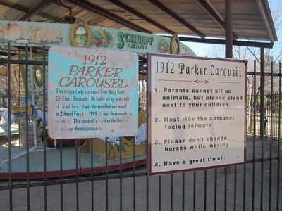
This carousel was purchased from Wally Scott, Elk River, Minnesota. He had it set up in the loft of his old barn. It was disassembled and moved to Schnepf Farms in 1999. It took three months to refurbish. This carousel is listed on the National . . . — — Map (db m94477) HM
Wright visited Arizona in 1927 when he was asked to consult on the designs for the Arizona Biltmore. In the years following that visit, Wright and draughtsmen spent time at temporary sites in Arizona including a desert camp they constructed near . . . — — Map (db m40613) HM
I have personally visited Pipe Spring several times and realize the desirableness of having this area established as a National Monument for the benefit of motorists traveling between Zion and Grand Canyon Parks. —Director Stephen . . . — — Map (db m149343) HM
He laid the foundation of the National Park Service, defining and establishing the policies under which its areas shall be developed and conserved unimpaired for future generations. There will never come an end to the good that he has done. — — Map (db m149341) HM
Established May 31, 1923
Through effort of Stephen T. Mather and friends
Pipe Springs
Occupied in 1863 by Dr. James M. Whitmore, who, with Robert McIntyre, was killed 4 miles S.E. Of here January 3, 1866 by Navajo and Piute . . . — — Map (db m131296) HM
Dedicated in Memory of
Charles Metcalfe
1855-1943
He deeded in perpetuity this land as a park for the use of Kingman youth. Recognized as a civic leader and land developer, He proposed development of Hualapai Mountain Park. He held . . . — — Map (db m29362) HM
Engine 3759
Engine No. 3759, is a mighty steam engine from an era nearly 100 years ago. An era of iron horses that sped across thousands of miles; an era that has always been entwined with Kingman. But just what is No. 3759, besides one of . . . — — Map (db m194743) HM
With its rugged mountains, deep canyons, stark deserts, and two large blue lakes, America's first national recreation area is a place of great contrasts. Lake Mead National Recreation Area (NRA) was established in 1964, well after the waters of the . . . — — Map (db m193366) HM
The Rainbow Forest area was the original park head-quarters from 1906 to 1962. In the 1920s, the museum was housed in a tar paper building and instead of a walking trail, a bumpy road wove through Giant Logs. Clearly, many things have changed. But . . . — — Map (db m187257) HM
Petrified Forest is a laboratory where scientists study not only the fossil record, but the records of earlier discoveries by naturalists and paleontologists.
Interest in the area’s fossils goes back to 1853, when a U.S. Army expedition . . . — — Map (db m68873) HM
He laid the foundation of the National Park Service, defining and establishing the policies under which its areas shall be developed and conserved unimpaired for future generations. There will never come an end to the good that he has done. — — Map (db m71151) HM
This contact station has served many purposes over the years, including an essential role as the monument’s first interpretive center.
The Cook Shack The building was originally constructed in 1939 as a nine-by-twelve-foot cook shack for . . . — — Map (db m144354) HM
You are standing in the oldest section of the pueblo, the Central Plaza. At one time, the rooms surrounding the plaza may have stood as high as three stories. Traditionally, the plaza area symbolized the Center of the Universe and played an integral . . . — — Map (db m187324) HM
In the distance, you can see several mesas. These are called Tuutukwi or the Hopi Buttes, sacred places in Hopi religion. Today, they are used as eagle gathering areas by certain Hopi clans.
Below you are the remains of the East Plaza. Like the . . . — — Map (db m187322) HM
Around A.D. 1330, a group of people arrived from the Hopi Mesas, 60 miles north, drawn by the lush flood plain of the Little Colorado River. These people built a 1200 room village; 750 to 1000 people lived in this pueblo.
The people farmed in . . . — — Map (db m187265) HM
These large holes, and others visible throughout the pueblo, are the result of illegal digging by treasure seekers and pot hunters. Such acts of careless vandalism not only destroy scientific information, but desecrate ancient and sacred burials. . . . — — Map (db m187267) HM
In the depression is a kiva. Kiva means "cellar" or "underground house". Men are primary users of kivas; women and children have access during certain ceremonies and seasons.
This kiva is 14 by 17 feet and 6 feet deep. The floor and benches were . . . — — Map (db m187268) HM
On the horizon are the highest mountains in Arizona, the San Francisco Peaks (12,670 feet). The Hopi call them Nuvatukya'ovi and believe they are the home of the Katsina spirits. Katsina are supernatural beings with the power to bring the rain . . . — — Map (db m187271) HM
Below you is Paayu, the Hopi name for the Little Colorado River, a year round source of water. Even when dry, water can be found a few feet below the sand. Paayu supported a variety of plant and animal resources, including beaver, elk, antelope, . . . — — Map (db m187270) HM
This area was dedicated on September 11, 1999 as a tribute to the memorable song of the 1970's that made Winslow, Arizona a town to sing about on famous Route 66. — — Map (db m36329) HM
A typical room used for domestic activities would have slab-lined floor pits for cooking and heating similar to those found here in the West Plaza. Storage rooms lacked such floor features.
To the left of these five rooms is an area that was . . . — — Map (db m187266) HM
Arizona State Parks preserved this vandalized kiva. It is the largest of the kivas in Homol'ovi II and measures 19.7 by 32.8 feet and is 6.6 feet deep. The pit near the south end of the structure is a hearth, and the small stone wall deflects and . . . — — Map (db m187269) HM
He laid the foundation of the National Park Service. Defining and establishing the policies under which its areas shall be developed and conserved unimpaired for future generations. There will never come an end to the good that he has done. — — Map (db m27206) HM
Colonel William Boyce Thompson was a mining promoter, financial magnate, and Red Cross officer. He fell in love with the Picketpost Mountain area when he first visited his Magma Copper Mine near Superior and chose this spot for his winter home. . . . — — Map (db m117109) HM
Laura Williams owned the antique museum which housed numerous artifacts from Jerome. Laura was one of the founding members of the Jerome Historical Society and served as the Secretary/Treasurer from 1953-1974. She was an employee of Newmont . . . — — Map (db m33189) HM
In 1932, Charles Bell constructed this trail through the rugged canyon of Wet Beater Creek. It was, and still is, used to move cattle up and down the Mogollon Rim. Bell Trail is six miles to the edge of the Rim and climbs a rocky 1200 feet in the . . . — — Map (db m187583) HM
An Arizona natural wonder in continuous operation since 1927.
Recognized by Hampton Hotels Save-A-Landmark program as a site worth seeing — — Map (db m194739) HM
Since 1908, the area of Prescott now known as Ken Lindley Field has been used as a public park and ballfield. The land was deeded to the City of Prescott by Charles T. and Ada M. Joslin in 1922. As Mrs. Joslin requested, the City later . . . — — Map (db m21161) HM
The Pioneer Trail was developed in 1932 to give access to the Pioneer Monument and commemorative plaque at the end of the trail.
Improvements to the trail were completed in May 2019 as a joint project of the Yavapai Questers and Cole Ortagus' . . . — — Map (db m151185) HM
All water for the prison came from the river. Inmates dug a network of tunnels at the base of the hill which would fill with river water. From there water was pumped up into the 85,000 gallon granite-walled tank, also of inmate construction. In . . . — — Map (db m185955) HM
The "New Yard" was constructed in 1900 to help relieve overcrowding. The entrance to the library was closed and the first four cells were made from the library excavation in the south bank. Eight more cells were dug into the east side of the same . . . — — Map (db m185959) HM
Anything a prisoner could not make himself or barter for, he had to do without. As an inmate, forty-eight hours a week were spent working in the fields, quarry, adobe yard, or on assignment in a shop. Whether you needed a tin cup or a new . . . — — Map (db m158293) HM
• Cast in 1875
• Stands approximately 3 feet high
• Weighs approximately 800 lbs. with carriage
This bell was cast by W.T. Garratt's Brass and Bell Foundry in San Francisco, California in 1875. A sailing ship brought the bell up the . . . — — Map (db m185957) HM
Restoration in Progress The Yuma East Wetlands (YEW) is an innovative restoration project pioneered by the Quechan Indian Tribe and the City of Yuma. The 1,418 acres of the YEW are comprised of native riparian wetland, and aquatic habitats . . . — — Map (db m158390) HM
This Stone Was Taken
from
Ruins of Old Bank, built
at
Arkansas Post, 1839.
Arkansas Post State Park.
Created by Act of Legislature 1929.
Introduced by Ballard Deane,
Representative, Arkansas County.
Act . . . — — Map (db m108550) HM
The Osage Nation first used the area now known as Bentonville for their hunting grounds. The Osage would leave their settlements to hunt in present day Benton County for months at a time before returning to their families. Settlers first . . . — — Map (db m237837) HM
Restoring the Twin Springs Park & Gardens
In January of 2003, the Siloam Springs Garden Restoration Club, an affiliate of the Arkansas State Federation of Garden Clubs, took on the task of restoring the Twin Springs Park historic garden. . . . — — Map (db m220476) HM
Founded in 1889 has been entered into the National Registry of Historical Places by the United States Department of the Interior on 7-8-99. — — Map (db m224982) HM
Resort home built 1899 by William Henry Reid of Chicago. Architect Theodore C. Link of St. Louis. Design reflects simplicity favored at end of Victorian era. Upper floors are wood with verandas on four sides. Lower floor is Beaver Limestone. In . . . — — Map (db m80118) HM
Any metal object placed in the spring
water was widely claimed to become
magnetized. It was also claimed that
exclusive use of the water from
Magnetic Spring would cure physical
debility and aid in overcoming drug
addiction. Drug addiction . . . — — Map (db m225223) HM
I stood here growing so many years,
I shared your laughter, I shared your tears.
My life was good, beginning to end,
and this is a wish I'd like to send.
Be happy and kind to all around,
and let not sorrow be ever found.
The spirit of . . . — — Map (db m59971) HM
May 20, 1886...
America's newest and most luxurious hotel built at a cost of $294,000.
It was two years ago that Powell Clayton and his associates chose the site of the new Crescent Hotel... twenty seven acres at the north end of West . . . — — Map (db m80116) HM
"It is sometimes called The Basin Springs, and is invariably the first resort for visitors. If there is any one in the city you desire to find, if no other way, go to the Basin Springs, seat yourself comfortable, and await his coming."
Prof. . . . — — Map (db m63300) HM
Dr. Thomas William Hardison was a resident of Petit Jean
Mountain for nearly half a century: Struck by the beauty and
natural wonders of the land, he was among the first to
imagine creating a park here to preserve its pristine grandeur
for . . . — — Map (db m233669) HM
During the "roaring twenties" and the following decade of the Great Depression, this location on Petit Jean Mountain,
known as Stout's Point, saw changes that would influence the history of Petit Jean State Park.
In 1920, the Morrilton Chamber . . . — — Map (db m233668) HM
William Cummings Stout
(1824-1886)
In 1849, William Cummings Stout
was the first Arkansan ordained as
a priest of the Episcopal Church.
In 1855, he and his wife purchased
5000 acres spanning both sides of
the Arkansas River beginning . . . — — Map (db m233667) HM
You are standing in a place that inspired establishment of
Petit Jean State Park and the entire Arkansas State Parks system.
A Lasting Legacy
Dr. T. W. Hardison is considered the father of
Arkansas State Parks. A long time resident . . . — — Map (db m233680) HM
When the Civilian Conservation Corps worked at Petit Jean in the 1930s, Dionicio Rodríguez, a
Mexican-born artist, sculpted this small bridge above a goldfish pond in a flower garden. He also
sculpted a flower basket that is in rubble on the north . . . — — Map (db m233676) HM
This statue honors Civilian Conservation Corps
Company V-1781. these skilled veterans of World War
One built Arkansas's first state park. — — Map (db m233674) HM WM
Davies Bridge, a sturdy Rustic-style structure, stands today as an emblem of the park's Civilian
Conservation Corps (CCC) heritage and the Davies family's contributions to Arkansas State Parks.
In 1932, Samuel G. Davies, a graduate of . . . — — Map (db m233672) HM
Through time, Cedar Falls has cut through vast layers of
sandstone, creating Cedar Creek Canyon which reaches a
depth of 400 feet.
The rock layer capping Petit Jean Mountain is sandstone, an
ancient sedimentary formation deposited as sand in a . . . — — Map (db m233681) HM
As you explore these unique structures around Petit Jean State Park,
you will find that nature and history are strongly connected here.
Rock House Cave - Explore this sandstone
bluff shelter and look for ancient Native
American . . . — — Map (db m233679) HM
Company V-1781 was the
designation of Petit Jean's CCC.
camp. The "V" indicated the
company employed World War I
veterans. The situation was
relatively unique: only 10 percent
of CCC camps around the United
States were veteran camps. . . . — — Map (db m233675) HM
Formed over eons, this inspiring landscape offers us a sense of wonder.
The landscape of Petit Jean State Park reveals a
story of stone, weather, and time.
Much of Petit Jean's exceptional landscape results from
earthen rock . . . — — Map (db m233687) HM
Welcome to Northeast Arkansas Pick up your Discovery our guide in the part visitor for center.
From pre-history to today, people have come here for a variety of reasons. Settlers found a state rich in wildlife and wilderness. Ancient . . . — — Map (db m232112) HM
Named in honor of Simon’s Grocery & Bakery and the Simon family who owned and operated the store for over 52 years on Front Street. Brothers George and Fritz Simon, along with other family members and employees, helped make the store a special part . . . — — Map (db m237134) HM
The dam seen here was constructed in 1887 & 1888 for the Mammoth Spring Milling Company. Each stone was hand-quarried and fit into place using no mechanical equipment. The concrete structure, to your left on the far side of the dam, is all that . . . — — Map (db m192074) HM
Mammoth Spring has been designated a National Natural Landmark This site possesses exceptional value as an illustration of the Nation's natural heritage and contributes to a better understanding of man’s environment 1990 National Park . . . — — Map (db m192000) HM
In 1890, the first Reunion of the Blue and Gray was held at Mammoth Spring, attracting Civil War veterans on both sides from Northern Arkansas and Southern Missouri. It quickly became a popular August event, with most participants arriving . . . — — Map (db m192166) HM
This U.S. Model 1861 4.5-inch Ordnance Rifle was known locally as "The Big Gun." The annual Reunion of the Blue and Gray, held at Mammoth Spring, became so popular the U.S. War Department furnished this cannon in 1893. During reunion week, it . . . — — Map (db m192167) HM
How has the spring helped the development of Mammoth Spring? The constant flow of water provided a reliable source of power as early as 1835, when a grist mill was located on the banks of the river. As the city flourished, the dam was . . . — — Map (db m192165) HM
You are standing on the support for a bridge across Spring Lake. The bridge provided an important link between the train station and the city of Mammoth Spring. The first bridge, made of wood, was replaced by a steel bridge. The steel bridge was . . . — — Map (db m192168) HM
The buildings along Bathhouse Row are the latest stage in a succession of bathhouses. In the 1830s Hot Springs’ earliest facilities were makeshift shelters perched over individual springs. Later, elaborate Victorian bathhouses flourished along . . . — — Map (db m61774) HM
From its opening the handsome Buckstaff Bathhouse aggressively promoted its image. To gain customers the owners mounted a huge sign on the roof to attract people from the large hotels a block away. Other bathhouses lost character as they modernized, . . . — — Map (db m61793) HM
After crossing the lower slopes of Hot Springs Mountain, this "red" trail connects with Gulpha Gorge Trail on a ridge above Gulpha Gorge Campground. The Short Cut Trail leads to the summit.
Historic Exercise Trail
For the next 0.2 mile . . . — — Map (db m145671) HM
Inspired by the spas of Europe, Colonel Samuel Fordyce opened this Renaissance Revival bathhouse in 1915. With its copper-framed glass marquee and elegant window design, the Fordyce reflects a crowning achievement of the Golden Age of Bathing.
Its . . . — — Map (db m61771) HM
Other than the hot baths, hiking the mountain trails was the biggest reason for baseball players to train in Hot Springs. Much of the legendary stamina of pitching legends Cy Young, Walter Johnson, Babe Ruth, and Lefty Grove was forged by hiking the . . . — — Map (db m190715) HM
Spas thrive on pleasant diversions. In contrast to sedate Bathhouse Row, Happy Hollow developed a a free-wheeling carnival atmosphere.
At the turn of the century, Norman Mcleod opened an amusement park in the vicinity of this cold spring and . . . — — Map (db m145652) HM
Following the Civil War, the
number of visitors to the springs
increased each year. By the early
1870s Hot Springs had gained
widespread popularity across the
nation as a famous health resort. — — Map (db m211135) HM
The present masonry Lamar Bathhouse, completed in 1923, has a symmetrical, California style of architecture. The large lobby contains nostalgic murals of historic landscapes, and country scenes.
Art Deco stairs, signs, and lights decorated the . . . — — Map (db m61777) HM
In 1911 the Maurice Bathhouse Company replaced an elegant but wooden Victorian building with the bathhouse you see today. The Mediterranean style masonry structure set the standard for all other bathhouses on Bathhouse Row.
The building is awash . . . — — Map (db m211012) HM
The mission style of the Ozark Bathhouse may relate to the claim that Spanish explorer Hernando de Soto visited the hot springs. The building’s twin towers are strictly decorative. On Bathhouse Row, the Quapaw, the Fordyce, and Hale Bathhouses, . . . — — Map (db m61794) HM
The Peak Trail is a short, moderately steep route up Hot Springs Mountain.
The summit has been a traditional site for observation towers. Unlike the 216-foot-high steel structure of today, the earliest wooden tower of the 1870s barely . . . — — Map (db m145684) HM
This spring remained open long after others were enclosed and diverted to bathhouses. It was common for the water of each hot spring to have a reputation for curing particular ailments, and the shallow water in this pool led naturally to foot . . . — — Map (db m145651) HM
As you view the formal entrance to Hot Springs National Park today, several pieces of the original architectural design from the 1890s are no longer present. For example, a distinctive stone and wood pavilion called the Bandstand graced the top of . . . — — Map (db m145650) HM
The Tufa Terrace Trail passes historic Ral Spring and follows a fairly level path across the hillside before rejoining the Grand Promenade. From there you can stroll the Grand Promenade or descend past the Thermal Cascade to Arlington Lawn. . . . — — Map (db m145670) HM
Norman Evans McLeod was born in Georgia in 1853 and took an interest in photography
as a teenager. After college he wandered the country, finally settling in Hot Springs in
1888. He originally created McLeod's Happy Hollow Studio near Happy . . . — — Map (db m220364) HM
In addition to the hot springs for which, the park is known, there are many cold springs within the park's boundaries. The springs come from underground aquifers, which are layers of porous or fractured rock filled with water. Water in aquifers is . . . — — Map (db m234364) HM
The luxurious Imperial Bathhouse was built on this location in 1893, offering wealthy bathers deluxe amenities almost two decades before the opulent Maurice and Fordyce bathhouses would dominate Bathhouse Row. The red brick building was constructed . . . — — Map (db m234384) HM
In 1877, Enoch Woolman built a wooden observation tower on Hot Springs Mountain that was 80 feet tall. The tower became a popular attraction with the public and rewarded visitors with picturesque views of the surrounding area. Sometime between 1885 . . . — — Map (db m234365) HM
Native Americans have occupied the land we now call Hot Springs National Park for well over 10,000 years. This land was part of their hunting grounds, but also offered prime quarrying sites for stone to make sharp-edged, durable tools and weapons. . . . — — Map (db m234367) HM
As early as the 1840s the bathhouses were capping springs to control and use them. These springs evoke pre-development days when water flowed freely from the mountainside. The water of Open Springs has an average temperature of 134°F (56°C).
. . . — — Map (db m234382) HM
The first trail shelter was built in May of 1924, along the ridgeline between North Mountain and Hot Springs Mountain. It was part of the construction of the trail that led down to the Gulpa Gorge Campground. The building was a small, stone, open . . . — — Map (db m234366) HM
Crowley's Ridge State Park is here today due to the hard work, dedication, and
ingenuity of the local community and the Civilian Conservation Corps.
Crowley's Ridge State Park is home to log and stone structures
built by the Civilian . . . — — Map (db m170555) HM
This dog park is named in honor of Batesville native
Sara Elizabeth Low. Throughout her youth, she was
known for her kindness and helpfulness to others. Sara
carried these traits through adulthood and was remembered
for them by fellow crew . . . — — Map (db m242386) HM
Jacksonport's unique location at the meeting of the Black and White Rivers shaped its history and natural resources. Founded as a river port town in the mid-19th century, it thrived on the steamboat trade. This traffic made the town a center of . . . — — Map (db m221244) HM
The Arkansas Flag/Wabbaseka Memorial was founded by Jason Irby in 2013. Jason is an author and humanitarian who grew up in Wabbaseka and attended the public schools around the city. Jason attended Willie K. Hocker Elementary/Jr. High schools, . . . — — Map (db m169051) HM
In 1815 Lawrence County was formed from the Territory of Missouri. It became part of the Arkansas Territory in 1819 when Missouri became a state. Thirty-one other counties were formed from Lawrence County, giving it the name, "Mother of Counties." . . . — — Map (db m155965) HM
The Powhatan jail housed prisoners for 57 years. Due to increasing security problems, the jail closed in the 1920s A new jail at Walnut Ridge replaced this one after World War 1.
From 1850 an 1935 this building was a canning kitchen. From . . . — — Map (db m242656) HM
Eiffel Tower Park was established in 2014 on the West side of the
Paris town square. The Eiffel Tower was a gift to the city by a former
resident and pastor, Don Eubanks. A 7 foot water feature with fountain
was added to the 18 foot tower to . . . — — Map (db m129685) HM
1541 - When Desoto brought his Spanish conquistadores to this area in 1541, he found an industrious Caddo Indian tribe who inhabited and enjoyed the area that was later to become Miller County, Arkansas. Along the Red River the Caddo farmed, . . . — — Map (db m173500) HM
Before Lewis and Clark explored the Louisiana Territory in 1804, little was known about the land or the animals of this vast region. President Jefferson, interested in America's natural resources, instructed the expedition to collect specimens and . . . — — Map (db m155194) HM
This park preserves and protects two of Arkansas's greatest heritages: The "initial point" of the 1815 Louisiana Territory land survey and one of the state's few "headwater" swamps. The elevated boardwalk allows for safe viewing of the park's . . . — — Map (db m155180) HM
This point was established by survey on November 10, 1815 by U.S. Government survey teams led by Prospect Robbins and Joseph Brown. Recognizing the national significance of this Initial Point, the L'Anguille Chapter of the DAR sought placement of a . . . — — Map (db m155200) HM
President Thomas Jefferson learned Spain had ceded the Louisiana Territory back to France in early 1801. Fearing Napoleon would close the Mississippi to American trade, the President sent Ambassador Robert Livingston to Paris (September, 1801) to . . . — — Map (db m155195) HM
The official Survey of the Louisiana Territory was ordered in 1815 by President Madison to establish a system for distributing this land as payment to veterans of the War of 1812. Commissioned by the United States Government, Prospect K. Robbins . . . — — Map (db m155197) HM
Louisiana Purchase Historic State Park is situated in an unusual habitat — a "headwater" swamp. This swamp differs greatly from the more common "backwater" swamps. Found within the floodplain zones of large streams and rivers, backwater swamps . . . — — Map (db m155188) HM
The stone marker behind you marks the 'Initial Point' for the survey of the Louisiana Purchase Territory. The east-west Baseline and the north-south line, the Fifth Principal Meridian, are fundamental in land transactions throughout the western . . . — — Map (db m155199) HM
The Mississippi River defines Helena
The Mississippi River has for centuries been the backbone of life in Helena; fertilizing its soil, supporting its farms and businesses, connecting people and cultures. Despite this rich history, there . . . — — Map (db m231812) HM