On County Road 99 north of County Road 68W, on the right when traveling north.
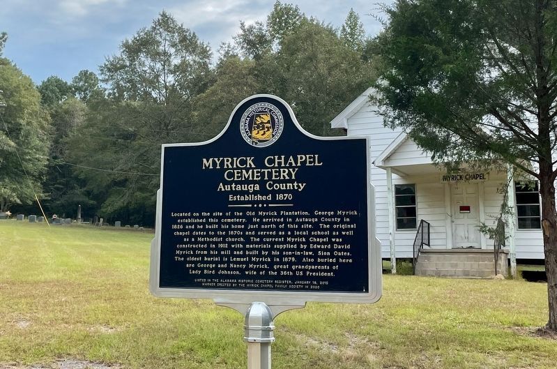
Located on the site of the Old Myrick Plantation, George Myrick
established this cemetery. He arrived in Autauga County in
1826 and he built his home just north of this site. The original
chapel dates to the 1870s and served as a local school as . . . — — Map (db m206686) HM
On Alabama Route 14, 0.4 miles west of County Road 9, on the right when traveling west.
Constructed in 1854, Ivy Creek Methodist Church originally was part of the Mulberry Beat in Autagua County. The church served the communities of Hamilton, Huckabee (Evergreen), Milton, Statesville-Mulberry, and West Autaugaville. Ivy Creek Methodist . . . — — Map (db m158666) HM
On East 4th Street at South Chestnut Street, on the right when traveling east on East 4th Street.
Side 1
Daniel Pratt
Founder of Prattville
Daniel Pratt, a native of New Hampshire, became an industrialist, statesman and philanthropist in Alabama. He was a Methodist in both heart and practice. He encourage the development of the . . . — — Map (db m70813) HM
On East 3rd Street at South Chestnut Street, on the right when traveling east on East 3rd Street.
Side 1
First Presbyterian Church of Prattville, Alabama
Organized 1846 by Pastor Wm. H. Mitchell, this congregation succeeded Millenium Hope Presbyterian, 2 mi. E. of town. Pastor Jas. K. Hazen (1861-77) married Mary Ticknor, . . . — — Map (db m81479) HM
On East Sixth Street, 0.4 miles east of North Northington Street, on the right when traveling west.
Known as Fair Road, Sixth Street from Northington Street to the big curve was called “Happy Hollow”. The road went to the Fair home place but also curved right, into Warren Circle. Here stood a small frame church where the congregation’s . . . — — Map (db m70800) HM
On Dosterville Road, 1.5 miles west of South Memorial Drive (U.S. 31), on the left when traveling west.
Indian Springs Post Office
Location of considerable Community activity in the early nineteenth-century Autauga County
Thomas Hill House
Site of first Court after Autauga became a County
Union Baptist Meeting House
1830s . . . — — Map (db m70798) HM
On Rocky Mount Road, 1.1 miles north of Cobbs Ford Road (U.S. 82), on the right when traveling north.
Rocky Mount Cemetery was established on this sacred ground for families who settled Cobb’s Ford and the surrounding area. The oldest marked burials date to the 1890s. Numerous veterans of the Civil War and World Wars I and II are buried here. Rocky . . . — — Map (db m158661) HM
On East 4th Street at South Washington Street, on the right when traveling east on East 4th Street.
Saint Mark's was organized in 1859 as a mission of the Diocese of Alabama. Services were first held at the Presbyterian Church and in the old Court House. In December 1876, the congregation purchased an old wooden frame chapel from the Methodists . . . — — Map (db m70801) HM
On County Road 21 south of County Road 20, on the right when traveling south.
In 1870, Marbury Lumber Company donated land for the White Pond Methodist Church and Cemetery. It is believed that the first burial in the cemetery, marked only by a pile of bricks, took place that same year. The earliest marked grave is of Thomas . . . — — Map (db m158662) HM
On Courthouse Square (U.S. 31) at Hand Avenue, on the left when traveling west on Courthouse Square.
Born and educated in England, Toulmin became a Unitarian Minister and fled persecution in 1793. In the U.S. he served as President of Transylvania University and Secretary of the State of Kentucky. In 1804 Thomas Jefferson appointed him as the first . . . — — Map (db m100850) HM
This church and cemetery have been in continuous service by the citizens of this area since the 1840's. Originally named "Methodist Episcopal Church South." Land donated by William L. Howard. Building built by L. E. Edmondson and a Creole helper, . . . — — Map (db m49260) HM
On Main Street (County Road 98) at Magnolia Avenue, on the right when traveling north on Main Street.
On April 15, 1867, Major Lewis Starke deeded these two acres to four of his ex-slaves and their heirs as trustees for this church: Nimrod Lovett, Stamford Starlin (now Sterling), Narcis Elwa, and Benjamin Franklin.
In this cemetery is buried . . . — — Map (db m100851) HM
Near Dixie Graves Parkway (State Highway 180) when traveling west.
First Alabama soldier to lose life in Civil War.
DeVotie graduated in 1856 from University of Alabama; Presbyterian Theological Seminary at Princeton in 1859. In 1856 at the University of Alabama, he was chief founder of Sigma Alpha . . . — — Map (db m4219) HM
On Alabama Route 180 east of Gasque Lane, on the right when traveling west.
This Shell Banks Baptist Church rests near the location of the first Indian village in America visited by a white man. This was the Indian village of “Achuse” visited by Admiral Maldonado who was one of De Soto’s officers. He scouted . . . — — Map (db m66295) HM
On Old Stage Road north of Alabama Route 59, on the left when traveling north.
First known as Baldwin Presbyterian Church, members met in 1847, in Old Union Church near John Gallagher Springs. In 1903, the membership was moved to this site and the name was changed to Stockton Presbyterian Church. In 1956, the membership moved . . . — — Map (db m66387) HM
On Alabama Route 131 at Dennis Road, on the left when traveling west on State Route 131.
Established c 1895, Freemount Junior High School was an important black school in the Eufaula area. It was originally established within the Freemount AME Church which once stood about 300 feet south of this site. The school was later moved to this . . . — — Map (db m164938) HM
On U.S. 82 at County Route 79, on the right when traveling east on U.S. 82.
Side 1
In 1828, Reverend John Wesley Norton left his native South Carolina with his family and a wagon train of followers, crossed into the Creek Indian Nation and just into the edge of what was then Pike County, settling near the . . . — — Map (db m78123) HM
On John Scott Road near Bethel Road, on the left when traveling south.
Organized and constituted April 11, 1835. A committee called brethren John Tew and Solomon Sikes as presbyters. The presbyters, finding the brethren orthodox in faith, constituted a church which they named Bethel. Founders migrated from Pa., N. C.. . . . — — Map (db m220893) HM
On South Midway Street, on the right when traveling south.
This church had its origins in a mission station established by the Rev. J. L. Gay in 1844. On May 10, 1872 the mission was formally accepted in the Diocese of Alabama as Grace Church. Construction of a church building began in 1875 on a lot owned . . . — — Map (db m60756) HM
Church founded in 1835 and rebuilt in 1947. Union Baptist Church is the second oldest Baptist church in Barbour County.
In memory of Reverend John L. Dowling.
Loving husband and father. — — Map (db m60800) HM
On Alabama Route 51 north of Clio Short Road, on the right when traveling north.
Barbour County’s “Little Scotland”
In the 1820’s before the Creek Indian Cession, Scot immigrants from Richmond County, North Carolina, settled this area of west Barbour County. Few other regions outside the motherland of . . . — — Map (db m89605) HM
Near Alabama Route 51 north of Clio Short Road, on the right when traveling north.
To the memory of the African slaves who lived, worked, worshipped and died here at April, 1857. These 23 were baptized members of the Pea River Presbyterian Church
Moses · Dilley · Hanner
Mary · Calvin · Sarah
Henry · Anakey · Hannah . . . — — Map (db m187391) HM
On Alabama 51 (Alabama Route 51) 0.1 miles north of Clio Short Road, on the right when traveling north.
This cemetery is the final resting place for many early pioneers who settled this area of Alabama. More than six generations of families from the surrounding communities including county elected officials, mayors of both Louisville and Clio, . . . — — Map (db m187390) HM
On East Barbour Street (U.S. 82) at South Eufaula Avenue (U.S. 431), on the right when traveling east on East Barbour Street.
The origins of this church date back to 1834 when Methodists, under the leadership of Jesse Burch and others, met to worship and formed a Sunday School. A frame Greek Revival edifice, at the corner of Livingston and Barbour Streets, was completed in . . . — — Map (db m75188) HM
On East Barbour Street (U.S. 82) at South Randolph Street, on the right when traveling west on East Barbour Street.
Irwinton Baptist Church was constituted on June 24, 1837. The name of the town changed to Eufaula in 1843, and consequently the name of the church became Eufaula Baptist Church. The church assumed its third name in 1869 when it was changed to First . . . — — Map (db m162277) HM
In 1836 sixteen Eufaula Presbyterians met in a room above William McKenzie’s store to hold worship services. By 1838 the congregation had built their first sanctuary dedicated to worship on the southeast corner of Forsyth Ave. and Union Street. . . . — — Map (db m60560) HM
On South Eufaula Avenue (U.S. 431), on the right when traveling south. Reported missing.
(Front): First known as White Oak Chapel this church was dedicated on October, 18, 1859 by Rev. Issac I. Tatum of the Alabama Conference Methodist Episcopal Church South. The Society was organized by Rev. John J. Cassady who served as pastor . . . — — Map (db m163401) HM
On Woody Johnson Road east of County Road 79, on the left when traveling east.
Robert Martin bought 1200 acres of land from the U.S. Government. He set aside eight acres to build a church for the community. This building has been used almost constantly since 1837. At times it was a Methodist Church; at times Baptist. It is now . . . — — Map (db m164709) HM
On Springhill Road (County Road 89), on the right when traveling west.
Constructed in the 1840s and constituted in 1852, Ramah Baptist
Church is in the community formerly known as both Ramah and
Vaughn. Records show that the land for both the church and
cemetery was given by Solomon G. and Francis T. Burke in . . . — — Map (db m158553) HM
On County Road 89 west of County Road 49, on the left when traveling west.
This Greek Revival church was built in 1841 by John Fletcher Comer with lumber from his mill. The building originally had a slave balcony and exterior stairway which were removed c. 1890. At the same time, the pulpit was moved from between the two . . . — — Map (db m188268) HM
On Montevallo Road (State Highway 25) at County Road 62, on the left when traveling west on Montevallo Road.
Absalom Pratt built this house 8 miles west of here circa 1835 though a section was constructed earlier. It was moved to this site in 1994 by the Cahaba Trace Commission, restored by the Alabama Historic Ironworks Commission, 1997-98, and dedicated . . . — — Map (db m37078) HM
On College Street at Church Street, on the right when traveling north on College Street.
First minister assigned to Alabama Territory by Tennessee Conference. Preached first sermon two blocks west at Bear Meat Cabin (present Blountsville) April 18, 1818. He later organized churches in Shelby, St. Clair, Jefferson, Tuscaloosa and Cotaco . . . — — Map (db m27991) HM
On County Road 36, 0.1 miles north of New Home Church Road, on the right when traveling north.
William M. Bailey (born 1859 in Cherokee Co.; died 1909 in Blount Co.) settled 40 acres on what became Co. Rd 36 to the west and New Home Church Rd to the east in 1893. He brought three small sons from Cherokee Co. after the death of his first wife . . . — — Map (db m42599) HM
On U.S. 29 just north of Twin Trail, on the right when traveling south.
The town of Aberfoil was incorporated January 26, 1839, in then Macon County, with the first election for councilors conducted and managed by Lewis Stoudenmire, Charles G. Lynch, Thomas Scott, David Hudson, and A. J. and E. A. Jackson. Aberfoil was . . . — — Map (db m61027) HM
On Fitzpatrick Road, 0.5 miles north of Alabama Route 110, on the right when traveling north.
Lacking an established church nearby, pioneer families of the Fitzpatrick community into the mid-19th century took turns hosting worship services in their homes on Sunday mornings. "The Church of the Seven Sisters" was established in 1858 by seven . . . — — Map (db m67158) HM
On Old Troy Road, on the left when traveling west.
The Macedonia Baptist Church, located between the communities of Midway and Mt. Coney, was constructed by freedmen after the American Civil War, replacing the brush arbors used by the area’s antebellum slaves as sites for religious worship. Four . . . — — Map (db m60947) HM
On Main Street, on the right when traveling south.
Midway, a part of Barbour County in the mid-19th century, was also known as Five Points, a small community of a handful of dwellings, two stores, and a Methodist church of logs. In this Methodist church, Joel Willis, J.M. Thornton, Robert G. Hall, . . . — — Map (db m60908) HM
On Railroad Street, on the right when traveling west.
St. James Christian Methodist Episcopal Church founded by Reverend Jack McMillan, a former slave of Midway’s Daniel McMillan. Initially meeting outdoors under a brush arbor, ex-slaves and their children constructed a wood-frame church building soon . . . — — Map (db m60909) HM
A 19th century cultural center located on the ridge dividing the coastal plain from the black belt originally Pike Co., Al.; Bullock Co. since 1866
Cemetery established in the 1830s for all faiths, situated between Mt. Hilliard Methodist . . . — — Map (db m181649) HM
On County Road 14, 1.3 miles west of County Road 15, on the left when traveling west.
Founded by settlers from Virginia, Georgia, and Carolinas. Building erected 1856. It was the central feature of the village of Mount Hilliard. Named in honor of Henry W. Hilliard -- who debated William L. Yancey in the 1850's. Revivals held at . . . — — Map (db m67553) HM
On State Highway 223 at County Road 22, on the left when traveling south on State Highway 223.
(side 1)
Settlers from the Edgefield District, South Carolina, organized the Sardis Baptist Church on June 10, 1837. The first building, a log cabin, was constructed in 1841 after John M. and his wife Amy Youngblood Dozier deeded four and . . . — — Map (db m67552) HM
On Blackmon Street (U.S. 82) at Prairie Street, on the right when traveling west on Blackmon Street.
Trinity Episcopal Church was established in Union Springs by Rev. DeBerniere Waddell in 1872 as a parish of the Episcopal Diocese of Alabama with seventeen communicants and an annual budget of $412.50. Until 1879 services were held monthly in the . . . — — Map (db m60973) HM
On Nickquenum Road, 2 miles south of Kirkville Road (County Road 75), on the left when traveling south.
In March 1863 Francis and Sarah Sheppard gave 3 acres of land to Methodist Episcopal Church South as a place for worship and burial. 2 more acres given by Alexander and Mary Sheppard Oct. 1868. Property sold to County Line Primitive Baptist Church . . . — — Map (db m70838) HM
Near Oakey Street Road at Halso Mill Road (County Route 59), on the right when traveling north.
Oakey Streak
The community of Oakey Streak was so named for the abundance of oak trees in the immediate vicinity. From 1829-1843 the post office here was known as Middletown and from 1853-1935 Oakey Streak. Nearby was the Dawson Masonic . . . — — Map (db m70757) HM
On East 10th Street west of Kirkwood Avenue, on the left when traveling east.
Outstanding local industrialist as President, Kilby Steel Company; Chairman, Board of Directors, Alabama Pipe Company; President, City National and Anniston National Banks. Served as Mayor of Anniston (1905-09); State Senator (1911-15); Lieutenant . . . — — Map (db m35758) HM
On East 10th Street west of Leighton Avenue, on the left when traveling east.
Called “A poem in cedar & stone,” its history is intimately related to that of Anniston: Town Founders, Daniel Tyler & Samuel Noble, inspired its conception, funded its construction & caused Woodstock Iron Co. to donate the land on which . . . — — Map (db m35759) HM
On Quintard Avenue (U.S. 431), on the right when traveling north.
On July 3, 1887, a congregation of 45 people met at the Opera House on Noble Street to organize a new church. Originally called Second Baptist Church, the name soon was changed to Twelfth Street Baptist Church.
In 1889, it became Parker . . . — — Map (db m36545) HM
On East D Street at South Christine Avenue, on the left when traveling east on East D Street.
Saint John, founded at the turn of the 19th century, is the first
African-American Methodist Episcopal Church in South Anniston.
The original structure was built in 1922. The current building was
erected in 1951 on the corner of D Street and . . . — — Map (db m144905) HM
On Quintard Avenue (U.S. 431) at East 18th Street, on the right when traveling south on Quintard Avenue.
Built by John Ward Noble, one of Anniston’s founders. Consecrated on September 29, 1890. Widely acclaimed for unique and beautiful Norman Gothic architecture. The church dominated by imposing 95 foot bell tower.
Open Daily — — Map (db m36540) HM
On West 17th Street at Cooper Avenue, on the right when traveling west on West 17th Street.
Seventeenth Street Missionary Baptist Church served as the home of "mass meetings" for black Annistonians who planned and executed Anniston's part of the Civil Rights Movement. Reverends D.C. Washington (1937-1960) and Nimrod Q. Reynolds . . . — — Map (db m106651) HM
On Quintard Avenue (U.S. 431) at East 13th Street, on the right when traveling north on Quintard Avenue.
Temple Beth El is the oldest building continuously used for Jewish worship in Alabama. Anniston’s Reform Jewish congregation was established in 1888. Its women’s organization, the Ladies Hebrew Benevolent Society, directed the construction of the . . . — — Map (db m36543) HM
In April 1888, the founder of a newly established Reform Jewish congregation purchased twenty-three lots in Hillside Cemetery to bury their deceased members.
In 1987, the City of Anniston vacated right-of-way that allowed the Temple to expand the . . . — — Map (db m53163) HM
On Clinton Street Southeast, on the right when traveling west.
This Church was used for a
Confederate Hospital
During the War
Between The States
Erected by
General John H. Forney
Chapter U.D.C. Sept 27, 1937 — — Map (db m36539) HM
On University Circle west of North Pelham Road (State Highway 21), on the right.
Lawyer, Industrialist, Patriot
Brigadier General, U.S.A.
Gen. Burke helped rebuild
Alabama’s mining & manufacturing
interests after the Civil War.
He helped establish the Catholic
Church at Jacksonville.
His home, . . . — — Map (db m36424) HM
On Ladiga Street Southeast at Church Avenue Southeast, on the right when traveling east on Ladiga Street Southeast.
John D. and Anna Maria Hoke founded the parish on June 30, 1844. Members of the Hoke, Forney, and Abernathy families joined over the years. The church design was based on Richard Upjohn's 1852 pattern book, Upjohn's Rural Architecture. Upjohn was . . . — — Map (db m199134) HM
On East Ladiga Street, on the left when traveling west.
The First Presbyterian Church of Piedmont was organized March 18, 1890, with seventeen charter members, by Rev. B. F. Bedinger, Presbyterian evangelist. Rev. J. E. McLean was the first minister. First elders were C. W. McMahon and Stephen Ferguson; . . . — — Map (db m27993) HM
On North Main Street at Alabama Street on North Main Street.
Beginning as a Methodist mission in the 1850's, the Piedmont First United Methodist Church was organized in 1867 as the Cross Plains Methodist Episcopal Church, South, by Wilson Johnson and a small band of local Methodists. In 1868 a small church . . . — — Map (db m83261) HM
On 5 Points Fredonia Road (County Road 222) east of County Road 267, on the right when traveling east.
From its foundation, Fredonia was the educational and trade center for northeast section of Chambers County. "The Southern Military Academy" was established in the village by the state legislature and forced to close by the civil strife. Sixteen . . . — — Map (db m197957) HM
On 1st Street Southeast at 2nd Avenue Southeast, on the right when traveling north on 1st Street Southeast.
This structure was built by early settlers from Virginia, Tennessee, and the Carolinas, and subsequently modified. The original building has stood since 1836.
Union Sunday School begun here in 1891. Many eminent ministers have filled the . . . — — Map (db m83264) HM
On Country Club Road, 1.6 miles west of County Road 210, on the left when traveling west.
Side 1
Providence Baptist Church was organized before 1836 by Elder Francis Calloway. It was one of the ten charter churches of the East Liberty Baptist Association. The small white frame church was built during the ministry of Reverend . . . — — Map (db m83265) HM
On U.S. 431 near County Road 23, on the right when traveling north.
Near this site stood the Oak Bowery Female Institute,
opened in 1849 under auspices of the Methodist church. Masons
established the East Alabama Masonic Institute for Young Men
Among Oak Bowery's noteworthy citizens:
William J. Samford. Alabama . . . — — Map (db m151222) HM
On Boulevard at Scott Street, on the right when traveling south on Boulevard.
Side 1
Built 1916 by West Point Mfg. Co. and called Fairfax “Union” Church as it was shared by Disciples of Christ, Methodist, & Baptist groups. It was purchased by the Disciples of Christ after the others left to build their . . . — — Map (db m83266) HM
On West Main Street at Watson Drive, on the right when traveling west on West Main Street.
Mose Hampton bought his freedom prior to the Civil War. He was a builder, assisted in laying out and surveying the town of Centre, a minister in the Episcopal Methodist North, and an inventor. Mr. Hampton owned land in the vicinity of this marker on . . . — — Map (db m120046) HM
On County Route 33 at County Route 29, on the left when traveling south on County Route 33.
In 1835, pioneering families migrated from Morgan County, Georgia to Cherokee County, AL, settling in the Ambersonville area, later renamed Spring Garden. These families were members of Carmel Presbyterian Church in Morgan County and brought their . . . — — Map (db m132792) HM
On County Route 458, on the right when traveling north.
Arthur Love, a charter member, was first pastor. Organized as a Methodist Episcopal Church. Became Methodist Protestant, 1828. Changed to Methodist Church, 1939. Affiliated with United Methodist, 1968. In the original church built of logs, Judge . . . — — Map (db m83268) HM
On Railroad Street north of Main Street (State Route 22), on the left when traveling north.
This structure is an excellent example of the one-room Gothic Revival - style church buildings which once were built throughout the South. It was originally located on a three-acre site that was deeded to trustees W. A. D. Ramsey, G. W. Brand, and . . . — — Map (db m37615) HM
A number of Soldiers' Home veterans were members of this church over the years. It originally had a second floor for Sunday School classes and a cupola on the roof.
With the closing of the local lumber mill in 1910 the population of the town . . . — — Map (db m129424) HM
On Alabama 22 at County Road 45, on the right when traveling south on Alabama 22.
On July 31, 1819, Ebenezer Baptist Church was constituted by Isaac Suttle, Lewis C. Davis (“Old Club Axe”), and William Harrod. The first house of worship was a large log house located one mile south of this site, near Bogle's Creek. After fire . . . — — Map (db m217203) HM
Near County Road 45, 0.3 miles west of State Route 22, on the right when traveling north.
Cavalry engagement here among fiercest of war.
To defend arsenal at Selma Forrest (CSA) charged with 1500 into Wilson (USA) moving south with 7500.
Forrest was seeking to delay Wilson pending arrival of . . . — — Map (db m37617) HM
On County Road 59, 0.1 miles south of U.S. 31, on the right when traveling south.
The only community in the U.S. so designated, Verbena was named for the profuse wild flowers growing in the area. Settlers arrived in the area as early as 1832. Completion of the North-South Railroad and a train depot at Verbena in 1870 enabled . . . — — Map (db m68286) HM
On Little Drive (Little Place Cemetery Drive), 0.2 miles east of Ararat Road (County Route 23), on the left when traveling east.
Little Place Cemetery
Little Place Cemetery is a community cemetery that serves the African American Womack Hill community and its descendants. The establishment of the cemetery is linked to the founding of Mt. Pleasant Baptist Church, . . . — — Map (db m240385) HM
On Ararat Road (County Route 23) 7.2 miles north of Pleasant Hill Road, on the right when traveling east.
In 1871, Springhill Missionary Baptist Church was established. In 1875, William Johnson Sr. donated the land for the Springhill Missionary Baptist Church and Cemetery on Ararat Road. During the same year, work began on a permanent church building . . . — — Map (db m240457) HM
On Barlow Bend Road, 0.2 miles north of Madison Road (Route 33), on the left when traveling north.
First church building of record in Clarke County.
Erected here in 1810 by John French of Virginia,
who organized Methodist congregation here 1811.
Combined with Gainestown Church 1897. — — Map (db m101575) HM
On Ulcanush Lane, 0.1 miles north of Alabama Route 69, on the right when traveling north.
Oldest continuous church in Clarke County. Organized 1816 as a prayer meeting; constituted full Baptist church 1817. Charter members were Roedy Allen, Michael Miller, John & Elizabeth Pace, William Stringer, William & Nancy Thorton and Joseph . . . — — Map (db m203664) HM
On Main Street Circle west of Main Street South, on the right when traveling west.
Fulton, first known as Wade's Station, developed in the 1880s along the Mobile to Birmingham Railroad. With the railroad came an influx of lumbermen from the North. Marcus Behrman was the first of the lumbermen who came to establish a lumber mill . . . — — Map (db m203704) HM
Founded by the CME (Christian Methodist Episcopal) Church as the only school for black students in the area in the early 1900’s, Williams’ Temple eventually consolidated with another school in Booker City to form Miles College near Birmingham. . . . — — Map (db m101596) HM
On West Bend Road (County Route 31) north of Jamestown Lane, on the right when traveling north.
Settled 1809-1820 in what was Mississippi Territory. Alabama became a state Dec. 14, 1819. Early settlers — Turner-Thornton-Stringer-White-Scruggs-Pace-May. Turner's fort built 1812, located 1½ miles N. W. West Bend Academy est. 1859 and located . . . — — Map (db m203667) HM
On U.S. 84 at County Road 22, on the right when traveling west on U.S. 84.
February 16, 1826, November 8, 1913.
Minister, Teacher, Historian, Author.
His love of history, natural resources and mankind led him to record events, past and present, writing many of his notes on the pommel of his saddle and also walking . . . — — Map (db m83272) HM
On Main Street at Rickwood Drive, on the left when traveling east on Main Street.
Front
Originally home to Creek and Choctaw Indians, Whatley was first settled by pioneers about 1808. Some of the most famous events in Clarke County’s history happened in or near Whatley. A Creek War battle occurred here in 1812 at Fort . . . — — Map (db m110971) HM
On Winn Road (County Road 3) 0.7 miles north of Zimco Road (Route 23), on the right when traveling north.
Established 1858, ¼ mile east of here. Camp meetings were held in summers. Congregation moved to site near Peniel 1894. The "arbor" and church building were left at original site. These buildings convenient for annual encampment of county . . . — — Map (db m101579) HM
On 1st Avenue (Alabama Route 9) 0.1 miles north of 5th Street East, on the right when traveling north.
Side 1
Union Baptist Church. later named the First Baptist Church of Ashland, was founded with 23 charter members in 1865, six years before the town was incorporated. Members met in a log cabin in the southwestern part of Ashland. From . . . — — Map (db m95101) HM
On Cheaha Road (Alabama Route 49) at Nichols Street, on the right when traveling north on Cheaha Road.
The first Methodist Church in Lineville began in a brush arbor
before the Civil War. In 1861, this tract of land was donated for the
construction of a permanent structure, which was completed in 1866.
The pastor was the Rev. R. A. Timmons, a . . . — — Map (db m175282) HM
On County Route 639 at County Route 640, on the right when traveling west on County Route 639.
The first congregational meetings were held in a small former dwelling house.
In 1915 this congregation joined with the Alabama District of The Assemblies of God. First pastors were: Rev. Elijah Spence and Rev. Wayne Tomlin.
First deacons . . . — — Map (db m95357) HM
A congregation of the Methodist Episcopal Church, South existed in Elba even before Rev. Robert Shaw Rabb was assigned as the first minister to the Elba Circuit on December 15, 1853. This site was purchased in 1909 and the Church officially opened . . . — — Map (db m83274) HM
On South Main Street, on the right when traveling north.
Organized in 1883 by 13 charter members as Carmichael Chapel of Elba Circuit, the congregation originally worshipped in a brush arbor on the NW corner of N. Main and Lee Streets. The first two sanctuaries built in 1883 and 1893 were both located on . . . — — Map (db m54745) HM
On Alabama Route 27, on the right when traveling south.
Founded near Double Bridges Creek (LeCompte Place) three miles southwest of the present location. First Pastor: J. W. Bullard. Charter members: Mr. & Mrs. Thomas Mathis, Mr. & Mrs. Tom Barbee, Mr. & Mrs. Jack Nichols, Mr. & Mrs. Joe Jones, Mr. Bob . . . — — Map (db m83327) HM
On Alabama Route 51, on the left when traveling south.
Established 1858 Oldest official record is land deed
of December 29, 1853 for five acres to trustees I.T.
Law, William Mixson, William Dubose, Javor Dupee
and William Hendricks. Name was changed in 1868 to
Old Tabernacle after New Tabernacle . . . — — Map (db m204960) HM
On Mt. Pleasant Road (County Road 66) 0.3 miles east of County Line Road (County Road 48), on the right when traveling east.
Old Brick Church began in 1820 as the Mt. Pleasant Cumberland Presbyterian Church and met in a frame building which burned in 1824. The present building has undergone few changes since its construction in 1828 when the congregation was officially . . . — — Map (db m147370) HM
On Main Street, 0.1 miles south of 1st Street, on the right when traveling south.
Side 1
The region's rich history of Methodism predates the creation of
Colbert County. Local Methodists helped raise $10,000 to persuade
the Tennessee Methodist Conference to build LaGrange College (4
miles SW), which opened in 1830. . . . — — Map (db m153325) HM
On County Line Road (Alabama Route 99) 0.2 miles north of Bethel Cemetery Road, on the left when traveling north.
The church was organized as Bethel Missionary Baptist Church on June 26, 1819, with Elder Theophilous Skinner serving as pastor. The church predates the creation of the state of Alabama by nearly 6 months. Bethel’s original was across County Line . . . — — Map (db m213754) HM
On Old Hwy 20 east of Morgan Drive, on the right when traveling east.
(side 1)
The town of Leighton was named in honor of the Reverend William Leigh, son and grandson of Revolutionary War veterans. He was born in Amelia County Virginia, Oct 4, 1790 and moved to Alabama about 1823. Leigh settled nearby . . . — — Map (db m106112) HM
On South Wilson Dam Road, on the right when traveling south.
Near the turn of the twentieth century, residents of Houston
Crossroads became concerned that their community had no church or
school. In 1895, John Schluttenhofer deeded an acre of land in the
southwest corner of the crossroads for the purpose . . . — — Map (db m208820) HM
This congregation was organized in July 1823 as Concord Church, later known as Union Church, then as Tuscumbia Baptist. Jeremiah Burns was the first pastor. It began meeting at this site about 1845 in a plain wooden building. The New England-style . . . — — Map (db m28564) HM
On East 4th Street at North Broad Street, on the right when traveling east on East 4th Street.
First Presbyterian Church was organized April 13, 1824, by Scots-Irish settlers. The sanctuary, erected in 1827, is the oldest in continuous use in Alabama. Its Georgian Gothic style remains essentially unchanged. The brick walls are laid in . . . — — Map (db m40429) HM
On North Dickson Street at East 3rd Street, on the right when traveling north on North Dickson Street.
This congregation was organized in the 1830's, with services being held in private homes and the Methodist meeting house. The present building was first used in October 1852 and completed the following year. During the Civil War, Union troops . . . — — Map (db m28422) HM
On County Road 6, 0.2 miles west of County Road 43, on the right when traveling west.
Organized by Elder Alexander Travis in 1821 in a log building used as a school and house of worship in mid Brooklyn next to the Methodist Cemetery. Elder Travis served many years as preacher of Brooklyn Missionary Baptist Church. In 1860 Eli . . . — — Map (db m194554) HM
On Rural Street at Williams Avenue, on the right when traveling west on Rural Street.
In the fall of 1817 Reverend Alexander Travis settled his affairs in South Carolina and immigrated to Conecuh County, where, in the spring of 1818, Beulah Baptist Church was constituted. In rapid succession, Travis’ firm resolve and his devotion to . . . — — Map (db m86270) HM
19153 entries matched your criteria. The first 100 are listed above. Next 100 ⊳