Davies Bridge, a sturdy Rustic-style structure, stands today as an emblem of the park's Civilian
Conservation Corps (CCC) heritage and the Davies family's contributions to Arkansas State Parks.
In 1932, Samuel G. Davies, a graduate of . . . — — Map (db m233672) HM
Through time, Cedar Falls has cut through vast layers of
sandstone, creating Cedar Creek Canyon which reaches a
depth of 400 feet.
The rock layer capping Petit Jean Mountain is sandstone, an
ancient sedimentary formation deposited as sand in a . . . — — Map (db m233681) HM
A glimpse of Arkansas's Prehistoric Heritage
The prehistoric rock art in Rock House Cave is
part of our heritage that can never be replaced.
Once it is gone, it is gone forever. It is up to us
to preserve these images for as long as . . . — — Map (db m233671) HM
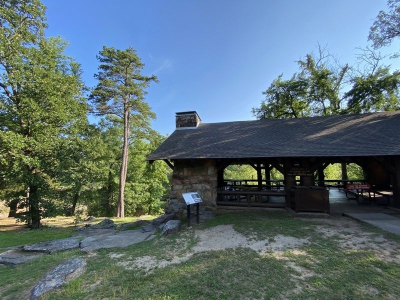
As you explore these unique structures around Petit Jean State Park,
you will find that nature and history are strongly connected here.
Rock House Cave - Explore this sandstone
bluff shelter and look for ancient Native
American . . . — — Map (db m233679) HM
Company V-1781 was the
designation of Petit Jean's CCC.
camp. The "V" indicated the
company employed World War I
veterans. The situation was
relatively unique: only 10 percent
of CCC camps around the United
States were veteran camps. . . . — — Map (db m233675) HM
Formed over eons, this inspiring landscape offers us a sense of wonder.
The landscape of Petit Jean State Park reveals a
story of stone, weather, and time.
Much of Petit Jean's exceptional landscape results from
earthen rock . . . — — Map (db m233687) HM
Exploring the geologic story here connects you with Petit Jean Mountain
Lepidodendron
One of the dominant tree-like plants of
either the Carboniferous Period (359-299
million years ago) or the late
Pennsylvanian Period (323-299 . . . — — Map (db m233678) HM
Following the stock market
crash of 1929, the United States
plunged into the depths of the
Great Depression. By 1932, the
unemployment rate was a
staggering 23%. Over 13 million
Americans had lost their jobs.
In a landslide victory, . . . — — Map (db m233673) HM
206th Coast Artillery Killed in Action
WW II
Kenneth Burkhart
Clifford Cloud
Joseph J. Eble
John H. Franklin
Charles Hutton
Cletis Jeffers
Fred Johnson
James Lemmer
Owen “H” Lynch
Carl Neal
Roy Shreevo
Frank Sweeney . . . — — Map (db m227350) WM
On this site stood the Blessed Sacrament Catholic Church, consecrated October 17, 1933, by the Reverend John Morris, Bishop of Little Rock. This Romanesque Revival building was built with the help of parishioners to replace the previous church, . . . — — Map (db m206942) HM
On June 17th 1862, the First Wisconsin Cavalry, US saw action against 30th Ark Inf. and 6th MO Militia CSA. The overall commanders were Confederate General M. Jeff Thompson and US Colonel Edward Daniels. Federal forces bivouacked at Jonesboro . . . — — Map (db m221048) HM
The site of Jonesboro was laid off as the county seat of Craighead County in 1859, and there was erected soon afterwards the first court house in the county. — — Map (db m116609) HM
February 1, 1878 - December 22, 1950
Tennessee Native -Arkansas Daughter
A good southern wife in the traditional sense.
First:
Elected woman U. S. Senator
Woman to preside over the Senate
Woman chairman of a Senate committee . . . — — Map (db m227550) HM
The last Confederate veteran living in Arkansas, William Murphy Loudermilk, is buried here in Keller’s Chapel Cemetery. Private Loudermilk, who was born Oct. 17, 1847, joined a North Carolina regiment in the Army of Tennessee at age 16 and fought at . . . — — Map (db m116195) HM
LTC Teddy W. Pylant
US Army - Retired
Founder/President CCVMF
LTC Ted Pylant, a Vietnam veteran, served 34
years in the Arkansas National Guard as a
member of the 875th Engineer Battalion.
He also served at the Arkansas National
Guard . . . — — Map (db m227423) HM WM
This is the 16,000 pound anchor off the bow of the nuclear powered guided missile cruiser USS Arkansas, CGN-41. This anchor was placed here in grateful memory of those who served aboard her. Four ships of the United States Navy and one of the . . . — — Map (db m116687) HM
The Battle of Jonesboro took place at the Craighead County Court House in Jonesboro, Arkansas, on August 2, 1862. Company I, 30th Arkansas Infantry of the Fifth Trans-Mississippi Confederate army, under the command of Captain Mitchel A. Adair, . . . — — Map (db m116608) HM
To the 1385 sons of Craighead County who during the World War served their Country on land and sea and well maintained its highest ideals and traditions. This monument is erected by their fellow citizens as testimonial of gratitude and affection. . . . — — Map (db m227276) WM
Several companies were raised in Craighead County for the Confederate army. Co. I of the 13th Arkansas Infantry – the “Confederate Grays” – formed in 1861. A company of the 23rd Arkansas Infantry and Co. I of the 30th . . . — — Map (db m116186) HM
In this small log building Albert Pike noted lawyer, poet and mason taught school in 1832. He later went to Little Rock to become editor of the Advocate. — — Map (db m96857) HM
Camp Jesse Turner, located on Pickett Hill on the east side
of Van Buren (Crawford County), was a small, specialized
railroad training camp for soldiers to learn to operate
railroads captured in enemy territory, worldwide, during
World War II. . . . — — Map (db m244063) HM
The companies of soldiers that came out
of Van Buren were formed at this historic
landmark. It is also the site where some
infantry and Calvary units camped and
drilled. There were nine different
companies that were formed in . . . — — Map (db m96864) HM
[Northwest face]
1899
Furled but not forgotten
1861 C.S.A. 1865
Erected by the Mary Lee Chapter
United Daughters of the Confederacy
[Southwest face]
Battles
Oak Hill – Aug. 10, 1861.
Elk Horn – March 6 to 8, 1862. . . . — — Map (db m236850) WM
Remember those who served
and those who died
Killed in Action
Maj. Walter Hugh Moon
Capt. Jimmy Cartwright
LCpl. Roger Dale Cecil
LCpl. Billy Dale Livingston
SSgt. Samuel Ray Nixon
PFC. Jewel Lee Rainwater
GMG1 Arthur C. . . . — — Map (db m100703) WM
On this lawn
was erected our first
Courthouse in 1841 and
has been the scene for many
events during the wars
in which Crawford County boys fought.
Mexican War, 1846.
War Between the States, 1861-1865.
Spanish American War, 1898. . . . — — Map (db m96859) WM
Using advanced technology to understand the past.
Like the methods of Crime Scene Investigators, science provides a variety of ways to look beneath the surface of the Drennen House grounds for evidence of the past. Techniques like . . . — — Map (db m120491) HM
The Battle of Prairie Grove was a grim moment for the Confederate Army. This conflict severed all chances for the South to use Northwest Arkansas as a route to invade Missouri. The shattered and defeated soldiers retreated from Prairie Grove to Van . . . — — Map (db m96617) HM WM
Erected in memory of
our Confederate soldiers
from Ark., Tex., La., Mo., and
Indian territory,
who lost their lives in the
Battles of Oak Hill, Elk Horn,
and Prairie Grove. — — Map (db m96632) WM
In memory of
Merle D. Hay
Thomas Enwright
James B. Gresham
They were the first members of
the Expeditionary Army of the
United States in France to die
that we might live
stricken on the field of glory,
November 3, . . . — — Map (db m96633) WM
Freedom of Speech • Freedom of Worship
Freedom from Want • Freedom from Fear
This park, "Freedom Park" embodies the spirit of "Four Freedoms" by Norman Rockwell. Elements of the park were designed to reflect each of the Freedoms. The . . . — — Map (db m244099) HM
GFWC Women's League of Van Buren
Proudly Dedicates this Clock as a Symbol of our Appreciation to all Veterans.
May it Stand to Honor all the Men and Women of the Military who have Bravely Served
and their Families who have Sacrificed so . . . — — Map (db m244105) WM
There is no doubt that other structures,
demolished at some point in the family's history,
stood on the Drennen-Scott property.
Like many wealthy 19th-century households, this one had privies, a well, smokehouse, carriage house, . . . — — Map (db m120515) HM
Hebe, Greek goddess of youth and happiness was placed in her fountain on the Crawford County Courthouse lawn in 1908 by the Women's Village Improvement Society.
Repairs were made to both Hebe and fountain in memory of Robert Benham who served . . . — — Map (db m97670) HM
The residents of Log Town were witness to the retreat of the Rebel army through Van Buren and onward through their settlement. High on Log Town Hill the community watched as masses of Southern soldiers crowded the hill trying desperately to reach . . . — — Map (db m96614) HM
From the front of his home, John Drennen could overlook the bustling port town of Van Buren, including the wharf originally known as Phillips Landing.
Until after the Civil War, the Arkansas River and the steamboats that plied its . . . — — Map (db m120427) HM
The Butterfield stage route
between Saint Louis and San
Francisco passed through the
main street of Van Buren,
Arkansas and crossed the
river at this point.
— — Map (db m96457) HM
Brig. General Francis J. Herron
Herron was Blunt's aggressive and bold subordinate, "they
cooperate well, and handle the rebels without gloves," declared
a Union officer. He led the Second and Third (Missouri) Divisions,
and was ready . . . — — Map (db m243979) HM
This active and restored railroad depot, completed
around 1902 by the Frisco Railroad Company, stands
as a living memorial to the entrepreneurial spirit and
the great periods of commerce that railroads brought
to our city.
As early as . . . — — Map (db m243970) HM
By a natural turn in the Arkansas River, Van Buren began at
the water's edge in 1818, straight down this hill. So, the first
muddy trail from the river came directly and in directly to this
spot - and became the hub of activity for Van Buren and . . . — — Map (db m243972) HM
The Blue Star Service Flag
The Blue Star Service Flag became a symbol of pride, honor and
service for families during World War I. Each blue star represented
a member of their family who was serving in the armed forces and
the . . . — — Map (db m244103) HM
Sunday, December 28, 1862
The day started like any other cold December Sunday, by nightfall, Van Buren's citizens would know everything had changed. The Civil War had come home.
As they came out of church and made their way toward home . . . — — Map (db m243975) HM
After the Dec. 7, 1862, Battle of Prairie Grove, the Union Frontier Division set out to strike Confederate forces on the Arkansas River. On Dec. 27, 8,000 Union troops headed south through the Boston Mountains. They hit Van Buren on Dec. 28 and . . . — — Map (db m119954) HM
The military history of the United States spans a period of more than two centuries. During these years, the United States evolved from a new nation fighting Great Britain for independence (1775-1783), through the monumental American Civil War . . . — — Map (db m244110) HM WM
John Drennen made profitable choices during his diverse professional life as merchant, bank trustee, plantation owner, and Indian agent.
He linked his future to the fledgling town of Van Buren, and built his family home here, . . . — — Map (db m120426) HM
Named for Adolphus Fountain
Crawford
Born Aug. 15, 1848
Died Feb. 21, 1876
Confederate soldier of Arkansas,
he fought under Gen. Price. — — Map (db m116177) HM
The Cherokee came from East Tennessee and North Carolina area. General Sam Houston was Governor of Tennessee until he resigned and joined the Cherokees in the Indian Territory, now Oklahoma. His wife Talahina, was the daughter of the Cherokee chief . . . — — Map (db m234420) HM
The next two (2) miles is a part of Military Road used in transporting Indians to Oklahoma Territory between 1832 and 1841. From a group of 16,000 Cherokees, 4,000 died enroute. Other tribes to move West were Chickasaw and Choctaw. The great war . . . — — Map (db m234419) HM
This granite marker on the south lawn was erected by Crittenden County United Daughters of the Confederacy, and dedicated October 4, 1936, as a memorial to those who served with Confederate military during the War Between the States. The magnolia . . . — — Map (db m116781) HM
The Crittenden Bank & Trust, the town’s third bank, began operation January 9, 1909, replacing the Bank of Marion which had failed in 1908. Three other short-lived banks were housed in this building. The last banking operation here was that of . . . — — Map (db m116727) HM
The Health Department, dedicated May 4, 1938, was built with funds by the Federal Works Progress Administration (WPA). When additional space was needed, the Crittenden County Negro Business Men's League, led by George Walker, Jr. and John Gammon, . . . — — Map (db m116780) HM
Dedicated to all veterans of Crittenden County
To the men and women who served their country in war and peace with honor
We shall not forget — — Map (db m234719) WM
In 1673, another European expedition arrived in Arkansas. Canoeing down the Mississippi River from the Illinois country (the upper Mississippi River Valley), Father Jacques Marquette, Jesuit missionary, and Louis Joliet, a coureur de bois . . . — — Map (db m234417) HM
The original Delta was a land of enormous stands of oak, gum, cottonwood, hickory, pecan, elm, pine and cypress, some of which had stood for perhaps 500 years. Cypress and tupelo could be found in the bottoms, along with water-tolerant oaks, . . . — — Map (db m234414) HM
On June 18, 1541, Hernando de Soto's Spanish expeditionary force crossed the Mississippi River and became the first Europeans to enter Arkansas. For the next two years, the Spaniards explored through Arkansas with a large number of captive Indians. . . . — — Map (db m234415) HM
Woolfolk is author of The History of Marion and History of Crittenden County, an award-winning newspaper editor, graduated from Memphis State Law School in 1985 at the age of 68, entered into private practice, and served as Marion . . . — — Map (db m116783) HM
Originally, the first floor had eight
classrooms and the upper floor housed
the auditorium. The ground-level
basement housed only the furnace room
and restrooms until 1928 when part of
the basement was also used for the
school's first . . . — — Map (db m221334) HM
Designed and built by Major Moore for Thomas Koser, the building was completed December of 1911. The building, which is constructed of native hardwoods, brick and concrete, had pressed tin ceilings and hardwood floors. The hotel had its own water . . . — — Map (db m116726) HM
When classrooms were carved out of the second floor auditorium space in the first high school. Marion students and the entire community used a tabernacle built in 1924 on the south side of the high school for events requiring an auditorium. When the . . . — — Map (db m116777) HM
May 10, 1869, a petition was submitted the county court for established of School District No. One the Marion district. The formation of the district was approved by the circuit superintendent of public schools. The school operated by the original . . . — — Map (db m116779) HM
First Highway constructed in Arkansas, Hopefield
to Little Rock, extended to Fort Smith and into Indian Territory, (Oklahoma). Built by the United States under supervision of the Quartermasters Department of the United States Army. Survey was . . . — — Map (db m116549) HM
This fourth County Jail building was originally a two-story brick framed structure. Some of its hardware and cell materials were used in the construction of the 1911 jail built west of the courthouse. Abandoned and vacant from 1919, it was purchased . . . — — Map (db m234418) HM
One of the city's biggest fires occurred
in the early 1900's when a series of
businesses in frame buildings on the
east side of Court Street were destroyed
by fire. Volunteer firefighters brought
water from Harvard yards by train to
help . . . — — Map (db m116545) HM
On April 27, 1865, the steamboat Sultana exploded on the Mississippi River. She was heading north, dangerously overloaded with some 2,200 passengers, most of them freed Union prisoners of war from the Andersonville and Cahaba camps. A . . . — — Map (db m116352) HM
Early on April 27, 1865, the overcrowded steamboat Sultana exploded on the Mississippi River near Marion, Arkansas. The vast majority of the Sultana's passengers, believed to number over 2000, were Federal soldiers, recently released . . . — — Map (db m116356) HM
News of the assassination of Abraham Lincoln on April 14, 1865 overshadowed the tragedy of the Sultana, which happened two weeks later.
The actual number of casualties from the SS Sultana is unknown, but some estimates are as high as 1,800. . . . — — Map (db m242015) HM
In 1831, a group of Native Americans collectively referred to as the Five Civilized Tribes: the Cherokee, Chickasaw, Choctaw, Muscogee, and Seminole, were living as autonomous nations in what would be later called the American Deep South. The . . . — — Map (db m234416) HM
In North America, the Indians
were building mounds such as
these from before the time
of Christ until after DeSoto
explored this area. These are
believed to be villages of
the Aquixo or Pacaha, 1541. — — Map (db m221347) HM
The inaugural broadcast of West Memphis' KWEM radio station on February 23, 1947, set the stage for what would become one of the pioneering platforms for Delta blues and the beginnings of the rock 'n' roll sound.
Here at 231 Broadway Boulevard in . . . — — Map (db m221358) HM
An old river town, once located on the banks of the Mississippi River, deriving its name from Indian mounds. Federal troops burned it January 15, 1863. — — Map (db m221342) HM
In 1943, Morris Berger opened his legendary Plantation Inn
nightclub on this site in a former West Memphis gambling hall.
Billed as having the largest dance floor in the South, it became an
electrifying live-music destination for the region until . . . — — Map (db m221350) HM
The Ott family of Parkin purchased the
Northern Ohio School from the Kelly family in
1959. The Kellys had been using the school
for a hay barn. The Ott family transformed
the old "barn" into a home by portioning
rooms and designing a living . . . — — Map (db m221318) HM
Step into the school gently. It's filled with history
and memories … maybe some from your school days.
As you enter the school you will see the
classroom as it was on any given school day
between 1936 and 1948. The school was . . . — — Map (db m221320) HM
Much of what is known about the Northern
Ohio School came from first-hand accounts
known as oral histories. People interviewed
were former students, teachers, children of
the sawmill owners and workers, persons who
lived in Sawdust Hill, or . . . — — Map (db m221319) HM
The legacy of the Mississippian culture lives forever through the Three Sisters Garden, like the one you see planted here.
The American Indians who lived here over 500 years ago were expert farmers whose most important crops were corn, beans, . . . — — Map (db m116605) HM
Welcome to Northeast Arkansas Pick up your Discovery our guide in the part visitor for center.
From pre-history to today, people have come here for a variety of reasons. Settlers found a state rich in wildlife and wilderness. Ancient . . . — — Map (db m232112) HM
Ongoing warfare with other
Native American groups
led villagers to construct a
defensive ditch around their
town. The depression before
you was a formidable obstacle
to anyone trying to attack. You
will cross this ditch several
more times . . . — — Map (db m231813) HM
As northern timberlands were depleted,
timber buyers looked to the dense forests in
the south. In March 1902, S.W. Sterling, a
timber buyer for a firm in Grafton, Ohio,
was buying timber in Missouri when he
heard about the fine timber at . . . — — Map (db m221310) HM
Rural education in the Delta was no easy task
for students or teachers. There were many
obstacles to overcome, such as weather,
walking distances, and family responsibilities.
Plus, being an African-American school,
students and teachers were . . . — — Map (db m221316) HM
Daily lessons revolved around the "three R's:"
reading, writing and arithmetic. The Child's
World Reader, a basic math book, and a
speller were the textbooks used.
Class was in session from 8AM through 3PM
except in September and . . . — — Map (db m221317) HM
The flood of 1912 was the greatest disaster ever suffered by Parkin. Breaks in the St. Francis and Mississippi levees covered the land and into our homes from 4 to 30 feet in depth in April and part remained until summer. Most of the people fled to . . . — — Map (db m234421) HM
Around 1900, there were about 16 one-room
schoolhouses in and around Parkin. Most
were on plantations for the education of the
sharecroppers' and farm workers' children.
The Northern Ohio School, built around 1910,
was no different. The school . . . — — Map (db m221314) HM
The Parkin
archeological site was
preserved better than
most because it was
reoccupied during most of the 20th century. The residents who lived on the ancient
village site.
in the 1900s came to
call their neighborhood
Sawdust Hill or . . . — — Map (db m231817) HM
As the Northern Ohio Cooperage and Lumber
Company expanded, so did the need for housing and
services for its workers. Out of this came the Sawdust
Hill community. At its peak, over 60 structures,
including shotgun-style houses, a Baptist church, . . . — — Map (db m221309) HM
Arkansas experienced a number of economic
advances in the first quarter of the 20th
Century. Extensive railroad building in the
late 1800s set the stage for economic growth.
Although the Delta's popular economic image
is King Cotton, . . . — — Map (db m221313) HM
In 1541 Chief Casqui
greeted Hernando
de Soto not far from.
where you are standing.
This trail highlights the unique
history of the archeological site.
The fully accessible 1/4 mile trail
will take you approximately 30
minutes to walk. . . . — — Map (db m233181) HM
After Arkansas seceded from the Union in May 1861, Confederate officers began to recruit in the Wittsburg area. Companies B, D, F and K of the 5th Arkansas Infantry Regiment were organized at Wittsburg June 12-14, 1861. David Cross, for whom Cross . . . — — Map (db m116179) HM
The county was named for Col. David C. Cross. First seat of justice, Cleburne 1865. Moved to Wittsburg 1865 where it remained until 1884 when it was removed to Vanndale and later in 1903 the county seat was established at Wynne, where it has since . . . — — Map (db m158125) HM
Down the trail from where you are standing is the most well-preserved remaining section of the historic Trail of Tears in Arkansas.
Tradition and heritage run deep jn the collective souls of the Five Southeastern Tribes (Choctaw, Chickasaw, . . . — — Map (db m142034) HM
Road to Marks' Mills
Gen. Frederick Steele’s Union army set out from Little Rock on March 23, 1864, to join a second army in Louisiana and invade Texas. He made it as far as modern-day Prescott before turning toward Camden in hopes of . . . — — Map (db m121222) HM
Front
Gen. Frederick Steele’s Union army left Camden on April 26, 1864, starting a retreat to Little Rock. Confederate pursuers caught up with them on April 29 on the Jenkins’ Ferry Road and began skirmishing. Union gunners of the 2nd . . . — — Map (db m121168) HM
Arkansas Military Institute
The state legislature chartered the Arkansas Military Institute in 1850, and the school was built on Chapel Ridge in Tulip. Cadets had to be over 14 and at least 4 feet 9 inches tall. Classes included Latin, . . . — — Map (db m121218) HM