On Mitchell Hill Road at Tom Wallace Park Road, on the right when traveling south on Mitchell Hill Road.
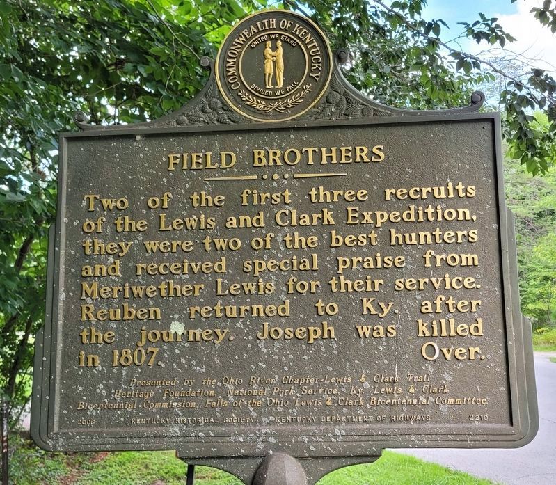
Joseph and Reuben Field were two of the most important members of the 1803-1806 Lewis and Clark Expedition to the Pacific Ocean. Born in Virginia, they were raised in the present Okolona, Fairdale, and Valley Station areas. Over. Reverse . . . — — Map (db m204268) HM
On Brownsboro Road (U.S. 42) at Blankenbaker Lane, on the right when traveling west on Brownsboro Road.
Home of Gen. George Rogers Clark from 1809 until his death, 1818. Built by William and Lucy Clark Croghan about 1790. Visited by Presidents Monroe, Jackson, Taylor. Clark and his 175 frontiersmen defeated British-Indians during Revolution: won . . . — — Map (db m161987) HM
On Taylorsville Road (State Road 155) south of Six Mile Lane, on the right when traveling south.
The first Lutherans in and around Brunerstown, now Jeffersontown, were early settlers from Va., Md., Pa., and N.C. Samuel Mau, licensed to preach in Kentucky in 1789, served German-speaking churches in Jeffersontown, Nelson County, and Danville . . . — — Map (db m161800) HM
On Watterson Trail at College Drive, on the right when traveling north on Watterson Trail.
Conrad-Seaton House
Constructed in 3 phases, the oldest part of this Federal style house was built by Valentine Conrad in 1803. Ca. 1805-10, a two-story addition with two chimneys was built. In 1844, John & Mary Hikes Seaton bought the . . . — — Map (db m161799) HM
On Taylorsville Road (State Road 155) south of Watterson Trail, on the right when traveling north.
Roscoe Goose, 1891-1971, rode the 1913 Derby Winner Donerail, which paid biggest odds in Derby history. Born near here, Goose became a trainer and aided many jockeys. Active in all aspects of racing. One of first 10 men named to Ky. Athletic Hall of . . . — — Map (db m161796) HM
Near Bashford Manor Lane, 0.1 miles west of Bardstown Road (U.S. 31E), on the left when traveling west.
Alonzo "Lonnie" Clayton
Born in Kansas City, Mo. in 1876, he followed his brother into the riding profession. At age 12, he went to Chicago to become an exercise rider. With his first win in 1891, he came to Louisville to ride for Bashford . . . — — Map (db m162005) HM
Nicola Marschall designed the Stars and Bars, official flag of Confederacy, and gray uniform of the Southern army, March 1861. Born, 1829, St. Wendel, Germany, he came to U.S. (Alabama) in 1849 to continue professionally in art. Noted portraits: . . . — — Map (db m161302) HM
On La Grange Road (State Road 146) at Heafer Road, on the right when traveling north on La Grange Road.
This eastern Jefferson County community began with five acres purchased in 1874 by Alfred Berry, a freedman. Other Berrytown founders were Wm. Butler, Sallie Carter, and Kidd Williams, all of whom bought land from Samuel L. Nock, a wealthy . . . — — Map (db m161778) HM
On Berrytown Road at Woodbrook Court, on the right when traveling east on Berrytown Road.
This cemetery became focal point for the Berrytown community, which began when Alfred Berry purchased five acres in 1874. Berrytown Cem. was purchased on June 23, 1890, by United Brothers of Friendship Lodge No. 83. As trustees, Lodge members . . . — — Map (db m161779) HM
On Bardstown Road (U.S. 150) 0.1 miles north of Brentlinger Lane, on the right when traveling north.
First named Chenoweth Run, church formally organized June 16, 1792, about 12 mi. S. E. of Louisville. Log church built 1798 on land given by William Fleming to Moses Tyler, trustee. Moved to this community after changing name to Cedar Creek, 1846. . . . — — Map (db m174480) HM
On Rudy Lane, 0.1 miles south of Brownsboro Road, on the right when traveling south.
(obverse) Early in 1792, Revolutionary War veteran, Richard Taylor, bought 175 acres bounded by Rudy Lane. Land was given to Isaac Shelby for his father's Colonial Wars service. Here Taylor built a brick house, which he sold to George Rudy in late . . . — — Map (db m133910) HM
On Lime Kiln Lane north of U.S. 42, on the right when traveling north.
The Temple was created in 1976 by uniting Reform congregations Adath Israel and Brith Sholom. Adath Israel was chartered by Kentucky in 1842; it was the oldest Jewish congregation in Ky., 7th Reform in U.S., a founder of Union of American Hebrew . . . — — Map (db m161986) HM
For most of the 19th century this house was center of prosperous Ohio River farm with an active riverboat landing. Built circa 1837 by Gabriel Farnsley (1800-1849). House and 200-acre farm site purchased, 1862, by Alanson Moremen (1803-90). . . . — — Map (db m161672) HM
On Algonquin Parkway east of Gibson Lane, on the right when traveling east.
Here was westernmost fort of 11-fort system designed to protect Louisville from the Confederates during Civil War. Construction began August 1, 1864; almost complete by war's end. Funded by the city and the federal government, Fort Southworth, . . . — — Map (db m202273) HM
Side 1 After fall of Ruddle's and Martin's stations, Clark led expeditions against Indians in 1780 and 1782. In later years Clark was plagued by poor health and war debts incurred for his country. He died at Locust Grove, his sister's home. . . . — — Map (db m100711) HM WM
George Rogers Clark At Locust Grove
George Rogers Clark moved to Locust Grove in 1809 following amputation of his right leg. He lived here with his sister Lucy and her husband William Croghan until Clark's death in 1818. Clark recognized by . . . — — Map (db m101463) HM
On Cave Hill Road, on the right when traveling east.
Lawyer, legislator, soldier, and governor, he was born on Jan. 3, 1817, in present Clinton County. During Civil War he raised and was colonel of 3rd Ky. Union Inf. In 1862, Pres. Lincoln appointed him US Dist. Attorney for Ky. The next year he . . . — — Map (db m161301) HM
On Lucas Lane east of Cave Spring Place, on the right when traveling west.
Isaac Hite's Home
This log house, which appears as Hite's house on John Filson's map printed in 1784, was on the plantation, Cave Spring, owned by Isaac Hite, an early surveyor. Hite (1753-1794) was born in Virginia. He came to Kentucky in . . . — — Map (db m161776) HM
On Poplar Avenue, 0.1 miles east of Cave Hill Road, on the right when traveling east.
This statesman and entrepreneur fostered Louisville's growth from small town in 1810 to nation's 10th largest city in 1850. Promoted building of Portland Canal and the first R.R. bridge over Ohio River. As president of the University . . . — — Map (db m161205) HM
On Dixie Highway (U.S. 60) at Depot Lane, on the right when traveling north on Dixie Highway.
Company town of Kentucky’s only Portland cement manufacturer. Philadelphia industrialist Samuel Horner Jr. developed housing for white and black workers of his Kosmos Portland Cement Co. in rural Jefferson County. A rail station, post office, . . . — — Map (db m161670) HM
In 1873, the fourth Kentucky state mental hospital was established here. From a single brick building housing 370 patients, grew a campus of 15 buildings and 5000 patients, including a working farm & orchards. Buildings constructed in Tudor and . . . — — Map (db m161780) HM
On Breckenridge Lane (State Road 1932) south of Hillsboro Road, on the right when traveling south.
Lewis and Clark in Kentucky. Charles Floyd (ca. 1782-1804).
Born at or near Floyd's Station in present St. Matthews. In August 1803 Floyd joined the Lewis and Clark Expedition. He was appointed a sergeant in Corps of Discovery . . . — — Map (db m161998) HM
On Shelbyville Road (U.S. 60) 0.2 miles east of Moser Road, on the right when traveling east.
Two largest skirmishes of Civil War in Jefferson County occurred here Sept. 27 and 30, 1862. CSA forces, already in control of the State Capital, were threatening Louisville. In first clash the Confederates were driven back to Floyds Fork. Three . . . — — Map (db m26316) HM
On Stonestreet Road, on the right when traveling north.
Born in Jefferson Co., Stonestreet was the first woman to be elected superintendent of Jefferson Co. schools. An 1877 graduate of Nazareth Academy, she became a teacher in 1889. In 1897 she was elected superintendent by 845 votes, defeating two men. . . . — — Map (db m161669) HM
On St. Anthony Church Road at Rica Road, on the right when traveling south on St. Anthony Church Road.
St. Andrew's Catholic Church
On this site in 1848-51, one of the first rural Catholic churches in Jefferson County was built on Cardinal Hill by German and French immigrants. It was on 1.3 acres donated to the Archdiocese of Louisville by . . . — — Map (db m161574) HM
On Shelbyville Road (U.S. 60) at Christian Way, on the right when traveling east on Shelbyville Road.
Named for Peter A'Sturgus, early Kentucky pioneer, who settled on 2,000-acre tract of land surveyed, 1774, and granted to Col. William Christian by patent dated June 2, 1780. One of the five important pioneer stations on Middle Fork of Beargrass . . . — — Map (db m203184) HM
On Taylorsville Road (State Road 155) at Tucker Station Road, on the right when traveling west on Taylorsville Road.
By 1785, Edward Tyler patented some 1,000 acres on Chenoweth Run. Sons Moses, William, Edward III, and nephew Robert Tyler established farms on this land, each productive and self sufficient by the 1790s, forming a rural community. The three . . . — — Map (db m161794) HM
On Zorn Avenue at River Road, on the right when traveling north on Zorn Avenue.
~Front~ Louisville Water Co. incorporated in 1854. Its first pumping station, in Classical Revival style, blends beauty and utility. The classic structures were designed and built by Theodore R. Scowden and his assistant, Charles Hermany. . . . — — Map (db m71979) HM
On St. Andrews Church Road, on the right when traveling east.
Wisertown
Area once known as Wisertown. Descendants and extended family of John (1793-1877) and Luzanna Wiser(1804-1873) lived here, including Gagels, Arnolds, and Webers. John came here 1817, married Luzanna 1821, bought farm 1838. They . . . — — Map (db m161573) HM
Col. Richard Taylor of Va., veteran of French and Indian War and the Revolution, built original part of "Springfield" ca. 1790. Boyhood home of son "Old Rough and Ready" Zachary Taylor (1784-1850), veteran of 1812 and Black Hawk wars. Mex. War hero . . . — — Map (db m100859) HM
On Brownsboro Road (U.S. 42), on the right when traveling west.
Gen. Zachary Taylor (1784 – 1850), distinguished lifelong soldier and twelfth President of the United States, buried here in family cemetery. Commissioned Lt. in 1808. Served in War of 1812; Black Hawk War, 1832; Seminole War, 1836 – 43. . . . — — Map (db m21405) HM
On 3rd Street Road (State Road 907) north of Auburn Place Drive, on the left when traveling south.
Fenley Family
By 1841, John H. Fenley owned an 1,100 acre farm south of Louisville. His son Isaac inherited the property and, by 1858, it was known as Hickory Grove. Isaac was a botanist, who had several orchards. The Fenley apple originated . . . — — Map (db m161572) HM
On Audubon Parkway at Robin Road, on the right when traveling east on Audubon Parkway.
City of Audubon Park
The city was built on land granted to Col. William Preston in 1773 for service in French and Indian War. Its residential development (1912-45) proceeded from Audubon Country Club's incorporation, 1908. Credit is given to . . . — — Map (db m161326) HM
Near Bashford Manor Lane at Donard Park Avenue, on the left when traveling west.
Designed for J. B. Wilder by Henry Whitestone, the residence was built in 1874. Wilder named Bashford Manor after an ancestral home in Maryland. In 1887 George J. Long purchased the farm and turned it into a nationally known racing stable. It was . . . — — Map (db m162006) HM
On Southside Drive (State Road 1020) at West Kenwood Way, on the left when traveling south on Southside Drive.
Developed and owned by Col. Jim Douglas, it opened in 1895 as a trotting track. Directly competed with Churchill Downs after 1906, when it changed to a Thoroughbred racing venue. Track drew national praise, from 1912-18, as home of the renowned . . . — — Map (db m161566) HM
On Dundee Road at Trough Spring Lane, on the right when traveling south on Dundee Road.
Lewis and Clark in Kentucky Trough Spring
While on the Corps of Discovery's expedition to the Pacific Ocean, coleader William Clark wrote six letters to his brother Jonathan at Trough Spring. In 1805 he sent over 30 expedition artifacts here . . . — — Map (db m162011) HM
On Medford Lane at Bashford Manor Lane, on the right when traveling north on Medford Lane.
Bray Place
Major Samuel Bray surveyed here in 1779 & returned with his family in 1796. He built original two-story house ca. 1800. Bray served in the Ky. legislature in 1820. In 1851, former slaves Henry & Eliza Tevis bought 40 acres from . . . — — Map (db m162007) HM
On Gast Boulevard just north of Dutchmans Lane, on the right when traveling north.
Much of the early aviation history in Louisville is the result of the Aero Club of Louisville. Founding fathers included pilots returning from WWI & businessmen who saw the potential of aviation beyond military applications. A. H. Bowman, Sidney . . . — — Map (db m142853) HM
Near Taylorsville Road (State Road 155), on the right when traveling west.
Kentucky's oldest civil airport was first used in 1919. Army Air Corps Reserve unit established three years later. Double hangars (west) housed 325th Observation Squadron. Terminal building, erected in 1929, was used by airlines through 1947. . . . — — Map (db m162001) HM
On Sidney Park Drive west of Cannons Lane, on the right when traveling west.
The east side of Bowman Field airport was expanded in 1940 to become the Bowman Field Air Base. It was a training facility with 124 buildings used by the U.S. Army Air Force throughout World War II. One hangar survives. Bowman Field was first used . . . — — Map (db m161999) HM
On Dutchmans Lane at Cannons Lane, on the right when traveling east on Dutchmans Lane.
Rebecca Rosenthal Judah
1866-1932
Rebecca Rosenthal Judah organized the National Council of Jewish Women, Louisville Section, and served as their president from 1896 to 1910. She worked to win women's right to vote and was also vice . . . — — Map (db m162000) HM
On Rebel Road north of Brownsboro Road (U.S. 42), on the left when traveling north.
On June 17, 1835, the daughter of Zachary Taylor, Sarah Knox, married Jefferson Davis in the house that originally stood on this site. The home was owned by Zachary Taylor's sister. Soon after their marriage, while visiting Davis' relatives in . . . — — Map (db m161990) HM
On Frankfort Avenue (U.S. 60) at Blue Horse Avenue, on the right when traveling west on Frankfort Avenue.
Col. Frederick Geiger
In 1796, Revolutionary War veteran Frederick Geiger came to Jefferson Co. from Md. Settled in Butchertown in 1807. He raised a company of Ky. Mounted Riflemen for Gen. W. H. Harrison's 1811 Indian Campaign. Wounded at . . . — — Map (db m161156) HM
Earl McDonald (1885-1949) helped establish Louisville as the home of jug band music. An accomplished jug blower, vocalist, composer, leader, & recording artist. Bands in Australia, Europe, and Japan continue to admire, perform, and emulate his 42 . . . — — Map (db m161166) HM
On East Washington Street, on the right when traveling east.
Parish established in 1866 by Bishop Martin J. Spalding to serve the German and Irish Catholics in Butchertown. Reverend Leopold Walterspiel appointed to organize congregation under the patronage of St. Joseph. The present church was dedicated in . . . — — Map (db m161179) HM
On E Washington Street at N Shelby Street, on the right when traveling west on E Washington Street.
Edison (1847-1931) rented a room in this house. As a young man he conducted experiments, often all night, then walked to his job as a telegraph operator at 58 West Main Street. Experimenting at work, he spilled acid and was fired. He left Louisville . . . — — Map (db m104469) HM
On West Broadway (U.S. 60) at South 10th Street, on the right when traveling east on West Broadway.
Louisville and Nashville Railroad
Chartered by the Kentucky General Assembly March 5, 1850. First track was laid near here
in July 1855. First train ran in August. 1855. First passenger station dedicated at 9th and Broadway in 1858. From it . . . — — Map (db m161252) HM
On Poplar Level Road (State Road 864) south of Mercer Avenue, on the right when traveling south.
Near this site at Taylor Ave. and Poplar Level Rd. was headquarters of Camp Zachary Taylor. The WWI training camp named for President Zachary Taylor became one of 16 national army camps in the U.S. Begun in June 1917 and built in 90 days on 2,730 . . . — — Map (db m161325) HM
On Cherokee Parkway at Everett Avenue, on the right when traveling north on Cherokee Parkway.
Highland Mothers Club
Founded by Mary K. Lee and the mothers of her Highlands students. They began meeting in their homes, & later at Douglas Blvd. Christian Church, before first local PTAs were organized. They studied and educated each . . . — — Map (db m161753) HM
On Cherokee Road at Cherokee Parkway, on the right when traveling south on Cherokee Road.
The founding of this Legion dates to 1837, when a company was formed as the "Louisville Guards." The next year three more companies were organized. They were the "Washington Guards," "Kentucky Riflemen," and "Louisville Grays." These military . . . — — Map (db m161755) HM
She served as the first Episcopal Deaconess in charge of the Home of the Innocents from 1880 until her retirement in 1904. She oversaw the baptisms of 284 infants and developed & administered the first kindergarten at the Home in 1888. She retired . . . — — Map (db m161419) HM
On Cherokee Road at Cherokee Park Road on Cherokee Road.
Enid Yandell (1869-1934)
Challenged the role of women in the art world as a renowned sculptor. Born 1869 in Louisville and graduated Cinn. Art Acad. in 1899. Gained prominence sculpting caryatids for Woman's Building at 1893 World's Columbian . . . — — Map (db m101765) HM
On Virginia Avenue at Interstate 264, on the left when traveling west on Virginia Avenue.
Located west of 32nd and south of Garland Ave., "Little Africa" was original African American section of Parkland. Settled in 1870s, African Americans first called it "Needmore." "Little Africa" evolved from a shantytown into a thriving community by . . . — — Map (db m161683) HM
On West Broadway west of South 32nd Street, on the left when traveling west.
Carl Braden Memorial Center
Carl and Anne Braden were committed to bringing together people of color and white people to work for social and racial justice. National figures such as Dick Gregory, Angela Davis, Jesse Jackson, and Pete Seeger . . . — — Map (db m161250) HM
On Virginia Avenue west of Kaiser Court, on the right when traveling west.
Home of Anne & Carl Braden
4403 Virginia was longtime home of Anne and Carl Braden, early white allies of the southern civil rights movement. Segregationists marched here in 1954 after the couple helped an African American family desegregate . . . — — Map (db m161685) HM
On Grand Avenue, on the right when traveling east.
Muhammad Ali's Home Site
Cassius Marcellus Clay, Jr. was born on January 17, 1942 at Louisville General Hospital. He grew up and lived here at 3302 Grand Ave. with his parents, Odessa & Cassius Clay, Sr., and brother, Rudolph. Ali attended . . . — — Map (db m161678) HM
On Southwestern Parkway at Hale Avenue, on the right when traveling north on Southwestern Parkway.
Samuel M. Plato developed quality single-family housing for Blacks in West Louisville from 1945-1950. His firm, Plato Construction Company, built 88 homes in the Westover Neighborhood. Plato Terrace was named in his honor. Plato designed and built . . . — — Map (db m161702) HM
On Virginia Avenue west of South 36th Street, on the left when traveling west.
The Virginia Avenue Colored School opened in 1923. It was constructed via a million-dollar bond the Louisville Board of Education used to acquire sites and build new structures. Samuel Plato, one of the country’s first African American architects, . . . — — Map (db m161680) HM
On Frankfort Avenue at Stoll Avenue, on the right when traveling west on Frankfort Avenue.
Since 1842
The Kentucky School for the Blind, third such state supported school in US. Dr. Samuel G. Howe of Boston, pioneer educator of blind, invited to Kentucky to give public demonstration with his own pupils. Displayed before Ky. Legislature . . . — — Map (db m104425) HM
On South Clifton Avenue at Payne Street, on the right when traveling south on South Clifton Avenue.
St. Frances of Rome Church
In 1886, Bishop McCloskey purchased Steller’s Woods at Cavewood Ave. (now Clifton) & Payne St. for a new parish. Named for Francesca Romana (1384-1440, canonized 1608, feast day Mar. 9), who inspired women to pray, . . . — — Map (db m161991) HM
Near South Clifton Avenue, on the right when traveling south.
St. Frances of Rome School
Opened Oct. 17, 1887. School first held in church, then wood-framed school, built 1889. Present bldg. designed by Thomas Nolan, Sr. in Spanish Baroque style, dedicated in 1930. By 1889, 203 students were enrolled. . . . — — Map (db m161992) HM
On Brownsboro Road (U.S. 42) east of Mockingbird Gardens Drive, on the right when traveling east.
This historic property has served as a blacksmith shop, wagon making shop and general store. Begun by John and Barbara Bauer in 1870, their businesses flourished here, on a main turnpike to Louisville, and finally in 1918 evolved into the Bauer . . . — — Map (db m161988) HM
Near Frankfort Avenue (U.S. 60) 0.1 miles north of Reservoir Avenue, on the right when traveling west.
Filtration Plant
In the late 1800s, Louisville Water Company pioneered research in the filtration of drinking water. The Crescent Hill Filtration Plant opened in July 1909 as a result of the work of Chief Engineer Charles Hermany & George Warren . . . — — Map (db m104418) HM
On Crescent Avenue at Frankfort Avenue (U.S. 60), on the right when traveling north on Crescent Avenue.
Crescent Avenue was the entrance and main promenade of the Fair Grounds where Nat’l Agricultural and Kentucky fairs were held. The railroad, completed in 1851, provided easy access for visitors from Ky. and other states. The 38-acre tract had a . . . — — Map (db m161993) HM
On West Muhammad Ali Boulevard at South 1st Street, on the right when traveling west on West Muhammad Ali Boulevard.
"Neighborhood House"
Begun in 1896 as first settlement house in Kentucky. The founders wanted to improve the lives of immigrants and urban residents by offering English and citizenship classes, job skills, public baths, kindergarten, and a . . . — — Map (db m161748) HM
On East Jefferson Street at South Floyd Street, on the left when traveling west on East Jefferson Street.
Born on this street, Alice Virginia was one of seven founders of P.E.O., an international philanthropic and educational organization for women. It began as a sorority at the Iowa Wesleyan College, 1869; owns Cottey College in Missouri, and provides . . . — — Map (db m203221) HM
On South 4th Street south of West Market Street (U.S. 31W), on the right when traveling south.
Birth of Optimist International. In June 1919, Optimists from 11 cities met at the Tyler Hotel to organize Optimist International. The delegates at the convention elected William Henry Harrison of Louisville to serve as the first . . . — — Map (db m161225) HM
The Associated Advertising Clubs of America met at Galt House, on this site, for their fifth annual convention, 1909. Led by Samuel C. Dobbs, the convention took united action to challenge false advertising. This stand began concept of the Better . . . — — Map (db m178311) HM
On South 5th Street, 0.1 miles north of West Broadway (U.S. 150), on the right when traveling north.
Built in the Italianate style by tobacco merchant Francis S. J. Ronald in 1868, it was named for the Thomas Brennan family, who lived here from 1884-1969. A native of Ireland and an inventor, he and his wife, Anna, raised 8 children here. In 1912 . . . — — Map (db m161286) HM
On South 4th Street at West Chestnut Street, on the right when traveling south on South 4th Street.
The full-scale assault on racial segregation in Louisville began in Feb. 1961, when local high school students staged non-violent demonstrations. Under leadership of the NAACP & CORE, they demanded passage of laws to end public racial . . . — — Map (db m178317) HM
On S 5th Street near Cathedral School Court, on the right when traveling north.
Cathedral of the Assumption
Parish first gathered in 1805; founded by Father Stephen Badin, the first Roman Catholic priest ordained in U.S. Congregation moved to this site, 1830. In mid-1830s Catherine Spalding founded orphanage and academy here. . . . — — Map (db m104485) HM
On West Chestnut Street east of South 9th Street, on the left when traveling east.
Center Street C.M.E. Church
Center Street C.M.E. was outgrowth of M.E. Church South. Became first of denomination in Louisville during early 1870s and hosted 3rd General C.M.E. Conference in 1874. Under leadership of Dr. L. H. Brown, church . . . — — Map (db m161256) HM
On South 6th Street at West Jefferson Street (U.S. 60), on the right when traveling south on South 6th Street.
First African American elected to southern state legislature in 20th century; six consecutive terms in Gen. Assembly, beginning in 1935. A Republican from Louisville, he sponsored repeal of Ky.'s public hanging law; funds for African Americans to . . . — — Map (db m161228) HM
On W Jefferson Street at S 5th Street, on the right when traveling west on W Jefferson Street.
City and County Named. Louisville, at the Falls of the Ohio, was founded in 1778 by George Rogers Clark. Site first served as a military outpost; the city which developed was named for Louis XVI. Kentucky Co., Virginia, was divided in 1780 . . . — — Map (db m104581) HM
On W Main Street at N 6th Street, on the right when traveling west on W Main Street.
A native of Wales, Williams came to Kentucky around 1780. In 1783, he built his distillery on the banks of the Ohio River, distilling whiskey from corn on the east side of what is now 5th Street. It is said to have been the first commercial . . . — — Map (db m104373) HM
On Guthrie Street near S 4th Street, on the right when traveling west.
This statesman and entrepreneur fostered Louisville's growth from small town in 1810 to nation's 10th largest city in 1850. Promoted building of Portland Canal and the first R.R. bridge over Ohio River. As president of the University of Louisville, . . . — — Map (db m178347) HM
On West Jefferson Street near South 5th Street, on the right when traveling west.
One of three original counties formed when Kentucky Co., Virginia, was divided by Va. Act in 1780. Other 2 counties were Lincoln and Fayette. Jefferson included 19 present-day counties; parts of 11 others. By 1811 reduced to present boundaries. . . . — — Map (db m205257) HM
On W. Main Street (U.S. 31W) at N. 4th Street, on the right when traveling west on W. Main Street.
Thornton and Lucie (also called Ruthy) Blackburn were slaves in Louisville, 1830-31. Thornton was hired out to Wurts and Reinhard's store at 4th and Main. When Lucie was sold to Virgil McKnight, the two escaped by steamboat. They were claimed two . . . — — Map (db m178310) HM
On West River Road, 0.1 miles north of North 4th Street.
Lewis and Clark in Kentucky
York
This enslaved African American who lived most of his life in Louisville, went on Lewis and Clark Expedition to the Pacific, 1803-6. York was the first African American to cross the U.S. coast to coast and . . . — — Map (db m70385) HM
On South 6th Street at West Jefferson Street (U.S. 60), on the right when traveling south on South 6th Street.
Roots traced to 1871, with meetings of lawyers advocating legal reform. Those efforts led to state law guaranteeing that a witness could not be barred from testifying on basis of race or color. Officially established on January 13, 1900, the LBA is . . . — — Map (db m161234) HM
On West Chestnut Street at South 1st Street, on the left when traveling east on West Chestnut Street.
Founded in 1869, the college was one of four medical institutions in city which merged with Medical Dept. of University of Louisville, 1908. College built this limestone Richardsonian Romanesque structure 1891-1893. Building was designed by firm of . . . — — Map (db m161258) HM
On South 8th Street south of West Muhammad Ali Boulevard, on the left when traveling south.
Nannie Helen Burroughs A suffragist, orator, educator, & club/church leader for gender and racial equality, she worked in Louisville for the Foreign Mission Board of Nat’l Baptist Convention from 1900-1910. She created the Woman’s Industrial . . . — — Map (db m203253) HM
On South 8th Street at West Liberty Street (U.S. 60), on the right when traveling south on South 8th Street.
Site of Kentucky's only Catholic high school for blacks. It existed at this location from 1928-1958, operated by the Archdiocese of Louisville. Founded in 1921, the school was administered by pastors of St. Augustine and St. Peter Claver churches, . . . — — Map (db m162237) HM
On South 6th Street south of West Muhammad Ali Boulevard, on the left when traveling south.
On this site stood the George D. Prentice School, which was one of nineteen in Louisville that were commandeered for use as hospitals during Civil War. Worden Pope, an early Louisville civic and political leader, built his home here ca. 1830. It . . . — — Map (db m203373) HM
On W Muhammad Ali Blvd at S 4th Street, on the right when traveling west on W Muhammad Ali Blvd.
Rotary Club of Louisville. First Rotary Club in Ky. and 45th in the world. First met on July 26, 1912 and then weekly at the Henry Watterson Hotel from 1912-1924. The Rotary’s service theme led to creation of Ky. Soc. for Crippled Children. . . . — — Map (db m104472) HM
On East Gray Street at South Brook Street, on the right when traveling east on East Gray Street.
Scottish Rite Temple
Home of Grand Consistory of Ky., a branch of Freemasonry. Chartered 1852 in Louisville by Supreme Council of Ancient and Accepted Scottish Rite of Freemasonry, Southern Jurisdiction of U.S. of America. Oldest Body under . . . — — Map (db m162238) HM
On East Chestnut Street at South Brook Street, on the right when traveling east on East Chestnut Street.
The Filson Club
Named for John Filson, author of first history of Kentucky, “The Discovery, Settlement and Present State of Kentucke,” 1784. Founded by Col. Reuben T. Durrett. Formed in his home here May 15, 1884 by: Reuben T. . . . — — Map (db m161259) HM
On West Main Street (U.S. 31W) at 2nd Street (U.S. 31), on the right when traveling west on West Main Street.
A world-famed inn operated here from 1835 until it burned in 1865. Host to notables, such as author Charles Dickens, it was scene of assassination of USA Gen. Wm. Nelson, Sept. 1862, by USA Gen. J.C. Davis. Sherman and Grant met here March, 1864 to . . . — — Map (db m39350) HM
On West Muhammad Ali Boulevard at South 8th Street, on the left when traveling west on West Muhammad Ali Boulevard.
On this site in 1843, the Sisters of the Good Shepherd opened their first home in the U.S. Here, the Sisters provided shelter and care to girls who found themselves shunned by society and without resources. By 1867 the Louisville City Court referred . . . — — Map (db m161247) HM
On West Muhammed Ali Boulevard at South Fourth Street, on the right when traveling west on West Muhammed Ali Boulevard.
Thomas Merton - (1915-68)
Trappist monk, poet, social critic, and spiritual writer. Born in Prades, France. After education at Cambridge and Columbia Univ., he entered Abbey of Gethsemani, Trappist, Ky., 1941; ordained as priest, 1949. His . . . — — Map (db m144470) HM
On Louisville Riverwalk just west of Clark Memorial Bridge.
Visitors at Louisville Wharf
James Monroe June 1819 •
Andrew Jackson June 1819 •
Alexis de Tocqueville December 1831 •
Washington Irving September 1832 •
Abraham Lincoln September 1841 •
Charles Dickens April 1842 •
Walt Whitman . . . — — Map (db m83929) HM
On E Market Street at S Clay Street, on the right when traveling west on E Market Street.
St. John’s Evanglical Church
German congregation founded, 1843. The first local church to join Evangelical Church Society of the West, 1856, pioneer of Evangelical Synod of North America. Hosted first general conference of Society 1859, at church . . . — — Map (db m104470) HM
On Shelbyville Road (U.S. 60) west of Arlington Meadows Drive, on the right when traveling west.
One mile south. Scene of massacre, undoubtedly the bloodiest in early Kentucky, which took place, 1781. A Miami Indian party killed over 60 pioneers en route from Squire Boone's Painted Stone Station to safety of forts at Falls of Ohio. Next day, . . . — — Map (db m161771) HM
On Barret Avenue at East Breckinridge Street, on the right when traveling south on Barret Avenue.
Christ Evangelical United Church of Christ The German Evangelical Church of Christ was founded in 1879. It served as the German community's symbol for religious and social activities. Designed by Charles Meyer in Romanesque Revival style, it was . . . — — Map (db m203215) HM
On Bardstown Road (U.S. 31E) at Wendell Avenue, on the right when traveling north on Bardstown Road.
Historic residence completed 1816 for John and Lucy (Fry) Speed. The Jefferson-inspired plan by Paul Skidmore includes octagonal rooms, rare in 19th c. Kentucky. As many as 64 African Americans enslaved at Farmington worked the 550-acre hemp . . . — — Map (db m162002) HM
On Bunker Hill Drive at Tyler Lane, on the right when traveling south on Bunker Hill Drive.
This Greek Revival mansion was the home of world-renowned botanist Dr. Charles Wilkins Short from 1847 to 1863. Front section of Hayfield built by Col. George Hancock ca. 1834. Rear L-shaped part of house dated by some as late 1700s. Among the first . . . — — Map (db m162012) HM
On Pennsylvania Run Road, 0 miles south of Vaughn Mill Road, on the right when traveling south.
Started by Presbyterian families who came from Pennsylvania to Kentucky in the 1780s. The first church was a log structure built in the 1790s. The present church was built in 1840. It is one of few churches that survived from 19th century and is one . . . — — Map (db m35348) HM
Near Lexington Road east of Payne Street, on the right when traveling east.
As governor, 1907- 1911, Willson acted to quell civil unrest caused by Night Riders in tobacco growing areas of western Ky. A native of Maysville, Willson began career in
Louisville. He became the protégé and law partner of U.S. Supreme Court . . . — — Map (db m164862) HM
On Lexington Road, on the right when traveling west.
Born in 1899 in Indianapolis, Walls earned an M.A. from NY's Columbia Univ. As a teacher, she developed an early black history program in Indiana. In 1930s, Walls worked to secure public housing for blacks in Louisville. In 1940s, she led . . . — — Map (db m161750) HM
185 entries matched your criteria. The first 100 are listed above. The final 85 ⊳