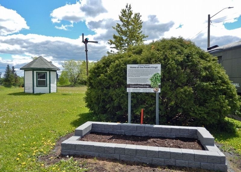
Cochrane has a proud history of farming in the North. More specifically potato farming, with roots dating back more than a century. Cochrane donned the title "Potato Kings" in 1953 when local resident Gabriel Kolomeitz was presented a gold watch by . . . — — Map (db m217897) HM
The surveying of the line which intersects Highway No. 11 here (survey mile post 162) was the first step taken by the Ontario government in the exploration and development of this region. During the 1890s, interest in Ontario's northern mineral, . . . — — Map (db m217895) HM
[English] For centuries the site of Cochrane was used by indigenous peoples as a summer camping ground. Later it became a stopping place for fur traders en route to Moose Factory. In 1907 the Temiskaming and Northern Ontario Railway . . . — — Map (db m217898) HM
[English] A Hudson's Bay Company post named after a son of George III, Frederick House was established in 1785 to prevent Canadian fur traders in the Abitibi region from intercepting the passage of furs to Moose Fort (Moose Factory) . . . — — Map (db m217973) HM
Erected by the citizens of Iroquois Falls and the directors of the company to the memory of Frank Harris Anson 1859-1923 founder and first president of Abitibi Power and Paper Company Limited. — — Map (db m245618) HM
Was and continues to be recognized country wide. It was clear from the onset this town was to reflect strong and fresh designs complete withGarden Town Themes Our town is claimed as being the first planned community in Canada. Research . . . — — Map (db m245498) HM
A new IFPS officially opened on January 16, 1941. At the time Mr. J. L. Harkness (1941-1958) was the principal. In 1977 a new gymnasium was constructed with Mr. Alan Taylor (1958-1985) as principal. In 2006 the school was demolished and . . . — — Map (db m245458) HM
[English] This region's first inhabitants were aboriginal peoples who were attracted by its abundant natural resources and extensive water routes. Europeans arrived in the late 1600s to acquire furs and establish trade with the . . . — — Map (db m217890) HM
The Trueman Gibbens and the Clark Davis Boats were transported from Owen Sound by train and were assembled and launched in Lowbush in 1947 and 1951 respectively. Specifically designed for work in the shallow waters of Lake Abitibi of depths less . . . — — Map (db m245499) HM
The year is 1880 when Ephraim Shay (1839-1916), a man with inventive and mechanical ability, developed a powerful and agile locomotive that could climb, turn and operate on uneven ground. On February 27, 1926, the SHAY 70 rolled off the assembly . . . — — Map (db m245500) HM
Born in Latchford and raised near Porquis Junction, Cosens enlisted in the Argyle and Sutherland Regiment, Canadian Active Service Force, in 1940 and transferred to the Queen's Own Rifles of Canada in 1944. Early on February 26, 1945, his unit . . . — — Map (db m217896) HM
On July 29, 1916, fires which had been burning for some weeks around settlers' clearings along the Timiskaming & Northern Ontario Railway were united by strong winds into one huge conflagration. Burning easterly along a 40-mile front, it largely or . . . — — Map (db m217800) HM
This village had been named originally after an Indian trapper by the name of MacDougall who was descended from an early Hudson’s Bay Factor. With the arrival of the Temiskaming and Northern Ontario Railway in 1906, the village was renamed Matheson . . . — — Map (db m244994) HM
The chute was a narrow, fast water part of the Black River located approximately 1.0 km above the highway 101 bridge. It was here that the MacDougall family and their friends set up an encampment during their journeys through the area. The chute . . . — — Map (db m244991) HM
[English] From the 1880s onwards, as railways opened up northern Ontario, prospecting activity in this region intensified. The Porcupine gold rush began in 1909 following three significant discoveries. Thousands of prospectors and . . . — — Map (db m217899) HM
[English] There is no shortage of stories about the prospectors who came north during the Porcupine Gold Rush of 1909. Life was not easy; they carried 75-pound packs through muskeg and uneven ground. Of course nothing was certain . . . — — Map (db m199240) HM
[English] In the summer of 1911, when the Porcupine gold rush was at its height, the weather was hot and dry. On July 11, gale-force winds from the southwest whipped individual bush fires into a 16-km sea of flames that swiftly . . . — — Map (db m217900) HM
Official opening: January 16, 1939 Reeve: Victor H. Evans Council: George Helmer, Melvin Cavanagh, Emil Heino, William Fairhurst Last council at amalgamation: December 31, 1972 Reeve: Ernie R. White Council: Dennis Pope, Maurice Londry, Luigi . . . — — Map (db m244988) HM
[English] Timmins is one of the richest gold producing areas in the world; the Porcupine Gold Rush led to the extraction of well over 65 million ounces of gold to date and by comparison, the Klondike Gold Rush coaxed out just over 5 . . . — — Map (db m244434) HM
[English] The first French-language radio station in Ontario, CFCL-Timmins, began broadcasting in December 1951. The event was greeted with enthusiasm by Franco-Ontarians who until then had heard limited programming in French over . . . — — Map (db m217793) HM
[English] After the Cariboo and Klondike rushes, gold production in Canada entered a new era with the discovery of lode deposits in the Porcupine area in 1909. The mines in this district, notably the Hollinger which became one of . . . — — Map (db m199247) HM
[English] "Great Rush of men to the Porcupine!" "On to the Porcupine is now the Cry!" Prospectors and speculators came from across the continent to take part in the Porcupine Gold Rush that began in earnest in 1909 with the . . . — — Map (db m244343) HM
[English] Once the ore is mined from the earth, the gold must be removed from the ore. The extraction of gold from ore and refining it into 'pure' gold involves a number of physical and chemical processes that are carried out on an . . . — — Map (db m244417) HM
Erected by the Timmins-Porcupine Chamber of Commerce in June, 1966 to commemorate development of this important zinc, copper, lead, silver discovery (time capsule in base) ————— Celebrating 50 Years of World Class Mining and Metallurgy (2016) Kidd . . . — — Map (db m244446) HM
At this point the 49th parallel of latitude north of the equator crosses the highway. This line forms the southern boundary of the western provinces of Manitoba, Saskatchewan, Alberta and most of British Columbia. In 1818 a treaty between Great . . . — — Map (db m217889) HM
[English] A proud Sudburian, Ted was the creator of the Canadian Centennial Numismatic Park, which was opened on July 22, 1964. Ted spearheaded the creation of the Big Nickel and the original Big Nickel Mine on the . . . — — Map (db m254866) HM
1838 - 1899 William Holditch 1872 - 1958 William Ernest Holditch [English] William Holditch owned and operated one of the first general stores in Sudbury. He was also a prospector and sold mineral rights. His son, . . . — — Map (db m254871) HM
[English] Canada is a leading producer of nickel and the mining of this metal has contributed significantly to the nation’s economy. The industry is closely tied to the Sudbury basin whose mines have produced the . . . — — Map (db m254854) HM
[English] The Society of Jesus opened a classical college at this site in 1913. The next year, the province granted Sacred Heart College a charter giving it degree-granting powers. At first, the college was . . . — — Map (db m254873) HM
[English] In 1949 the Bank of Canada launched a nationwide contest for the design of the 1951 five-cent coin to mark the bicentennial of the chemical isolation of nickel by the Swedish chemist Baron Axel Frederic . . . — — Map (db m254857) HM
[English] Look through the opening to your left at the Superstack at Vale's Copper Cliff Smelter, where nickel-copper ore is heated to high temperatures to extract valuable metals. The Superstack, the . . . — — Map (db m272000) HM
[Français] Important centre de l'église catholique du Nord-Est de l'Ontario, la mission de Sainte-Anne-des-Pins fut créée par les Jésuites en 1883. Une église en rondins, aujourd'hui le presbytère, servait d'école, . . . — — Map (db m261691) HM
[English] The establishment of a Canadian Pacific Railway work camp here in 1883 stimulated the growth of a frontier community. Within a year a bustling settlement containing boarding houses, stores and a hospital . . . — — Map (db m255200) HM
This plaque commemorates the 75th anniversary of the gazetting of The Irish Regiment of Canada and is dedicated to those who have served the Regiment in peace and war and to the memory of those who paid the supreme sacrifice for Canada while . . . — — Map (db m271900) HM
[English] Austin Airways, a pioneering aviation firm, played a leading role in the economic development of the Ontario north in the mid-twentieth century. At first its main business was flying Toronto mining . . . — — Map (db m261300) HM
[English] On petition of the University of Sudbury, the United Church of Canada and the Anglican Diocese of Algoma, supported by prominent citizens, this non-denominational, bilingual institution of higher learning . . . — — Map (db m261696) HM
[English] The Franco-Ontarian Flag was first raised at the University of Sudbury on September 25, 1975, at a time when Sudbury was experiencing unprecedented growth in Franco-Ontarian arts and culture. Conceived by . . . — — Map (db m261800) HM
A ring of low hills, with Sudbury on the south rim, follows the outline of the “Sudbury Nickel Irruptive”, a unique and remarkably complex geological structure. The mines situated around the outer rim of this boat-shaped basin produce most of the . . . — — Map (db m261695) HM
This cairn is erected in memory of the late W. J. Bell who donated these parks to the citizens of Sudbury for their enjoyment and for the beautification of the city — — Map (db m271896) HM
You are now entering Algonquin,
the oldest and most famous
provincial park in Ontario. Since
1893, this vast expanse of forest
lakes, and rivers has protected
some of our most precious natural
and cultural heritage and . . . — — Map (db m284489) HM
To the memory of
Tom Thomson
artist woodsman and guide
who was drowned in Canoe Lake
July 8th 1917
He lived humbly but passionately
with the wild. It made him brother to all untamed things of nature.
It drew him apart and . . . — — Map (db m309398) HM
First recognized in 1951 from aerial photographs, the crater
is a circular depression about two miles in diameter formed
in Precambrian crystalline rocks. Geophysical and diamond
drilling investigations show that the crater has a present
depth . . . — — Map (db m284109) HM
Early in 1951, John A. Roberts (president of Spartan Air Services
in Ottawa) was looking at high-altitude aerial photographs taken
by his company north of Brent and noticed an almost perfectly
circular feature about 3 kilometres . . . — — Map (db m284111) HM
Louise Flach was born in Sweden and grew up on the scenic Baltic coast where she developed an interest in nature. Flach became a Red Cross nurse, serving during the First World War in Denmark, and then with her first husband Greb de Kiriline who . . . — — Map (db m105640) HM
Frank A. MacDougall, in whose honour the Parkway was named, served in the Department of Lands and Forests from 1923 until 1966.
From 1931-1941 he was Superintendent of Algonquin Park with headquarters located at nearby Cache Lake. During his term . . . — — Map (db m147900) HM
Here, when the canoe was the principal means of travel, explorers, voyageurs, missionaries and others bound for the West, left the Ottawa River and followed the Mattawa River to Lake Nipissing, the French River and the upper Great Lakes. For over . . . — — Map (db m105630) HM
Francophone settlement rapidly increased in the Mattawa area with the arrival of the Canadian Pacific Railway (CPR) in 1881. During construction of the rail line, the local economy benefitted from the presence of thousands of French-Canadian . . . — — Map (db m105625) HM
Trading in furs at this junction of historic canoe routes probably began during the French regime. At intervals during the 1820's and 1830's Chief Trader John Siveright, commanding the Hudson's Bay Company's post at Fort Coulonge, sent men to trade . . . — — Map (db m105629) HM
When west-bound voyageurs left the Ottawa here at Mattawa, "the forks," they faced 11 portages in the next 40 miles. The Mattawa, or Petite-Rivière, was a key link in the historic canoe route between Montréal and the upper Great Lakes and . . . — — Map (db m105631) HM
[English] The arrival of Samuel de Champlain on this site, on July 26, 1615, represents one of the first manifestations of the French language in this region of Ontario. "Continuing our way by land, after leaving . . . — — Map (db m215900) HM
North Bay Public Libraries have been located on this downtown block — bordered by McIntyre, Wyld, Worthington and Sherbrooke Streets — since 1914 when a Carnegie Library opened its doors. The Carnegie wasn't North Bay's first library. . . . — — Map (db m215930) HM
The rivers and lakes of northern Ontario have been highways for travel and commerce for hundreds of years. Used extensively by first nations and European explorers, Lake Nipissing became a major highway with half the furs shipped to . . . — — Map (db m215897) HM
The Cormack Block was built circa 1890 and was named for John G. Cormack, North Bay's first pharmacist (druggist). The block is recognized as the oldest Main Street commercial structure that still stands and over the years it has housed . . . — — Map (db m215876) HM
The extensive Canadian Pacific Railroad yards and repair shops dominated the North Bay waterfront for better than three quarters of a century. CPR steel reached what was to become North Bay in 1882 and it soon became evident that this . . . — — Map (db m215894) HM
Don King served his country as a war veteran and also served our community as a capable, committed and conscientious Reeve, Councillor and Alderman over a 35 year period. He was a staunch supporter of community projects that he believed would . . . — — Map (db m215985) HM WM
Scottish born John Ferguson (1861-1946), a nephew of Canadian Pacific Railroad vice-president Duncan McIntyre, arrived here with CPR steel in 1882. Credited with being a key founder of North Bay, Ferguson, whose vocation was described as . . . — — Map (db m215887) HM
This arch was erected by the North Bay Travellers and their friends in 1928. In 1934 this group was incorporated as the North Bay Club of the Associated Canadian Travellers, and the arch became the logo of the City of North Bay. On the 50th . . . — — Map (db m215997) HM
The lonely piece of pavement curving off Memorial Drive next to this heritage site plaque, and deadending at the Stanley Street bridge, was once part of North Bay's only road link to the southern part of the province. Construction of . . . — — Map (db m215995) HM
This public gathering place is named in honour of Jack Burrows — athlete, husband, father, grandfather, businessman, Rotarian, long time public servant and North Bay Mayor from 1995 to 2003. Of Irish stock, the Burrows family arrived in . . . — — Map (db m215892) HM
Born in France about 1598, this explorer, fur trader and interpreter came to Canada in 1608. Under orders from Samuel de Champlain, he spent the following two years with the Algonquins of Allumette Island. He was then sent to the Nipissing Indians . . . — — Map (db m107579) HM
The historic La Vase (Mud) Portages began at the head of the nearby pond. These three portages, connecting Trout Lake and the lower La Vase River, were linked by small navigable streams and ponds. They formed part of the great canoe route via the . . . — — Map (db m107582) HM
From this point the Canadian explorers and early fur-traders caught their first glimpse of Lake Nipissing as they paddled westward on their journey from Montreal by way of the Ottawa, Mattawa and French Rivers to the Great Lakes. Champlain viewed . . . — — Map (db m199966) HM
Stepping off a passenger train at the Canadian Pacific Railway Station, visitors to North Bay in the early 1900s saw a very different town than exists today. There was a large park on one side of the station, and across the street, known . . . — — Map (db m215893) HM
The vast body of water before you is a shining Northern gem. Known as Lake Nipissing, the name being derived from an Aboriginal term meaning "little water", it is one of the ten largest lakes in Ontario at roughly 65 km by 25 km. When . . . — — Map (db m215993) HM
This city block bounded by Fraser, First, Ferguson and Second became the site of the North Bay Normal School, which opened in 1909 and still stands on the corner of First & Fraser. In 1917, the province deeded the remainder of the tract for use as a . . . — — Map (db m195967) HM
North Bay citizens have long enjoyed a refreshing tankard and for a short time in the early 20th Century, residents were served by their own brewery. The New Ontario Brewing Company Ltd. was the area's first commercial brewery, producing . . . — — Map (db m215898) HM
The first known lockup in North Bay was a rudimentary log structure built in 1886 at the corner of Main and Wyld Streets. Two years later the province constructed a court house and lockup on Bye, now Plouffe, Street which evolved into a . . . — — Map (db m216000) HM
North Bay has a long and storied hockey history and, over the years, a number of rinks and arenas have served the needs of citizens. The North Bay Arena Rink stood near this site at the corner of Main Street West and Murray Street. Today . . . — — Map (db m215947) HM
In 1999, Barry Jacobs, a dedicated volunteer with the Heritage Railway Co., had a dream; a full scale carousel to complement the successful train at the North Bay Waterfront. Rod Johnston, one of the founders of the Heritage Railway Co. embraced . . . — — Map (db m215989) HM
[English] The red brick structure on this site was the home of teacher education in North Bay from 1909 until 1972. Originally the North Bay Normal School, it was renamed North Bay Teachers' College in 1953.
In 1972 the teacher education . . . — — Map (db m195971) HM
John Ferguson was North Bay's first postmaster for a few weeks in 1883, operating out of his boardwood cabin. He was succeeded by William McDonald who opened a general store and post office that same year. McDonald was postmaster for 25 . . . — — Map (db m215800) HM
The construction of the Town Hall represented a defining moment in North Bay's early development. Until it was built, most municipal affairs were carried out at the Cormack block, located beside the current pedestrian laneway on Main . . . — — Map (db m215954) HM
A zealous Methodist missionary descended from an early New England family, Huntington was born in Kemptville. With his ordination in 1854 he commenced a long Christian ministry, serving various congregations in eastern Ontario and Quebec until 1882 . . . — — Map (db m107571) HM
The Royal Theatre, under various names and owners, was one of North Bay's most important cultural and entertainment venues for close to forty years. Built in 1908 for $50,000 to a design by H. W. Angus, the Royal Theatre, also called . . . — — Map (db m215895) HM
On this site in 1975 an accident during routine excavation led to the biggest single tragedy and loss of life in North Bay's history. In the afternoon of January 8, a five man crew from the gas company working next door using a backhoe . . . — — Map (db m215891) HM
From 1979 to 2009, a Bomarc missile was mounted on a pedestal at this site in Lee Park (now Veteran's Fields) serving as a monument to one of the most important and controversial aspects of North Bay's history in the late 20th century. . . . — — Map (db m215899) HM
The Capitol Theatre opened on this site on June 1, 1929. The sold out opening night movie feature was a "talkie" titled, In Old Arizona. Known as "Northern Ontario's Most Beautiful Theatre," it resembled that of old Hollywood. The walls . . . — — Map (db m215799) HM
[English] The CF100 “Canuck” was conceived to meet the demanding requirements of defending a country as vast as Canada. It was a two place, all weather high altitude long range interceptor built in Canada. It first . . . — — Map (db m215998) HM WM
In 1900 the Ontario Government ordered a survey for a railway from North Bay to the head of Lake Timiskaming to encourage settlement and provide access to mineral deposits. Construction of the Temiskaming and Northern Ontario Railway began in 1902, . . . — — Map (db m107572) HM
To mark the 50th anniversary of the end of WWII this park and the playing fields therein are gratefully dedicated to all those who have served Canada in any military endeavour or peacekeeping mission. They served with valour so we may remain free. . . . — — Map (db m215798) WM
The Winter Wonderland Carousel was instigated by the North Bay Carousel Carvers. As the North Bay Heritage Carousel came close to completion it became apparent that the carvers would soon be out of work. However, this stalwart band of volunteers . . . — — Map (db m215994) HM
The development of Sturgeon Falls began in 1881 with the arrival of Canadian Pacific Railway constructions teams and the opening of a post office. About a year earlier the community's first permanent settler, James Holditch, had acquired land here . . . — — Map (db m107569) HM
In 1902, The Temiskaming and Northern Ontario Railway Act was given Royal Assent and construction of the railway, now operated by the Ontario Northland Transportation Commission began. By 1904 the line which was 1o link North Bay and New Liskeard . . . — — Map (db m195961) HM
Born in Kamouraska County, Québec, Paradis studied at Sainte-Anne-de-la-Pocatière College and taught art in Ottawa. Following his ordination in 1881 he was posted to Lake Timiskaming as missionary of the Oblate Congregation. Paradis' travels as a . . . — — Map (db m107568) HM
Established in 1893, Algonquin was the first provincial park in Canada and the forerunner of Ontario’s extensive park system. Many methods now used across Canada to administer multi-purpose parks and explain nature to the public were developed . . . — — Map (db m59998) HM
The author of "Maria Chapdelaine", Hémon was born at Brest, France. He immigrated to Canada in 1911 and spent about eight months in the Lac St. Jean region of Quebec. While working on a farm near Péribonka, he wrote this well known novel, a story . . . — — Map (db m106529) HM
The people of Massey have been actively involved in sports from the town's earliest times to the present. Massey is the “Home of Broomball”. One day a little girl was observed sweeping her rubber ball with a broom. Members of the local soccer team . . . — — Map (db m272220) HM
The valiant men and women of all creed & colour who gave their lives that we may live in freedom We will remember them on se souviendra — — Map (db m271891) WM
Introduction The lumbering industry began in this area in the 1860's. There was a great demand for lumber in Canada, the U. S. A. and abroad. The vast stands of white and red pine of the Massey area met this need. Thousands of workers produced . . . — — Map (db m272219) HM
Introduction Many lumbermen settled on the land that had been cleared by the lumber industry. They began to grow crops of hay and grain for the horses, and meat and vegetables for the men. Settlements began to develop — i.e. River Road, Lee . . . — — Map (db m272221) HM
While laying out a meridian line (a north-south survey line) in 1856, provincial land surveyor Albert Salter observed severe compass needle deflections some five kilometres north of here. Alexander Murray, assistant provincial geologist, examined . . . — — Map (db m106532) HM
The Hudson's Bay Company had established a fur trading post on the western shore of Whitefish Lake by 1824. It was hoped that a depot adjacent to the portage route to Wakami Lake would help prevent independent traders in Michigan, Wisconsin and . . . — — Map (db m106534) HM
Large stands of timber attracted the logging industry to the Hallam Township area and by the 1880s four logging camps had been established. The Canadian Pacific Railway followed, opening a spur line between Sudbury and Algoma Mills to service the . . . — — Map (db m255181) HM
[English] On Victoria Day Monday, 1977 a fire was accidentally started in the Rowden Hardware Building which stood on this spot. The high winds and hot weather carried the fire down the hill into the tightly-packed . . . — — Map (db m304984) HM
[English] This plaque commemorates the founding of Agnico Mines Limited in Cobalt, Ontario in 1957. It is dedicated to those men and women whose commitment, perseverance and spirit helped to transform Agnico into a . . . — — Map (db m304973) HM
200 entries matched your criteria. The first 100 are listed above. Next 100 ⊳