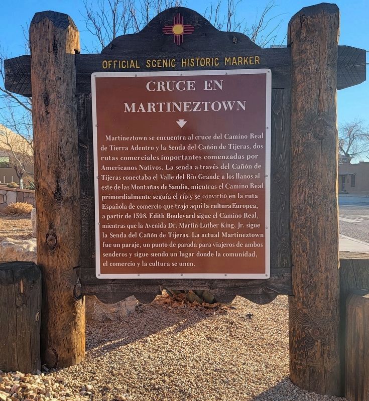
Martineztown is at the crossroads of El Camino Real de Tierra Adentro and Tijeras Canyon Trail, two important trade routes begun by Native Americans. The trail though Tijeras Canyon linked the Rio Grande Valley to the plains east of . . . — — Map (db m189456) HM
The first permanent Spanish settlement brought new foods and cooking methods to the region in the late 1500s. Wheat became an important staple because it was easier than corn for making bread. Pueblo men learned to harvest wheat while the woman . . . — — Map (db m120169) HM
One of the Largest Petroglyphs Sites
Petroglyph National Monument protects one of the largest petroglyph sites in
North America, featuring designs and symbols carved onto basalt boulders by
American Indians and Spanish settlers 400 to 700 . . . — — Map (db m182649) HM
Piedras Marcadas Canyon The warmth of the sun, the whispers of the wind, the volcanic boulders, native plants, and desert animals are what the Pueblo people and other visitors to this volcanic landscape valued. Ancestral Puebloans were . . . — — Map (db m183130) HM
Piedras Marcadas Trail
The majority of these petroglyphs were made
by the ancestors of modern Pueblo people. The Ancestral Puebloans made petroglyphs by
carefully removing the desert varnish with hand-held stone tools to expose the . . . — — Map (db m183134) HM
Piedras Marcadas Trail
Identification of some petroglyphs is based
on interpretations by today's Pueblo people.
We cannot say for certain what all the images
represent, nor is it appropriate for modern
Pueblos to reveal the meaning of an . . . — — Map (db m183168) HM
Piedras Marcadas Trail
Petroglyphs represent a valuable record of
cultural expression and human occupation
in the Rio Grande valley. They have deep
spiritual significance to modern Pueblo
groups as well as other indigenous people
such . . . — — Map (db m183170) HM
La Jornada (The Journey), the bronze sculptural grouping on the corner along with the adjacent earthen work Numbe Whageh (Our Center Place) make up the City of Albuquerque's 1% for the Arts Funds Cuarto Centenario Memorial. The memorial . . . — — Map (db m71142) HM
Boca Negra Canyon Boca Negra, the “black mouth,” is considered
the birthplace of Petroglyph National Monument. Through the efforts of private citizen groups in
the 1960s, this area became Indian Petroglyph State Park, which later became the . . . — — Map (db m182696) HM
Boca Negra Canyon
Cliff Base Trail
The boulder on your left is a good example of desert varnish,
the darkening of the rock's surface in response to natural
elements. Over the years the exposed surface of basalt darkens
in color due to . . . — — Map (db m182902) HM
Boca Negra Canyon
Cliff Base Trail
Archeologists, currently using relative dating methods along
the escarpment, are arriving at the conclusion that the 23,000
petroglyphs found in the monument were created between
1000 B.C. — A.D. 1700. . . . — — Map (db m182865) HM
Boca Negra Canyon
Macaw Trail
The majority of these petroglyphs were made by the
ancestors of modern Pueblo people. The Ancestral
Puebloans made petroglyphs by carefully removing the
desert varnish with hand-held stone tools which . . . — — Map (db m182821) HM
Boca Negra Canyon
Macaw Trail
Native vegetation is commonly featured in petroglyphs. This
yucca pod image conveys the importance of many native plant
species to the Ancestral Puebloans. The entire plant, from its
root to the tip of its . . . — — Map (db m182858) HM
Boca Negra Canyon Mesa Point Trail
Petroglyphs represent a valuable record of cultural expression
and human occupation in the Rio Grande valley. They have
deep spiritual significance to modern Pueblo groups as well as
other indigenous . . . — — Map (db m182697) HM
Boca Negra Canyon Mesa Point Trail
Notice the human figure in front of you which appears to be
wearing a mask and headdress. Some petroglyphs are easily
recognizable, however the original and true meanings are known
only by their creators . . . — — Map (db m182701) HM
Boca Negra Canyon Mesa Point Trail
Several stacked rock structures like this one are found in the
monument and are protected as archeological resources. This
structure has naturally eroded to its present state. Local
archeologists believe . . . — — Map (db m182703) HM
Boca Negra Canyon Mesa Point Trail
Due to extended periods of drought, the Pueblo people
searched for permanent sources of surface water that would
sustain their agricultural lifestyle. Many people settled along
the Rio Grande which . . . — — Map (db m182722) HM
Boca Negra Canyon Mesa Point Trail
Identification of some petroglyphs is based on interpretations
by today's Pueblo people. We cannot say for certain what all
the images represent, nor is it appropriate for modern Pueblos
to reveal the . . . — — Map (db m182724) HM
Boca Negra Canyon
Cliff Base Trail
Although some images are easily recognizable (such as these
human footprints) according to modern Pueblo people, it is
culturally insensitive to reveal the meanings of some petroglyphs. While these . . . — — Map (db m183107) HM
Petroglyph National Monument What type of rock is this? The rock that makes up the West Mesa escarpment is vesicular basalt. The basalt flow originated from fissures marked by five volcanic spatter cones that be seen along the western horizon . . . — — Map (db m182820) HM
Boca Negra Canyon
Cliff Base Trail
Notice that the prehistoric petroglyphs face south or
southeast. Perhaps this placement was deliberate to the
orientation of the daily rising sun. It is also thought that
many of the images were made . . . — — Map (db m182859) HM
Boca Negra Canyon
Cliff Base Trail
The placement of petroglyphs was deliberate based on the
boulder's orientation to the sun and the surrounding landscape.
Some boulders contain petroglyphs on east-facing sides while
other boulders have . . . — — Map (db m183109) HM
Boca Negra Canyon
Cliff Base Trail
Authentic petroglyphs are valuable and irreplaceable cultural
resources that provide us with insight of the prehistoric
civilizations that once thrived here. Protecting these cultural
treasures is a . . . — — Map (db m182876) HM
Boca Negra Canyon
Cliff Base Trail
There are many complex and dynamic reasons why the
Ancestral Puebloans made their petroglyphs here. Some
possible reasons are based on cultural and spiritual beliefs.
Some Native Americans believe . . . — — Map (db m182862) HM
Boca Negra Canyon
Cliff Base Trail
Archeologists refer to these images as being made in the Rio
Grande style. This style developed rather suddenly around
the year 1300, coinciding with a dramatic increase in the local
population and the . . . — — Map (db m182903) HM
Imagine the sounds of chickens, the smell of horses and bustling of human activity. You are standing at the entrance of the plaza, which offers a sense of the historical layout that changed throughout time but was typical of the Spanish colonial . . . — — Map (db m185573) HM
The pass between the Sandia and Manzano Mountains has been a natural route of travel between eastern New Mexico and the Rio Grande Valley since pre-historic times. Known as Cañón de Carnué in the Spanish colonial period it takes its present name . . . — — Map (db m72732) HM
The mountains and the town were named for Juan Ignacio Flores Mogollón, governor of New Mexico from 1712 to 1715. The name also is applied to the Pueblo Indians who abandoned the area in the early 1400s. These mountains were inhabited by Apaches . . . — — Map (db m38255) HM
Population 600 — Elevation 5765 ft.
Located in the San Francisco Valley, Reserve was named upper San Francisco Plaza by its original Hispanic settlers in 1874. The name was later changed to Reserve in recognition of the U.S. Forest Service . . . — — Map (db m36258) HM
Population 600 — Elevation 5765 ft.
Located in the San Francisco Valley, Reserve was named upper San Francisco Plaza by its original Hispanic settlers in 1874. The name was later changed to Reserve in recognition of the U.S. Forest Service . . . — — Map (db m36261) HM
Gila Cliff Dwellings National Monument was established in 1907 by Theodore Roosevelt to protect the prehistoric material culture of the Mogollon people and others who inhabited this area. The first scientific description of a pueblo ruin on the . . . — — Map (db m157800) HM
Although the design on the wall in front of you has faded since it was painted 700 years ago, its meaning remains. Some modern Puebloan people who claim cultural affiliation with the Mogollon interpret similar designs to symbolize rain or clouds. . . . — — Map (db m157799) HM
Legend describes Acoma as a "place that always was". Archaeological evidence shows it has been occupied since at least the 13th century. Established on this
mesa for defensive purposes, Acoma was settled by inhabitants of nearby pueblos which had . . . — — Map (db m30263) HM
Legend describes Acoma as a "place that always was". Archeological evidence shows it has been occupied since at least the 13th century. Established on this mesa for defensive purposes, Acoma was settled by inhabitants of nearby pueblos which had . . . — — Map (db m36505) HM
Built atop a great mesa for defensive purposes, Ácoma has been continuously occupied since the 13th century. A dramatic battle between the Ácomas and Oñate's forces occurred here in 1599. The mission church of San Esteban was built between 1629 and . . . — — Map (db m36502) HM
Keresan speaking refugees from Santo Domingo, Acoma, Cochiti, and other pueblos founded Laguna after the Pueblo Revolt of 1680 and the Spanish reconquest of 1692. Named by the Spaniards for a marshy lake to the west, the pueblo still occupies its . . . — — Map (db m36504) HM
San Rafael, formerly know as El Gallo, is located at a spring near the Malpais, the great lave flow to the east. The area was visited by members of Vásquez de Coronado's expedition in 1540. In 1862, it was selected as the original site of Fort . . . — — Map (db m36475) HM
Keresan speaking refugees from Santo Domingo, Acoma, Cochiti, and other pueblos founded Laguna after the Pueblo Revolt of 1680 and the Spanish reconquest of 1692. Named by the Spaniards for a marshy lake to the west, the pueblo still occupies its . . . — — Map (db m36506) HM
Keresan speaking refugees from Santo Domingo, Acoma, Cochiti, and other pueblos founded Laguna after the Pueblo Revolt of 1680 and the Spanish reconquest of 1692. Named by the Spaniards for a marshy lake to the west, the pueblo still occupies its . . . — — Map (db m36521) HM
(Front of Marker:)
The picturesque mission church of San José de la Laguna was built around 1706 by Fray Antonio Miranda and shows the single – aisle floor plan commonly used in pueblo churches. It has been repaired many times, and . . . — — Map (db m36520) HM
Educated at the Carlisle Indian School in Pennsylvania under the U.S. policy of acculturating Indian children through school and removal from their homelands, Susie was instrumental in bringing education back to Laguna. A lifelong teacher, oral . . . — — Map (db m36519) HM
Business Along Route 66
As traffic along the road increased, Laguna community members began to sell or trade items at roadside stands within the Pueblo and on adjoining lands to the east and west. Community members built shade structures . . . — — Map (db m184000) HM
Atsinna, which means where pictures are on the rock, was occupied from roughly 1275 to 1400 by ancestors of today’s Zuni people. Eighteen rooms were excavated in 1954, 1955, and 1961. Today, however, the focus at El Morro has shifted from . . . — — Map (db m163205) HM
Until it was by-passed by the railroad in the
1880’s, its waterhole made El Morro an
important stop for travelers in the Acoma-
Zuni region. Numerous inscriptions carved
in the sandstone date from the prehistoric,
Spanish, Mexican, and . . . — — Map (db m14129) HM
Also known as squawbush, this aromatic shrub is a member of the same plant family that includes poison ivy, cashews, pistachios, and mangos. The stems of this plant have been used by Native Americans for many years in basketmaking, while the tart . . . — — Map (db m163237) HM
Matilda Coxe Stevenson was the first female anthropologist to study the Native Americans of New Mexico. Her research focused on the religious practices of indigenous peoples, particularly of the Zuni, and on the lives of native women and children. . . . — — Map (db m163186) HM
From the early Puebloan people who built their homes atop this rock, to the many explorers and adventurers who carved their names, to modern visitors who travel here looking for the evidence of those who came before, El Morro reflects the history of . . . — — Map (db m163199) HM
Carved into the soft sandstone cuesta before you is a lingering history of the American Southwest. The names of the celebrated, the infamous, the legendary, and the unknown are immortalized side by side where they would otherwise be separated by . . . — — Map (db m163198) HM
Eagle Nest was a place where members of several Indian tribes were said to have come to collect ceremonial feathers. Before 1919, Charles Springer acquired the land and built a dam for irrigation. It now has a capacity of 78,000 acre feet and . . . — — Map (db m45752) HM
During the 1700s and early 1800s, Comanche Indian buffalo hunters used trails that passed near here. In 1907 the Santa Fe Railroad established Clovis to serve as the eastern terminal of the Belen Cutoff, which would connect with the transcontinental . . . — — Map (db m145061) HM
The U.S. Army established Fort Sumner in 1862 as a supply and control point for the Bosque Redondo Indian Reservation. About 10,000 Navajo were forcibly relocated from the Four-Corners Region during the tragic march known as the Long Walk. About 500 . . . — — Map (db m73718) HM
You are entering the grounds of historic Fort Sumner, headquarters of the Bosque Redondo Indian Reservation.
Over 400 Mescalero Apache and 7,000 Navajo were held here as prisoners of war. The museum tells their stories. — — Map (db m145060) HM
Stagecoaches of the Butterfield Overland Mail Co. began carrying passengers and mail from St. Louis to San Francisco, across southern New Mexico, in 1858. The 2,795-mile journey took 21-22 days. In 1861 the service was re-routed through Salt Lake . . . — — Map (db m6553) HM
Originally established as Santa Barbara in 1851, Apache raids drove the settlers away until 1853 when nearby Fort Thorn was established. Abandoned again in 1860 after the fort closed, it was reoccupied in 1875 and re-named for General Edward Hatch, . . . — — Map (db m24745) HM
Fort Selden was established to protect settlers and railroad construction crews in the Mesilla Valley and the Jornada del Muerto from Apaches. The first regular army troops to garrison it were four companies of the black 125th Infantry. General . . . — — Map (db m45085) HM
English: As you look across this landscape, use your imagination to "see" how people lived and passed by this spot throughout history. Ancient village — 1,000 years ago Look along the ridge and imagine a village built by . . . — — Map (db m158085) HM
In July 1867 Oliver Loving, a partner in the Goodnight-Loving cattle concern, was attacked by Comanches while driving cattle to Fort Sumner. Wounded, Loving held off the attack for two days and nights. With the help of Mexican traders, he made it to . . . — — Map (db m61471) HM
People have lived in the Mimbres Valley since at least 2000 B.C. and probably earlier. Small villages of farmers lived in pithouses—underground single-family structures—by A.D 200. Around A.D. 1000, people began erecting pueblos, similar . . . — — Map (db m121824) HM
Mangas Coloradas was one of the most highly
regarded leaders among the Chiricahua Apaches. Born c 1795, he was noted for his sagacity, diplomacy, and at 6'6" his height. He met with U.S. General Kearny in 1846 and in 1852 negotiated the only . . . — — Map (db m162263) HM
The Mattocks Ruin is a large Mimbres archaeological site with pithouses and a pueblo dating more than 1,000 years ago. The site was once the home of the Mimbres people, Native Americans who left behind extraordinary black and white pottery which . . . — — Map (db m121956) HM
From the earliest times, surface ore in this area attracted Native Americans who used the natural copper to make ornaments, trade goods, and weapons. In 1799, during the Spanish colonial period, an Apache Indian showed Jose Manuel Carrasco an . . . — — Map (db m157877) HM
The early years of mining were turbulent, with numerous explorers and adventurers attempting to conduct mining operations here. Fur trappers Sylvester Pattie and son James tried their hand at mining copper and used the underground mines to store . . . — — Map (db m157881) HM
Silver City is located in the midst of rich mineral deposits. The Santa Rita Copper Mines, opened in 1805, were the second such mines operating in what is now the U.S. A silver strike in 1870 began the commercial mining for which the area is still . . . — — Map (db m38231) HM
By 1700 the Comanches had acquired the horse and began moving into this area. They drove out the Jicarilla Apaches, and their raids on New Mexico's eastern frontier posed a threat to Indian, Spanish and Anglo settlements for over a century. The . . . — — Map (db m93763) HM
Gila Cliff Dwellings National Monument was established in 1907 by Theodore Roosevelt to protect the prehistoric material culture of the Mogollon people and others who inhabited this area. The first scientific description of a pueblo ruin on the . . . — — Map (db m38242) HM
Nomadic Indians and countless buffalo herds dominated this vast plain when the Vásquez de Coronado expedition explored it in 1541. Later it was the focus of Comanchero activity, and in the 19th century it became a center for cattle ranching. The . . . — — Map (db m73464) HM
A pioneer in the preservation of the history of people in Southeastern New Mexico, Eve wrote over 150 articles and numerous books chronicling Mescalero and Chiricahua Apaches, Anglo and Hispanic settlers. Her honesty, patience and determination . . . — — Map (db m45957) HM
One of Lincoln's earliest structures. Built in the 1850's, its thick walls protected Spanish-Americans against the Apaches. In Lincoln Co. War Murphy's sharpshooters were here stationed. In 1937 Chaves County Historical Society undertook restoration . . . — — Map (db m45990) HM
Located near the ancient Indian sites of the Pajarito Plateau, Los Alamos is one of New Mexico's newest towns. In 1942 a boys ranch school became the headquarters of the Manhattan Project, which led to the development of the atomic bomb. Los Alamos . . . — — Map (db m196361) HM
101 North Third Street (circa 1887)
Adequate transportation has been the answer to successful business entrepreneurs in the Gallup area as early as the late 1880's. Clinton N. Cotton, a shrewd Yankee trader and businessman, concluded that . . . — — Map (db m184301) HM
Long a major trading center for the Navajo and Zuni Indians living in communities north and south of the town. Gallup emerged in 1881 from a railroad construction camp. It is named for David Gallup, who in 1880 was paymaster for the Atlantic & . . . — — Map (db m36541) HM
Gallup, New Mexico, the Indian Capital of the World is known as the epicenter of Native American history, art, culture and tradition in the southwest.
Europeans, Asians, and Mexicans came to build the railroad, and many stayed on to mine coal. . . . — — Map (db m184299) HM
Established September 28, 1922
In August, 2011 Gallup played host to the 90th Inter-Tribal Indian Ceremonial where, Native Americans from across the United States participate in a massive celebration and display of their culture. The Indoor . . . — — Map (db m184300) HM
In 1864 during a period of destabilization among U.S. settlers, Spanish inhabitants and Native Americans, the Navajo and some Apache were singled out by the U.S. government as responsible for raiding. Thousands of Navajo people were forcibly marched . . . — — Map (db m148698) HM
This mural shows the Navajo Code Talkers, U.S. Marines in World War II, who defended this country with the sacred Navajo language, bringing the Code Alphabet home from war to the future generations as a symbol to perpetuate the Navajo language and . . . — — Map (db m148699) HM
Centuries before Gallup's founding in 1881 this was a region of interweaving native cultures, Navajo, Hopi and Zuni. Resources of coal, timber, railroads and trading attracted settlers who created a city of increasing cultural diversity.
We . . . — — Map (db m148758) HM
The Zuni Pueblo is 40 miles south of Gallup. Zuni land-use area, which included what is now Gallup, has been inhabited since 1,000 BC. By 1350 AD agriculture was fully developed and there were approximately 36 active Zuni pueblos. The Spanish . . . — — Map (db m148701) HM
This area contained many Indian pueblos dating from about A.D.
500 to 1325, when it was abandoned. Navajos settled here by
1800. This was the home of Manuelito, one of the last of the
chiefs to surrender for confinement at the Bosque Redondo . . . — — Map (db m162257) HM
The six original Zuni pueblos were the legendary "Seven Cities of Cibola" sought by Vasquez de Coronado in 1540. They were abandoned during the Pueblo Revolt, and the present pueblo was settled in 1699 after the Spanish reconquest. In 1970 Zuni . . . — — Map (db m36582) HM
The six original Zuni pueblos were the legendary "Seven Cities of Cibola" sought by Vasquez de Coronado in 1540. They were abandoned during the Pueblo Revolt, and the present pueblo was settled in 1699 after the Spanish reconquest. In 1970 Zuni . . . — — Map (db m36584) HM
The Zuni Olla Maidens are an all-women's group renowned for their skill and ability to balance fragile water jars or ollas on their heads. Historically, Zuni women collected water in ollas from nearby springs for everyday use. Today, they perform in . . . — — Map (db m36580) HM
In New Mexico, women blessed with special knowledge of herbs, household remedies, human health and strong faith are trusted to cure real or imaged maladies. Known as Curanderas, these women have been an integral part of the Hispanic fabric in . . . — — Map (db m73273) HM
Wagon Mound is the westernmost natural landmark on the Santa Fe Trail. It could be seen for miles by weary travelers making their way over the long and arduous road. The promontory was named by the trail travelers for its resemblance to a large . . . — — Map (db m156740) HM
The low line of trees to the south marks La Junta (the junction) of the Mora and Sapello Rivers. It is also known as La Junta because its location is where the Cimarron and Mountain Branches of the Santa Fe Trail join. Arriving with the U.S. . . . — — Map (db m156802) HM
Fort Union Arsenal (marker south side)West of Fort Union near the base of the mesa are the ruins of Fort Union Arsenal. The first Fort Union was built at this location in 1851. In 1867 this wooden fort was razed and the adobe Arsenal . . . — — Map (db m156765) HM
On the hillside in front of you, the wagon ruts of the Santa Fe Trail bear silent witness to the passage of time and nations moving east and west. When Mexico won its independence from Spain in 1821, legal trade began between the United States and . . . — — Map (db m156801) HM
If you look straight ahead about a mile, you can see the site of the first Fort Union. There, at the foot of the mesa, soldiers quickly threw up buildings made from logs and uncured, rough-sawn lumber in the summer of 1851. Their mission was to . . . — — Map (db m149182) HM
Today it's tough to look at the low wagon wheel ruts of the Santa Fe Trail — just ahead of you and grasp how many tens of thousands of lives this road turned upside down. Comanche, Kiowa, Jicarilla Apache, Mountain Ute, and other American . . . — — Map (db m149008) HM
Like surging tides upon the shore, a procession of human cultures has influenced this region. Each new wave of people left unique impressions on the landscape and each other. 1100-1900 Jicarilla Apache, Ute, Comanche, Pueblo, and other . . . — — Map (db m156804) HM
For the Mescalero Apache, Dog Canyon was a favorite camping area and trail through the Sacramento Mountains. It was the scene of several battles in the 19th century. In 1863 a group of Mescaleros was attacked by soldiers, and the survivors were sent . . . — — Map (db m72719) HM
In this immediate vicinity, Captain Henry W. Stanton of the U.S. Army, for whom Fort Stanton was named, lost his life in 1855 in a skirmish with the Mescalero Apaches. For several weeks, soldiers commanded by Stanton and Capt. Richard S. Ewell, were . . . — — Map (db m73434) HM
Lozen, a warrior and sister of the famous Warm Springs Apache chief Victorio, fought alongside her brother until his death in 1880 and later with his successors, Nana and Geronimo. Lozen also was a medicine woman and healer and, it was said, . . . — — Map (db m46033) HM
Inhabitants of a nearby village made the Three Rivers Petroglyphs (rock carvings) over 600 years ago. Over 20,000 petroglyphs have been identified in the area. The people were of the Jornada Mogollon (hor-NAH-da muggy-OWN) prehistoric Indian . . . — — Map (db m46042) HM
Three miles east of here is one of the most concentrated arrays of petroglyphs in the Southwest. Along a mile-long volcanic ridge are some 21,000 images depicting animals, humans, plants and geometric shapes making it one of very few sites with . . . — — Map (db m91007) HM
Three miles to the east is a mile-long array of pictures pecked into the solid rock walls of a volcanic ridge. They include both geometric and animal forms. They were likely made by prehistoric Mogollón Indians between ca. A.D. 1000 and 1400. — — Map (db m46040) HM
The Tularosa Basin has been occupied by Indian groups for thousands of years. The first Hispanic settlers moved here from the Rio Grande Valley in 1862. Anglo settlers and cattlemen began moving into the region in the 1870s. The original 1862 . . . — — Map (db m46072) HM
By 1700 the Comanches had acquired the horse and began moving into this area. They drove out the Jicarilla Apaches, and their raids on New Mexico's eastern frontier posed a threat to Indian, Spanish and Anglo settlements for over a century. The . . . — — Map (db m118323) HM
Historic Los Luceros includes a Pueblo Indian ruin and an 18th century rancho/hacienda on Sebastián Martin Serrano's 1703 land grant. Evolving out of family inheritance, local artistry and preservation efforts, the complex contains five adobe . . . — — Map (db m45711) HM
A major encounter between the U.S. Army and a large group of Utes and Jicarilla Apaches occurred here in July 1848. Old Bill Williams, the famous scout and guide, was badly wounded while fighting the Utes, who had once adopted him as a tribesman. — — Map (db m125499) HM
197 entries matched your criteria. The first 100 are listed above. The final 97 ⊳