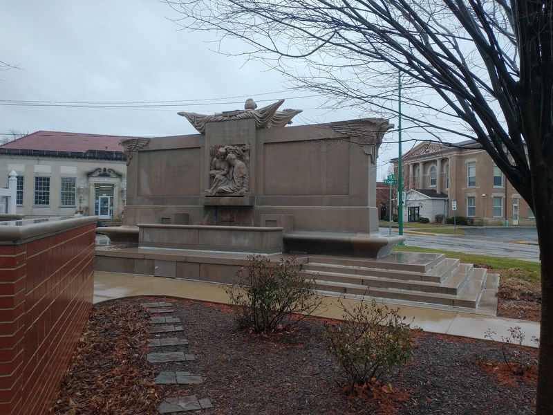
On South 3rd Street at Court Street, on the right when traveling north on South 3rd Street.
In Memoriam
U.S.S. Maine
Destroyed in Havana Harbor
February 15th 1898
This tablet is cast from metal recovered from the U.S.S. Maine — — Map (db m211664) HM WM
Fort Wayne business had a start on Duck Street, named for the 19th century Duck Creek that drained the area from the higher ground near Superior Street into the St. Mary’s River. Along Duck Creek in the 1840s and 50s stood the City Mills, one of the . . . — — Map (db m16997) HM
The Wabash & Erie Canal was instrumental in the construction of the first railways in Fort Wayne, which quickly became a railroading center in the Midwest. In 1852, along the canal at the present-day railroad elevation that borders the south edge of . . . — — Map (db m16996) HM
Around the turn of the century, the nationwide “City Beautiful” movement found local expression through the efforts of Charles Mulford Robinson and nationally known landscape architect George Kessler. Seeking to reclaim the natural beauty of our . . . — — Map (db m17034) HM
The confluence area of the Three Rivers was known to the native people since as early as the end of the last Ice Age, more than 10,000 years ago. As the glaciers melted and receded, they paused here creating a high point in the topography of the . . . — — Map (db m17064) HM
The concrete retention walls at the north end of the plaza will help downtown Fort Wayne withstand future flooding when the rivers rise. They were constructed where sandbaggers and volunteers worked during the flood of 1982 to build a dike to . . . — — Map (db m17061) HM
Architect Eric R. Kuhne was commissioned to design a flood control plan that would provide for a park and premier festival center. It could also serve as a model for flood control in other sections of the country. The Headwaters Park Commission was . . . — — Map (db m17037) HM
Near South Clinton Street (U.S. 27) 0.3 miles south of East 4th Street, on the right when traveling south. Reported damaged.
Headwaters Park has been created by the citizens of Fort Wayne through their donations, ideas, and labor as a means of flood control in the city. Earlier designs had a similar purpose. George Kessler's plan of 1912 envisioned a greenspace for . . . — — Map (db m197058) HM
On Towpath / Eagle Marsh Trail at Trail 1, on the right when traveling north on Towpath / Eagle Marsh Trail.
If you had walked along this path back in the 1840s, you might have seen some birds that you don’t see today. One might have been the greater prairie-chicken. First you might have heard a low-pitched call, like the sound of blowing across a . . . — — Map (db m225917) HM
Long before settlers appeared on the scene, the American Indian people here used the sandhill crane as a symbol for their tribe. Early British and American officials referred to the people we know as Miami as “Twightwees” in various . . . — — Map (db m17068) HM
Most often the rivers here brought prosperity. They are the reason humanbeings settled here; established a land portage to connect with the Wabash River system; and attracted the canal followed by rails, highways, industry, and homes. They brought . . . — — Map (db m17030) HM
The French built Fort St. Philippe (Fort Miamis) west of this area by 1722, to command the land portage here between the Maumee and Wabash Rivers. It was important to the French to protect the area in their political competition with the British as . . . — — Map (db m17067) HM
On Trail 1, 0.3 miles west of Towpath / Eagle Marsh Trail, on the left when traveling west.
The valley of the Little River, where you are standing now, was carved out about 14,500 years ago when the waters of Glacial Lake Maumee overtopped the Fort Wayne Moraine, a ridge composed of glacial sediment, unleashing a catastrophic flood. The . . . — — Map (db m225921) HM
On Towpath / Eagle Marsh Trail, on the right when traveling north.
In colonial times, a portage from the St. Marys River in Fort Wayne to the Wabash River in Huntington enabled a major French and Indian trade route to exist from Quebec on the St. Lawrence River to New Orleans on the Mississippi River. Later, the . . . — — Map (db m225163) HM
On S. Barr Street, on the left when traveling south.
Past this point flowed the Wabash and
Erie Canal begun at Fort Wayne in 1832
rad dedicated at Fort Wayne July 4, 1843.
m its final phase the canal ran from
Maumee Bay on Lake Erie, through
Fort Wayne and southwestward to
Lafayette and thence . . . — — Map (db m197327) HM
On Superior Street at Spy Run Avenue / Purple Heart Memorial Hwy (U.S. 27), on the left when traveling east on Superior Street.
Terminal point where French-Canadian boats, hollowed from 30-60 foot poplar logs, brought families and cargo up the Maumee River from Toledo and Detroit, and returned furs to Lake Erie in exchange for traders' supplies, from the late 1700's until . . . — — Map (db m16957) HM
On West Main Street at Growth Avenue, on the right when traveling west on West Main Street.
On February 22, 1832, ground was broken two blocks north for the canal, which would link Lake Erie at Toledo with the Ohio River at Evansville. Jordan Vigus, Canal Commissioner, Charles W. Ewing, Samuel Hanna, Elias Murray participated in the . . . — — Map (db m21045) HM
Near Rivergreenway, 0.1 miles east of Spy Run Avenue (U.S. 27), on the left when traveling east.
The Saint Mary's River and the St. Joesph River converge in Fort Wayne to form the Maumee River. The most important geographical feature of the area is the short distance overland between the Three Rivers system, which eventually flows to the . . . — — Map (db m239133) HM
Anchoring the southern edge of the Headwaters Park “Thumb” until circa 1874, the Wabash & Erie Canal’s importance to transportation to the western part of the United States and to the growth of Fort Wayne was substantial. Headwaters Park . . . — — Map (db m16985) HM
Near Rivergreenway east of Spy Run Avenue (U.S. 27), on the left when traveling east.
The Three Rivers Water Filtration Plant was constructed between 1931 and 1933 as a solution to persistent difficulties suffered by the growing city of Fort Wayne in obtaining a sufficient quantity of safe drinking water.
Before the 1870s, . . . — — Map (db m239135) HM
On W. Columbia Street, on the left when traveling west.
For nearly a century, the principal
business street of Fort Wayne, named for
Dana Columbia, hotel and canal boat operator.
Here was the terminal for passengers
and freight arriving and departing via
stagecoach and canal. Ground broken
for . . . — — Map (db m197141) HM
On Van Buren Street at Michaels Avenue, on the right when traveling north on Van Buren Street.
French built a palisaded fort on this strategic site in 1722; named Fort Saint Philippe des Miamis. One of three French forts built in what is now Indiana to protect French fur trade from encroaching English. First of five forts built over time . . . — — Map (db m241261) HM
On West Main Street at Rockhill Street, on the left when traveling west on West Main Street.
The Aqueduct
Carrying the Wabash and Erie Canal across the St. Marys River was located just north of the bridge about where the Nickle Plate Railroad crosses the river and was the playground and swimminghole for the West End Boys. Completed . . . — — Map (db m99093) HM
On East Superior Street, on the right when traveling east.
In 1852 John Brown, a stonemason, built this last remaining vestige of the early canal era in FortWayne.
A native of Glasgow, Scotland, Brown came by canal boat to Allen County in 1847 with his wife Mary. He and his Scottish business partner, . . . — — Map (db m100141) HM
On U.S. 24 at Harper Road, on the right when traveling east on U.S. 24.
Wabash and Erie Canal lock was discovered here June 1991 during excavation for highway construction. It was built 1838–1840 by Henry Lotz and named for lock keeper Joseph Gronauer. The rare, well-preserved timber-frame design lock measured . . . — — Map (db m2498) HM
On Broadway Street, on the right when traveling north.
Past this point flowed
the Wabash and Erie Canal
begun in 1832 and
dedicated July 4. 1843 at Fort Wayne.
In its final phase the canal
extended 459 miles
from Maumee Bay to Toledo,
through New Havens southwestward
to Layette and then to . . . — — Map (db m197133) HM
Near West North Washington Street at North Charles Street, on the right when traveling east.
Before You Is a Kaleidoscope of Flavors and Scents
Early settlers maintained an herb garden for four reasons:
Medicine, flavor for food, to provide scents for soap and for
fresh flowers as well as dried flowers for year-long . . . — — Map (db m163307) HM
Near West North Washington Street just east of Charles Street, on the right when traveling east.
The Bicentennial Garden was created in 2016 as a way for the Carroll
County Wabash & Erie Canal Association to celebrate the two
hundredth anniversary of the founding of the state of Indiana. With
a strong focus on blues and yellows, the . . . — — Map (db m163258) HM
Near West North Washington Street at North Charles Street, on the right when traveling east.
Blacksmith Shop
A Blacksmith is one who works with iron at a furnace or forge where
"black” metal, heated and wrought is formed by beating and hammering
into a desired shape. A "whitesmith” worked with light metals. . . . — — Map (db m163333) HM
On West North Washington Street at North Charles Street, on the right when traveling east on West North Washington Street.
Building A Home
Felhng 40 or so logs in the forest 15-26 inches in diameter for the sides and ends
the settler had only to add three or four shorter ones for the gables. Each end was
notched to both secure one log with the next and to . . . — — Map (db m163318) HM
Near West North Washington Street just east of Charles Street, on the right when traveling east.
A Canal Boat That Will Not Float?
The Playground Boat is most like the freight boat in the
above illustration. But this one has been changed to make it
fun for young people's imagination. It won't float in the Canal
but it will carry . . . — — Map (db m163259) HM
Near West North Washington Street at North Charles Street, on the right when traveling east.
A Variety of Bridges Solve Many Problems
When the Wabash & Erie Canal cut through an Indiana
wilderness, its 40 feet wide channel of water created
challenges for those who wished to cross from one side to
the other. Pedestrians, . . . — — Map (db m163312) HM
Near West North Washington Street at North Charles Street, on the right when traveling east.
Animals For Towing Canal Boats
During a time before motorized power, canal boats were
towed by horses or mules using heavy ropes of 100 feet or
more. On the Wabash & Erie Canal towpath, one animal or
more hitched in tandem, were led by a . . . — — Map (db m163350) HM
Near West North Washington Street just east of North Charles Street, on the right when traveling east.
Creating a Life in the Wilderness
The Canal Village is comprised of buildings constructed
during the canal era. The water in back of you is the only
remaining accessible and recreational watered segment of
the Wabash & Erie Canal in . . . — — Map (db m163315) HM
On County Road N 700 W north of County Road W 675 N, on the right when traveling north.
90 lots platted in 1836 on both sides of Wabash - Erie Canal lock.
A Post office in 1838 - 39. The lock passed canal boats into the river on the pool of the Great Dam at Pittsburg five miles below. The mules carried the towline across the . . . — — Map (db m35413) HM
On Bicycle Bridge Road, 0.1 miles west of West Monroe Street (Indiana Route 18), on the right when traveling east.
The Wabash & Erie Canal ran 468 miles from Toledo, Ohio to Evansville, Indiana, thus providing
access to New York and the East Coast via the Erie Canal and access to New Orleans and the Gulf of
Mexico via the Ohio and Mississippi . . . — — Map (db m163354) HM
Near West North Washington Street at North Charles Street, on the right when traveling east.
Surveying: A Canal could not proceed along the upper Wabash until title to Miami and Potawatomi lands were transferred to the State. At the 1826 Treaty of Paradise
Springs the title was conveyed.
A corps of U. S. engineers was sent to Fort . . . — — Map (db m163309) HM
On South Washington Street south of West Franklin Street, on the right when traveling south.
The City Beautiful. Platted in 1828 by General Samuel Milroy
on land donated as the county seat by William Wilson, was an
industrial center during boom days of the Indiana Canal era. — — Map (db m161449) HM
On W. North Washington Street, on the right when traveling east.
How Would You Like To Sit On A Log Bench All Day?
The structure before you depicts a one room log school house of 1834. If you
were between the ages of 5 and 21 in rural Indiana in the 1830s you would have
attended a one room school very . . . — — Map (db m163328) HM
On West North Washington Street at North Charles Street, on the right when traveling east on West North Washington Street.
Kitchen Vegetable Garden
As European settlers arrived via the canal and by wagon this region was still
a wilderness in the 1830s. It was essential for their survival to bring seeds and
root cuttings to start their gardens in this forest . . . — — Map (db m163319) HM
Near West North Washington Street just east of Charles Street, on the right when traveling east.
The Wabash & Erie Canal conference
and interpretive center before you
combines historic facades from 1850s
downtown Delphi.
J. H. Stewart Drugs, Callahan Boots and Lathrope
Bakery fill the middle of the block in this 1850s . . . — — Map (db m163275) HM
Near West North Washington Street at North Charles Street, on the right when traveling east.
Logs were part of the railroad trestle at Pittsburgh removed in the 1930s. They became a lakeside cottage on Freeman Lake known as "The Oaks". Logs were donated by the families of: Grantham, Israel and Goyer in 2019 — — Map (db m163338) HM
Near West North Washington Street at North Charles Street, on the right when traveling east.
Lewis T. Jones, a blacksmith, and his
wife Manerva arrived in Carroll County
in 1850, They disembarked from the Wabash
& Erie Canal at Lockport and two years later
settled in Jefferson Township. One of their
eight children who came with them . . . — — Map (db m163260) HM
Near West North Washington Street at North Charles Street, on the right when traveling east.
A New Spiritual Anchor at Canal Park
During the 1830s and 40s the Canal
transformed this region into a new cultural
and economic entity. This new era propelled
a now confident Delphi into the mid and late
19th century. It was now ready . . . — — Map (db m163314) HM
Near West North Washington Street at North Charles Street, on the right when traveling east.
Weaving for the Canal Homestead
If the woodsman's axe and the long rifle were first
in importance to the pioneer, the spinning wheel
and the loom would rank second. In colonial
America many families wove cloth for clothing.
bedding, . . . — — Map (db m163324) HM
On Road N 700 W north of Road W 675 N, on the right when traveling north.
Carrollton on the Wabash
The Mentzer Tavern was built in 1840 at the north end of the Carrollton Towing Path Bridge that crossed the Wabash River. Erected by Ignatius Mentzer and George Friday, it opened as a cooper shop where barrels were made . . . — — Map (db m35438) HM
Near West North Washington Street at North Charles Street, on the right when traveling east.
Carroll County Wabash & Erie Canal Inc.
wishes to convey its appreciation for the
contribution and vision of our friend and
neighbor, Duke Energy Foundation. The
completion of the Mule Barn creates a
major historic site for Canal Park and . . . — — Map (db m163351) HM
Near West North Washington Street just east of Charles Street, on the right when traveling east.
Prairie plants like those featured here grew along the canal's towpath.
Look for the featured plants as you walk the towpath.
Can You Picture It?
The canal landscape has changed over time.
The Canal Width. The canal . . . — — Map (db m163261) HM
Near Bicycle Bridge Road, 0.1 miles west of West Monroe Street (Route 16), on the left when traveling west.
Surrounded By Immense Water Power
Delphi Paper Mill: George Robertson came from Scotland and established a
small paper mill here in 1845. It was powered by Canal water leased by the
State and parallel to the Wabash River. Enoch Rinehart . . . — — Map (db m163361) HM
Near West North Washington Street just east of North Charles Street, on the right when traveling east.
Before Canals
The Wabash River illustrates how wilderness streams
served as highways beginning with the early French
explorers. Before the canal, rivers brought settlers
to new adventures and opportunities cutting through
unknown . . . — — Map (db m163279) HM
On County Road N 700 W north of County Road W 675 N, on the right when traveling north.
Front
The Wabash & Erie Canal meets the Wabash River
Carroll County Wabash & Erie Canal
Delphi, Indiana
See Photo #2:
1844 Timber Truss Bridge
The Wabash and Erie Canal authorities built the first bridge here in . . . — — Map (db m35445) HM
Near West North Washington Street at North Charles Street, on the right when traveling east.
Cooper Shop: An Ancient Craft
The Cooper trade is an old one which came to America in
the 1600s and was a leader in developing and introducing
machines to replace the handmade methods. Before modern
plastics and cardboard materials were . . . — — Map (db m163326) HM
Near West North Washington Street at North Charles Street, on the right when traveling east.
A New Home For The Depot
This restored train depot was
originally used by the Erie Line
in Leiters Ford, Indiana. Built
in the 1880s it symbolized a
new mode of competition for
canal travel. By the 1860s the
Canal fell into decline . . . — — Map (db m163345) HM
Near West North Washington Street at North Charles Street, on the right when traveling east.
Guard Lock Gates Keep The Canal Safe
Before you is a replica of a guard lock constructed of large cut
limestone blocks. Guard locks often had only one set of gates as
opposed to lift locks which always had two sets of lock gates.
The . . . — — Map (db m163339) HM
Near West North Washington Street at North Charles Street, on the right when traveling east.
A Small Construction Camp Shanty
This Canal worker's shanty is constructed of actual canal-era
timbers. Plain and simple, these temporary structures provided
for the workers - offering a place to sleep, argue, joke, gamble,
mediate and . . . — — Map (db m163337) HM
Near West North Washington Street at North Charles Street, on the right when traveling east.
Papermaking developed in China around 100 AD. The process is based on using any plant
fiber or cellulose based material which has been processed (beaten) and mixed with water.
Cotton, hemp and linen are commonly used. The hand dipping process . . . — — Map (db m163316) HM
On Road N 700 W north of Road W 675 N, on the left when traveling north.
Front
The Longest Canal in North America
Carroll County Wabash & Erie Canal
Delphi, Indiana
The Wabash & Erie Canal extended 468 miles
from Toledo, Ohio to Evansville, Indiana
On March 2, 1827, a Congressional land grant made . . . — — Map (db m35449) HM
On Bicycle Bridge Road, 0.1 miles west of West Monroe Street (Indiana Route 18), on the right when traveling east.
Great Place to Visit
Enjoy yourself, take your time, bring your camera and
your fishing tackle, watch the clouds reflected on the
Wabash, experience the spirit of a nineteenth century
downtown square, walk a tree lined trail along the . . . — — Map (db m163356) HM
Near West North Washington Street at North Charles Street, on the right when traveling east.
The Wabash & Erie Canal ran 468 miles from Toledo, Ohio to Evansville, Indiana, thus providing
access to New York and the East Coast via the Erie Canal and access to New Orleans and the Gulf of
Mexico via the Ohio and Mississippi . . . — — Map (db m163281) HM
On Bicycle Bridge Road just west of West Monroe Street (Indiana Route 18), on the left when traveling west.
Constructed 1832-1853, canal was
nation's longest, connecting Lake
Erie at Toledo with Ohio River at
Evansville. Key portion in Carroll
County included Deer Creek Lake
Dam, constructed 1838-1840 (1 mile
west). Various canal structures . . . — — Map (db m163353) HM
Constructed 1832-1853, canal was nation's longest, connecting Lake Erie at Toledo with Ohio River at Evansville. Key portion in Carroll County included Deer Creek Lake Dam, constructed 1838-1840 (1 mile west). Various canal structures are still in . . . — — Map (db m7540) HM
Near West North Washington Street just east of North Charles Street, on the right when traveling east.
Carroll County Wabash & Erie Canal, Inc.
Founded in 1974, in Delphi, Indiana, Carroll County Wabash & Erie Canal, Inc. is dedicated to the
preservation of the stretch of the Wabash & Erie Canal located in Delphi, Indiana. Approximately . . . — — Map (db m163280) HM
On Bicycle Bridge Road, 0.1 miles west of West Monroe Street (Indiana Route 18), on the right when traveling east.
Carroll County Wabash & Erie Canal, Inc.
Founded in 1974, in Delphi, Indiana, Carroll County Wabash & Erie Canal, Inc. is dedicated to the
preservation of the stretch of the Wabash & Erie Canal located in Delphi, Indiana. Approximately . . . — — Map (db m163355) HM
Near West North Washington Street at North Charles Street, on the right when traveling east.
Great Place to Visit
Enjoy yourself, take your time, bring your camera and
your fishing tackle, watch the clouds reflected on the
Wabash, experience the spirit of a nineteenth century
downtown square, walk a tree lined trail along the . . . — — Map (db m163306) HM
On Howard Street, on the right when traveling south.
Platted by Merkle, Kendall & Co.
in 1838 for side-cut canal traffic
and cheap water-power from the
summit level dam, Pittsburg had
grain warehouses, flouring mills,
oil and saw mills, wool carding
and fulling, foundry and machine
shops, . . . — — Map (db m163204) HM
The Little Turtle Waterway Plaza was conceived and built to: Provide public access to the Wabash River, Serve as the trailhead park for the future Lail system in Logansport and Cass County, Provide instruments to help interpret local history, and . . . — — Map (db m240889) HM
On North 5th Street at North Street, on the left when traveling north on North 5th Street.
Trade and emigration route from Lake Erie to Evansville. Completed through Logansport 1840. Followed Erie Avenue and 5th Street, crossing Eel River by wooden aqueduct. Abandoned about 1876. — — Map (db m35409) HM
On Jersey Avenue east of Ohio River Scenic Byway (Indiana Road 62), on the left when traveling east.
Nearby is site of former popular Ohio River regional recreation area known from 1880s as Fern Grove. David Rose expanded facilities in 1923 – including an amusement park and a swimming pool – and named it Rose Island. Major access was by car to . . . — — Map (db m206818) HM
On Tunnel Mill Road, on the right when traveling south.
John Work, born 1760 in Pennsylvania, came with family to Clark County, Indiana Territory circa 1804. He purchased land along Fourteen Mile Creek in 1805 and later acquired extensive property in the county. Federal-style brick home here built circa . . . — — Map (db m206815) HM
Near Patrol Road, 0.7 miles north of Collector Wells Road, on the right when traveling north.
Since the beginning of history, people have been drawn to the river for water, food and transportation.
1. The Earliest People Several archaeological sites at Charlestown reveal stories of temporary camps. Mounds in this region date from the . . . — — Map (db m206831) HM
On Ohio River Scenic Byway, 0.4 miles west of Main Street, on the left when traveling west.
By the Way: Lewis and Clark began their famous expedition from this area on October 26, 1803.
Almost 400 million years ago, during the Devonian age, future states Indiana and Kentucky were asleep beneath a warm tropical sea, located about . . . — — Map (db m206956) HM
On W. Winbourne Avenue at W Riverside Drive, on the right when traveling south on W. Winbourne Avenue.
River Navigation
The Dam - The huge concrete wall that you see is the McAlpine Dam. Its main function is to control water levels for navigation, but its unusual shape, an elongated Z, also provides water for the hydroelectric station while . . . — — Map (db m103853) HM
Near Mulberry Street south of West Maple Street, on the left when traveling south.
Howard's Shipyard, Barmore Shipyard, French Brothers and later the Sweeney Brothers Shipyard and Foundry all put Jeffersonville on the map as the premier builder of steamboats. Howard's Shipyard also built a number of the LSTs during World War II. . . . — — Map (db m186829) HM
On North Main Street at East Washinton Street, on the right when traveling north on North Main Street.
( Top has Insignia of the "Navy Club U.S.A." )
This memorial is erected to
revere, honor, and perpetuate
the memory of our departed Shipmates
Roy E. Boggess
Ship No. 11 — — Map (db m21430) WM
On Ohio River Scenic Byway (State Road 62) 0.2 miles west of East Hiawatha Heights, on the left when traveling west.
Captain Winfield Scott Paris piloted riverboats for 45 years, including many of the famous steamboats and paddlewheelers that navigated the Ohio River.
Captain Paris, born May 20, 1848 in Kentucky to Dabner Cosby and Mary ReynoldsParis, was one . . . — — Map (db m207102) HM
On Ohio River Scenic Byway (State Road 62) 0.2 miles west of East Hiawatha Heights, on the left when traveling west.
This town of Leavenworth was mainly known for two things, skiffs and buttons. In 1814, Zebulon Leavenworth laid out the town here because of the large fresh water spring at the base of the hill.
Two years later, Daniel Lyon had set up a boat . . . — — Map (db m207098) HM
On Ohio River Scenic Byway (State Road 62) 0.2 miles west of East Hiawatha Heights, on the left when traveling west.
Construction of locks and dams on the Ohio began in Louisville with a canal around the Falls of the Ohio, a major obstacle to boat traffic, in 1825. The Louisville and Portland Canal was privately financed, and completed in 1830. Constructed by . . . — — Map (db m207101) HM
Near Ohio River Scenic Byway (State Road 62) 0.2 miles west of East Hiawatha Heights, on the left when traveling west.
Button making was once big business in this area. There were 14 local species of mussels used for buttons. Today most are gone and some are extinct.
The 1910 Census of 166 families in Leavenworth showed 32 men worked as button-cutters, 4 were . . . — — Map (db m207100) HM
On State Road 58 west of State Road 57, on the right when traveling east.
A canal from Terre Haute to Evansville authorized 1846. Maysville Division along White River was over 23 miles long from Newberry through Owl Prairie (now Elnora) to Maysville; part of it paralleled what is now S.R. 57. Contracts were let June . . . — — Map (db m23203) HM
On Lesko Park Bike Path, 0.3 miles south of John Street, on the right when traveling north.
Ephraim Morrison Canoe at Aurora Landing •
Phillip Craig •
Capt. Marcus Colling •
Frank Klopp Horse Powered until 1918 then built the Etta Belle •
Van Landingham Etta Belle 1935 to 1936 • . . . — — Map (db m201077) HM
On Water Street (State Road 56) at 3rd Street, on the right when traveling north on Water Street.
Legend has it that a ferry has operated near this location close to the mouth of Hogan Creek since 1802. The early ferries were powered by two horses walking on treadmills connected to a paddle wheel. The relationship between the small town of . . . — — Map (db m66904) HM
On Judiciary Street at 2nd Street, on the right when traveling east on Judiciary Street.
On the bank of the Ohio near here, opposite the Eagle Hotel, Pinkney James
built the steamboat Clinton 1823-24. The launching July 4, 1824 occasioned a great celebration and firing of cannon. — — Map (db m172613) HM
On 5th Street west of Dewers Street, on the left when traveling west.
Hillforest
Following the Panic of 1837, Philadelphia Distiller Thomas Gaff and his brothers James and John sought new opportunity in southern Indiana, where in 1843 they established T. & J.W. Gaff & Co. Distillery in Aurora, Indiana. Soon . . . — — Map (db m201095) HM
On Riverview Drive south of East Laughery Creek Road, on the right when traveling south.
Architect William Tinsley of Cincinnati was known throughout the Midwest for his outstanding landscape designs, including Fountain Square in Cincinnati. Riverview Cemetery on the banks of the Ohio is a splendid example of his work. It is reflective . . . — — Map (db m222258) HM
Plaque One
Captain Samuel C. Vance
Our Founder Plaque Two
In memory of Captain Vance and the pioneer families who endured the hardships of flatboat travel to reach this place in the wilderness.
They lived in log cabins . . . — — Map (db m20604) HM
On Green Boulevard (U.S. 50) at Main Street, on the right when traveling east on Green Boulevard.
Born in Lawrenceburg, became a famous engineer who built the Eads Bridge arched over the Mississippi at St. Louis and jetties at New Orleans. During the Civil War President Lincoln commissioned him to design and build ironclad gunboats for the Union . . . — — Map (db m66910) HM
On Walnut Street at High Street, on the right when traveling north on Walnut Street.
1802 - - Village of Lawrenceburgh founded in the Wilderness by Capt. Samuel C. Vance
Commerce and travel are via the Ohio River. Pioneers
constructed flatboats to carry goods to New Orleans
Markets. The “Kaintucks” . . . — — Map (db m22029) HM
On East High Street at Elm Street, on the left when traveling south on East High Street.
c. 1820 Before the levee was built, Elm Row continued down the river to the city wharf — now under water.
1836 Indiana appropriates $1,400,000 to begin construction on Whitewater Canal linking the National Rd to Ohio River.
1837 . . . — — Map (db m187437) HM
On West High Street east of Maple Street, on the right when traveling east.
Renowned engineer James B. Eads,
who was born in Lawrenceburg in
1820, lived in this home until his
family moved to St. Louis in 1833.
Eads was a self-taught engineer
and is known for designing the
Bridge across the Mississippi River
in 1869. . . . — — Map (db m222819) HM
On S. State Street at Campbell Road, on the right when traveling south on S. State Street.
(Front Side)
The Whitewater Canal and the Cincinnati and Whitewater Canal joined in Harrison to provide better access to Cincinnati markets and Ohio River. Indiana Internal Improvement Act 1836 authorized Whitewater Canal; completed from . . . — — Map (db m66869) HM
Near West Kilgore Avenue (Indiana Route 32) just east of West 2nd Street, on the left when traveling east.
In remembrance
of the Delaware County Civil War Veterans / POWS of the 9th Cavalry, 121st Regiment — especially to those who lost their lives when the steamboat Sultana exploded, April 27, 1865 on the Mississippi River, 7 miles north of . . . — — Map (db m141230) HM
On County Road 625 at County Road 1167, on the right when traveling south on County Road 625.
One of the oldest organized settlements in Delaware County, Smithfield was platted by David Stout and
William Duncan March 12, 1830. Its position on White River was considered advantageous as a trading point, and it thrived as such until the first . . . — — Map (db m141162) HM
Near South Elkhart Avenue south of Nibco Parkway, on the right when traveling north.
Dams have been used throughout the United States for a variety of reasons such as flood control and power generation. However, dams can greatly impact a river's ecology in three major ways: fish migration, habitat destruction, and water . . . — — Map (db m236150) HM
East from this point, along the "Elkheart" River were located the wharves where produce and merchandise to and from the village of "Elkheart", 1835 to 1851, was carried by Keel and Steamboat. — — Map (db m61185) HM
Near Nibco Parkway just south of East Lexington Avenue, on the right when traveling south.
Elkhart’s rise as an early industrialized community can be tied directly to its rivers and the power they provided. Water flowing through a system of dams and raceways, known as hydraulics, generated the power for many types of industry.
In . . . — — Map (db m236109) HM
Near Nibco Parkway just north of South Clark Street, on the right when traveling south.
Here in Elkhart, raceways along the St. Joseph and Elkhart Rivers powered a series of early mills and factories in the 1800's. The last water-powered mill ran until 1955.
🅐 The headrace, formerly located on this site, ran parallel . . . — — Map (db m236110) HM
Near Riverwalk Drive south of East Sycamore Street, on the right when traveling north.
Transporting Goods on the Rivers
Long before the railroad came to the area, the settlers relied on the rivers to transport their products to other markets. This area was fortunate to have two navigable rivers. The smaller Elkhart River flowed . . . — — Map (db m236112) HM
304 entries matched your criteria. The first 100 are listed above. Next 100 ⊳