6945 entries match your criteria. Entries 201 through 300 are listed.⊲ Previous 100 — Next 100 ⊳
Charity & Public Work Topic
By Denise Boose, January 2, 2010
Plaza Fire House and Marker
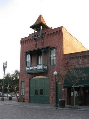
| 201 ► California, Los Angeles County, Los Angeles, Chinatown — 730 — Plaza Fire House — |
| On Los Angeles Street. | |||
| 202 ► California, Los Angeles County, Los Angeles, Downtown Los Angeles — Christine Sterling — |
| Near Paseo de la Plaza at Olvera Street. | |||
| 203 ► California, Los Angeles County, Los Angeles, Downtown Los Angeles — Luc Robitaille — |
| On Chick Hearn Court just west of Figueroa Street, on the left when traveling west. | |||
| 204 ► California, Los Angeles County, Los Angeles, Granada Hills — Granada Hills Masonic Temple — |
| On Rinaldi Street just east of Hayvenhurst Avenue, on the left when traveling east. | |||
| 205 ► California, Los Angeles County, Los Angeles, Griffith Park — Amir’s Garden — Since 1971 — Amir Dialameh, 1932-2003 — |
| Near Griffith Park Drive at Mineral Wells Road. | |||
| 206 ► California, Los Angeles County, Los Angeles, Griffith Park — 942 — Griffith Park — |
| On Crystal Springs Drive at Los Feliz Boulevard, on the right when traveling north on Crystal Springs Drive. | |||
| 207 ► California, Los Angeles County, Los Angeles, Griffith Park — Los Angeles River — Autry Museum — |
| On Western Heritage Way at Zoo Drive, on the left when traveling south on Western Heritage Way. | |||
| 208 ► California, Los Angeles County, Los Angeles, Griffith Park — Spirit of the CCC — Honoring Those Who Served in the Civilian Conservation Corps — 1933 - 1942 — |
| Near Zoo Drive, 0.1 miles east of Forest Lawn Drive. | |||
| 209 ► California, Los Angeles County, Los Angeles, Highland Park — 284 — Highland Park Ebell Club — |
| On Avenue 57 south of Figueroa Street, on the left when traveling south. | |||
| 210 ► California, Los Angeles County, Los Angeles, Hollywood — 421 — Hollywood Reservoir — Mulholland Dam — |
| Near Weidlake Drive, 0.4 miles north of Deep Dell Place, on the left when traveling north. | |||
| 211 ► California, Los Angeles County, Los Angeles, Hollywood — 45 — The Johnny Grant Building — Hollywood Historic Site — 7018 - 7024 Hollywood Blvd. — |
| On Hollywood Boulevard west of Orange Drive, on the left when traveling west. | |||
| 212 ► California, Los Angeles County, Los Angeles, Lake View Terrace — Paradise Ranch — Cecil B. DeMille — 1963 — |
| On Gold Creek Road, 1 mile east of Little Tujunga Canyon Road, on the left when traveling east. | |||
| 213 ► California, Los Angeles County, Los Angeles, Mid-Wilshire — 250 — The Ebell of Los Angeles — |
| On Lucerne Boulevard at Wilshire Boulevard, on the right when traveling south on Lucerne Boulevard. | |||
| 214 ► California, Los Angeles County, Los Angeles, North Hollywood — The Great Wall of Los Angeles — |
| On Coldwater Canyon Avenue at Oxnard Street, on the left when traveling north on Coldwater Canyon Avenue. | |||
| 215 ► California, Los Angeles County, Los Angeles, Northridge — Carl Dentzel — Northridge Pioneer — Cordillera del Norte — |
| Near Nordhoff Street at Wilbur Avenue, on the right when traveling east. | |||
| 216 ► California, Los Angeles County, Los Angeles, Pacoima — Pacoima Neighborhood Mural — |
| Near Van Nuys Boulevard at Oneida Avenue, on the right when traveling north. | |||
| 217 ► California, Los Angeles County, Los Angeles, Sherman Oaks — Melhorn Overlook — Mulholland Scenic Parkway — |
| On Mulholland Drive, 0.3 miles east of Benedict Canyon Drive, on the left when traveling east. | |||
| 218 ► California, Los Angeles County, Los Angeles, South Los Angeles — 851 — 28th Street YMCA — |
| On 28th Street west of Central Avenue, on the left when traveling west. | |||
| 219 ► California, Los Angeles County, Los Angeles, South Los Angeles — California African American Museum — |
| On Figueroa Street at State Drive, on the right when traveling south on Figueroa Street. | |||
| 220 ► California, Los Angeles County, Los Angeles, South Los Angeles — 241 — Casa de Rosas/Sunshine Mission — |
| On Hoover Street at Adams Boulevard, on the right when traveling north on Hoover Street. | |||
| 221 ► California, Los Angeles County, Los Angeles, South Los Angeles — Exposition Park and USC — |
| Near Trousdale Parkway. | |||
| 222 ► California, Los Angeles County, Los Angeles, South Los Angeles — First Meeting of the USC Board of Trustees — University of Southern California — |
| On Trousdale Parkway at Hellman Way, on the right when traveling north on Trousdale Parkway. | |||
| 223 ► California, Los Angeles County, Los Angeles, South Los Angeles — Leon “Ted” Garr Square — |
| On Vermont Avenue at Gage Avenue, on the right when traveling north on Vermont Avenue. | |||
| 224 ► California, Los Angeles County, Los Angeles, South Los Angeles — Public Service — USC — University of Southern California — |
| On Trousdale Parkway at West 34th Street, on the left when traveling north on Trousdale Parkway. | |||
| 225 ► California, Los Angeles County, Los Angeles, South Los Angeles — 139 — Shrine Auditorium & Expo Center — |
| On West Jefferson Boulevard at Royal Street, on the left when traveling west on West Jefferson Boulevard. | |||
| 226 ► California, Los Angeles County, Los Angeles, South Los Angeles — Student Musical Traditions — USC — University of Southern California — |
| Near West 34th Street. | |||
| 227 ► California, Los Angeles County, Los Angeles, Sylmar — Dexter Park — |
| On Dexter Park Road, 0.2 miles south of Kagel Canyon Road, on the right when traveling south. | |||
| 228 ► California, Los Angeles County, Los Angeles, Van Nuys — Ernani Bernardi Plaza — |
| Near Sylmar Avenue south of Sylvan Street, on the right when traveling south. | |||
| 229 ► California, Los Angeles County, Mount Wilson, Angeles National Forest — Vetter Mountain Fire Lookout — |
| Near Vetter Mountain Road, 2 miles west of Angeles Crest Highway (California Route 2). | |||
| 230 ► California, Los Angeles County, Pasadena, Old Pasadena — First Salvation Army Meeting — |
| On Miller Alley at West Colorado Boulevard, on the right on Miller Alley. | |||
| 231 ► California, Los Angeles County, San Gabriel — Ramona Museum of California History — Ramona Parlor No. 109 Hall — |
| On South Mission Drive north of Santa Anita Street, on the left when traveling north. | |||
| 232 ► California, Los Angeles County, South Pasadena — 10 — Carnegie Library — South Pasadena — |
| On El Centro Street at Diamond Avenue, on the right when traveling east on El Centro Street. | |||
| 233 ► California, Marin County, San Anselmo — The Log Cabin — |
| On Veterans Place near San Francisco Boulevard. | |||
| 234 ► California, Marin County, Tiburon — Angel Island — |
| 235 ► California, Marin County, Tiburon — Shapero Bridge — |
| 236 ► California, Mariposa County, Fish Camp — Sustaining the Mariposa Grove — Mariposa Grove of Giant Sequoias — Yosemite National Park — |
| Near Mariposa Grove Road, 2.1 miles east of Wawona Road (California Route 41). | |||
| 237 ► California, Merced County, Gustine — Harry P. Schmidt Building — |
| Near 2nd Avenue near West Avenue. | |||
| 238 ► California, Merced County, Los Banos — Henry Miller — July 21, 1827 - October 14, 1916 — |
| On H Street at 6th Street, on the right when traveling west on H Street. | |||
| 239 ► California, Mono County, Bodie — Return to Bodie — |
| On Bypass Road at California Route 270, on the right when traveling west on Bypass Road. | |||
| 240 ► California, Mono County, Bridgeport — Poor Farm — |
| On U.S. 395 at Green Creek Road, on the right when traveling south on U.S. 395. | |||
| 241 ► California, Mono County, Lee Vining — West Portal — |
| On Viewpoint Road, 0.2 miles east of U.S. 395, on the right when traveling east. | |||
| 242 ► California, Napa County, Napa — Dave Cavagnaro Circus Plaza — |
| Near Third Street. | |||
| 243 ► California, Napa County, Yountville — Veterans Home of California — |
| On California Drive, on the left when traveling north. | |||
| 244 ► California, Nevada County, Grass Valley — 855 — Mount Saint Mary’s Convent and Academy — |
| On South Church Street when traveling south. | |||
| 245 ► California, Nevada County, Nevada City — Malakoff Diggins Clampicnic Area — |
| On North Bloomfield Road at Relief Hill Road, on the left when traveling east on North Bloomfield Road. | |||
| 246 ► California, Nevada County, Nevada City — Nevada Hose Co. No. 1 — |
| On Main Street, on the right when traveling west. | |||
| 247 ► California, Nevada County, Nevada City — Pennsylvania Engine Co. No. 2 — January 14, 1861 — |
| On Broad Street, on the right when traveling west. | |||
| 248 ► California, Nevada County, Norden — 16c — Cal Lodge — |
| On Donner Pass Road, on the right when traveling east. | |||
| 249 ► California, Orange County, Anaheim, Northeast Anaheim — Block by Block — |
| Near East Jackson Avenue. | |||
| 250 ► California, Orange County, Anaheim, Northeast Anaheim — Block by Block — |
| Near East Frontera Street. | |||
| 251 ► California, Orange County, Brea — 3 — Brea American Legion Building — |
| On Brea Boulevard at Elm Street, on the right when traveling south on Brea Boulevard. | |||
| 252 ► California, Orange County, Dana Point — The William C. Steinriede North Creek Stormwater Diversion Project — |
| On Dana Point Harbor Dr., on the right when traveling south. | |||
| 253 ► California, Orange County, Huntington Beach — Ted W. Bartlett — Mayor 1946 to 1948 — Councilman Twenty Years — |
| Near Beach Boulevard north of Adams Avenue, on the right when traveling north. | |||
| 254 ► California, Orange County, Mission Viejo — Celebration Garden — |
| Near Via Florecer. | |||
| 255 ► California, Orange County, Mission Viejo — Library Rose Garden — |
| Near Civic Center. | |||
| 256 ► California, Orange County, Mission Viejo — Mission Viejo — Make Volunteering you Mission — |
| Near Marguerite Parkway. | |||
| 257 ► California, Orange County, Mission Viejo — Mountain Wall — |
| Near Jeronimo Road east of Via San Fernando, on the right when traveling east. | |||
| 258 ► California, Orange County, Newport Beach — Roger Seitz — 1937-1995 — |
| Near Newport Center Drive, on the right when traveling north. | |||
| 259 ► California, Orange County, Orange, Northeast Anaheim — Steve Ambriz Memorial Park — |
| Near Riverbend Parkway. | |||
| 260 ► California, Orange County, San Clemente — City of San Clemente Lifeguards — 1931-2006 — Lifeguards — |
| Near Avenida Victoria north of Monterey Lane, on the left when traveling north. | |||
| 261 ► California, Orange County, San Juan Capistrano — 52 — San Juan Elementary School Site — |
| On El Camino Real when traveling north. | |||
| 262 ► California, Orange County, San Juan Capistrano — The Capistrano Depot — A Completed Dream and a Vision Fulfilled — Honoring Pete and Jim Tyson — |
| On Verdugo Street, on the right when traveling south. | |||
| 263 ► California, Orange County, Yorba Linda — Roland E. Bigonger — 1926-1997 — |
| On Parkside Dr., on the right when traveling east. | |||
| 264 ► California, Placer County, Auburn — Gietzen Fire Station — |
| On Sacramento Street near Auburn Folsom Road, on the right when traveling south. | |||
| 265 ► California, Placer County, Lincoln — Fleming Building — |
| On 5th Street, on the right when traveling west. | |||
| 266 ► California, Placer County, Rocklin — Rocklin Hose Company No. 1 — |
| On Front Street near B Street. | |||
| 267 ► California, Placer County, Roseville — Carnegie Museum — |
| On Lincoln Street at Pleasant Street, on the left when traveling west on Lincoln Street. | |||
| 268 ► California, Placer County, Tahoe City — 797 — William B. Layton Park — |
| On West Lake Boulevard (State Highway 89) west of North Lake Boulevard (State Highway 28), on the right when traveling north. | |||
| 269 ► California, Plumas County, Cromberg — Vardanega Spring — |
| On Mt. Tomba Road, on the right when traveling south. | |||
| 270 ► California, Plumas County, Portola — Western Pacific 106 "Charles O. Sweetwood" — Business Observation Passenger Car — |
| Near Western Pacific Way, 0.2 miles west of Main Street. | |||
| 271 ► California, Plumas County, Portola — Western Pacific Railroad 805-A — California Zephyr Passenger Locomotive — |
| Near Western Pacific Way, 0.2 miles west of Main Street. | |||
| 272 ► California, Riverside County, Banning — 60 — Banning Woman's Club Clubhouse — |
| On West Hays Street at North 2nd Street, on the right when traveling west on West Hays Street. | |||
| 273 ► California, Riverside County, Highgrove — 24 — Highgrove Hydroelectric Plant — |
| On Iowa Avenue at Spring Street, on the right when traveling south on Iowa Avenue. | |||
| 274 ► California, Riverside County, Indio — 116 — Dr. June Robertson McCarroll — |
| On Indio Boulevard east of Smurr Street, on the right when traveling south. | |||
| 275 ► California, Riverside County, Palm Springs — Charlie Farrell — Bronze created by Artist/Actor George Montgomery — Dedicated December 3, 1999 — |
| On Kirk Douglas Way, on the right when traveling south. | |||
| 276 ► California, Riverside County, Palm Springs — 36 — Owen Coffman Post #519 Palm Springs American Legion — Architects: Albert Frey & John Porter Clark — Built in 1948, Late Modern — |
| On North Belardo Road, on the right when traveling north. | |||
| 277 ► California, Riverside County, Palm Springs — 123 — The O'Donnell Golf Course — |
| On N Belardo Rd., on the right when traveling south. | |||
| 278 ► California, Riverside County, Palm Springs — The Wilderness Before You — This wilderness region comprises nearly 14,000 acres of rugged, wild beauty. — |
| Near Tram Way. | |||
| 279 ► California, Riverside County, Palm Springs — Wilderness Preservation — In wilderness, people are visitors who do not remain. — |
| Near Tram Way. | |||
| 280 ► California, Riverside County, Riverside — University Theater — |
| Near West Campus Drive south of University Avenue, on the right when traveling north. | |||
| 281 ► California, Riverside County, Riverside, Downtown Riverside — Booker Taliaferro Washington — |
| Near Mission Inn Avenue. | |||
| 282 ► California, Riverside County, Riverside, Downtown Riverside — Riverside County Courthouse — County of Riverside — Historical Marker — |
| Near Main Street. | |||
| 283 ► California, Riverside County, Riverside, Downtown Riverside — 2 — Riverside County Courthouse — 1903 — |
| Near Main Street. | |||
| 284 ► California, Riverside County, Riverside, Downtown Riverside — This Olive Tree — |
| On Orange Street, on the right when traveling south. | |||
| 285 ► California, Riverside County, Temecula — Patricia H. Birdsall — Temecula Resident — City Council Member & Mayor — |
| Near Deer Hollow Way, 0.1 miles north of Pechanga Parkway (County Road 16), on the left when traveling north. | |||
| 286 ► California, Sacramento County, Elk Grove — 817 — Site of the First County Free Library Branch in California — |
| 287 ► California, Sacramento County, Folsom — Folsom Dam Improvements — Promoting Public Safety for the Sacramento Region — |
| Near East Natoma Street. | |||
| 288 ► California, Sacramento County, Sacramento, Central Business District — Bishop Alfonso Gallegos — |
| On 11th Street north of Kayak Alley, on the right when traveling north. | |||
| 289 ► California, Sacramento County, Sacramento, Central Business District — California Firefighters Memorial — |
| 290 ► California, Sacramento County, Sacramento, Central Business District — 614 — Leland Stanford House — |
| 291 ► California, Sacramento County, Sacramento, Central Business District — Sisters of Mercy — |
| 292 ► California, Sacramento County, Sacramento, Central Business District — Sisters of Mercy — Arrival in Sacramento, October 2, 1857 — |
| 293 ► California, Sacramento County, Sacramento, Midtown — Naomi Anderson — 19th Amendment Outdoor Museum — |
| On 19th Street at K Street, on the right when traveling north on 19th Street. | |||
| 294 ► California, Sacramento County, Sacramento, Old Sacramento — Generous Souls — |
| Near K Street at Interstate 5, on the right when traveling east. | |||
| 295 ► California, Sacramento County, Sacramento, Old Sacramento — Historic Street Lights — |
| Near Front Street at 'O' Street. | |||
| 296 ► California, Sacramento County, Sacramento, Old Sacramento — The Land Legacy — |
| Near K Street at Interstate 5, on the right when traveling east. | |||
| 297 ► California, Sacramento County, Sacramento, Old Sacramento — The Sisters of Mercy — |
| Near K Street at Interstate 5, on the right when traveling east. | |||
| 298 ► California, Sacramento County, Sacramento, Poverty Ridge — Site of the Ridge Home - Sacramento's First Mercy Hospital — |
| On 23rd Street south of Q Street, on the left when traveling north. | |||
| 299 ► California, Sacramento County, Sacramento, Southwestern Sacramento — Margaret Rhodes Crocker — 1822 – 1901 — Wife of Edwin Bryant Crocker — |
| Near Broadway, on the right when traveling west. | |||
| 300 ► California, Sacramento County, Sacramento, Southwestern Sacramento — Old Masonic Cemetery — |
6945 entries matched your criteria. Entries 201 through 300 are listed above. ⊲ Previous 100 — Next 100 ⊳