By Mark Hilton, September 25, 2022
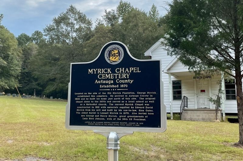
Myrick Chapel with cemetery on far left upper corner and marker.
| On County Road 99 north of County Road 68W, on the right when traveling north. |
| On Alabama Route 14, 0.4 miles west of County Road 9, on the right when traveling west. |
| On East 4th Street at South Chestnut Street, on the right when traveling east on East 4th Street. |
| On East 3rd Street at South Chestnut Street, on the right when traveling east on East 3rd Street. |
| On East Sixth Street, 0.4 miles east of North Northington Street, on the right when traveling west. |
| On Dosterville Road, 1.5 miles west of South Memorial Drive (U.S. 31), on the left when traveling west. |
| On Rocky Mount Road, 1.1 miles north of Cobbs Ford Road (U.S. 82), on the right when traveling north. |
| On East 4th Street at South Washington Street, on the right when traveling east on East 4th Street. |
| On County Road 21 south of County Road 20, on the right when traveling south. |
| On Courthouse Square (U.S. 31) at Hand Avenue, on the left when traveling west on Courthouse Square. |
| On Main Street (County Road 98) at Magnolia Avenue, on the right when traveling north on Main Street. |
| Near Dixie Graves Parkway (State Highway 180) when traveling west. |
| On Alabama Route 180 east of Gasque Lane, on the right when traveling west. |
| On Old Stage Road north of Alabama Route 59, on the left when traveling north. |
| On Alabama Route 131 at Dennis Road, on the left when traveling west on State Route 131. |
| On U.S. 82 at County Route 79, on the right when traveling east on U.S. 82. |
| On John Scott Road near Bethel Road, on the left when traveling south. |
| On South Midway Street, on the right when traveling south. |
| On Bowden Road, on the right when traveling west. |
| On Alabama Route 51 north of Clio Short Road, on the right when traveling north. |
| Near Alabama Route 51 north of Clio Short Road, on the right when traveling north. |
| On Alabama 51 (Alabama Route 51) 0.1 miles north of Clio Short Road, on the right when traveling north. |
| On East Barbour Street (U.S. 82) at South Eufaula Avenue (U.S. 431), on the right when traveling east on East Barbour Street. |
| On East Barbour Street (U.S. 82) at South Randolph Street, on the right when traveling west on East Barbour Street. |
| On North Randolph Avenue. |
| On South Eufaula Avenue (U.S. 431), on the right when traveling south. Reported missing. |
| On Woody Johnson Road east of County Road 79, on the left when traveling east. |
| On Springhill Road (County Road 89), on the right when traveling west. |
| On County Road 89 west of County Road 49, on the left when traveling west. |
| On Montevallo Road (State Highway 25) at County Road 62, on the left when traveling west on Montevallo Road. |
| On College Street at Church Street, on the right when traveling north on College Street. |
| On County Road 36, 0.1 miles north of New Home Church Road, on the right when traveling north. |
| On U.S. 29 just north of Twin Trail, on the right when traveling south. |
| On Fitzpatrick Road, 0.5 miles north of Alabama Route 110, on the right when traveling north. |
| On Old Troy Road, on the left when traveling west. |
| On Main Street, on the right when traveling south. |
| On Railroad Street, on the right when traveling west. |
| On County Road 14, 1.3 miles west of County Road 15, on the left when traveling west. |
| On State Highway 223 at County Road 22, on the left when traveling south on State Highway 223. |
| On Blackmon Street (U.S. 82) at Prairie Street, on the right when traveling west on Blackmon Street. |
| On Nickquenum Road, 2 miles south of Kirkville Road (County Road 75), on the left when traveling south. |
| Near Oakey Street Road at Halso Mill Road (County Route 59), on the right when traveling north. |
| On East 10th Street west of Kirkwood Avenue, on the left when traveling east. |
| On East 10th Street west of Leighton Avenue, on the left when traveling east. |
| On Quintard Avenue (U.S. 431), on the right when traveling north. |
| On East D Street at South Christine Avenue, on the left when traveling east on East D Street. |
| On Quintard Avenue (U.S. 431) at East 18th Street, on the right when traveling south on Quintard Avenue. |
| On West 17th Street at Cooper Avenue, on the right when traveling west on West 17th Street. |
| On Quintard Avenue (U.S. 431) at East 13th Street, on the right when traveling north on Quintard Avenue. |
| On Clinton Street Southeast, on the right when traveling west. |
| On Chinabee Avenue Southeast at Ladiga Street Southeast, on the right when traveling north on Chinabee Avenue Southeast. |
| On University Circle west of North Pelham Road (State Highway 21), on the right. |
| On Ladiga Street Southeast at Church Avenue Southeast, on the right when traveling east on Ladiga Street Southeast. |
| On East Ladiga Street, on the left when traveling west. |
| On North Main Street at Alabama Street on North Main Street. |
| On 5 Points Fredonia Road (County Road 222) east of County Road 267, on the right when traveling east. |
| On 1st Street Southeast at 2nd Avenue Southeast, on the right when traveling north on 1st Street Southeast. |
| On Country Club Road, 1.6 miles west of County Road 210, on the left when traveling west. |
| On U.S. 431 near County Road 23, on the right when traveling north. |
| On Boulevard at Scott Street, on the right when traveling south on Boulevard. |
| On West Main Street at Watson Drive, on the right when traveling west on West Main Street. |
| On County Route 33 at County Route 29, on the left when traveling south on County Route 33. |
| On County Route 458, on the right when traveling north. |
| On Railroad Street north of Main Street (State Route 22), on the left when traveling north. |
| On Alabama 22 at County Road 45, on the right when traveling south on Alabama 22. |
| Near County Road 45, 0.3 miles west of State Route 22, on the right when traveling north. |
| On County Road 59, 0.1 miles south of U.S. 31, on the right when traveling south. |
| On Little Drive (Little Place Cemetery Drive), 0.2 miles east of Ararat Road (County Route 23), on the left when traveling east. |
| Near Tuscahoma Road (County Route 43) 0.1 miles south of County Route 27, on the right when traveling south. |
| On Ararat Road (County Route 23) 7.2 miles north of Pleasant Hill Road, on the right when traveling east. |
| On Barlow Bend Road, 0.2 miles north of Madison Road (Route 33), on the left when traveling north. |
| On Ulcanush Lane, 0.1 miles north of Alabama Route 69, on the right when traveling north. |
| On Main Street Circle west of Main Street South, on the right when traveling west. |
| On Davis Avenue East east of East Front Street. |
| On West Bend Road (County Route 31) north of Jamestown Lane, on the right when traveling north. |
| On U.S. 84 at County Road 22, on the right when traveling west on U.S. 84. |
| On Main Street at Rickwood Drive, on the left when traveling east on Main Street. |
| On Winn Road (County Road 3) 0.7 miles north of Zimco Road (Route 23), on the right when traveling north. |
| On 1st Avenue (Alabama Route 9) 0.1 miles north of 5th Street East, on the right when traveling north. |
| On Cheaha Road (Alabama Route 49) at Nichols Street, on the right when traveling north on Cheaha Road. |
| On County Route 639 at County Route 640, on the right when traveling west on County Route 639. |
| On Davis Street, on the left when traveling west. |
| On South Main Street, on the right when traveling north. |
| On Alabama Route 27, on the right when traveling south. |
| On Alabama Route 51, on the left when traveling south. |
| On Mt. Pleasant Road (County Road 66) 0.3 miles east of County Line Road (County Road 48), on the right when traveling east. |
| On Main Street, 0.1 miles south of 1st Street, on the right when traveling south. |
| On County Line Road (Alabama Route 99) 0.2 miles north of Bethel Cemetery Road, on the left when traveling north. |
| On Old Hwy 20 east of Morgan Drive, on the right when traveling east. |
| On South Wilson Dam Road, on the right when traveling south. |
| On South Main Street at 4th Street, on the right when traveling south on South Main Street. |
| On East 4th Street at North Broad Street, on the right when traveling east on East 4th Street. |
| On North Dickson Street at East 3rd Street, on the right when traveling north on North Dickson Street. |
| On County Road 6, 0.2 miles west of County Road 43, on the right when traveling west. |
| On Rural Street at Williams Avenue, on the right when traveling west on Rural Street. |
19475 entries matched your criteria. The first 100 are listed above.
Next 100 ⊳