[English] The Emergency Swing Bridge Dam was built by the Dominion Bridge company of Montreal in 1896. The dam was modeled on the American Sault Canal dam, but the Canadian design was modified and the structure built entirely of steel. . . . — — Map (db m198477) HM
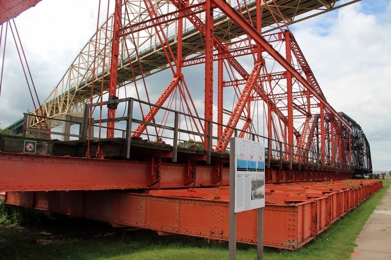
[English] You are standing beside the world's last Emergency Swing Dam. Only nine of these structures were ever built. Only this one was put to the ultimate test under emergency conditions.
In a 1909 emergency, this dam was swung across . . . — — Map (db m198462) HM
[English] This steel structure looks like a bridge, but it is actually a dam. It is called the Emergency Swing Dam, since it was designed to swing out over the canal in an emergency and greatly slow the flow of water.
Only nine emergency . . . — — Map (db m198472) HM
County of Carleton
Agricultural Society
1844 - 1944
Presented by
Ontario Department of Agriculture
in recognition of
One Hundred Years Service
September 8th 1944 . . . — — Map (db m109968) HM
Built before 1863 in Classical Revival Style, this building began its life as a store operated by George Brown in 1863 and then by James and Robert Brown around 1900. The first floor was used as a bank from 1905 to 1970 but the Loyal Orange Lodge . . . — — Map (db m109972) HM
St. Andrew's was the first Presbyterian congregation in Carleton County and was served primarily by itinerant preachers until the 1840's. A wooden church was constructed on this site in 1847 and replaced by the present brick church and spire in . . . — — Map (db m109970) HM
This sundial and compass was originally erected in 1927 on the grounds of the Ellen Osler Memorial Home at the southeast corner of Hatt and Ogilvie Streets. The Ellen Osler Home was founded in 1909 as a rest home for the elderly. It was named in . . . — — Map (db m246709) HM
Stone steps like this were once placed along the main streets of Dundas to help ladies and gentlemen more easily enter and exit their horse-drawn carriages. In the mid-1800s downtown Dundas was a bustling shopping centre with numerous groceries, . . . — — Map (db m246710) HM
Known locally as "the mountain", the Niagara escarpment is Hamilton's most prominent geographic feature. While providing a scenic panorama of the city, it was also a significant impediment to travel. To address this
situation a group of local . . . — — Map (db m225934) HM
This was the original name of SMP when the track was first built in 1975.
After coming to Canada from Ireland in 1954, John Nelson followed his passion for motorcycles and racing. He owned several bike shops in Toronto and became quite an . . . — — Map (db m77758) HM
On Old Fort Island a half mile north of here, the Hudson's Bay Company erected a stockaded fur trading post about 1836. This was the first known European structure within present Kenora. In 1861 the post was moved to the mainland, where it formed . . . — — Map (db m106495) HM
English:
This grand Neo-classical building has served the courts of Frontenac County since its opening in 1858. Designed by the Dorset-born architect, Edward Horsey, it is superbly sited on land originally acquired in 1840 for a . . . — — Map (db m140193) HM
English:
Designed by the Montréal architectural firm of Hopkins, Lawford and Nelson, the Kingston Custom House was built in 1856-59 for the government of the united Canadas. The symmetrical composition of the two-storey ashlar . . . — — Map (db m140194) HM
English:
In 1856-59 the government of the united Canadas erected the Kingston Post Office. Designed by the Montreal architectural firm of Hopkins, Lawford and Nelson, this limestone building shows the influence of the British . . . — — Map (db m140197) HM
This fountain was erected in 1903 in honour of Lieutenant Colonel Sir George Airey Kirkpatrick 1841-1899 A son of Thomas Kirkpatrick, Esq., First mayor of the Town of Kingston 1838 Member of Parliament for Frontenac 1870-1892 Speaker of the . . . — — Map (db m141398) HM
In the wilderness of 19th century Upper Canada, transportation was the key to settlement, growth and prosperity. Waterways, modified with locks and canals, were seen as the solution to many transportation problems. A feverish era of . . . — — Map (db m208032) HM
William Morris, a fiery businessman and local politician, was the driving force behind the creation of the first Tay Canal. When the government refused petitions to construct the canal, the people of Perth, led b[y] Morris, decided . . . — — Map (db m208004) HM
The first set of weigh scales was located behind Town Hall. This is the site of the second weigh scale station, operated from 1900-1960 by the Town of Perth. Trucks and
wagons laden with goods would enter from Drummond Street, drive onto . . . — — Map (db m207807) HM
The new lock at Combined, opened in 1974, is one of three automated locks on the Rideau Canal. The basic principle of locking through boats by raising and lowering water levels is the same for all the locks, but the operating mechanisms that allow . . . — — Map (db m125629) HM
Created during the town's settlement in the early 1820's, the name of Beckwith Street and its bridge derived from Beckwith Township, when strong ties existed between the Anglican congregations of both communities. At 99 feet wide, Beckwith . . . — — Map (db m124644) HM
Construction of the Canadian Northern train station began in 1911 with an official opening in 1912. The building was intended to serve as a model of the railway's high architectural standards and to draw passenger traffic away from . . . — — Map (db m142120) HM
Canal, rail and highway converge at Smiths Falls, the crossroads of the Rideau corridor. Each means of transport, built in turn, changed the face of the town, the Rideau River, and this lockstation. Canal construction first transformed the . . . — — Map (db m125889) HM
This once marshy area was transformed into a picturesque space in 1897, as trees, flower gardens, and pathways were landscaped to create a "public pleasure ground". The area was named Victoria Park in honour of Queen Victoria's Diamond . . . — — Map (db m124791) HM
The 3 locks here were designed to overcome a series of rapids with a total fall of over 7 metres (20 feet). A set like this is known as a flight of locks - each lock raises a vessel part of the way - rather like a stairway. Construction here . . . — — Map (db m124723) HM
Where are the Falls? The Town gets its name from a mile long series of rapids, which originally flowed from the water tower in Centennial Park, to the stone arch bridge on Beckwith Street. As boat traffic increased in the early . . . — — Map (db m142161) HM
The Rideau Waterway stretches 202 kilometres through a chain of lakes, rivers and canals, linking Smiths Falls, the heart of the Rideau, to the historic city of Kingston on Lake Ontario and to Ottawa, Canada's capital. To follow the Rideau . . . — — Map (db m142166) HM
The locks before you, replaced by the automated lock in 1974, are the only non-operational locks on the Rideau Canal. Their preservation reflects Parks Canada's commitment to protect and present canal heritage. These locks provide us with an . . . — — Map (db m125621) HM
The current water system in Smiths Falls began in a three-story brick building in 1886 under the management of "Captain" Adam Foster. While it began on the east side of Beckwith Street to supply the water tanks in the CPR yards, it . . . — — Map (db m142155) HM
This lockstation is one link in the chain of rivers, lakes and waterway structures that make up the Rideau Canal. Built under the direction of the British military between 1826 and 1832 to serve as a supply route, the canal is an outstanding . . . — — Map (db m125638) HM
Originally built in 1830 under Abel Russell Ward, this site has changed faces and owners many times. Throughout the course of its history, it was an oatmeal and grist mill, and then rebuilt in 1887 under the new ownership of Alexander Wood. . . . — — Map (db m124632) HM
Farmersville was named by its founder, Joshua Bates to honour farmers as the foundation of the community. Bates was an entrepreneur, philanthropist, politician, and a progressive Reformer who believed that education, and hard work would . . . — — Map (db m141903) HM
Astonishingly, Myles Jeffrey never made a boat for himself. Myles gained his knowledge working for Gilbert's in Brockville, Pyke in Lachine, PQ, and Chris-Craft in Michigan, USA. But he preferred working at his own pace and to his own high . . . — — Map (db m142028) HM
Muscallonge
GPS: 44° 36.246’ N. 75° 39.215' W.
The “Muscallonge” was a large wooden tugboat, measuring 39 m long by 7 m wide. This tug – later to be nicknamed the “Muskie” – was built in Port Huron, Michigan in 1896. In 1936, it . . . — — Map (db m141812) HM
This piece of waterfront land has not been a real island since 1860, when it was joined to the mainland by the Brockville & Ottawa Railway. This early railway company established their new terminus on Blockhouse Island, in conjunction with the new . . . — — Map (db m141824) HM
Although technically no longer an island, this park peninsula has traditionally been known by a number of names in our local history. The original REFUGE ISLAND, a bare rock with some scrub growth, became HOSPITAL ISLAND during its tenure as an . . . — — Map (db m141826) HM
This Flag Pole has been erected to commemorate the birthplace of the Canadian Maple Leaf Flag first raised on February 15, 1965.
The culmination of the efforts of many individuals spanning more than 100 years come to fruition when Prime . . . — — Map (db m193792) HM
Born at Brockville, Canada West, Chaffey became a shipbuilder on the Great Lakes and the inventor of a new type of propeller. Subsequently he went to California where, in partnership with his brother, he built a model irrigation project and founded . . . — — Map (db m87019) HM
Aerial View of the
James Smart Manufacturing Co. Ltd.
ca. 1930
Across the harbour, in the present HARDY PARK, was a complex of buildings that occupied this area of the waterfront for almost 100 years. Founded by James . . . — — Map (db m141686) HM
F-86 Fighter Jets: Designed by NORTH AMERICAN AVIATION Co.
Built in Montreal by CANADAIR
Canadian planes powered by the
AVRO CANADA Orenda engine
The ROYAL CANADIAN AIR FORCE created a new precision aerobatic team in 1959 to . . . — — Map (db m141679) HM WM
Born and raised in Brockville, George Taylor Fulford apprenticed at his brother's drugstore and took charge of it himself at age 22. Five years later, he was elected to the first of 12 terms as alderman. Fulford entered the patent-medicine trade in . . . — — Map (db m87015) HM
Long before roads penetrated the dense forests of the Thousand Islands, the St. Lawrence River was the highway to the interior of Canada.
Vessels of all types plied the waters. Bateaux and durham boats carried produce from nearby farms to be . . . — — Map (db m102092) HM
The tons of explosives, concrete and steel used to create the five spans of the bridge system only hint of the tremendous efforts to create the bridge system. Glad of getting work in the Great Depression, the workers took any job they could . . . — — Map (db m102054) HM
Erected by the
Citizens of Gananoque
as a mark of loyalty and devotion
to their home town
August 1927
A cordial welcome is extended
to all who enter these gates
--------------
Re-erected in 1956
by the Corporation
of the Town . . . — — Map (db m207397) HM
Church bell placed in tower of Methodist Episcopal Church, located east of here on south side of Pine Street, this was the first church spire erected in Gananoque.
1884
Bell moved to Wesleyan Methodist Church (also known as "The Stone . . . — — Map (db m207496) HM
The South Branch of the Rideau River has played a vital part in the history of Kemptville. The small settlement, first known as "The Branch" when it was established in the early 1800s, then became known as Clothier's Mill before it was renamed . . . — — Map (db m102077) HM
This Church was erected "to the honour of Almighty God and in memory of the late Venerable Archdeacon Patton, first Rector of this Parish." The cornerstone was laid on 28th. May 1878 by the Rt. Rev. John Travers Lewis, Lord Bishop of Ontario. Half . . . — — Map (db m102076) HM
This international bridge system links Canada and the United States across the St. Lawrence River and islands from Ivy Lea, Ontario, to Collins Landing, N.Y. It was opened on August 18, 1938, by William Lyon Mackenzie King, Prime Minister of . . . — — Map (db m124428) HM
Construction of Homewood was begun in 1800 by Dr. Solomon Jones, a prominent Loyalist, local officeholder and early resident of this region. With its balanced five-bay façade, centre hallway plan and classical detailing, it reflects the influence of . . . — — Map (db m205243) HM
At only 20 years old, Amasa Whitney Mallory brashly started up Canada's first glassworks in a log structure about 2 km. west of Mallorytown. He had already successfully harvested lumber in the area for 2 years but was destined to . . . — — Map (db m141359) HM
Near this site the first glass works was known to have been established in Canada. Production was proven to have been in existence in 1839 to 1840 by way of an article in the newspaper "Our Cheerful Friend" published in Brockville, . . . — — Map (db m141461) HM
This plaque commemorates the completion of the Macdonald-Cartier Freeway (Highway 401), the longest freeway operated without tolls by a single highway authority in North America.
Covering 510 miles between Windsor on the United States border . . . — — Map (db m115171) HM
This plaque commemorates the completion of the Macdonald-Cartier Freeway (Highway 401), the longest freeway operated without tolls by a single highway authority in North America.
Covering 510 miles between Windsor on the United States border . . . — — Map (db m124488) HM
The Merrickville blockhouse is one of four blockhouses constructed on the Rideau Canal. Its architecture is a typical design utilized throughout British North America. The 3.5 foot (1.06 metres) walls were designed to be strong enough to . . . — — Map (db m142312) HM
Why the Canals are Twinned
These two canals were constructed in the early 19th century for military reasons. Both Canals grew into commercial highways, survived as recreational waterways and are now important heritage resources. . . . — — Map (db m142314) HM
In 1793 William Merrick (1760-1844), a Loyalist from Massachusetts, acquired from Roger Stevens a sawmill at the "Great Falls" on the Rideau River. Here he built new mills which formed the nucleus of a small community that grew up before 1816 and . . . — — Map (db m142241) HM
This is one of four blockhouses which, with some twelve other "defensible buildings", were constructed along the Rideau Canal. The canal, built 1826-32 by Lieutenant-Colonel John By, Royal Engineers, was designed to serve as an alternative . . . — — Map (db m142181) HM
This School Bell,
a replica of the original tower bell
is placed in this Cenotaph Park in
Celebration of our School Reunion
July 1995
Bell donated by: Alley Foundry
Cairn erected by: George Cross
in memory of his father
Plaque . . . — — Map (db m142272) HM
The first Catholics to settle in Merrickville were the families of the Irish, Scottish and French builders of the Rideau Canal, 1826-32. The area was originally served by priests visiting from Perth and Prescott and later from Smiths Falls and . . . — — Map (db m142243) HM
When construction of the Rideau Canal began, Merrickville was already an established village and was considered by the authorities to be a logical target for an invader. Consequently Colonel John By urged strong measures for the . . . — — Map (db m142194) HM
The Caledonian Canal of Scotland, engineered by Thomas Telford and completed in 1822, is twinned with the Rideau Canal to commemorate their historical link, purpose and function, and to recognize the enduring importance of canals to . . . — — Map (db m142184) HM
In Loving Memory
of those
who served and died
1914-1918
————————
Spirit that made these Heroes dare
To die or leave their children free,
Bid time and Nature gently spare
The Cairn we raise to them and thee. . . . — — Map (db m142276) HM
Before the Rideau Canal was constructed The Narrows was but a shallow portion of one large lake. Original plans called for a channel to permit navigation. However, tough granite and malaria upstream at the Isthmus caused difficulties in . . . — — Map (db m207660) HM
Built in 1910 for the Grand Trunk Railway by the Canadian Locomotive Company of Kingston, Ontario, and weighing 135 tons, Engine 86 is one of the last remaining 2-6-0 Mogul engines in Canada. This class of engine was designed specifically for . . . — — Map (db m75960) HM
This bell was purchased by the Village Council for the
Fire Department in 1883 and placed on John Grout's Foundry, corner of Main and Oak Streets.
For 75 years it summoned firemen, signified working hours,
and proclaimed curfews. It pealed . . . — — Map (db m234131) HM
The adjacent stone monument commemorates the visit of their majesties King George VI and Queen Elizabeth to view the site of the Rainbow Bridge on June 7, 1939.
Originally laid at the base of the carillon tower, it was severely damaged by an . . . — — Map (db m115417) HM
Built in 1901-05, it was the first Powerhouse on the Canadian side to produce electrical energy for commercial use and sale outside Niagara Falls.
Its location takes advantage of the natural flow of the river which formerly entered here to flow . . . — — Map (db m116098) HM
A tribute to Canadian engineering design and construction, the Fourth Welland Canal was built to permit passage of ships between Lakes Ontario and Erie, bypassing Niagara Falls. Constructed in the period 1913 - 1932 at a cost of $130 million, it . . . — — Map (db m76084) HM
This plaque erected to mark the 40th anniversary of the opening of the Welland Ship Canal to world shipping on August 6, 1932, commemorates the significant role this historic waterway and our inland fleet play in Canadian national life.
This . . . — — Map (db m76344) HM
One of the finest public buildings in Canada, this imposing structure was built as an expression of civic pride and confidence in the future. It was begun in 1856 and opened by the Prince of Wales four years later. Designed by the renowned . . . — — Map (db m90084) HM
The dense cedar bog that became the site of the By Ward Market was drained and cleared in 1827 by Lieutenant-Colonel John By of the Royal Engineers to accommodate the workers building the Rideau Canal. The area rapidly became the commercial core . . . — — Map (db m195923) HM
English:
Designed by the architectural firm of Ross and MacFarlane this hotel was built between 1908 and 1912 and enlarged in the 1920s. It was the first in a chain of Château style hotels constructed by the Grand Trunk Railway . . . — — Map (db m140226) HM
English:
Part of a grand design for the national capital in the early 20th century, this imposing building is a tangible expression of Prime Minister Sir Wilfrid Laurier’s vision for Ottawa. The eclectic combination of Gothic and . . . — — Map (db m140195) HM
English: Constructed in 1905-1908 to house a branch of the British Royal Mint, this building was one of several designed in the late gothic style by the Department of Public Works in the first part of this century. The building combines the . . . — — Map (db m137734) HM
Irreverently known as the "Diefenbunker," this structure is a powerful symbol of Canada's response to the Cold War. Designed in the 1950s to withstand all but a direct hit by a nuclear weapon, it was intended to shelter key political and . . . — — Map (db m75715) HM
In 2013, this granite fountain was unearthed at LeBreton Flats as workers did soil cleanup there. Researchers learned that the fountain was erected in the 1890s in memory of Lilias W. Fleck, wife of local industrialist Alexander Fleck, by . . . — — Map (db m178465) HM
The Rideau Canal is a 202 kilometre waterway made navigable by a system of more than 50 dams, 47 locks and 19 kilometres of actual canal ruts. Built between 1826 and 1832 as British military defence strategy, the Canal served as a . . . — — Map (db m112342) HM
In these times of rapid change and technological advancement, few things in life remain constant. However, Dickinson Square has endured over the years by serving its community through diversification, resilience and sheer . . . — — Map (db m112362) HM
Used to support Milling operations, the Carriage Shed, allowed farmers to rest their horses, while they waited for their grain to be milled or feed to be mixed. It was also used to stored [sic] and sell products, such as carriages made . . . — — Map (db m110299) HM
You are standing in Dickinson Square, named after Moss Kent Dickinson, the founder of the Village of Manotick. Dickinson and his partners were established forwarders of goods and people along the Rideau River. Recognizing the potential . . . — — Map (db m112355) HM
This Park is located on the former site of the Clapp Family Barns. Note the remnants of the barn foundation around this sign. The barn complex, shown here, is in front of the old bridge whose abutment remains behind the Cenotaph.
Johnston Clapp . . . — — Map (db m110356) HM
An outstanding example of mill architecture in Ontario, this grist-mill was constructed by Thomas Langrell, an Ottawa contractor, for Moss K. Dickinson (1822-97) and Joseph M. Currier (1820-84), the owners of a nearby sawmill. The Long Island Mill . . . — — Map (db m110294) HM
After the War of 1812 between Britain and the United States, many citizens of Upper and Lower Canada feared Americans had unfinished business with Canada. As a result, the Rideau Canal was constructed as part of a military system to . . . — — Map (db m110301) HM
Since the Rideau Canal opened in 1832, water management has been essential to its successful operation. Initially, water concerns focused on maintaining navigation and protecting engineering structures, with the excess water supplied to . . . — — Map (db m112353) HM
This plaque commemorates the 150th Anniversary of St. John's Church, which was constructed with local field stones and the labour of the parishioners. This original carriage alighting stone has welcomed all visitors through the years. — — Map (db m75952) HM
[English]
Numerous surveys dating back to the 1790s led to the selection of Port Severn as the western outlet for the Trent Canal. In 1913, York Construction company won a contract to build a main regulating dam, small water control dams . . . — — Map (db m196033) HM
[English]
Water Control Dams
A complex system of dams was needed to manage water levels for navigation on the lower Severn River. In many cases older timber structures built by loggers were replaced with concrete.
Port Severn – The . . . — — Map (db m196025) HM
To the south-west, at approximately two kilometers, lies Dickinson's Landing, a stagecoach stop on the mail line between Montreal and Kingston, operated by Barnabus Dickinson, the village's founder. The construction of the Cornwall Canal . . . — — Map (db m205337) HM
On July 1, 1958, Lake St. Lawrence was created. Under it's majestic waters, now lie the six "Lost Villages" of Mille Roche, Moulinette, Dickinson's Landing, Wales, Farran's Point and Aultsville. This large body of water embodies . . . — — Map (db m205335) HM
Construction of the St Lawrence Seaway required the flooding of 20,000 acres along the Canadian shoreline between Iroquois and Cornwall. Some of these lands had been settled by loyalists in the 1780s. Between 1955 and 1957, 6,500 residents were . . . — — Map (db m203013) HM
This community, originally known as Isbester's Landing, was named in 1885 after Collingwood G. Schreiber. Born at Bradwell Lodge, near Colchester, England, Schreiber emigrated to Canada West in 1852. His training in England as a civil engineer . . . — — Map (db m107382) HM
The deep gash in this hillside is all that remains of silver vein No. 96. The vein was originally discovered in 1908 by the Nipissing Mining Company Limited using an exploration method called trenching. Trenches are simply shallow channels dug down . . . — — Map (db m44574) HM
This lighthouse, one of the earliest on the Great Lakes, was completed in 1808 as an hexagonal tower 52 feet high, topped by a wooden cage with a fixed whale-oil lantern. In 1832 it was raised to 82 feet and later equipped with a revolving light. . . . — — Map (db m40779) HM