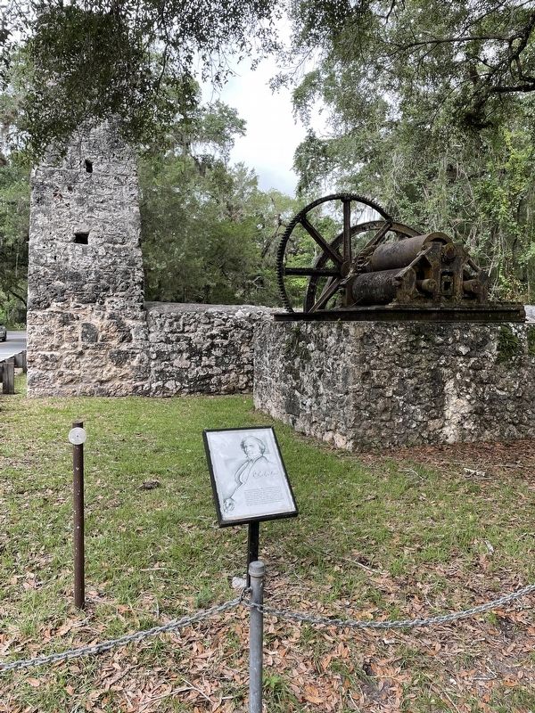
On West Yulee Dr 0.1 miles north of West Bresler Court, on the right when traveling north.
David Levy Yulee (1810-1886), who built Florida’s first cross-state railroad, was the State’s first U.S. Senator. He came to Florida as an immigrant and rose to become an outstanding businessman and statesman. He served in Florida’s territorial . . . — — Map (db m237298) HM
On West Oak Park Boulevard (County Route 480) 0.5 miles east of Florida Route 589, on the right when traveling west.
Turpentine camps were found throughout Florida in the late 1800s and early 1900s. Working in teams of 10 to 20, men scraped strips of bark from the longleaf pines and collected the resin in waiting containers. The resin would then be moved to . . . — — Map (db m267756) HM
On West Yulee Drive 0.1 miles north of West Bresler Court, on the right when traveling south.
The juice flowed from the settling vats into the “grande,” the largest of five kettles built into the furnace below. The “grande” was also the coolest, being farthest from the “batterie” kettle under which the furnace was fired. The chimney draft . . . — — Map (db m237432) HM
On West Yulee Drive, on the right when traveling east.
All Gave Some, Some Gave All Our Heroes Dedicated to all who serve Dedicated to the Men and Women of the United States Armed Forces. Their sacrifices have and continue to preserve the Freedom we Americans have long enjoyed. Thanks is not . . . — — Map (db m238658) WM
Near West Yulee Drive 0.1 miles north of West Bresler Court, on the right when traveling south.
The steam powered machinery which removed the juice from the cane was located here.
The fresh-cut cane was mashed between large, rotating iron cylinders and the juice was collected in vats. The crushed cane, called “bagasse,” was piled and . . . — — Map (db m175844) HM
Near South Marquis Point just north of South Suncoast Boulevard (U.S. 19/98), on the left when traveling south.
Stage Stand was a stopping place of the mail wagon run by the U.S. Army during the 1800’s. It became a cemetery by chance.
The Seminole wars lasted intermittently from 1818 until 1858. During that time American settlers moved in to hunt and . . . — — Map (db m175841) HM
Near West Yulee Drive 0.1 miles north of West Bresler Court, on the right when traveling south.
The steam powered machinery which removed the juice from the cane was located here.
The fresh-cut cane was mashed between large, rotating iron cylinders and the juice was collected in vats. The crushed cane, called “bagasse,” was piled and . . . — — Map (db m175846) HM
On West Aquaduct Street at South Pittsburgh Avenue, on the left when traveling east on West Aquaduct Street.
The wide sidewalks of Homosassa Springs are a reminder of the 1920s Florida Land Boom in Citrus County. In 1924, at the height of the boom, the Florida West Coast Development Company bought several thousand acres in what is now Homosassa Springs and . . . — — Map (db m67594) HM
On North Pine Avenue 0.1 miles north of West Main Street (U.S. 41), on the right when traveling north.
This building, built in 1912, as the George Dickenson Grocery Store owned by Frank & George Dickenson, was constructed of red clay brick laid 12” thick and tied together with 1” iron rods to hold the 2nd story in place, with wood burning . . . — — Map (db m117169) HM
On Courthouse Square north of Old Main Street, on the left when traveling north.
Reportedly, this land was purchased by W.S. Warnock, founder of the Citrus County Chronicle and George Demuro, Clerk of the Court, in 1908. The building was constructed and operated by City Savings Bank in 1910. Edward Sasser ran a dry goods store . . . — — Map (db m122701) HM
Near South Florida Avenue (U.S. 41) 0.5 miles north of East Fort Cooper Road, on the right when traveling north.
More than 1,500 soldiers died and $20 million was spent in the Second Seminole War. It was the most costly of three conflicts between the U.S. and the Seminoles in Florida. Fought from 1835–1842, the war broke out when Seminoles resisted . . . — — Map (db m101818) HM
On West Main Street at North Pine Avenue, on the left when traveling east on West Main Street.
”The Citizen's Bank” built this structure around 1912 and failed in the late 20’s. It was later occupied as: Vann's Drug Store, Bacon's Drug Store, Lanier's Drug Store, Culpepper's Drug Store, Bennett's Drug Store, Marshall's Drug . . . — — Map (db m125473) HM
Near East Turner Camp Road (County Road 581) at Parker Street, on the right when traveling north.
It’s July 26, 1539…
An advance guard of Hernando de Soto’s army has moved through a nearby area and crossed the present-day Withlacoochee River -
It took us two days to cross the river. The rest of our army soon followed. Weighed . . . — — Map (db m126578) HM
On North Apopka Avenue north of Courthouse Square, on the right when traveling north.
The All-American drink was introduced to Citrus County in the early 1900's. W.T. Baxley acted as a sub-bottler to the Tampa Coca Cola Bottling Company, and began bottling it in Hernando in 1906. Empty bottles were washed in Hernando Lake, then . . . — — Map (db m117170) HM
Near Old Floral City Road 0.2 miles south of Carnegie Drive, on the right when traveling south.
Prior to the Spanish arrival in the 1500s, there were hundreds of thousands of Native Americans living in Florida. Evidence of their diverse culture has been discovered in the mounds, earthworks, middens and other archaeological sites found . . . — — Map (db m132271) HM
On South Old Floral City Road 0.2 miles south of Carnegie Drive, on the right when traveling south.
Fort Cooper was constructed in April 1836 during the Second Seminole War. General Winfield Scott instructed the First Georgia Battalion of Volunteers under the leadership of Major Mark Anthony Cooper to build two bastions and a blockhouse on the . . . — — Map (db m93258) HM
Near Old Floral City Road 0.2 miles south of Carnegie Drive, on the right when traveling south.
Setting the Scene In the Spring of 1836, President Andrew Jackson ordered General Winfield Scott, commander of the U.S. Army in Florida, to punish and defeat the belligerent Seminoles. Gen. Scott devised a complicated plan in which three . . . — — Map (db m132055) HM
On Dr. Martin Luther King Jr. Avenue at East Dampier Street, on the right when traveling north on Dr. Martin Luther King Jr. Avenue.
This church was first organized September 29, 1894 by Rev. A.L. Dutch, Deacon Arthur Bell, and the entire membership of Shialo Baptist Church from Stage Pond, Florida. Over the last 116 years, this congregation has been led by 16 different . . . — — Map (db m72781) HM
On W Main Street at S Apopka Avenue, on the left when traveling east on W Main Street.
Citrus County was formed from Hernando County in 1887 and Mannfield, in the center of the new county, was chosen as the temporary county seat by the state legislature. After a political tug-of-war and several elections, Inverness was chosen as the . . . — — Map (db m3529) HM
On West Main Street (Old Main Street) east of North Pine Avenue, on the right when traveling east.
The Masonic Temple for Citrus Lodge #118, F. and A.M., was built on Main Street and dedicated in 1910, ready for occupancy in January, 1911. A splendid three-story brick building costing $17,285, the most costly building in the county. Originally . . . — — Map (db m122748) HM
On West Main Street (Gulf to Lake Highway) (State Road 44) west of North Osceola Avenue, on the right when traveling west.
This two story wood frame Colonial Revival style residence features a beautiful verandah best suited for socializing on warm summer evenings was built in 1903, by James Keels Kelley. According to a 1936 Citrus County Chronicle article, J.K. Kelley . . . — — Map (db m126053) HM
On Courthouse Square at Old Main Street, on the right when traveling north on Courthouse Square.
Korea
Maj Daniel Francis Rooks •
Pvt Arthur P. Carlsen •
PFC Richard G. Sanders
Vietnam
Capt. William Hoover Craig Jr. •
1st Lt. Stanley Gerald Hartson •
Sgt. Carl Henry Joiner •
WO Richard Smith Lowes •
PFC Herbert . . . — — Map (db m77488) WM
Near Old Floral City Road 0.2 miles south of Carnegie Drive, on the right when traveling south.
Adapting to Life in the Cove Necessities of Life Before the Seminole were forced to move to the Cove, they were farmers and ranchers who lived in sturdy log homes and based their wealth on large herds of cattle and extensive crops. Unlike the . . . — — Map (db m132276) HM
Near Old Floral City Road 0.2 miles south of Carnegie Drive, on the right when traveling south.
The Siege of Fort CooperA Hastily Built Defense In March 1836, General Winfield Scott launched a campaign to surround the Seminole in the Cove with an army of approximately 5,000 men. While marching to Fort Brooke in Tampa they stopped . . . — — Map (db m132281) HM
On Tompkins Street at North Osceola Avenue, on the right when traveling east on Tompkins Street.
According to the old family bible, Robert Orval and Emma (Demoss) Hicks, Tennessee farmers, married in 1888 and established a successful steam boat business, carrying fruit and vegetables down the Withlacoochee River just east of Inverness. A freeze . . . — — Map (db m126038) HM
Near East Dampier Street east of North Mill Avenue when traveling east.
It’s July 25, 1539…
Captain Moscoso is leading Hernando de Soto’s army north, from the village of Tocaste, to support De Soto’s scouting party…
Passing near a large lake, we were met by messengers sent by De Soto. They told us the . . . — — Map (db m126577) HM
On West Main Street at North Pine Avenue, on the right when traveling west on West Main Street.
The current Bank of Inverness building was erected on Main Street in 1916 and housed the Citrus County Bank which closed in January 1929. By June of 1929 the only remaining bank in Citrus County was the Bank of Homosassa. On November 20, 1929, the . . . — — Map (db m126084) HM
On Courthouse Square north of Old Main Street, on the left when traveling north.
This building was built by Francis Marion Dampier, Jr. as Dampier Department Store.
The family operated the successful department store from 1945 to 1967. It is remembered that "Frank" Dampier spent many hours sitting on a wooden bench under an . . . — — Map (db m117177) HM
On Old Main Street east of North Pine Avenue, on the left when traveling east.
This building, best remembered as Allen’s 5, 10 & 25 Store, was built by Jack Kibler in the early 1920’s. Occupants included the Inverness Post Office, Vann’s Drug Store and Ernest Johnston’s Restaurant prior to Allen’s 5, 10 & 25 opening in 1932. . . . — — Map (db m125464) HM
On West Main Street (Gulf to Lake Highway) (State Road 44) at South Seminole Avenue, on the right when traveling east on West Main Street (Gulf to Lake Highway).
This house was built in 1903 for George Carter, Citrus County's third sheriff. The Carter House was the first house in Inverness to have a bathroom and was one of the first 13 buildings in Inverness to be “wired up” when electricity came . . . — — Map (db m126060) HM
On West Main Street (Gulf to Lake Highway) (State Road 44) east of South Osceola Avenue, on the right when traveling east.
This building was reportedly constructed in the early 1900's as a library. It was later occupied by School Superintendent R.L. Turner until the 1912 Courthouse was constructed and his office moved there.
In 1917 the Woman's Club of Inverness was . . . — — Map (db m126081) HM
On North Apopka Avenue 0.1 miles north of West Dampier Street, on the right when traveling south.
Built around 1915, this house is most remembered for the McLeod family who lived here from 1941 to 1998. Oscar Penn McLeod was born to a pioneer family near Perry, Florida. He was awarded a teaching certificate in 1918 and married Mayo Artie . . . — — Map (db m117128) HM
Near Old Floral City Road 0.2 miles south of Carnegie Drive, on the right when traveling south.
Seminole Migration Story of Survival The Seminole are descendants of the Muscogee group consisting primarily of Creek Indians from Georgia and Alabama. In the early 1700s, various bands of Creeks and other Muskogean peoples began to migrate . . . — — Map (db m132273) HM
On Courthouse Square 0.1 miles north of West Main Street (U.S. 41), on the right when traveling north.
Mrs. Pearl G. Maddox built the theatre in 1926-27 during the silent movie era, naming it the Valerie after her daughter. The first movie shown was “The Only Woman” in 1927; the last was “The Untouchables” in 1987. Herbert . . . — — Map (db m117178) HM
Near Old Floral City Road 0.2 miles south of Carnegie Drive, on the right when traveling south.
The Second Seminole War BeginsA Year of Victory for the Seminole In the early 1830s pressure to remove Florida's Indians grew intense. Seminole leaders signed treaties in 1832 and 1833 that called for the tribe to relocate within three . . . — — Map (db m132277) HM
On Courthouse Square at Old Main Street, on the right when traveling north on Courthouse Square.
World War I
John T. Allen •
Bryan I. Barnes •
Leroy Black •
Iley Herring •
William F. Nettles •
Willie Rawls •
Fred O. Roux
World War II
Elwood J. Allen •
Wilbur M. Bertine •
James P. Blanton •
Fronie L. Boyd • . . . — — Map (db m77490) WM
On Coast Line Drive just east of Janes Memorial Scenic Drive.
Georgia native, adopted son of Florida, U.S. Army Air Corps veteran, U. of Miami graduate, attorney, founder of the Florida Nature Conservancy, member of Tropical Audubon, South Florida Orchid Society and self-trained field biologist, he . . . — — Map (db m169197) HM
On Broadway Avenue East at Copeland Avenue South (County Route 29), on the right when traveling north on Broadway Avenue East.
Covering 1.5 million acres across Collier and neighboring counties, Everglades National Park, established in 1934 and dedicated in 1947, preserves the largest subtropical wilderness in the U.S. As the first park created to protect a fragile . . . — — Map (db m306926) HM
On Broadway Avenue East, on the right when traveling west.
Barron G. Collier Founder of Collier County Admired for talents Esteemed for vision Beloved for kindness Whom the nation owes the Tamiami Trail Erected by Board Commissioners Collier County To commemorate opening of the Tamiami . . . — — Map (db m213651) HM
On Broadway Avenue East west of Allen Avenue, in the median.
This pleasant 4-lane avenue was laid out in 1923. An electric streetcar ran from Dupont down Copeland Avenue and then along Broadway to the river.
The median had a goldfish pond and dish were replaces frequently after the raccoons feasted on . . . — — Map (db m213485) HM
On South Copeland Avenue at Broadway Avenue West, on the right when traveling south on South Copeland Avenue.
Bulit in 1923, the first Collier County jell was located on this site, the southwest corner of the Circle. It was a small, wooden structure that housed a few dozen inmates on the first floor and included living accommodations for the sheriff and . . . — — Map (db m267644) HM
Hours: April to November 9:00-4:4:30
November to April 8:00 -4:30
Come upstairs to the National Park visitor center for information, park maps, exhibits, videos and more!
Along
The Tamiami Trail
Things to see and do (From West to . . . — — Map (db m106245) HM
On Copeland Avenue South at Broadway Street East, on the right when traveling north on Copeland Avenue South.
This building was completed by April 1940 on land donated in May 1939 by the estate of Barron Gift Collier, founder of the county which bears his name and its largest landholder. The congregation at that time was Presbyterian, officially . . . — — Map (db m309606) HM
Everglades National Park is known for stunning wildlife viewing and it unique mix of temperature and topical plants and animals. Its diverse habitat are a refuge for many endangered species. Take time to discover this subtle landscape by walking . . . — — Map (db m309604)
On Copeland Avenue at Broadway Avenue East, on the right when traveling north on Copeland Avenue.
Monday, October 24, 2005
In the hours before dawn Hurricane Wilma made landfall just a few miles Northwest of Everglades City at Cape Romano.
Leaving Mexico's Yucatan Peninsula as a Category I storm, she moved into Southwest Florida as a . . . — — Map (db m213650) HM
Near Tamiami Trail East (U.S. 41) west of Bass Lake Road, on the right when traveling west.
The Ochopee area was founded in 1928 as a tomato farming community and included a prosperous town of homes, packing house, and a general store with Post Office (established in 1932).
This building was originally a cattle barn and then became a . . . — — Map (db m184177) HM
On Copeland Avenue North at Broadway Avenue East, on the right when traveling north on Copeland Avenue North.
This building was completed in 1928 to be the first seat of government for Collier County which was founded in 1923 by entrepreneur and landowner Barron Gift Collier. The Town of Everglades was also headquarters for the building of the Tamiami . . . — — Map (db m309607) HM
On Broadway Avenue West at Storter Avenue South, on the right when traveling east on Broadway Avenue West.
The first permanent white settlers arrived in this region in the late 19th century. A community dependent on hunting, fishing, and farming soon emerged. The land upon which Everglades City now stands was acquired in 1921-22 by Barron Collier, a . . . — — Map (db m309605) HM
On Collier Avenue (County Route 29) at East Broadway Avenue, on the right when traveling north on Collier Avenue.
The Atlantic Coast Line Railroad (ACL) ran between Immokalee (40 miles north) and Everglades from 1928 to 1956. It carried passengers as well as freight and was an important link for the tomato farms in the area.
The station, in typical . . . — — Map (db m190702) HM
On Hibiscus Street West north of West Broadway Avenue, on the right when traveling west.
This site was the home of William Smith Allen who settled here in the 1870s. He sold the property to George Storter, Jr., in 1889 and it was expanded to include a Post Office, trading post, and warehouses for the thriving sugar cane syrup trade. . . . — — Map (db m190547) HM
The Tamiami Trail links the two great cities for which it was named -- Tampa and Miami. It bridges the Everglades, tying together south Florida’s Atlantic and Gulf coasts.
Its official opening on April 28, 1926, by Governor John W. Martin . . . — — Map (db m115634) HM
Near Roberts Avenue West 0.1 miles west of North 15th Street (Florida Route 29), on the right when traveling west.
Bunkhouse
This bunkhouse was originally constructed in the 1930s as two separate buildings on another site. They were moved here and connected to each other in 1946 to house the family's hired cowmen. No cooking was done inside the small . . . — — Map (db m282966) HM
On Roberts Avenue West 0.1 miles east of North 15th Street, on the right when traveling west.
Cane Mill
The Roberts, as well as other South Florida pioneer families, pressed and boiled sugar cane to provide syrup for their own use or to trade for other necessities. Cultivated since ancient times, sugarcane was introduced . . . — — Map (db m282894) HM
On Roberts Avenue West at Bravo Lane, on the right when traveling east on Roberts Avenue West.
Cattle Ranching and Immokalee
The open grasslands around Immokalees were an abundant hunting ground for the Caluas Indians and later, for the Seminole and Microsukee peoples. Cattleman Charles W. Hendry is thought to have . . . — — Map (db m284379) HM
Near Roberts Avenue West 0.1 miles east of North 15th Street (Florida Route 29), on the right when traveling west.
Chicken Coop
Keeping chickens for the family's use was, and still is, a common practice on American farms and ranches. An excellent food source, chickens also helped keep insects under control and provided fertilizer for the family garden. . . . — — Map (db m283008) HM
Near Roberts Avenue West 0.1 miles east of North 15th Street (Florida Route 29), on the right when traveling west.
Cook’s House
Cleaning house, cooking for the family and hired hands, canning, smoking meat, carrying water, sewing, washing and mending clothes, gardening, tending to the sick, and minding the children and grandchildren, were just some of . . . — — Map (db m283036) HM
On Roberts Avenue West 0.1 miles east of North 15th Street, on the right when traveling west.
Farm Equipment
Most of the equipment displayed here was tractor drawn and was used to clear land and maintain the orange grove.
1. Bush Hog: Invented in 1950, the Bush Hog is a rotary blade mower used to cut . . . — — Map (db m282857) HM
Near Roberts Avenue West 0.1 miles east of North 15th Street (Florida Route 29), on the right when traveling west.
Fertilizer Spreader
Although primarily a cattle ranching family, the Roberts' also grew oranges as a cash crop. This fertilizer spreader dates from about 1940 and was used to apply chemical fertilizers, minerals or pesticides to . . . — — Map (db m282887) HM
On Roberts Avenue West 0.1 miles east of North 15th Street, on the right when traveling west.
Garage
Southwest Florida's early pioneers traveled on horseback, in canoes, mule wagons, ox cart and on foot. Roads were few and far between and were often nothing more than a deeply-rutted trail in the sand.
Collier . . . — — Map (db m282993) HM
Near Roberts Avenue West 0.1 miles east of North 15th Street (Florida Route 29), on the right when traveling east.
Hide House
This hide house was built around 1950 and replaced an earlier log smokehouse. Here, cowhides were stored before being sent away for tanning.
The hides were salted and stacked together tightly to allow the rock salt to . . . — — Map (db m282963) HM
Near Roberts Avenue West 0.1 miles east of North 15th Street (Florida Route 29), on the right when traveling west.
Cowmen kept their horses in this four-stall barn, along with their riding tack carlier barn that was on the property when the Roberts family arrived.
The cowmen’s horses were descendants of those that were brought to Florida by Spanish . . . — — Map (db m283044) HM
Near Roberts Avenue West 0.1 miles west of North 15th Street (Florida Route 29), on the right when traveling west.
Horse Ramp
Trucking the cowmen and their horses out to the cattle herd saved time and spared the riders many long hours of travel in the saddle. This loading chute or horse ramp was built in the late 1940s and was used to walk horses onto . . . — — Map (db m282968) HM
On Roberts Avenue West 0.1 miles west of North 15th Street, on the right when traveling east.
Horse Stall
This freestanding horse stall was built in the early 1940s. Horses were tied to the stall by lengths of rope that permitted the animals to lie down and get up easily.
A cowman would tether his horse in these . . . — — Map (db m282836) HM
On Roberts Avenue West east of North 15th Street (Florida Route 29), on the right when traveling east.
The Roberts family was one of four families that made up Immokalee's first Baptist congregation. The church was organized as a mission in the fall of 1916 by Reverend A.M. Bennett and Reverend Peelman with seven charter members, including . . . — — Map (db m282824) HM
On Roberts Avenue West 0.1 miles east of North 15th Street, on the right when traveling west.
Kitchen
This kitchen was built soon after the Roberts family arrived in Immokalee in 1914 and is the oldest building on the homestead. It was originally placed on an east-west axis and was connected to the Roberts' log pen home . . . — — Map (db m282862) HM
On Roberts Avenue West 0.1 miles west of North 15th Street, on the right when traveling west.
Log Pen
Many of Immokalee's early white settlers built their first homes from pine or cypress logs that were notched at the ends and stacked to form the walls of a single-room cabin or pen. These logs are all that remain of the . . . — — Map (db m282898) HM
Near Roberts Avenue West 0.1 miles east of North 15th Street (Florida Route 29), on the right when traveling west.
Outhouse
This outhouse or privy is typical of those built by the Works Progress Administration during the 1930s to improve health and living conditions in rural areas of the United States. Between 1933 and 1945, the WPA built 2,309,239 . . . — — Map (db m283034) HM
On Roberts Avenue West 0.1 miles west of North 15th Street, on the right when traveling west.
Pole Barn
This pole barn was built in 1943 to store and protect farm machinery. The roof is original and now shelters equipment that was once used to maintain the Roberts' orange grove. A small grove had already been planted . . . — — Map (db m282843) HM
On Roberts Avenue West at Bravo Lane, on the right when traveling east on Roberts Avenue West.
Roberts Family Home
Robert Roberts (1884-1963) and his wife, Sarah Jane Cordell Roberts (1882-1966) came to Immokalee from Ona, Florida, in 1914 with their seven children. Two more children were later born in Immokalee. . . . — — Map (db m284381) HM
Near Roberts Avenue West 0.1 miles east of North 15th Street (Florida Route 29), on the right when traveling west.
Smokehouse
In the days before electricity and refrigeration, meat was cured with salt and smoked over a fire to keep it from spoiling. The women of the Roberts household were responsible for salting the meat, hanging it to dry, building a . . . — — Map (db m283038) HM
On Roberts Avenue West 1 mile east of North 15th Street, on the right when traveling west.
Sugarcane - Boiler
This brick sugarcane boiler was built in 1921 and strengthened with an old buggy spring. It was repaired in 1944 and has a chimney, firebox, and cast iron cane vat or kettle.
Boiling raw sugarcane juice . . . — — Map (db m282858) HM
Near Roberts Avenue West 0.1 miles east of North 15th Street (Florida Route 29), on the right when traveling west.
Truck & Tractor Shed
Trucks, tractors and other equipment saved the rancher precious time in a chore-filled day. The Roberts built this shed in the 1940s to shelter their tractor and horse truck.
The tractor was used to cultivate and . . . — — Map (db m282977) HM
Near Roberts Avenue West 0.1 miles east of North 15th Street (Local Route 29), on the right when traveling west.
Wash Shed
The family moved their laundry from the old log pen to this site when their new home was completed in 1926. Water to do the washing was pumped by hand from a nearby well.
Clothes had to be boiled to remove the dirt, scrubbed . . . — — Map (db m283040) HM
On Roberts Avenue West 0.1 miles east of North 15th Street, on the right when traveling west.
Water Tower
The main house was originally built without running water or modern indoor plumbing. Later, the Roberts family supplied their home with water that was pumped from a well and stored on top of a water tower. A windmill . . . — — Map (db m283006) HM
On Roberts Avenue West 1 mile west of North 15th Street, on the right when traveling west.
Well
Every permanent homestead on the Florida frontier needed a readily available source of fresh water, such as this well near the Roberts' original home site. Before the days of modern plumbing and running water, drawing . . . — — Map (db m282859) HM
On Goodland Road south of San Marco Road, on the left when traveling south.
Named by first settler, Johnny Roberts, Goodland was built on Calusa shell mound by early settlers.
Clam Shell Access Road was built almost single-handedly by pioneer, Harry Pettit, circa 1940. — — Map (db m277553) HM
Near Indian Hill Street at Scott Drive, on the right when traveling east.
Originally “The Heights” (51 feet) highest elevation in SW Florida;
Site of The Heights Hotel - 1908.
Home of J.M. and Tommy Barfield. Mrs. Barfield was very important in the development of Caxambas, Marco Island and Collier County. . . . — — Map (db m277338) HM
On South Barfield Drive south of Hawaii Circle, on the left when traveling south.
1901-1906
Early agricultural venture; plantation and warehouse on Caxambas Ridge.
Hurricane with salt water surge destroyed crops and soil. — — Map (db m277552) HM
On Blue Hill Creek Drive 1 mile west of Whiskey Creek Drive, on the right when traveling west.
Vacation home and plantation house built by Captain John F. Horr (1843-1906) who, together with his family lived on the island from 1877 to 1920. During that time the island was a thriving community with a pineapple plantation, packing plant and . . . — — Map (db m277312) HM
Near Tamiami Trail East (U.S. 41) south of San Marco Road (County Route 92), on the right when traveling south.
This walking dredge, built by the Bay City (Michigan) Dredge Works, is the earliest known survivor of its type. Designed for use over swampy terrain where wheeled or tracked vehicles would bog down the machine’s weight was distributed over shoes. To . . . — — Map (db m195057) HM
Near Tamiami Trail East (U.S. 41) near San Marco Road (County Route 92), on the right when traveling south.
How the Bay City Walking Dredge No. 489 was saved
Bay City Walking Dredge No. 489 was built in Bay City, Michigan in May, 1924 and was shipped to W.R. Wallace & Co. of Fort Myers, Florida. The dredge was later sold to Alexander, Ramsey . . . — — Map (db m195018) HM
Near Tamiami Trail East (U.S. 41) just south of San Marco Road (County Route 92), on the right when traveling south.
Once, occupied by the Caloosa Indians and the Spanish, it was the last refuge of the Seminoles. The region is drained in a north-south direction by creeks, rivers, sloughs and swamps. Abounding in wildlife, trees, plants, shrubs and flowers, most of . . . — — Map (db m194947) HM
This site possesses exceptional values as an illustration of the nation's natural heritage and contributes to a better understanding of the environment. — — Map (db m268153) HM
On 12th Avenue South at 8th Street South, in the median on 12th Avenue South.
This "Back Bay" area was settled in 1915. As Naples' first sheltered mooring, it became the community center for the pioneers building the Tamiami Trail as well as the fishing industry. The first pharmacy, the first newspaper, and all the important . . . — — Map (db m127760) HM
Born December 28, 1891, in Winchester, England, Ernest George Rogers came to the United States in 1913 at age twenty two. In his early years in the U.S., he became head of the accounting department of Remington Arms Company—the major supplier of . . . — — Map (db m278631) HM
Near Tamiami Trail East (U.S. 41) south of San Marco Road (County Route 92), on the right when traveling south.
In plan view, the dredge machinery is mounted on a rectangular frame with the boom and dipper attached at the center of the "front” edge (Fig. 3). The dredge normally rests on four skid-like shoes, one at each corner of the frame each shoe is . . . — — Map (db m194950) HM
William Dutcher was the first president of the National Association of Audubon Societies, appointed in 1905. He helped shape the organization and worked tirelessly for bird protection. He was instrumental in establishing the Audubon warden program . . . — — Map (db m164918) HM
The Baker-Curry tree is named for two individuals whose unlikely partnership saved Corkscrew and established it as an Audubon Sanctuary. It started with passionate citizens who came together to stop the logging of the last remaining old-growth bald . . . — — Map (db m164919) HM
Aldo Leopold is considered the father of the modern conservation ethic. He lamented the toll wrought on the landscape in the name of material progress, and the ever widening disconnect between society and land. Where John Muir was inspired by . . . — — Map (db m164909) HM
Theodore Roosevelt, the 26th president of the United States (1901-1909) is known as the "conservationist president" for creating the Division of Forestry and protecting 230 million acres of federal land. He was a member of Florida Audubon during . . . — — Map (db m164912) HM
Guy Bradley is one of the heroes of Audubon and one of the most colorful characters of its history. He was the first warden to be deputized by Audubon, a strange fact due to his passion for hunting birds for their valuable, fashionable plumes. When . . . — — Map (db m164913) HM
1272 entries matched your criteria. Entries 101 through 200 are listed above. ⊲ Previous 100 — Next 100 ⊳