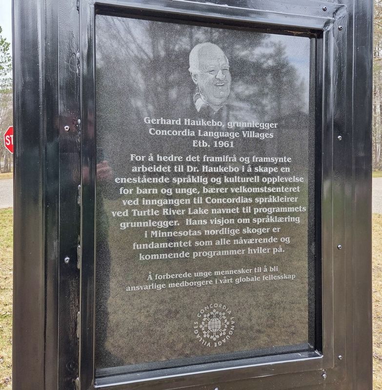
In recognition of the remarkable foresight of Dr. Haukebo in creating an unparalleled language and cultural immersion experience for young people, the Welcome Center of Concordia Language Villages at the entrance to the Turtle River Lake sites . . . — — Map (db m307392) HM
Norway Pine planted in memory of Harry Davidson 1894 — 1983
Harry and Vera Davidson operated Sunset Lodge on this site from 1938–1970. It included a café & bar, 9 cabins, and boat rentals. — — Map (db m199596) HM
Waskish was named by the Chippewa Indians who hunted, fished, and gathered wild rice along the Tamarack River. The Ojibway word for deer is Wawaskishi, which was shortened to Waskish by the early pioneers. The old town site was located at the . . . — — Map (db m181008) HM
Can you imagine the waves on a lake this size?
If you visited this region 10,000 years ago, the sight of Glacial Lake Agassiz would have astounded you! Covering 200,000 square miles, spanning numerous present-day states and . . . — — Map (db m307646) HM
Several years of dry weather set the stage for the devastating fire of 1931
Prelude to Disaster
The bog's early settlers often set fires to burn trash or to clear land for planting. During dry spells, these fires created . . . — — Map (db m308930) HM
As far back as 1927, walleye eggs were harvested at the mouth of the Tamarac River. Eggs collected here were sent to the State Hatchery at Redby for hatching until 1941 when the Waskish Hatchery was built as a Works Progress Administration . . . — — Map (db m272963) HM
River Routes
Our local rivers were used for transportation for centuries, first by Indians, later by white fur traders, explorers, trappers and hunters. From Red Lake, early travelers could canoe either to Lake Winnepeg via the . . . — — Map (db m272830) HM
In 1891, government surveyors platted this area as "meadows." Travel was difficult until drainage ditch spoil piles provided a rough bed for the first road, present-day Highway 72. A road linking Baudette and Kelliher was completed in 1914. . . . — — Map (db m191359) HM
Tradition holds that Red Lake was named after its beautiful red sunsets. The name first appeared on a 1755 map as "Lac Rouge," (French, translation–Red Lake.)
The great glaciers that covered Minnesota melted, first in the . . . — — Map (db m272683) HM
The surface area of Red Lake is 444 square miles. It is the largest lake found entirely within Minnesota borders.
Mille Lacs Lake ranks number two at 207 square miles, less than half the size of Red Lake.
Leech Lake is 175 square . . . — — Map (db m310742) HM
The Big Bog was the last refuge for the lower 48 states' woodland caribou, which vanished in the 1940s. Although caribou survived in Minnesota for a century after they disappeared in Wisconsin and Michigan, multiple threats took their toll here. . . . — — Map (db m190013) HM
An early 20th century attempt to drain the bog failed, but the old ditches still mark the invincible, yet fragile landscape.
Taking on the Bog
In 1889, the federal government appropriated almost three million acres of the Red Lake Indian . . . — — Map (db m191353) HM
Constructed by dragline in the 1960s, this ditch was used by fishermen as a marina and safe harbor. Shallow water, strong winds and big waves made mooring fishing boats difficult. Docking boats by the campground along the Tamarac River could also . . . — — Map (db m191558) HM
The Big Bog is part of the Patterned Peatland of Minnesota, whose rare landforms and plant and animal communities provide a vital resource for for scientific research, education, and recreation. A place of wonder and renewal for many, the Big Bog . . . — — Map (db m191556) HM
The Red Lakes have a long history of walleye production that supported a successful commercial fishery, a constant subsistence fishery, a popular sport fishery, as well as provided a source of walleye eggs for introducing or enhancing walleye . . . — — Map (db m272744) HM
You are standing at the site of an old forestry station, established decades ago to fight one of the biggest foes of forests—fire!
While pickaxes and pulaskis were common fire-fighting tools, a forester's biggest weapon may have been a tower. . . . — — Map (db m207228) HM
Minnesota Territory 1849-1858On March 3, 1849, during his last hours in office. President James K. Polk signed a bill adding a new name to the American political landscape — Minnesota Territory. A vast land, it stretched from the St. . . . — — Map (db m205213) HM
Placed on the National Register of Historic Places on Oct. 14, 2010. Built in 1896 at a cost of $3,300 on land given by Sevrin & Lisbet Huselid. — — Map (db m130999) HM
About 1866 a trading post on the Fort Wadsworth Trail was established on
Tokua Lakes a mile west of town. Early in 1878 Archbishop Ireland, after erecting a church on the present town site, located several hundred families in the vicinity through . . . — — Map (db m156662) HM
The village of Odessa began in 1879 with it's first settler, A.D. Beardsley. He was the Milwaukee depot agent and owner of the first general store. Mr. Beardsley lost a three-year-old daughter, Dessa, to diphtheria. It was after this girl that the . . . — — Map (db m100967) HM
Imagine a tremendous torrent of glacial melt water pushing and then bursting across the continental divide and scouring its way to the Gulf of Mexico. The massive river was, in places, almost two miles wide and 130 feet deep. About 13,000 years . . . — — Map (db m160960)
Of all the geological agents which have played a part in shaping the face of Minnesota, the most overwhelming and powerful one is glacial ice. At least four times during the last million years, continental glaciers have spread over the state . . . — — Map (db m101379) HM
Legend has it that Paul Bunyan was mighty in the sport of fishing as in all else. He picked Minnesota for most of his fishing and is credited with creating more than a few of its ten thousand lakes.
Big Stone Lake, visible here to the . . . — — Map (db m101378) HM
Red River Ox Carts were made of wood and leather. They could hold over 600 pounds. Trading posts had regular routes — one at Hartford State Park in South Dakota, one at the foot of Big Stone Lake and one about 8 miles up. — — Map (db m306963) HM
The above locations of Welsh Churches were established in Blue Earth County after the first Welsh settlers expanded from this farm site, which was claimed by Humphrey Jones and Thomas Y. Davis on April 26, 1855.
In the wooded area . . . — — Map (db m203325) HM
"Who says we cannot build railroads in the winter?" asked the Mankato Weekly Union on December 10, 1869, in an article announcing that the tracks of the St. Paul & Sioux City Railroad had reached the new town of Lake Crystal.
The . . . — — Map (db m67364) HM
When still a daring young flier barnstorming southern Minnesota in August, 1923, Lindbergh landed in the wheat field just northwest of where this Plaque is located. A devil-may-care youngster, he took up adventurous customers at five dollars a . . . — — Map (db m277562) HM
Philosophy.
Amos Owen was a Dakota elder and spiritual leader who wanted to preserve and restore traditional Dakota beliefs and practices. He believed that the suppression of Indian peoples had led to many parts of the culture being almost . . . — — Map (db m21588) HM
This land was first designated for a courthouse in 1854, just one year after the Territory of Minnesota created Blue Earth County. In 1856, Blue Earth County built the first county building, a log jail and frame single-story house, for the . . . — — Map (db m274057) HM
Frances "Bick" Kenney, daughter of Patrick and Rose Kenney, was born on July 13, 1891, in Minneapolis, Minnesota. The Kenney family lived in this house from 1898 to 1911. Frances Kinny Kirch and Maud Hart Lovelace were lifelong friends. Maud . . . — — Map (db m237496) HM
Maud Palmer Hart, daughter of Thomas and Stella Hart, was born on April 25, 1892, in Mankato, Minnesota. The Hart family lived in this house from 1892 to 1906. It was here that Maud met her best friend, Frances "Bick" Kenny, who moved into the . . . — — Map (db m237515) HM
In Honor of
Union Veterans of
the Civil War
Erected by the City of Mankato
for Alexander Wilkin Post No. 19
Department of Minnesota
Grand Army of the Republic — — Map (db m67086) WM
The last act of the Minnesota Dakota (Sioux) War took place here in Mankato on December 26, 1862 when thirty-eight Dakota Indians died in a mass execution on this site.
The Dakota War was a culmination of years of friction between Dakota . . . — — Map (db m14195) HM
Early European explorers were drawn to the Minnesota River Valley's unique characteristics just like the Native Americans before them. French Fur Trader and Explorer Pierre Charles Le Sueur was the first recorded European explorer of the . . . — — Map (db m237541) HM
European settlers began arriving in the area in the 1850s. The Treaty of Traverse des Sioux, signed July 23, 1851, allowed settlers to claim land that had once belonged to the Dakota. In 1852, Parsons King Johnson and Henry Jackson claimed the . . . — — Map (db m236258) HM
This home, also known as the Eberhart House, at 228 East Pleasant Street (formerly 228 Clark Street) was built in 1903, about the time Adolph Olson Eberhart began his political career. Eberhart, the 17th Governor of Minnesota, was born in . . . — — Map (db m277566) HM
This building was used to store the customer's grain as it was brought in and the finished product of flour or grist until it could be picked up. It may have also doubled as sleeping quarters for those who preferred to wait until their grain could . . . — — Map (db m197027) HM
This area (Bunker Hill) once served as a Civil War recruitment center, but this was not the primary reason for its acquisition. The Mankato City Council purchased approximately 10.2 acres at 150 dollars an acre on October 15, 1874, with the . . . — — Map (db m68276) HM
Through treaty negotiations, the Ho-Chunk or Winnebago moved their homes to Blue Earth County in 1855, and by 1863 they were gone. Parts of what would become Minnesota, Wisconsin and Illinois had been their homeland for centuries. European explorers . . . — — Map (db m14053) HM
Rensselaer Dean Hubbard, successful entrepreneur and civic leader, built his house on Broad Street in three stages: in 1871, 1888 and 1905. During the
late 19th century, many of Mankato’s captains of industry and commerce established their . . . — — Map (db m66338) HM
This house, at 332 Center Street, was the Kenney family home from 1898 until 1911. Patrick Kenney worked for the Singer Sewing Machine Company in Minneapolis and came to work at their Mankato store in 1897. The Kenneys purchased this house in 1898 . . . — — Map (db m202939) HM
The desire to honor the memory of Mankato's Civil War dead prompted a citizens' committee headed by John Ray to purchase the triangular parcel of land in the Warren's Addition, bordered by Broad, Lincoln and Grove streets, and dominated by a . . . — — Map (db m66655) HM
Born in Mankato on April 25, 1892, Maud Palmer Hart lived in this home at 333 Center Street until 1906. In 1897 Frances "Bick" Kenney moved into the house across the street, at 332 Center Street, and the two girls became lifelong best friends. . . . — — Map (db m203292) HM
Following the usual pattern of river town development, steamboating was essential for Mankato, from its founding in 1852 until the arrival of the first railroad in 1868.
During the heyday of steamboating at Mankato, boats based at St. Paul . . . — — Map (db m129536) HM
Since the end of the last ice age, Minneopa Creek has carved a ravine through sandstone bedrock, creating a spectacular double waterfall.
Sometimes roaring, sometimes just a trickle, these falls have been an attraction for hundreds of years. This . . . — — Map (db m231657) HM
Native Americans arrived in the area nearly 11,000 years ago, shortly after the glaciers receded. They lived in small, migratory, family-based groups and used plants and animals from the river valley and nearby uplands. Around 2,500 years ago, . . . — — Map (db m237583) HM
Before the railroads and highways, the river was the best way to get goods and people to the new frontier of southern Minnesota. River transportation was much faster and easier than traveling through the dense forests that covered much of central . . . — — Map (db m236265) HM
Built in 1857 in Mankato Township and was moved to this site, which was once the site of the fur trading post of Henry H. Sibley by the Blue Earth County Historical Society in 1931. — — Map (db m66845) HM
This Park is named in honor of Ray Erlandson, and through him, all the men and women who have served the citizens of the City of Mankato as firefighters promoting and preserving the public's safety. Ray Erlandson served as a City of Mankato . . . — — Map (db m120008) HM
From the founding of Mankato in 1852 to today, this area on the bank of the Minnesota River has served as the birthplace of industrial and commercial development in Mankato. By the turn of the last century, Mankato saw increased industrial expansion . . . — — Map (db m302971) HM
The Seppman wind mill produced flour until it fell victim to natural disasters and new milling technology.
Construction Begins
Realizing the need for a local source of flour, Louis Seppman, a stone mason by trade, began . . . — — Map (db m197018) HM
On October 3, 1887 the City of Mankato purchased 120 acres for $13,088 at the confluence of the Blue Earth and Minnesota Rivers to create Mankato’s first park. Sibley Park was named for Henry Hastings Sibley (later Minnesota’s first Governor) who . . . — — Map (db m66483) HM
On Flag Day in 1926, two German 105mm howitzer field guns were dedicated at this Sibley Park
site as war trophies and memorials to the sacrifice made by those who served from Blue Earth County in
the First World War. These artillery pieces were . . . — — Map (db m66757) HM
This brick home sheltered the renowned novelist Sinclair Lewis in 1919. A native of Minnesota, Lewis worked on the famed book, "Main Street," while residing here. Lewis was the first American to receive the Nobel Prize for Literature in 1930. — — Map (db m66511) HM
This memorial is to honor those Dakota who created the First Mahkato Wacipi in 1972.
The Wacipi is to remember the thirty-eight Dakota executed in Mankato in 1862 and to create a spirit of reconciliation between the people of Mankato and . . . — — Map (db m17506) HM
The
Lorin & Lulu Cray Home
was given to the
Young Women's Christian Association
for the women and girls of
Mankato and vicinity
by
Judge and Mrs. Lorin Cray
1927
This property has been
placed on the
National Register . . . — — Map (db m66783) HM
Archaeology reveals the past in layers of soil here at Minneopa State Park. The artifacts below suggest that people hunted bison for thousands of years. Yet a recent turn of events removed these massive herds from daily life. Bones from slaughtered . . . — — Map (db m197043) HM
Tourtellotte Park is named for Colonel John E. Tourtellotte--a lawyer, Civil War veteran and Mankato philanthropist. Tourtellotte was born July 3, 1833 in Connecticut. He opened a law practice in Mankato in 1857. When the Civil War broke out in . . . — — Map (db m306883) HM
Washington Park
During the summer of 1868, the Minnesota Valley Railway Company contracted more than 500 people to grade and lay ties and tracks from Kasota to Mankato, reaching Mankato October 3, 1868.
The mainline was known as the . . . — — Map (db m66635) HM
The First Presbyterian Church of Mankato traces back to the very early days of the town's settlement. The first church meetings were held in 1855 in a log structure which served as a school and worship space for several congregations. The church . . . — — Map (db m274058) HM
There are various historic markers, monuments and buildings in Mankato and North Mankato dedicated to reconciliation and remembrance of the U.S.-Dakota War of 1862 and the 38 Dakota Warriors executed. Visit each site to learn more about the War . . . — — Map (db m279741) HM
In honor of Amos Owen, Norman Crooks and Hereditary Chief Ernest Wabasha for their lasting efforts toward reconciliation among all people.
Grandfather, I come to you this day In my humble way to offer prayers
for the thirty-eight Dakota who . . . — — Map (db m270048) HM
Robert was park superintendent from 1936 - 1939 at Minneopa State Park. He supervised the Works Progress Act (WPA) projects and planted many trees that still thrive today. Frieda operated a concession stand in the park that is now a visitor center. . . . — — Map (db m226147) HM
As a member of the local advisory board of Minneopa State Park for many years, Mr. Palmer, in October 1927 instigated the planting of the plot of black walnut trees north of the railroad — — Map (db m226153) HM
Cobden is a railway village in Prairieville Township. It was originally named North Branch because of its location near Sleepy Eye Creek, the principal north branch of the Cottonwood River. In 1886 its name was changed to Cobden for the English . . . — — Map (db m69835) HM
When the Second Battle of New Ulm ended on the morning of August 24, 1862, the city lay nearly in ruins. Fearing that it would surely fall if attacked again, Colonel Charles Flandrau ordered the entire city to evacuate. The next day . . . — — Map (db m73792) HM
On April 8, 1885 Chief Engineer Blunt of the Winona & St. Peter Railroad Co. announced that the railroad had decided to build a side track between New Ulm and Sleepy Eye for the purpose of receiving grain. The site was known only as "Siding Number . . . — — Map (db m67411) HM
This tablet was erected by the Junior Pioneers in memory of the following men, women and children of the town of Milford who were massacred by the Indians during the Indian outbreak in 1862.
John Martin Fink. • Monika Fink, his wife. • Max . . . — — Map (db m67952) WM
Erected by the State of Minnesota in 1929 in the memory of the men, women and children of Milford who were massacred by the Indians, Aug. 18, 1862.
John M. Fink • Monika Fink • Max Fink • Carl Merkle • John B. Zettel • Barbara . . . — — Map (db m67951) WM
In the summer of 1862, after years of broken treaty promises and late payments that fueled growing tensions and conflict, some Dakota began an attempt to forcibly reclaim their homeland. After attacking the Redwood (Lower Sioux) Agency . . . — — Map (db m67915) HM WM
In 1850 the Minnesota Territory had a white population of about 6000. In 1858, a year before Minnesota became a state, the population was 150,000.
One of the reasons for this enormous growth was the opening of the “Suland,” land . . . — — Map (db m159781) HM
On May 24, 1887 Nels Hanson platted the small railroad station point in section 8 of Prairieville township as "Hanson Station". A post office had been established in 1886 named Evan by the first postmaster, Martin Norseth, in honor of Hanson's wife . . . — — Map (db m69831) HM
In 1854 Ole and Guri Sorbel immigrated to Rock County Wisconsin from Hallingdal, Norway. In 1856 they settled to your right on the northwest bank of Lake Linden. On September 21, 1876, Bob, Cole and Jim Younger and Charlie Pitts received breakfast . . . — — Map (db m68073) HM
In 1899, the Iowa and Minnesota Land & Townsite Company circulated a petition to locate a railroad station in Lake Hanska Township. The petition was signed by 77 people and on October 9, 1899 the village of Hanska was platted in section 24 by Harry . . . — — Map (db m66468) HM
This memorial is dedicated to the memory of John Armstrong pioneer of Linden Township, in 1857 he represented this part of Brown County as its first Territorial County Supervisor (Commissioner) and later became Linden Township's first . . . — — Map (db m68083) HM
The Sioux Indians called this lake "minne hanska," meaning "long water." The basin of the lake was formed 11,000 to 15,000 years ago by the Wisconsin glacier; the original hard clay bottom is now about 50 feet below the present surface of the . . . — — Map (db m66454) HM
Ole Synsteby was born in Lesja, Gulbrandsdalen, Norway. In the summer of 1873, the Synsteby family migrated to the Lake Hanska area. In 1879 Ole purchased the land which is now designated as Lake Hanska County Park.
The story of . . . — — Map (db m79934) HM
This structure is a replica of many such stabburs found in Norway. There are several variations. "Stabbur" translated means store house.
Benefactors: James & Ferdi Amundson estate.
These Lake Hanska farmers were descendants of Norwegian . . . — — Map (db m68264) HM
This log cabin was built about 1857 by the Omsrud/Thordson and Torgrimson families, immigrants from Valdres, Norway. It originally stood on the Thord Omsrud farm on the shores of Omsrud Lake. The cabin was moved to this site in 1986 by . . . — — Map (db m66437) HM
1917 • 1918
That freedom, law and justice
might be established thruout the Earth
This monument is erected in honor
of the men of Hanska and vicinity who answered
their country's call in the World War.
Oscar O. Haugen • John Thordson . . . — — Map (db m68256) WM
About 5 blocks north of this marker was the location of a very important river crossing for the early settlers of this area, going from the "Shetek Trail" on the south to "Old Leavenworth" and New Ulm on the north side of the Cottonwood . . . — — Map (db m67709) HM
In 1857, settlers platted a townsite in Section 14 of the Leavenworth area. During the next year, Dr. J. B. Calkins established the post office and became its first postmaster. Leavenworth Township was legally organized on April 16, 1859. Seven . . . — — Map (db m68025) HM
The Joseph Brown family with son Jonathan and daughter Oratia were early settlers on a farm five miles west of here along the Shetek Trail. The family fed and over-nighted guests, operating their home as a traveler's inn. Upon hearing news of Dakota . . . — — Map (db m67825) HM
The Church of St. Mary was incorporated on September 26, 1911 by Archbishop John Ireland of St. Paul. The Parish included Catholics living south of Center Street in New Ulm, plus Cottonwood and Courtland Townships. Because of difficult economic . . . — — Map (db m74048) HM
Christian Adam(s) was born circa 1812 in Prussia. He sailed from LeHavre, France aboard the ship Pactolus which arrived in New York City October 12, 1846. The passenger manifest listed his occupation as farmer.
Petronella Keller Adam(s) was . . . — — Map (db m73759) HM
The town gained a new venue for public events in 1873 with the opening of Arbeiter Hall. The local Arbeiterverein, or Workers' Association, organized in 1871, primarily as a workers' insurance association. The two-story brick building had a . . . — — Map (db m67093) HM
Following the outbreak of hostilities between the Dakota and white settlers on August 18, 1862, hundreds of people fled from nearby farms to New Ulm for safety. Quickly, Brown County Sherriff Charles Roos and Jacob Nix, a citizen with German . . . — — Map (db m73140) HM
Brown County, an historic gateway on the Minnesota River, opened the fertile prairie lands of the Great Plains to the northern hardwoods of a continental divide. The U.S. Territorial Legislature organized the county in 1856 from lands ceded by . . . — — Map (db m66749) HM
The Brown County Bank is among the oldest commercial properties within the district. As the local economy recovered from the devastating effects of the Dakota Conflict, the city found itself without a bank following the demise of the First . . . — — Map (db m66879) HM
Dedicated to All Brown County Veterans
This memorial is a lasting tribute to past, present and future veterans who served during peacetime and the following conflicts: Indian Wars 1817 - 1898 ·
Mexican War 1846 - 1848 ·
American Civil War . . . — — Map (db m65526) WM
This three-story building is a fine example of Queen Anne commercial architecture. The original southern section was erected in 1892 for the Buenger Furniture Store, while the corner building was constructed in 1902.
Louis Buenger Sr. . . . — — Map (db m68117) HM
The colorful frontiersman credited with giving Minnesota the nickname of the Gopher State was born in 1828 in New York City of French Huguenot and Irish ancestry. As a young lawyer he moved to Minnesota in 1853. After exploring the Minnesota . . . — — Map (db m206944) HM
Rosa Schnobrich opened the City Meat Market in 1907 with the advertising slogan, "Better Meats, Cleaner Meats, and Quicker Service." Her sausages, in particular, proved popular, and soon her shop began supplying a network of wholesale dealers . . . — — Map (db m68267) HM
2884 entries matched your criteria. Entries 101 through 200 are listed above. ⊲ Previous 100 — Next 100 ⊳