106 entries match your criteria. The first 100 are listed. The final 6 ⊳
Missouri, The State Historical Society of Historical Markers
Markers of the State Historical Society of Missouri installed in every county by the State Historical Society and State Highway Commission from 1951 to 1961. Also includes markers installed in 1958 along the route of the Butterfield Overland Mail in Missouri.
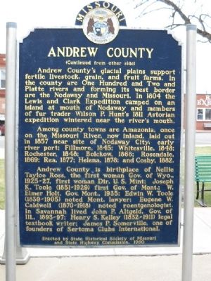
Andrew County, organized 1841, is one of 6 counties in the Indian Platte Purchase Territory annexed to Missouri, 1837. Named for Andrew Jackson Davis, St. Louis editor, the county was first settled in the middle 1830’s. Pioneers were from Ohio, . . . — — Map (db m39756) HM
Side A:
Here on Rock Creek in Missouri's fertile Glacial Plains, Rock Port was laid out, 1851, by Nathan Meek and succeeded Linden as seat of Atchison County, 1856. A leader in corn production, the county, organized 1845, is named for U.S. . . . — — Map (db m48107) HM
[Side A]
Internationally known for its firebrick industry and famed for its saddle horses, this county seat was laid out by Robert C. Mansfield and James H. Smith not long before Audrain County was organized, 1836. Named for legislator . . . — — Map (db m70508) HM
Cassville, the last town
on the route of
the Butterfield Mail in Missouri,
was not a relay station
but the coaches stopped
for mail and passengers — — Map (db m80212) HM
Side A
Lamar is distinguished as the birthplace of Harry S. Truman, the 33rd President of the United States. The son of John Anderson Truman and Martha Ellen (Young) Truman, he was born May 8, 1884. The family moved to Harrisonville in Cass . . . — — Map (db m42286) HM
[Front]
Historic Harmony Mission, a school for the Indians of Missouri, once stood east of Rich Hill, on the north bank of the Osage River, near the centuries-old camping sites of the Great and Little Osage tribes.
The mission was founded . . . — — Map (db m121349) HM
Warsaw, in Benton County, 55 miles from the Tipton Terminus, was a relay and meal station. Accommodations were provided by the Lemon, later Campbell House, and Nichols Tavern. Its building still stands. — — Map (db m140840) HM
[side 1] Here on a scenic hill at the junction of crystal clear Crooked and Hurricane Creeks, Thomas Hamilton laid out Marble Hill after Bollinger County was organized, March, 1851. First called New California, the town was . . . — — Map (db m179953) HM
Columbia, "Educational Center of Missouri", originated in the town of Smithton, laid out by the Smithton land Company, 1819. By 1821, when the name was changed, the town was the seat of Boone Co., organized 1820, and named for Daniel Boone who died . . . — — Map (db m106358) HM
Renowned city of the Pony Express, St. Joseph was first settled as a trading post for the American Fur Company by Joseph Robidoux, 1826. Later he acquired the site and laid out a town in 1843. St. Joseph became an outfitting point for settlers in . . . — — Map (db m4989) HM
(Front): In the Ozark perimeter, above Missouri's Southeast Lowland Region, Poplar Bluff was laid out in 1849 as seat of newly organized Butler County. The town was named for its location in a forest of yellow poplars on the bluffs above . . . — — Map (db m36128) HM
The fertile Shoal Creek Valley, Kingston was laid out in 1843 to replace Far West as seat of Caldwell County. Organized in 1836, the county was to be for Latter Day Saints (Mormons), ejected from Jackson County in 1833 and asked to leave Clay . . . — — Map (db m144715) HM
This is a two sided markerSide A:
Fulton was founded here in the Little Dixie Region of Missouri, 1825, to replace the poorly located Elizabeth as seat of Callaway County. Named for a grandson of Daniel Boone and War of 1812 . . . — — Map (db m78757) HM
The historic Osage River, impounded here by Bagnell Dam, flows east and north some 82 miles to join the Missouri. At the river's mouth, the 1804 Lewis and Clark Expedition camped several days and in 1806 Zebulon M. Pike's Southwest Expedition . . . — — Map (db m78759) HM
[side 1] Founded as an Indian trading post, 1793, by French Canadian Louis Lorimier. Probably named for Girardot, a trader at Cape Rock. In 1795 Lorimier became commandant of Cape Girardeau District, most American of the 5 . . . — — Map (db m179995) HM
(side 1) Fort Orleans, first European post in the Missouri Valley, was built by the French explorer Etienne Véniard De Bourgmond on the Missouri River close by, a few miles above the mouth of the Grand, 1723-24. The exact location of the . . . — — Map (db m132000) HM
(Front): Van Buren, settled as the seat of Ripley County, organized, 1833, became the seat of Carter County when it was organized from parts of Ripley and Shannon counties, 1859. Nearby Big Spring State Park, 4582 acres of Ozark grandeur, . . . — — Map (db m36143) HM
Midway on Missouri's western border, Cass County was organized in 1835 and named Van Buren. The Free-Soil Party affiliation of Martin Van Buren led to name change, in 1849 for Democrat Lewis Cass. In territory ceded by Osage tribes 1825, the county . . . — — Map (db m20267) HM
(side 1)
Here where the Ozark Highland borders on the Western Prairie region of Missouri, Cedar County was organized in 1845. The name is for the trees along Cedar Creek. Stockton, the county seat, was platted in 1846 on land given by . . . — — Map (db m72914) HM
(side 1) Founded, 1832, by Englishman James Keyte, Keytesville is the judicial seat of Chariton County. First seat of the county, organized in 1820, was "Old" Chariton laid out, 1817, near the mouth of the Chariton River by Duff Green, . . . — — Map (db m131898) HM
The John C. Ashmore Relay Station in northwest Christian County stood in Polk Township, 152 ½ miles from the Tipton Terminus. It was the only station in the county. — — Map (db m99690) HM
Deep in the Missouri Ozarks, Christian County, organized 1859, was one of last 3 of the State’s 114 counties to be formed. At the request of pioneer “Mrs. Thomas Neaves” it was named for her native Ky. county honoring Rev. War Col. . . . — — Map (db m99716) HM
(side 1)
Missouri's first northern border county, organized in 1836, is named for explorer William Clark. In 1839, Iowa Territory and the State of Missouri mobilized troops on the nearby border in a boundary dispute called the Honey War for . . . — — Map (db m144553) HM
Early border town, prominent trading and outfitting center, and one of the farthest northwest of U. S. towns to be based on southern culture and economy. Settled about 1820, mainly by southern pioneers, the town became the seat of justice for . . . — — Map (db m81749) HM
Once forming part of Missouri's western boundary, Clinton County was organized in 1833 and named for N.Y. Governor DeWitt Clinton. It lost its boundary status in 1837 when the Indian Platte Purchase territory extended the State border to the . . . — — Map (db m198965) HM
Front
The capital of Missouri, officially named the City of Jefferson in honor of the third U.S. President, is built on a site chosen by the First General Assembly, 1821, for a seat of government. St. Charles, until 1826, was the temporary . . . — — Map (db m62394) HM
Historic Boonville's first settlers were pioneer Mother Hannah Allison Cole and her 9 children who located on the Missouri River bluffs where St. Joseph Hospital now stands, 1810. Hannah, whose husband William T. Cole was killed by Indians, ran . . . — — Map (db m46067) HM
Side A:
Early noted for its rich banks of iron ore, Crawford County was organized 1829, and named for Georgia Sen. W.H. Crawford. In territory ceded by Osage tribes 1808, the county was roamed by the Delaware and Shawnee into the period of . . . — — Map (db m55636) HM
[Side A]
Encompassing 504 sq. miles of the west slope of Missouri's Ozarks, Dade County was organized in 1841 and named for Maj. Francis L. Dade killed in Florida War with Seminoles in 1835. In territory ceded by Osage tribes in 1808, the . . . — — Map (db m79788) HM
[Front]
Dallas County, organized 1841, was first called Niangua for the river flowing within its borders, but the name proved difficult and it was changed to Dallas in 1844 for U.S. Vice Pres. George M. Dallas. Settled in the early 1830's . . . — — Map (db m62544) HM
[Front]
This Grand River town, platted in 1837 as the seat of Daviess County, is named in honor of Albert Gallatin, Secretary of the Treasury, 1801-1813. Settlers were in the area as early as 1830 and in 1836 the county was formed. . . . — — Map (db m67339) HM
[Side A]
DeKalb County, 270,720 acres of rolling prairie land, is one of 19 Missouri counties organized in February, 1845. The name is for German-born Johann Kalb, member of the French army and general in the American Revolution, known as . . . — — Map (db m88146) HM
Salem, an Ozark plateau town, 1,180 feet above sea level, was laid out, 1851, as the seat of newly organized Dent County. The town was named by early settler David R. Henderson for Salem, North Carolina, and the county name honors local pioneer and . . . — — Map (db m99638) HM
Here in the heartland of the Missouri Ozarks, Douglas County was organized in 1857 and named for statesman Stephen A. Douglas. Southern pioneers, attracted by forested hills, abundant game, spring-fed streams, fertile valleys, were first settlers in . . . — — Map (db m189740) HM
Here in the Southeast Lowland Region of Missouri on a Delaware and Shawnee Indian village site, Kennett was laid out as the seat of Dunklin County, 1846. The town was first called Chilletecaux for a Delaware Indian living here at the time. Later . . . — — Map (db m17477) HM
Characterized by old world charm of its German heritage, Washington was founded by William G. Owens who bought acreage here 1828, at the Missouri River ferry then called Washington Landing, Lucinda Young Owens, his widow, filed the town plat, . . . — — Map (db m61607) HM
Often called "Little Germany," Hermann was founded by the German Settlement Society of Philadelphia, 1836, as a colony where German customs and language could be preserved amid the benefits of America. Named for the national Germanic hero, the . . . — — Map (db m43695) HM
[Front]
Gentry County, first formed in 1841, and fully organized in 1845, is named for Mo. Militia Maj. Gen. Richard Gentry, Colonel of Volunteers in the Florida War, hero of the Battle of Lake Okeechobee, 1837, in which he was killed. A . . . — — Map (db m66516) HM
(Front): Queen City of the Ozarks, settled in 1830 by Tennessee pioneers on what had been a Kickapoo, Osage, and Delaware Indian camping ground. Springfield was first called Campbell and Fulbright Springs after its first settlers. Rivalry . . . — — Map (db m35247) HM
[side 1] Trenton, Settled in 1834, became the seat of Grundy County in 1841, when James S. Lomax gave 80 acres for a townsite. The county is named for Felix Grundy, United States Attorney General 1838-1839. The town name is . . . — — Map (db m179714) HM
[Front]
Here in the undulating glacial plains of north central Missouri, Harrison is one of 9 counties forming the State's border with Iowa. Twenty-sixth in size of Missouri's 114 counties, and second largest on the border, it was . . . — — Map (db m66588) HM
[Side A]
Henry County, in the prairie region of west central Missouri, was organized 1834, and named for Va. statesman William C. Rives. It was renamed for Patrick Henry in 1841, after Rives changed from Democrat to Whig. Through the . . . — — Map (db m69513) HM
This is a two sided markerSide A:
Here in the Ozark Highland of Missouri, Hickory County was organized 1845, and named for U.S. President Andrew Jackson, known as "Old Hickory." Lying in the Osage land cession of 1808, the county . . . — — Map (db m78761) HM
[side 1] One of 6 counties formed in the Indian Platte Purchase Territory, annexed to the State 1837, Holt County was organized in 1841 and named for State legislator David Rice Holt. The county's 456 square miles, bounded . . . — — Map (db m179434) HM
[side 1] Judicial seat of Howell County and one of Missouri's livestock marketing centers, West Plains was formed in 1850 when a post office was opened in the home of Josephus Howell. Named for its location on the open plains . . . — — Map (db m179790) HM
(Front): Surrounded by the rugged splendor of the highest peaks of the Missouri Ozarks, Arcadia Valley lies in the geologic center of the Ozarks, one of the world's oldest mountain regions. The valley towns are in an area settled in the iron . . . — — Map (db m38440) HM
Four miles north are restored buildings of Fort Osage, westernmost frontier outpost of the U.S. government until 1819. One of 28 fortified Indian trading posts or "factories" operation on our Indian frontiers, 1795-1822, to promote and protect . . . — — Map (db m90355) HM
Side A:
Independence, famed "City of the Trails," was for two decades the starting point of the great western trade and travel routes to Santa Fe, Oregon, and California. Settled mainly by Southerners on land ceded the U.S. by the Osage . . . — — Map (db m44323) HM
At the confluence of the Missouri and Kansas (Kaw) rivers, on the great bend of the Missouri, longest of the U.S. rivers, this famous city of the vast Missouri Valley was first incorporated, 1850, as the Town of Kansas. The first white man known to . . . — — Map (db m198773) HM
The beautiful city of Carthage was laid out, 1842, as the seat of Jasper County, organized, 1841, and named for Sgt. William Jasper, Revolutionary hero. Centered in a county of great mineral wealth and good farm land, Carthage grew into a . . . — — Map (db m24311) HM
Joplin, at the edge of the Ozark Highland, the city that lead and zinc built, was first sparsely settled as a farming community, 1838, John C. Cox, followed by the Rev. H.G. Joplin, and others. The first post office, 1840, was named Blytheville in . . . — — Map (db m21868) HM
Historic Jefferson County, organized in 1818, the eighth to be formed in Missouri, lies in the southeast Lead Belt, region of the state's oldest settlements. Probably the first American settlement in Missouri was made in this county near the mouth . . . — — Map (db m143477) HM
[Front]
One of Missouri's early western prairie towns, Warrensburg was founded in 1836 as seat of Johnson County, organized in 1834. The town is named for Martin Warren, a pioneer settler, and the county for United States Vice President . . . — — Map (db m85327) HM
Edina, the seat of Knox County, was laid out here in the glacial plains of northeast Missouri, 1839, by W.J. Smallwood. Scotsman S.W.B. Carnegy, who surveyed the new town, named it the poetic form of Edinburgh. The county, formed 1843 and organized . . . — — Map (db m144472) HM
Lebanon, lying 1,265 feet above sea level, in Missouri's Central Ozarks, was founded in 1849 as the seat of newly organized Laclede County. Southern settlers named the town for Lebanon, Tenn. The county name honors the founder of St. Louis. When . . . — — Map (db m44872) HM
The John I. Smith Relay Station was 172 ½ miles from the Tipton Terminus and stood in northeast Barry County, about 7 miles west of Crane. — — Map (db m99688) HM
Marker Front
Wooded Ozark hills and fertile prairies for this county of contrasts organized in 1845 and named for Captain James Lawrence of “Don’t give up the ship” fame. The first settlers, John Williams, located on Turnback . . . — — Map (db m62833) HM
Side A:
Here on the Mississippi, where wooded hills rise above the plains along the river, Edward White, Robert Sinclair, and Isaac Bland founded Canton, probably named for Canton, Ohio, in February of 1830. On the pioneer Salt River . . . — — Map (db m55407) HM
Troy, laid out on the site of Woods' Fort in 1819, lies on an old Sac and Fox Indian campsite where first settlers Joseph Cottle and Zadock Woods built their cabins, 1801. It was the Sac and Fox tribes, outraged by their 1804 land cession which . . . — — Map (db m138510) HM
[Front]
Laclede is distinguished as the boyhood home of John Joseph Pershing, Commander of the American Expeditionary Force in Europe during World War I. He was born near Laclede in Linn County, Sept. 13, 1860. At the time, his parents, . . . — — Map (db m67004) HM
Side A:
On rolling land above the Grand, and between Thompson River and Medicine Creek, Chillicothe was laid out in 1837 as seat of newly organized Livingston County. The name is for Edward Livingston, U. S. Secy. of State, and the town . . . — — Map (db m55364) HM
(side 1) Macon is the seat of justice for one of Missouri's richest coal bearing counties. The town was laid out on rolling upland prairie, between the Middle Fork of the Salt and the East Fork of the Chariton rivers, 1856. Hudson, named for . . . — — Map (db m156228) HM
Here in the southern extent of Missouri’s historic southeast Lead Belt, Fredericktown was laid out on Saline Creek, 1819, by state legislator Nathaniel Cook. Commissioners T. F. Tong, Joseph Bennett, James Dotson, John Burditt, and Henry Whitener . . . — — Map (db m61715) HM
Maries County, in the central Ozarks of Missouri, was organized in 1855 and named for the Big and Little Maries rivers. The area, in territory ceded by Osage Indians 1808, was roamed by French trappers who early named the Gasconade, Bourbeuse, and . . . — — Map (db m171911) HM
Side A:
Palmyra, founded in 1819, was for many years the northernmost town on the Salt River Trail from St. Charles to the Des Moines River. A Federal Land Office for the Salt River area located here, 1824 – 58, led all others in the . . . — — Map (db m55391) HM
McDonald County, 540 sq. miles of Ozark grandeur in Missouri’s extreme southwest, was called Seneca when it was formed in 1847. Fully organized in 1849, it was named for Rev. War soldier Alexander McDonald.
Pineville, the county seat, was . . . — — Map (db m99715) HM
[side 1] Here in Missouri's north central glacial plains, Mercer County was organized, 1845. Named for Rev. War Gen. Hugh Mercer, the county is in territory ceded by Iowa, Sac, and Fox tribes in 1824. Indians hunted in the . . . — — Map (db m179701) HM
[side 1] Here in Missouri's central Ozarks, Miller County was organized 1837, and named for Mo. Gov. John Miller. In territory ceded by Osage (French pronunciation for Wazhazhe Indians) 1808, the county was first settled 1807, . . . — — Map (db m179728) HM
(Front): Comprising 411 square miles of Missouri's great alluvial plain, this county, organized in 1845, is a high producer of cotton, grain, and soybeans. The Mississippi (Algonquin Indian for Great Water), flowing along some 70 miles of the . . . — — Map (db m17721) HM
[Front]
Historic town in the annals of western transportation, Tipton, in 1858-59, was the eastern stagecoach terminus of the famous Butterfield Overland Mail. N.Y. expressman John Butterfield (1801-69), under contract to carry mail and . . . — — Map (db m62481) HM
Mark Twain (Samuel Longhorne Clemens) was born in the nearby village of Florida, Nov. 30, 1835. His birthplace was given to the Mark Twain Memorial Park Association by M.A. Violette, 1924, and is maintained as a museum. The two-room clapboard . . . — — Map (db m161083) HM
The George Shackelford Relay and Meal Station stood ½ miles south of Syracuse in Morgan County. In 1859, when the railroad reached Syracuse, it succeeded Tipton as Stage terminus. Civil War activity closed the terminus in March, 1861. — — Map (db m61425) HM
Morgan County, in Missouri's Lake of the Ozarks Region, was organized in 1833 and named for Revolutionary War Gen. Daniel Morgan. The lake, impounded by Bagnell Dam built on the Osage River in adjacent Miller County 1929-1931, extends into Morgan . . . — — Map (db m140835) HM
(Front) First American town in Missouri. Founded in 1789 by George Morgan, Princeton graduate and Indian trader, on the site of Francois and Joseph Le Sieur's trading settlement, L'Anse a laGraise (Fr. Cove of Fat). Flood and caving banks . . . — — Map (db m238835) HM
[Front]
On rolling prairie above the scenic One Hundred and Two River. Maryville was laid out, 1845, as the seat of newly organized Nodaway County. The town is named for its first white woman settler, Mary House Graham, the wife of county . . . — — Map (db m66480) HM
[side 1] Here in the extreme southern Missouri Ozarks, Oregon County was organized in 1845, and named for the Oregon Territory of the Far West. One of 11 counties along the Arkansas border, Oregon is in a region long roamed . . . — — Map (db m179894) HM
[side 1] Named for the river on its west border, Osage County was organized, 1841. A seat of justice was centrally located the next year and named Linnville, later Linn, for Lewis F. Linn, Missouri's "Model Senator." J.W. Robinson gave land . . . — — Map (db m180900) HM
County of magnificent scenery, in which extend both Bull Shoals and Norfolk lakes, Ozark was organized, 1841. Briefly called Decatur, 1843-45, it is the only county in the United States named for the nation’s oldest mountainous region. The name . . . — — Map (db m140934) HM
(Front): The capital of historic Pemiscot County and center for a cotton, grain, timber, and industrial area, Caruthersville was laid out, 1857, by George W. Bushey and J. Hardeman Walker (1794-1860), on the Walker plantation. "Bootheel" . . . — — Map (db m36219) HM
Some 700 Saxon Lutherans settled, 1839, in Perry County and formed the parishes of Altenburg, Wittenberg, Dresden, Seelitz, Frohna, and one settlement, Johannisburg, in Cape Girardeau County. The community of Paltzdorf (Uniontown) was organized, . . . — — Map (db m35290) HM
Side A:
This Ozark plateau town, 1120 feet above sea level, was a "Child of the railroad." On a natural passageway to southwest Missouri, midway between St. Louis and Springfield, this site was chosen by the Southwestern Branch of the . . . — — Map (db m55637) HM
This is a two sided markerSide A:
Bowling Green, the capital of Pike County, lies 12 miles in from the Mississippi River on a rolling plain, 880 feet above sea level. First pioneer here, John W. Basye, came in 1820 and by 1823, . . . — — Map (db m78676) HM
This is a two sided markerSide A:
Louisiana, early Mississippi River port, known for the Delicious apple developed here and grown through the world, was settled, in 1817, when John Bryson pre-empted land near the confluence of the . . . — — Map (db m78675) HM
[Front]
Platte is one of 6 counties formed from the U.S. Government's 1836 Platte Purchase in which Iowa, Sac, Fox, and small bands of other Indian tribes gave up over 2 million acres of land for $7,500 and other benefits. The Purchase was . . . — — Map (db m66465) HM
Here in Missouri's central Ozarks, Pulaski County was organized 1833, and named for Revolutionary War general, Polish Count Casimir Pulaski. Once roamed by Indians and French trappers, the county is part of land ceded by the Osage . . . — — Map (db m55638) HM
[side 1] Judicial seat of Putnam County since 1853, Unionville lies 1070 feet above sea level in a scenic region of wooded hills and rolling prairies. Unionville, first named Harmony, was the fifth site to be designated county . . . — — Map (db m179724) HM
(side 1) New London, renowned for its handsome courthouse, was founded, 1819, on the route of the historic Salt River Road by William Jamison. By 1820, it became the seat of a newly organized county named for Daniel M. Ralls, local . . . — — Map (db m131897) HM
Moberly, the “Magic City,” grew from the town platted by the North Missouri R.R. (Wabash) in 1866 to a transportation center with a 6,070 population by 1880. The North Mo. acquired the site when it took over the Chariton and Randolph R.R. after . . . — — Map (db m110128) HM
[Side A]
Richmond was founded, 1827, as the seat of Ray County on land donated by John Wollard, W.B. Martin, and Isaac and William Thornton. The county, organized 1820, had its first seat at Bluffton, where Camden, an early Missouri . . . — — Map (db m157138) HM
[side 1] In an area of rugged beauty near the geologic center of the Ozark Highland, Reynolds County was organized 1845, and named for Missouri's 7th governor, Thomas Reynolds. Drained by the Black River, called L'eau Noire by . . . — — Map (db m179937) HM
[side 1] On the hills above lovely Current River, Doniphan was founded, 1847, and became the seat of Ripley County in 1860. George Lee gave 50 acres for the town and named it for Mexican War Col. Alexander W. Doniphan. The . . . — — Map (db m179903) HM
Side 1 Capital of one of the foremost livestock farming counties in Missouri, Lancaster was laid out as the county seat of the newly organized Schuyler County, 1845. Named for Rev. War Gen. Phillip J. Schuyler, the county was a part of the . . . — — Map (db m95689) HM
The second county formed in Missouri's famed Southeast Lowland Region, Scott was organized 1821, and named for John Scott, the State's first Congressman. Southerners were first settlers on Spanish land grants in the late 1790's. The King's Highway . . . — — Map (db m161191) HM
(Front): Here in one of the most beautiful areas of Missouri's Ozarks, Eminence was founded as the seat of Shannon County after it was organized, 1841. First located north of Current River, the town was burned in the Civil War by guerrilla . . . — — Map (db m35926) HM
Bethel, in North River Valley, five miles from Shelbyville, was founded in 1844 as a religious communal colony by Wilhelm Keil and his German-American followers. Keil (1812-1877), an independent preacher, called his adherents "Christians." . . . — — Map (db m149765) HM
First permanent settlement on the Missouri River, known as Les Petites Cotes (Fr. Little Hills) until after dedication of Church of St. Charles Borromeo, 1791. Though 1780 is given as date of founding French-Canadian Louis Blanchette first settled . . . — — Map (db m138183) HM
(Front): Early thriving Osage River post. Osceola was settled during the mid-1830's largely by Southerners. The settlement and its first store were known as the "crossing of the Osage at Crow and Crutchfield's," until the name of the Indian . . . — — Map (db m36090) HM
The county was first visited by white colonists when missionary priests, Illinois French, and Kaskaskia and Tamaroa Indians settled the temporary village of Des Peres, 1700-03. The village site, laid out 18 years after La Salle claimed the . . . — — Map (db m213198) HM
First city of the Trans-Mississippi West and second permanent settlement in Missouri. Founded, 1764, by the New Orleans Frenchman Laclede as a trading post to tap the rich fur resources of the Missouri Valley. Named for canonized Louis IX, French . . . — — Map (db m140858) HM
Oldest permanent settlement in Missouri founded ca. 1735 by Illinois French as river depot for lead and salt. Moved 3 miles to present site after 1785 flood. Named for the patroness sait of Paris.
A vivid reminder of claims of France and Spain . . . — — Map (db m143474) HM
106 entries matched your criteria. The first 100 are listed above. The final 6 ⊳