By Thomas Onions, December 4, 2010
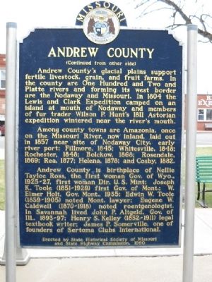
Andrew County Marker
GEOGRAPHIC SORT Title Sort Marker Number Sort Marker Number Sort N Marker Number Sort T Publication Order Sort Publication Order Sort A Erected Year Sort Most Viewed Sort Most Recent-Interest Sort Most Recently Changed Sort SEE FAQ #33 FOR DESCRIPTIONS
On U.S. 136 at Market Street, on the left when traveling west on U.S. 136.
On Mudrow Street (Missouri Route 15) at Hisey Street, on the right when traveling south on Mudrow Street.
On Main Street (State Road Y) at 7th Street, on the left when traveling north on Main Street.
On Gulf Street at 11th Street West, on the right when traveling north on Gulf Street.
On Walnut Street (State Highway A) at 13th Street, on the right when traveling east on Walnut Street.
On Van Buren Street at Main Street, on the right when traveling north on Van Buren Street.
On High Street at Gilmore Street, on the right when traveling north on High Street.
On Old U.S. 63 just south of Shepard Boulevard, on the right when traveling south.
On Penn Street, on the left when traveling east.
On Main Street at Vine Street on Main Street.
On East Main Street just east of North Washington Street (Missouri Highway 13).
On South Market Street south of St. Louis Avenue, on the right when traveling south.
On Bagnell Dam Boulevard, on the left when traveling west.
On North Kingshighway Street (U.S. 61) at South County Park Road, on the right when traveling south on North Kingshighway Street.
Paid Advertisement
On Jefferson Street at 7th Street, on the right when traveling west on Jefferson Street.
On Main Street (Business U.S. 60) at Oliver Street, on the right when traveling north on Main Street.
On East Wall Street, on the left when traveling east.
On South Street (Missouri Route 39) south of Wells Street, on the right when traveling south.
On West Jackson Street (U.S. 24) east of South Cherry Street, on the right when traveling east.
On Highway ZZ, 0.1 miles north of Honeysuckle Road, on the left when traveling north.
Near N. 3rd Street north of W. McCracken Road.
On North Johnson Street (Missouri Route 81) north of East Court Street, on the right when traveling north.
On Water Street north of Kansas Street, on the left when traveling north.
On North Main Street south of East Maple Street, on the right when traveling north.
On Missouri Boulevard (Business U.S. 50) west of Stadium Boulevard, on the right when traveling west.
On Missouri Route 87, on the right when traveling south.
On Missouri Route H, on the right when traveling south.
On Grand Avenue (U.S. 160) at State Route 39, on the left when traveling north on Grand Avenue.
On Cedar Drive at Main Street, on the right when traveling south on Cedar Drive.
On Main Street (Missouri Route 13) south of Jackson Street, on the right when traveling south.
Paid Advertisement
On Main Street (Missouri Route 6) at Polk Street (Missouri Highway A), on the right when traveling west on Main Street.
On N. Main Street north of W. 8th Street, on the left when traveling north.
On Jefferson Street (Business State Highway 5) 0.1 miles south of East Washington Avenue (State Highway 14), on the left when traveling south.
On College Street at North Court Square, on the right on College Street.
On East 1st Street (Missouri Route 100) at Reserve Street, on the right when traveling west on East 1st Street.
On U.S. 136/169 at State Route H, on the right when traveling east on U.S. 136/169.
On U.S. 60 at State Highway M, on the right when traveling west on U.S. 60.
On Main Street (State Highway 6) just north of East 7th Street, on the right when traveling north.
On U.S. 136 at 192nd Avenue, on the right when traveling west on U.S. 136.
On Washington Street at Franklin Street, on the left when traveling south on Washington Street.
On Jackson Street (Missouri Route 254) at Polk Street, on the right when traveling south on Jackson Street.
On West Nodaway Street (Missouri Route 111) just east of South Washington Street, on the right when traveling east.
Near Porter Wagoner Boulevard (U.S. 63) 0.2 miles south of Sunset Terrace, on the right when traveling south.
On S. McCune Street at Maple Street (Missouri Highway 221), on the right when traveling north on S. McCune Street.
On Buckner-Tarsney Road, on the right when traveling north.
Paid Advertisement
On Delaware Street at U.S. 24, on the left when traveling north on Delaware Street. Reported missing.
On Hickory Street at West 11th Street, on the right when traveling north on Hickory Street.
On Esterly Drive, 0.2 miles west of Missouri Route 96, on the right when traveling east.
On South Main Street (Missouri Route 43) at East 4th Street, on the right when traveling south on South Main Street.
On Main Street (State Highway BB) at Locust Street, on the right when traveling east on Main Street.
On Young Avenue at US Hwy 50 Access Ramp, on the left when traveling east on Young Avenue.
On East Lafayette (Missouri Route 6) just west of North 4th, on the right when traveling west.
On Adams Avenue at 3rd Street, on the right when traveling north on Adams Avenue.
On State Highway 39 at Farm Road 2035, on the left when traveling south on State Highway 39.
On 3rd Street near Main Street.
On South 4th Street at Marion Street, on the right when traveling north on South 4th Street.
On Boone Street at Main Street, on the right when traveling east on Boone Street.
On U.S. 36, on the right when traveling west.
On South Missouri Street (U.S. 63) at County Park Drive (Lake View Drive), on the right when traveling north on South Missouri Street.
Paid Advertisement
On 5th Street (State Highway 42) at North Mill Street, on the right when traveling east on 5th Street.
On South Main Street, on the right when traveling south.
On State Highway 59, 0.5 miles south of Highway EE, on the left when traveling south.
Near Emmy Place (U.S. 65) just north of Design Place (Empire Loop), on the right when traveling north.
On State Highway 52, 0.4 miles west of Catfish Road, on the left when traveling west.
On East Marshall Street (U.S. 62), on the right when traveling west.
On U.S. 50 west of Walnut Street, on the left when traveling west.
On Shrine Road, 0.5 miles south of County Road 526, on the right when traveling east.
On Front Street (U.S. 50) east of Washington Street, on the right when traveling east.
On East Newton Street at South Monroe Street (Missouri Highway W), on the right when traveling east on East Newton Street.
On Levee Road at Main Street, on the left when traveling west on Levee Road.
On Main Street (U.S. 71) at 3rd Street (State Route 46), on the right when traveling north on Main Street.
On Main Street just south of Broadway Street, on the left when traveling north.
On U.S. 63, 0.2 miles north of State Highway 133, on the right when traveling north.
On 3rd Street at Main Street (Missouri Highway U), on the left when traveling west on 3rd Street.
On Ward Avenue at 7th Street, on the right when traveling south on Ward Avenue.
Paid Advertisement
On Main Street (Missouri Route A) 0 miles west of Church Street, on the right when traveling east.
On Kingshighway at Fairgrounds Road, on the right when traveling west on Kingshighway.
On West Main Street at North Main Cross Street when traveling west on West Main Street.
On Georgia Street east of County Route NN, on the right when traveling east.
On Interstate 29, on the right when traveling south.
On Historic Route 66 at Benton Street, on the right when traveling west on Historic Route 66.
On Main Street (U.S. 136) just east of South 17th Street, on the right when traveling east.
On Main Street (Business U.S. 61) north of 4th Street, on the right when traveling north.
On North Sturgeon Street at West Reed Street, on the right when traveling north on North Sturgeon Street.
On College Street north of Main Street (State Highway 10), on the right when traveling north.
Near State Highway 21, 3 miles north of East Walnut Street (State Highway 106), on the right when traveling north.
On Court House Square just north of Washington, on the left when traveling north.
On U.S. 63, 0.5 miles north of Washington Street (State Highway 136), on the left when traveling north.
On South Winchester Street (U.S. 61) north of Tywappity Street, on the right when traveling south.
On Main Street (State Highway 19) at Missouri Avenue, on the right when traveling south on Main Street.
On Main Street (State Highway 15) at East 1st Street, on the left when traveling north on Main Street.
Paid Advertisement
On South Riverside Drive.
On 2nd Street (State Highway WW) at Pine Street, on the right when traveling north on 2nd Street.
On Forsyth Boulevard at South Meramec Avenue, on the right when traveling east on Forsyth Boulevard. Reported missing.
On Lindbergh Boulevard (U.S. 61/67) 0.2 miles west of Roxanna Drive, on the right when traveling north.
On Market Street at S 2nd Street, on the right when traveling west on Market Street.
106 entries matched your criteria. The first 100 are listed above.
The final 6 ⊳