By Craig Doda, November 23, 2018
Ida L. Reed Marker
GEOGRAPHIC SORT Title Sort Marker Number Sort Marker Number Sort N Marker Number Sort T Publication Order Sort Publication Order Sort A Erected Year Sort Most Viewed Sort Most Recent-Interest Sort Most Recently Changed Sort SEE FAQ #33 FOR DESCRIPTIONS
On Barbour County Highway (U.S. 250) at Arden Road (County Route 6), on the right when traveling north on Barbour County Highway.
On College Hill Road south of Circle Drive West, on the left when traveling south.
On Runnymead Road, 0.4 miles west of U.S. 11, on the right when traveling west.
On Runnymeade Road (County Route 26) at Soldier Drive, on the right when traveling west on Runnymeade Road.
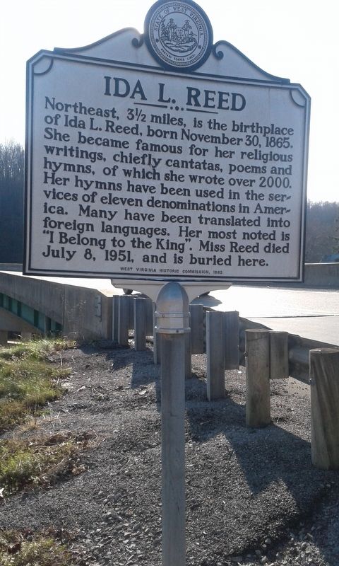
On Winchester Pike (U.S. 11) just north of Old Mill Road, on the right when traveling north.
On Runnymeade Road (County Route 26) at Soldier Drive, on the right when traveling west on Runnymeade Road.
On Runnymeade Road (County Road 26) 0.4 miles west of Goldmiller Road (County Road 24), on the left when traveling west.
On Dominion Road, 0.1 miles south of Gerrardstown Road, on the left when traveling south.
On Gerrardstown Road (West Virginia Route 51) 0.1 miles east of Reunion Corner Road, on the left when traveling west.
On Baptist Church Alley, 0.1 miles south of Geraldstown Road (West Virginia Highway 51).
On Hedgesville Road (West Virginia Route 9) near Mt. Zion Street, on the right.
On Zion Street just north of East Main Street (West Virginia Route 9), on the right when traveling north.
On Potato Hill Street just north of Town Spring Street, on the left when traveling north.
On West South Street east of South Maple Avenue, on the left when traveling west.
On South Spring Street at East John Street, on the left when traveling south on South Spring Street.
Paid Advertisement
On West South Street, 0.1 miles west of South Queen Street, on the right when traveling west.
On South Queen Street (West Virginia Route 9) north of East John Street, on the right when traveling south.
On Tuscarora Pike (County Route 15) west of Lost Road (County Route 13/1), on the left when traveling west.
On West Virginia Route 85, 0.1 miles north of Country Estates Road, on the left when traveling south.
On Main Street (West Virginia Route 67), on the right when traveling west. Reported missing.
On Main Street at Church Street, on the right when traveling east on Main Street.
On Main Street (West Virginia Route 67), on the right when traveling east. Reported missing.
Near Eldersville Road (West Virginia Route 27) at St. John's Road, on the right when traveling west.
On Charles Street at 11th Street, on the left when traveling north on Charles Street.
On Guyan Street north of 5th Avenue, on the right when traveling north.
On 11th Street at Veterans Memorial Boulevard (U.S. 60), on the left when traveling south on 11th Street.
On James River Turnpike Road (County Route 25) 1.6 miles Midland Trail (U.S. 60), on the right when traveling east.
On Greenbrier Road (County Route 17) 2.2 miles west of Patterson Fork Road (County Route 29) when traveling west.
On Greenbrier Road (County Route 17) 0.9 miles west of Patterson Fork Road (County Route 29), on the right when traveling west.
Paid Advertisement
On Rotan Street (Local Road 19/15) at Austin Street and King Avenue, on the right when traveling south on Rotan Street.
On Stanford Road (West Virginia Route 41) 0.2 miles north of County Road 41/27, on the right when traveling north.
On Little Kanawha Parkway, 0.1 miles east of Job Run Road (County Road 35/4), on the left when traveling east.
On Little Kanawha Parkway (West Virginia Route 5) 0.1 miles east of Job Run Road (Route 35/4), on the right when traveling east.
On Virginia Avenue (West Virginia Route 55) east of Main Street (U.S. 220), on the right when traveling east. Reported missing.
On Riverview Avenue (West Virginia Route 12) at Monroe Street, on the right when traveling east on Riverview Avenue.
On North Monroe Street north of Walnut Avenue, on the right when traveling north.
On Church Street south of Foster Street, on the left when traveling south.
On Courtney Drive at Washington Street (U.S. 60) on Courtney Drive.
On U.S. 60, on the left when traveling west.
On Church Street south of Foster Street, on the left when traveling south.
On Washington Street (U.S. 60) near Livesay Street, on the right when traveling west.
On Kanawha Avenue (U.S. 60) 0.1 miles east of S. Sewell Street (West Virginia Route 20), on the left when traveling east.
On Midland Trail W Road (U.S. 60) near junction with Sam Black Church Road (County Route 60/5), on the right when traveling east.
On Northwestern Turnpike (U.S. 50) just west of West Gravel Lane, on the right when traveling west.
Paid Advertisement
On North High Street (West Virginia Route 28) just south of Larson Place, on the left when traveling north.
On West Rosemary Lane at North Marsham Street, on the right when traveling west on West Rosemary Lane.
On South High Street just north of East Gravel Lane, on the right when traveling south.
On Three Churches Hollow Road at Jersey Mountain Road on Three Churches Hollow Road.
On North River Avenue at Jefferson Avenue, on the right when traveling south on North River Avenue.
On South 17th Street at Pennsylvania Avenue (West Virginia Route 105), on the right when traveling west on South 17th Street.
On West Virginia Route 259 at Lower Cove Road (Route 59), on the right when traveling south on State Route 259.
On South Main Street (U.S. 220) at Winchester Avenue, on the right when traveling north on South Main Street.
On South Main Street (U.S. 220) at Winchester Avenue (Old West Virginia Route 55), on the left when traveling south on South Main Street.
On North Main Street (U.S. 220) just south of Williams Street, on the right when traveling south.
On South Fork Road (County Route 7) 16.7 miles north of U.S. 33, on the right when traveling north.
Near Benedum Drive (West Virginia Route 131) 0.1 miles north of Northwestern Turnpike (U.S. 50), on the right when traveling north.
Near Benedum Drive (West Virginia Route 131) south of Park Avenue, on the right when traveling north.
On Enterprise Road (County Road 19/2) just east of U.S. 19, on the right when traveling east.
On Buckhannon Pike (West Virginia Route 20) 0.4 miles south of Cost Avenue (West Virginia Route 58), on the left when traveling south. Reported missing.
On Ravenswood Road (Route 68) 0.2 miles south of County Road 4/8, on the right when traveling north.
Paid Advertisement
On Walnut Street at Ann Street, on the right when traveling west on Walnut Street.
On Court Street North at North Street West, on the left when traveling north on Court Street North.
On West Washington Street (Alternate U.S. 340) just east of Jefferson Street, on the right when traveling east.
On South West Street at West Congress Street, on the right when traveling south on South West Street.
On South West Street at West Congress Street, on the right when traveling south on South West Street. Reported permanently removed.
On Middleway Pike (West Virginia Route 51) east of North Ridge Drive. Reported missing.
On E Congress Street at S Church Street, on the right when traveling east on E Congress Street.
On Fillmore Street at Storer College Place, on the right when traveling east on Fillmore Street. Reported missing.
On Fillmore Street east of Columbia Street, on the right when traveling east.
On Washington Street (Alternate U.S. 340) just west of Zachary Taylor Street, on the right when traveling west.
Near Church Street, on the right when traveling south.
On Washington Street (Business U.S. 340) east of Boundary Street, on the left when traveling east.
On Church Street, on the right when traveling east.
Near Church Street just west of Public Way, on the right when traveling east.
On East Street (County Road 1/8) 0.1 miles north of Grace Street (County Road 1/8), on the left when traveling north.
On South Fairfax Boulevard (West Virginia Route 115) at Mildred Street and 4th Avenue, in the median on South Fairfax Boulevard.
Paid Advertisement
On North Church Street (County Road 480/1) just north of Old Queen Alley, on the right when traveling north.
On W. German Street near Church Street, on the right when traveling east.
On West German Street at South Church Street, on the right when traveling east on West German Street.
On Stubb Road just south of West Dupont Avenue (County Road 60/12), on the left when traveling south.
On U.S. 60, 0.3 miles east of Kellys Creek Road (County Route 81), on the right when traveling east.
On East Dupont Avenue (U.S. 60) at Woodmont Cemetery Drive, on the right when traveling south on East Dupont Avenue.
On East Dupont Avenue (U.S. 60) at Woodmont Cemetery Drive, on the right when traveling south on East Dupont Avenue.
On Quarrier Street just west of Morris Street, on the right when traveling west.
On Morris Street south of Quarrier Street, on the right when traveling south.
On Virginia Street East east of Leon Sullivan Way, on the left when traveling north.
On Virginia Street East, on the right when traveling south.
On Kanawha Boulevard East west of Ruffner Avenue, on the right when traveling west.
On Quarrier Street at Leon Sullivan Way, on the left when traveling north on Quarrier Street.
On 1st Avenue just north of 3rd Avenue (West Virginia Route 61), on the left when traveling north.
On Malden Drive south of Wise Drive, on the right when traveling north.
Paid Advertisement
On Georges Drive at Malden Drive (County Road 60/6), on the right when traveling west on Georges Drive.
On North Pinch Road (County Route 47) close to Reunion Road, on the left when traveling north.
On 2nd Street just north of 6th Avenue, on the right when traveling south.
On B Street, 0.1 miles south of 4th Street, on the right when traveling south.
On Main Street (U.S. 19) at Depot Street, on the right when traveling north on Main Street.
215 entries matched your criteria. The first 100 are listed above.
Next 100 ⊳