By Syd Whittle, April 9, 2008
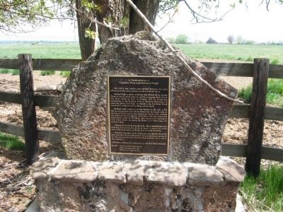
In Commemoration of Captain Dick and Richard Pugh Marker
| On McArthur Road (Route A19) south of Soldier Mountain Road, on the right when traveling north. |
| On Copco Road at Oregon Road, on the left when traveling east on Copco Road. |
| Near Hill Road (Route 10) near County Route 120, on the left when traveling south. |
| Near County Route 120 near Wildlife Refuge Tour Road, on the right when traveling west. |
| Near County Route 120 near Hill Road (County Route 10), on the right when traveling east. |
| Near County Route 120 near Hill Road (County Route 10), on the left when traveling west. |
| On County Route 120 near Hill Road (County Route 10), on the left when traveling west. |
| Near Hill Road, on the left when traveling south. |
| Near Hill Road (County Road 10). |
| On Hill Road (County Road 10), on the left when traveling south. |
| Near Volcanic Legacy Scenic Byway, on the right when traveling south. |
| On Balch Park Road, 12 miles east of CA-190 (California Highway 190), on the right when traveling east. |
| On North Santa Fe Street south of East Race Avenue, on the right when traveling south. |
| Near Mono Way (California Route 108) 15.2 miles east of Herring Creek Lane. |
| Near State Highway 159, on the right when traveling south. |
| On Sherman Street. Reported permanently removed. |
| Near 15th Street near Arapahoe Street, on the right when traveling west. |
| On West 8th Avenue at Vallejo Street, on the left when traveling east on West 8th Avenue. |
| On Colorado Street (State Highway 86). |
| On Colorado Street (County Route 86), on the right when traveling west. |
| On County Highway 2 at County Highway 20, on the left when traveling north on County Highway 2. |
| On Washington Avenue Bridge, on the right when traveling north. |
| Near Lookout Mountain Road (Lariat Loop). |
| Near County Highway W east of Chief White Antelope Way. |
| Near County Highway W east of Chief White Antelope Way. |
| Near County Highway W east of Chief White Antelope Way. |
| Near County Highway W east of Chief White Antelope Way. |
| Near County Highway W east of Chief White Antelope Way. |
| Near County Highway W east of Chief White Antelope Way. |
| Near County Highway W west of County Highway 56. |
| Near County Highway W east of Chief White Antelope Way. |
| Near County Highway W east of Chief White Antelope Way. |
| Near County Highway W east of Chief White Antelope Way. |
| Near County Highway W east of Chief White Antelope Way. |
| Near County Highway W just east of Chief White Antelope Way. |
| Near County Highway W east of Chief White Antelope Way. |
| Near County Highway W east of Chief White Antelope Way. |
| Near County Road W, 1.3 miles east of County Road 54. |
| Near County Highway W east of Chief White Antelope Way. |
| On Unnamed entrance road north of County Road W, in the median. |
| Near County Highway W east of Chief White Antelope Way. |
| Near E 15th Street (U.S. 287) 0.1 miles east of Maine Street, on the left when traveling east. |
| Near County Road W, 1.3 miles east of County Road 54. Reported permanently removed. |
| Near County Road W, 1.3 miles east of County Road 54. Reported permanently removed. |
| Near County Road W, 1.3 miles east of County Road 54. Reported permanently removed. |
| Near County Road W, 1.3 miles east of County Road 54. Reported permanently removed. |
| Near County Road W, 1.3 miles east of County Road 54. Reported permanently removed. |
| On County Road W, 1.3 miles east of County Road 54. Reported permanently removed. |
| On County Highway 250, 0.5 miles east of U.S. 550, on the left when traveling east. |
| Near 4th Street (U.S. 287) west of 7th Avenue, on the right when traveling west. |
| On Grand Army of the Republic Highway (State Highway 6) at County Road 2.5, on the right when traveling east on Grand Army of the Republic Highway. |
| On Colorado Route 63 north of County Road 16, on the left when traveling north. |
| On County Road 370 near U.S. 6. |
| Near Main Street (U.S. 50) at E. Beech Street, on the right when traveling north. |
| Near County Highway 35.25 south of County Highway JJ. |
| Near Main Street at 6th Street, on the right when traveling west. |
| On Main Street at 6th Street, on the right when traveling west on Main Street. |
| On Colorado Route 64, 2 miles west of Loop Colorado Highway 13, on the left when traveling west. |
| On West 1st Street (U.S. 34) at Custer Avenue, on the left when traveling west on West 1st Street. |
| Near County Road KK south of County Road 20.7. |
| On U.S. 34 at County Highway J, on the right when traveling west on U.S. 34. |
| On College Street east of Bridge Street (Connecticut Route 154) when traveling west. |
| Near Gulf Street at Cherry Street, on the right when traveling south. |
| On Jewish War Veterans Memorial Highway (Interstate 95) 0.5 miles east of Mystic Street (Connecticut Route 614), on the right when traveling east. |
| Near Greenmanville Avenue (Connecticut Route 27) north of Hinckley Street, on the left when traveling north. |
| On Route 169, on the right when traveling south. |
| On Martin Luther King Jr. Boulevard North just east of East Water Street, in the median. |
| On South Walnut Street just south of Causey Avenue (Delaware Route 36), on the left when traveling south. |
| On Massachusetts Avenue Northwest at 16th Street Northwest, in the median on Massachusetts Avenue Northwest. |
| On Main Drive Northwest at 14th Street Northwest, in the median on Main Drive Northwest. |
| On Newton Street Northwest near 18th Street Northwest. |
| On Marshall Drive Northwest east of MacArthur Drive Northwest, on the right when traveling east. |
| On Sheridan Circle Northwest at 23rd Street Northwest, on the left when traveling east on Sheridan Circle Northwest. |
| Near E Street Southeast, 0.1 miles east of Potomac Avenue Southeast, on the right when traveling east. |
| Near Southeast 15th Street (Camp Ranch Road), 0.4 miles south of Southeast 41st Avenue when traveling south. |
| On West Newberry Road (State Road 26) near NW 91st Street, on the right when traveling east. |
| Near Northwest 34th Street (Florida Route 121) at Northwest 10th Avenue, on the right when traveling north. |
| Near Southeast 21st Avenue at Southeast 4th Street, on the left when traveling west. |
| On E. University Avenue, on the right when traveling west. |
| On Union Road, 0.1 miles east of Newell Drive, on the right when traveling east. |
| On Southeast Tuscawilla Road, 0.3 miles west of U.S. 441, on the right when traveling west. |
| On NE 1st Street (County Road 25A) near N.E. Peach Avenue, on the right when traveling west. |
| On Southeast Tuscawilla Road, 0.3 miles west of U.S. 441, on the right when traveling west. |
| On Southeast Tuscawilla Road, 0.3 miles west of U.S. 441, on the right when traveling west. |
| On County Road 234 at County Road 2082, on the left when traveling north on County Road 234. |
| On South Lowder Street, 0.1 miles south of W Railroad Avenue. |
| On West King Street (State Road 520) west of South Cocoa Boulevard (U.S. 1), on the right when traveling west. |
| Near West New Haven Avenue (U.S. 192) at McClain Drive, on the right when traveling west. |
| Near Murrell Road, 0.6 miles south of North Wickham Road, on the left when traveling south. |
| On Courtenay Parkway North (State Road 3) 0.3 miles north of Biolab Road, on the left when traveling north. |
| Near Bryan Place at Cooley Avenue. |
| Near Southeast 6th Avenue at Southeast 4th Avenue, on the right when traveling south. |
| On Southwest 11th Avenue at Southwest 4th Street, on the left when traveling south on Southwest 11th Avenue. |
| Near Seabreeze Boulevard (Florida Route A1A) at Sahia Mar. |
| On Chipola Street (County Route 274) 1.3 miles west of North Main Street (Florida Route 71), on the right when traveling west. Reported missing. |
| On Central Avenue (State Road 20) at Main Street (State Road 71), on the right when traveling west on Central Avenue. |
| On East Central Avenue (State Road 20) at Main Street (State Road 71), on the right when traveling west on East Central Avenue. |
2894 entries matched your criteria. Entries 201 through 300 are listed above.
⊲ Previous 100 —
Next 100 ⊳