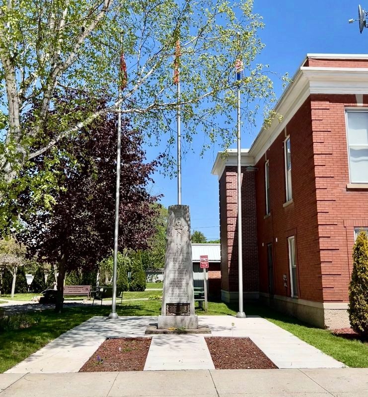
In Flanders fields the poppies blow
between the crosses row on row
1914 - 1918
Their name endureth for evermore
Our Honoured Dead
Bert Lawrence ·
Wm Little ·
Hugh Mccall ·
Cliff Miller ·
Kenneth Parker ·
Fred Newman ·
Ernest . . . — — Map (db m273197) WM
In 1851 George Brown, founder of the Toronto Globe and one of Canada's Fathers of Confederation, purchased about 4000 acres in this vicinity. The Great Western Railway ran through his property in 1855 and that year a station and a post office were . . . — — Map (db m272395) HM
Upon sighting American war ships at the mouth of the Thames River on October 1, 1813, the British Army boarded scows and bateaux near this site. One by one, the boats and their cargo were pulled across the river to their next encampment site at . . . — — Map (db m184677) HM
While British Army was encamped at Dolsen's, Procter travelled to Fairfield to investigate the site as a defensive position. At Tecumseh's urging, and learning that the Americans were closing rapidly, Colonel Warburton, Procter's . . . — — Map (db m309267) HM
East of the Forks, the Thames River becomes shallower and not navigable for larger ships. With the American forces close behind, the British vessels were threatened with capture. One cargo ship, probably the Miamis, had already been set on fire . . . — — Map (db m71398) HM
The Carnegie library, which stood on this site from 1903 to 1967, was made possible by a $15,000 grant from the foundation of American philanthropist, Andrew Carnegie. This attractive building, constructed by J.C. Wilson and Sons and designed in the . . . — — Map (db m306255) HM
There were many casualties at the skirmish at the Forks. Although we do not presently know the identities of the warriors who were killed, we do know that two Kentucky men in Colonel Johnson's Mounted Infantry lost their lives at this . . . — — Map (db m309268) HM
The Chatham Armoury was constructed in 1905 as a result of reform and expansion of the volunteer militia. The first unit to occupy the Armoury was the 24th Kent Regiment that was formed in 1901. It was the centre for local recruitment and training . . . — — Map (db m71382) HM
On this site a blockhouse was constructed in 1794 by order of Lieutenant-Governor John Graves Simcoe. He planned to establish here a small naval arsenal which would form a link in the defences of Upper Canada's western frontier and also draw the . . . — — Map (db m71313) HM
Thomas McCrae was an early settler, innkeeper, and political figure in Raleigh Township along the Thames River. He served as a captain and company commander in the Kent Militia and was present at the capture of Fort Detroit. Family tradition relates . . . — — Map (db m71308) HM
On May 10, 1858, American abolitionist John Brown held the last in a series of clandestine meetings here at First Baptist Church. Brown planned to establish an independent republic within the United States and wage guerrilla war to . . . — — Map (db m71386) HM
In 1847 the Kent District was established and authority was given for the erection of a court house and jail at Chatham. One year later construction began according to plans submitted by the prominent Canadian architect William Thomas. Designed in . . . — — Map (db m198312) HM
In Honour of
All Who Served
in the
Kent Regiment
Since Its Inception
1792
Dedicated on
October 3, 1992
By the
Kent Regiment
Association — — Map (db m285993) WM
This Steam Powered Fire Pumper was built in 1869, at 27 Adelaide Street South, in Chatham Ontario, by the Ronald & Hyslop Company. It was purchased by the City of Chatham and put into service in 1870.
During Canada's Centennial in 1967" the . . . — — Map (db m306004) HM
During the American occupation of the lower Thames, this house was used as a base for U.S. troops. In mid-December 1813, the house was occupied by 39 officers and men of the 26th Regiment led by Lieutenant Larwill.
At the same time, a group of . . . — — Map (db m71310) HM
On October 2, 1813, Tecumseh moved his warriors up-river to the Forks where he had been led to believe that fortifications would be prepared for a full-scale confrontation with harrison's army. When Tecumseh arrived, he was enraged to find no . . . — — Map (db m71335) HM
On this site, Tecumseh, a Shawnee Chief, who was an ally of the British during the War of 1812, fought against American forces on October 4, 1813. Tecumseh was born in 1768 and became an important organizer of native resistance to the spread of . . . — — Map (db m71322) HM
From 1783 until the 1860s, abolitionists in British North America took part in the fight to end slavery both at home and in the United States. Thanks to the determination of colonial officials, anti-slavery organizations, and the thousands of . . . — — Map (db m71391) HM
The Forks of the Thames are formed by the joining of the Thames River and McGregor Creek creating a peninsula that is present day Tecumseh Park in Chatham, Ontario. The strategic importance of the site was recognized by Lieutenant Governor John . . . — — Map (db m71331) HM
The Paw Paw tree (Asimina triloba) is native to the southern, eastern, and mid-western United States and extends to Canada only in the extreme southern part of Ontario. It has the largest edible fruit native to North America. The fruit looks . . . — — Map (db m71405) HM
On this site, in the year 1820, a log house was erected by Chatham's first permanent resident, William Chrysler, great grandfather of Walter P. Chrysler, automobile pioneer and founder of the Chrysler Corporation. — — Map (db m306251) HM
Ace of the beloved Cubs' teams of the '60s and '70s pitched 10 seasons for Chicago spanning three decades. Fergie is the Cubs' all-time leader in strikeouts and games started. Holds the all-time single season record for the Texas Rangers with 25 . . . — — Map (db m306204) HM
Skirmish at McCrae's House
Following the defeat of the British at the Battle of the Thames on October 5, 1813, American forces controlled the Thames Valley west of Moraviantown. In early December a detachment of 3 officers . . . — — Map (db m308407) HM
This house belonged to James Harris and his family, who are believed to be descendants of Weldon Harris, an African American who came to Canada and in 1825 purchased 50 acres on Lot 3, Concession 3 in Camden Township. Weldon Harris made . . . — — Map (db m78404) HM
English
Built in the mid-19th century, this house was the last residence of Josiah Henson and his second wife, Nancy Gambril, who lived in it until Henson’s death in 1883. Henson’s house was substantial in size compared to other . . . — — Map (db m78387) HM
After escaping to Upper Canada from slavery in Kentucky, the Reverend Josiah Henson became a conductor of the Underground Railroad and a force in the abolition movement. The founder of the Black settlement of Dawn, he was also an . . . — — Map (db m78377) HM
This area was once covered in a thick, growth of trees including black walnut, maple, beech, elm and white oak. To make use of these natural resources, Josiah Henson and his sons used donations from benefactors in Boston to build a . . . — — Map (db m78402) HM
Built around 1850, this modest rural church was moved from Mersea Township to this site in the 1960s and is representative of the churches in which Reverend Henson preached while living at Dawn.
Reverend Josiah Henson was most . . . — — Map (db m78388) HM
In the 1830s, the Reverend Josiah Henson and other abolitionists sought ways to provide refugees from slavery with the education and skills they needed to become self-sufficient in Upper Canada. They purchased 200 acres of land here in . . . — — Map (db m78376) HM
In 1846 Daniel van Allen, a Chatham merchant, laid out a town plot on land purchased from Jared Lindsley, the first settler (1825) on the site of Dresden. By 1849 the erection of a steam sawmill, and the operation a grist-mill in the neighbouring . . . — — Map (db m78416) HM
On November 7, 1763 a fleet of small boats carrying nearly 700 officers and men of the 60th and 80th Regiments under Major John Wilkins was forced ashore by a violent storm abut three miles east of this point. The expedition had set out from Niagara . . . — — Map (db m108505) HM
As Lieutenant Colonel James Johnson's horsemen were charging the British front line, his brother, Colonel Richard Johnson led an attack against the First Nations warriors in Backmetack Marsh. The mounted infantry charged the Native left flank led by . . . — — Map (db m233828) HM
In September 1813, during the second year of the War of 1812, the United States won control of Lake Erie, cutting British supply lines with the east and forcing the British to withdraw from the Detroit River region. Then, on October 5, . . . — — Map (db m78367) HM
The Moravians or "Bohemian Brethren" were a protestant sect that originated in the 1400s in Moravia and Bohemia, the present day Czech Republic. They faced persecution in their homeland and in 1722 many moved to Saxony (now part of Germany) where . . . — — Map (db m72448) HM
(Front of monument)
Fairfield on the Thames / Fairfield sur la Thames
Here stood the village of Fairfield, destroyed by invading American forces following the Battle of the Thames. , 5th October, 1813.
Its inhabitants, Delaware . . . — — Map (db m116758) HM
Jacques (James) Baby 1763-1833: A member of the Legislative and Executive Council for Upper Canada, judge for the Western District, and in command of the 1st Kent Militia, Baby was captured by the Americans at the Battle of the Thames.
Billy . . . — — Map (db m71415) HM
Makataimeshekiakiak, Black Hawk, 1767-1838: A Sauk war leader and experienced warrior, Blackhawk was a veteran of the Battles of Fort Meigs and Fort Stephenson. Although he left the war for a period of time, he rejoined the British, and scholars . . . — — Map (db m71418) HM
Shabbona 1775-1859: A Potawatomi chief, grand nephew of Pontiac, and veteran of Tippecanoe, Shabbona was an accomplished warrior and strong supporter of Tecumseh. He persuaded many natives to join the confederacy.
Sou-veh-hoo-wah, Split Log, . . . — — Map (db m71419) HM
John Adair 1757-1840: Pioneer, soldier, and statesman, Adair was a veteran of the American Revolution, was 8th governor of Kentucky, and represented that state in both the U.S. House of Representatives and the Senate. He fought at the Battle of the . . . — — Map (db m72381) HM
James Johnson 1774-1826: The brother of Richard Johnson, James was elected as a Kentucky State senator in 1808. He served as a lieutenant colonel in Johnson's Mounted Infantry and led the charge on the British lines at the Battle of the Thames along . . . — — Map (db m72385) HM
Isaac Shelby 1750-1826: Shelby was the 1st and 5th governor of Kentucky and a veteran of the American Revolution. As governor and at 63years of age, Shelby personally led the Kentucky Militia at the Battle of the Thames.
Tarhe 1742-1816: A . . . — — Map (db m309270) HM
By the early morning of October 5, 1813, the American Army had forded the Thames River and was advancing quickly. The British rearguard was able to destroy Cornwall's mill, west of Sherman's farm (present-day Thamesville, Ontario) but not the mill . . . — — Map (db m71413) HM
Born in a Shawnee village in what is now Ohio, Tecumseh became in the 1770s co-leader with his brother, the Prophet, of a movement to restore and preserve traditional Indian values. He believed a union of all the western tribes to drive . . . — — Map (db m309269) HM
Many of the men of the 41st Regiment had been stationed in Canada for 13 years. By October 5, 1813, they had not been paid for 6 to 9 months; they lacked tents and blankets; their uniforms were in rags; they were plagued by a variety of diseases; . . . — — Map (db m72393) HM
Robert McAfee, a soldier in Colonel Johnson's Mounted Regiment, kept a journal of his experiences, and wrote on October 7, 1813:
Spent the day in collecting in plunder ... Colonel Owings Regiment of Regulars came up and took charge of the . . . — — Map (db m72414) HM
At some point during the attack on Backmetack Marsh, Tecumseh was fatally shot. As word spread of their leader's death, one American account tells of the warriors giving, "the loudest yells I ever heard from human beings and that ended the fight." . . . — — Map (db m72405) HM
Some British officers involved reported that, due to the proximity of the enemy and the fact that the troops were exhausted and hungry, they were unable to outpace the American mounted units to Fairfield. Another theory is that Procter sought to . . . — — Map (db m71414) HM
The Sydenham Glass Company was established in 1894 by Captain William Taylor. He envisioned using sand found nearby on the banks of the Sydenham River, but it turned out that the local sand was unsuitable for glass making. However, the river access . . . — — Map (db m272469) HM
One of the foremost 19th century arms inventors, Lee was born in Scotland. In 1836 his family came to Canada and settled at Galt. Lee was trained in his father's profession of watchmaker and jeweller, before moving to Wisconsin about 1858, where he . . . — — Map (db m272462) HM
The Chippewa surrendered their lands in this area by treaty in 1796. The first European presence in the area was Lord Selkirk's nearby Baldoon Settlement, founded in 1804. It failed because of its poor location, but some of the settlers . . . — — Map (db m272407) HM
Near this site was the homestead of John and
Nancy McDonald (MacDonald), members of Lord
Selkirk's 1804 settlement. The family home was
the scene of many strange events. In the 1830's
an aged neighbor woman had cast a spell of
bad fortune on . . . — — Map (db m272488) HM
On September 5, 1804 fifteen families of Scottish
emigrants numbering some ninety persons landed near this site. Named after an estate in Scotland, the settlement was sponsored by Lord Selkirk who later founded the Red River Colony. The low-lying . . . — — Map (db m272487) HM
In honoured memory of
the men of
Aylmer and Malahide
who fought and died
for King and Country
in the Great War
1914-1918
(names not transcribed) — — Map (db m273238) WM
In October, 1817, John Van Patter, an emigrant from New York State, obtained 200 acres of land and became the first settler on the site of Aylmer. During the 1830's a general store was opened and village lots sold. Originally called Tray, in 1835 it . . . — — Map (db m255222) HM
Burwell's Corners is named after Mahlon Burwell, the son of United Empire Loyalists, who came to the Talbot Settlement in 1809 at the request of Thomas Talbot, a colonial land administrator. Mahlon Burwell surveyed much of the land from Essex to . . . — — Map (db m255427) HM
Burwell, a surveyor, was a militia officer during the War of 1812 making him a prime target for enemy raiders who plundered Southwestern Ontario unopposed for most of the last year of the war. He moved to Port Talbot in 1809 with his family to . . . — — Map (db m255424) HM
Col. Thomas Talbot landed immediately south of this location in May of 1803. From here, he would, for the next 30 years, direct the settlement of an immense area stretching from Windsor to Delhi. When he arrived
there was nothing but dense bush, . . . — — Map (db m253447) HM
No. 4 Bombing and Gunnery School was a unit of the British Commonwealth Air Training Plan. The Plan, from April 29, 1940 to March 15, 1945, graduated over 130,000 air crew, of which 73,000 were Canadians. No. 4 B&GS consisted of the main station at . . . — — Map (db m253435) HM WM
The Talbot Settlement
The settlement begun in May 1803 by Thomas Talbot was despite the controversial practices of its founder one of the most successful in Upper Canada. Major roads were constructed throughout the settlement and . . . — — Map (db m253442) HM
John Kenneth Galbraith was born here October 15, 1908. Educated at the Ontario Agricultural College and the University of California, Berkeley, he joined the faculty of Harvard University in 1934. During World War II he administered price controls . . . — — Map (db m253523) HM
Southwold Earthworks
This prehistoric site was once a fortified village occupied by the Neutral Indians between about 1500 and 1650 A.D. An earth and palisade wall, later strengthened by a second wall, protected a cluster of . . . — — Map (db m255420) HM
Southwold: The remains of an indian village
Members of the Neutral Amerindian group built a village surrounded by a double palisade here, in Southwold, around the year 1500, it is not known how long the site was occupied, but it . . . — — Map (db m255419) HM
Near here, Sir William Johnson, Superintendent
of Indian Affairs for the British colonies,
made camp while journeying from New York
to negotiate with native tribes in the Detroit
area. Upon news from General Amherst of
the surrender of Belle . . . — — Map (db m255238) HM
Born of Loyalist parents, Burwell became a deputy-surveyor in 1809 and was instructed to lay out the Talbot road for settlement. He was granted 600 acres of land in Southwold Township where he settled in 1815. A close associate of Col. Thomas . . . — — Map (db m252695) HM
The Port Burwell lighthouse was constructed in 1840. It was part of a national network of light stations equipped with beacon lights to warn or guide ships at sea. The Port Burwell light was used to aid navigation and commercial shipping of local . . . — — Map (db m198238) HM
This frame building was begun in 1836 and completed the following year. An example of simple early Gothic Revival architecture, this church was constructed as a result of the interest and substantial financial assistance of Lieutenant-Colonel Mahlon . . . — — Map (db m252721) HM
Aldborough Pioneers
In the year 1816, Alexander Forbes, Archibald Gillies and Neil Haggart, natives of Scotland, moved from Caledonia, New York and were each granted fifty acres of land by Colonel Talbot in Concessions 12 and 13 of Aldborough . . . — — Map (db m255531) HM
Following the burning of the mill at Port Talbot
in 1814 by American forces after the War of 1812
Colonel Talbot donated this stone to Peter McKellar
to use in the valley mill he was building on Sixteen
Mile Creek in Aldborough west of New . . . — — Map (db m255521) HM
With the British loss at the Battle of Lake Erie in September of 1813, supplies could no longer be brought by boat to Forts Detroit and Malden on the Detroit River. With many Native Allies to feed, the British were forced to withdraw along the . . . — — Map (db m255492) HM
In 1921 the Aldborough Old Boys Association constructed this summer dance pavilion.
The first dance was held Wednesday, August 3, 1921 with the music supplied by a local group:
Vernon "Hubby" Morris - violin, Ada (Johnson) Murray - piano, and . . . — — Map (db m255547) HM
Originally, Port Stanley residents had to use small boats to cross Kettle Creek. In 1843, the Province of Canada built a swing bridge across the Harbour. This bridge would allow vessels to travel north of the bridge if the creek was deepened . . . — — Map (db m253079) HM
Port Stanley was not yet settled when the War of 1812 broke out, however, the land on which it sits had been granted to John Bostwick, a native of Massachusetts, then living in the Long Point region. He had come to Upper Canada with his brother in . . . — — Map (db m252879) HM
This tablet erected in 1939 commemorates more than one hundred years of development of Port Stanley harbour
beginning with the launching of schooner “Sterling” in 1827 of 90 tons burthen and commencement of first harbour pier.
The steamer “Thames" . . . — — Map (db m253080) HM
Born in Massachusetts, Bostwick came as a child to Norfolk County. He was appointed high constable of the London District in 1800 and sheriff in 1805. A deputy surveyor, he laid out some of the earliest roads in the Talbot Settlement and in 1804 was . . . — — Map (db m284031) HM
Kettle Creek was called by the Iroquois the "Kanagio", by the Ojibwas the "Akiksibi", by the French the "Rivière Tonti". Among early visitors were: Louis Jolliet, September, 1669; Dollier and Galinée, April, 1670; the Celoron expedition, . . . — — Map (db m252912) HM
The London and Port Stanley Railroad
After the Great Western Railway reached London in 1853, local businessmen and politicians began promoting a competitive line south to Lake Erie. The London and Port Stanley Railway began . . . — — Map (db m253034) HM
H E L L O
.... . ._.. ._.. _ _ _
In the early years of the last century, if you wanted your cousin in the Northwest Territories to know that his Aunt Millie had taken a turn for the worse you would probably have headed for the . . . — — Map (db m253428) HM
A modest example of Greek Revival architecture and suited to the plain tastes of a Quaker-influenced community, this house was built in 1855. It is characterized by a symmetrical facade, and a centre doorway with pilasters and a dentiled cornice. . . . — — Map (db m260329) HM
This cairn was first erected in 1935 on the farm of Eli Mann by the Boy Scouts of St. Thomas. Eli had hosted all of the scout camps and activities on his farm for many years. In 1935, he died as a result of a goring by his bull and the scouts built . . . — — Map (db m260321) HM
Hiram came to Sparta in 1830 at the age of 19 with $5.00 and a tailor's goose (a 21 lb. iron for ironing woolen garments). He set up as a tailor on this site, building the house in 1842 for himself, his wife Sarah (Mills) and their two sons, Isaac . . . — — Map (db m260314) HM
The Doan family were the first settlers in the Corners (later named Sparta). Jonathan Doan came in 1813 from the Niagara Region and settled just west of the current village. His son Josfa took part in the 1837 Rebellion and fled to the United . . . — — Map (db m260218) HM
In the late 1800s, excessive drinking had become a major concern in the village of Sparta and a Temperance Society was formed with leadership from the Baptist minister, Rev. J.J. Baker, the Methodist minister, Rev.
W.H. Graham and Dr. G.A. Shannon. . . . — — Map (db m260312) HM
This yellow brick building was constructed in 1886, and served as a Methodist Church until
1925 when it became a part of the new United Church of Canada. After substantial fundraising and local participation in its construction, it opened to great . . . — — Map (db m260359) HM
Built in the 1840's adjacent to the Mills Hotel (Sparta House), the Abbey was first used as an inn. For a brief time, The True Teller, a Sparta newspaper was published in this building. R.J. Stratton operated a furniture and coffin business . . . — — Map (db m260357) HM
Built by Henry Yarwood and sold to John Eakins.
The years 1840-1880 marked the prime years of the Sparta Settlement.
As the centre of the agricultural community, Sparta had good supplies of water and power supplied by numerous mills on Mill and . . . — — Map (db m260215) HM
As the War of 1812 began Sir Isaac Brock, Upper Canada's military governor, called all men for the militia to assist with the defense of the colony. Because of their historic Peace Testimony, and the understanding established when they came to . . . — — Map (db m255244) HM
This property was originally settled by John Kipp, a Quaker who came up from Pennsylvania after the War of 1812, at the urging of Jonathan Doan. He began this home between 1819 and 1820. Early Quaker Meetings were held here and at Elias Moore's home . . . — — Map (db m260361) HM
David Mills erected this finely built hotel in the American Colonial style: it had double verandas and classical proportions with a large ballroom on the second floor. It features dentils under the eaves, eave returns, a boomtown, pilastered doorway . . . — — Map (db m260216) HM
This area of Ontario was originally inhabited by the Attawandarons (Neutrals), but they were dispersed by the conflict between the Hurons and the Iroquois two hundred years before Europeans came to the area. In 1813 Jonathan Doan, a Quaker came . . . — — Map (db m255291) HM
This hotel was built in the 1840's by Hitchcock and sold to Isaac Moore who renamed it Elgín House after the governor of the day. Later the Elgin became Ontario House in 1872. This hotel seemed to have the better business than the other hotels in . . . — — Map (db m260358) HM
Here is one of the pioneer necessities of any village- the blacksmith's shop, which was built by a Mr. Keller from England.
A pit was dug in the clay bank, water added, straw scattered on this and oxen tramped down the mixture which was then built . . . — — Map (db m260355) HM
In memory of
the men of
Springfield and
South Dorchester
who fell -
and in honour of
those who served in
the Great War
1914-1918
1939-1945 — — Map (db m273258) WM
About 1850, some ten years after this area was settled, a school and a Methodist meeting house were erected here on the town line between the Townships of South Dorchester and Malahide.
Shortly afterwards a post-office named Clunas was opened, with . . . — — Map (db m255220) HM
Emigrating from New York State to the Long Point Settlement in 1802, Rapelje later received 200 acres of land on the south side of the Talbot Road at Kettle Creek. He settled here with his family in 1810. A veteran of Lundy's Lane and other battles . . . — — Map (db m255828) HM
Founder of the Talbot Settlement, he was born at Castle Malahide, Ireland, a member of the Anglo-Irish nobility. In 1803, after serving in the British Army, and on Simcoe's staff, he was granted 5,000 acres in this region and settled in Dunwich . . . — — Map (db m255637) HM
This house was built in 1848 by Dr. Elijah Duncombe brother of Dr. Charles Duncombe. The latter, born in Connecticut, came to Upper Canada in 1819 and settled on this property shortly thereafter.
In 1824, with Dr. John Rolph, he opened at St. . . . — — Map (db m255573) HM
The Elgin Registry Office was built in 1874 during a formative period (1870 to 1886) of constructing separate buildings for the registry offices. A standard design was developed by the Ontario Department of Public Works for registry office . . . — — Map (db m255730) HM
The former Governor's residence was a two-storey, yellow-brick, Queen Anne-style house. It sat at the south-west corner of the Elgin County Courthouse, facing west towards Stanley Street and the Kettle Creek river valley. The house was . . . — — Map (db m255655) HM
The Provisional Elgin County Council accepted a site for the courthouse and jail from a local landowner, Benjamin Drake. The site was conveyed to Queen Victoria for county and district buildings in October of 1848. During the planning of . . . — — Map (db m255656) HM
532 entries matched your criteria. The first 100 are listed above. Next 100 ⊳