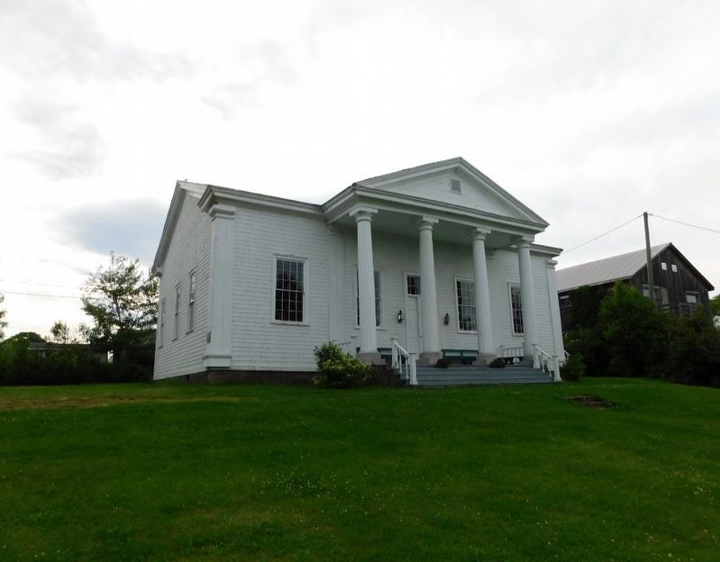
Queen's County Courthouse 1836
Constructed by local builder John Glass to plans furnished by John Cunningham, this impressive Neo-classical building served as the county seat of justice for over one hundred twenty-five years. . . . — — Map (db m286172) HM
Born here in 1818, Tilley was first elected M.L.A. for Saint
John in 1850 and subsequently served on the Executive
Council and as leader of the provincial government. A delegate to the Charlottetown, Québec and London Conferences,
he . . . — — Map (db m302723) HM
Sir Samuel Leonard Tilley (1818-1896), Father of Confederation, was
born and spent his boyhood in this house which had been bought by his
grandfather in 1805. Built in the 1780's by Dr. S. Stickles, the house is
representative of many . . . — — Map (db m302722) HM
Français:
Né à Saint-Louis-de-Kent et ordonné prêtre en 1870, Mgr Richard fut l'une des figures de proue de la renaissance acadienne. Il stimula la colonisation afin de centrer l'exode yeti les États-Unis, fonda des écoles, des . . . — — Map (db m139702) HM
Français:
À l'automne 1767, les familles Gueguen, Arseneau, Hébert et Bourg reçoivent les premières concessions de terres accordées à des Acadiens après le Grand Dérangement.
En novembre, Cocagne devient la première communauté . . . — — Map (db m139701) HM
In 1881, a group of American businessmen (calling themselves the Campobello Company) purchased most of Campobello Island. In an era of summer-long vacations and great summer resorts, the company hoped, by promoting Campobello's charms, to attract . . . — — Map (db m293334) HM
On this site, in 1885, James Roosevelt, businessman and country gentleman of Hyde Park, New York, built the cottage shown below. The Cottage was intended to be a summer retreat for his wife, Sara Delano, and their son Franklin Delano Roosevelt. . . . — — Map (db m293357) HM
The Campobello hotels welcomed socializing between their guests and the summer cottage owners. Summer colonists and hotel guests exchanged visits and participated in hotel activities such as excursions aboard the company's small steamboats, field . . . — — Map (db m293335) HM
Owners of the Campobello Company hoped to enhance their one million-dollar investment by subdividing their land and selling the smaller lots to hotel guests, island residents, and others. Only a few of the lots were actually sold and built upon. . . . — — Map (db m293339) HM
Although visitors had been coming to the island since 1855, Campobello's summer trade did not really prosper until the 1880s - years of long summer vacations and great resorts. A group of Boston and New York businessmen bought most of the . . . — — Map (db m63639) HM
Friar's Head takes its name from the stone pillar or stack (photo 1) that rises from the beach directly below the observation deck. While occupying Eastport, the British navy was said to have used the stone pillar for target practice, . . . — — Map (db m63629) HM
About 1840, a canal connecting Johnson and South Bays was dug in North Lubec and a dam constructed there to harness tidal energy to power plaster mills. Gypsum (the raw product used to make plaster) and grindstones from the Maritimes were important . . . — — Map (db m54995) HM
Lubec's known history began at a Passamaquoddy Indian encampment at Mill Creek in what came to be called Seward's Neck (now North Lubec). French settlers later came to those shores in the early 1700s, but shortly afterward were driven away by the . . . — — Map (db m55023) HM
[English version]
Built in 1885, the Mulholland Point Lighthouse guided many small coasters and freighters taking the shorter and foul weather-protected route through the narrow passage between Campobello and Lubec. Steamships, carrying freight . . . — — Map (db m54894) HM
Built in 1885, the Mulholland Point Lighthouse (photo 1) served as a guide for the many small coasters and freighters taking the shorter and more foul weather-protected route through the Lubec Narrows. Steamships, such as the . . . — — Map (db m63593) HM
Two of the Campobello Company's founders, Alex S. Porter and Samuel Wells, and several of the luxury hotel visitors, including James Roosevelt and families by the name of Sturgis, Cochrane, Prince, and Pell purchased land and refurbished or . . . — — Map (db m63641) HM
During the years FDR summered on Campobello, the daughter of one of Campobello's summer colonists married Dexter P. Cooper, an eminent American engineer. Cooper studied the tremendous rise and fall of Passamaquoddy Bay's tides and became . . . — — Map (db m63611) HM
Passamaquoddy Bay takes its name from the Native American Passamaquoddy Tribe. The word means People of the Pollock-Spearing Place. The Passamaquoddy have a rich heritage, once occupying much of what is now eastern Maine and western New . . . — — Map (db m63617) HM
The Great Depression 1929-1941
The depression was world-wide. In the U.S., the banking system collapsed and 12.8 million people were unemployed. Hardest hit were youth, minorities, the elderly, and workers in the consumer durables industries. . . . — — Map (db m54783) HM
The Roosevelt Campobello International Park is a unique example of international cooperation - jointly administered, staffed, and funded by the peoples of Canada and the United States. Established by international treaty in 1964, the . . . — — Map (db m293356) HM
Mrs. Lyndon B. Johnson and Mrs. Lester B. Pearson Together opened the Roosevelt Campobello Park on the twenthieth day of August 1964 Lyndon Baines Johnson President of the United States of America and Lester Bowles Pearson Prime Minister of Canada . . . — — Map (db m25394) HM
This house of God has welcomed worshippers for one hundred years or more. In commemoration of this fact this plaque has been presented in 1967
Canada's Centennial
of Confederation Year
1867 - 1967 — — Map (db m54939) HM
To the Glory of God
and the memory of our
Immortal Dead
Howard Mallock • Lawson Searles
Those who served our King and Country
Alison Alexander • Ronald Anthony • Wesley Anthony • George Babcock • Lydie Brown • Manning Brown • Raye . . . — — Map (db m54938) HM
English:
The Grand Dérangement
L’Acadie, established by France in 1604, was a strategically located and highly coveted colony. In 1713, it was handed over to England and renamed Nova Scotia. The foundation of Halifax, in 1749, . . . — — Map (db m80580) HM
English:
Because of the vicissitudes of war, the Acadians, pioneers of this country, were dispersed in 1755. The arrival of Alexis Landry at Ste. Anne de Bocage, soon after 1755, symbolizes the return of the Acadians to their beloved . . . — — Map (db m80579) HM
This commemorative stands on land granted to Daniel Jewett in 1799. Here the village of Jewett’s Mills grew and prospered around a water-powered mill built by Daniel on the Mactaquac Stream. Over the years the mill sawed long lumber, shingles, . . . — — Map (db m137469) HM
Français: « Chances égales pour tous ». Avec cette phrase tout simple, Louis J. Robichaud a changé le cours de l’histoire de l’Acadie et du Nouveau-Brunswick. Il inscrit, pour tout citoyen, de quelque classe qu’il soit, la dignité . . . — — Map (db m151247) HM
Français: Les Acadiens sont les premiers colons européens à s'établir à la baie de Fundy, au début du 17e siècle. Ils transforment le paysage en asséchant des marais salés et en construisant des levées et des aboiteaux pour créer . . . — — Map (db m150975) HM
English: The Grand Dérangement L’Acadie, established by France in 1604, was a strategically located and highly coveted colony. In 1713, it was handed over to England and renamed Nova Scotia. The foundation of Halifax, in 1749, . . . — — Map (db m150940) HM
English: From a start in his family's small sawmill in the 1880s, Archibald came a prominent pioneer of the New Brunswick pulp industry. As the lumber trade fell into decline, he sought new ways to exploit the province's vast forest . . . — — Map (db m137447) HM
This Monument is dedicated by the Village of Rexton in grateful commemoration of 74 years (1925-1999) of continuous medical service provided to the people of Kent County by two physicians and surgeons; Dr. William Francis Kenney and his son, Dr. . . . — — Map (db m150498) HM
English: Edward Hannay, regarded as one of the shrewdest horse traders who ever lived, would never pass by a pedestrian. He would say: "He knows something that we don't know, so pick him up." Ned, as he was widely and more . . . — — Map (db m150505) HM
Connue à l'origine comme « the Yard », la communauté fut fondée en 1825 alors que John Jardine, un constructeur de navire reconnu et respecté, y construisit la première demeure. L'imposante maison se tient encore fièrement debout, rendant hommage au . . . — — Map (db m150502) HM
MacNarin Family History (left panel) In 1817, a Canadian ship, The Dykes, set sail from Scotland for Canada with Capt. Simon Graham in command: On board were lads and lassies from the Scottish towns of Dumfriesshire, Gallowayshire . . . — — Map (db m150643) HM
English: Originally built as the manse for St. Andrew's Church, the imposing house was constructed in 1880 on a half-acre of land donated by William and Margaret Bowser. Church Trustees' minutes of July 6, 1881 record that the . . . — — Map (db m150506) HM
English: Built in 1884 on land given by the Brait family, its construction was under the direction of the community's first Anglican families, the Forsters and the Palmers. The church was consecrated on September 3rd of that year by . . . — — Map (db m150499) HM
English:The BridgesIn the beginning it was the river and the abundance of natural resources in the area that brought the settlers here; but, years later, it would be the building of the bridge across the Richibucto that would . . . — — Map (db m150500) HM
Originally known as "The Yard", the community was established in 1825 when the widely known and well respected shipbuilder John Jardine built the first home here. The stately house still stands as a memorial to the founder of the village. The . . . — — Map (db m150503) HM
English: Shawn Michael Graham was born on February 22, 1968 in Rexton, New Brunswick. He is the eldest child of Alan Graham and Sharon Crothers, and his step-mother Connie Tramley. His family also includes wife Roxanne Reeves, PhD, . . . — — Map (db m150497) HM
English:The MastsIn partnership with the Richibucto River Historical Society, the Kingston Maritime Association was organized in 2003 for the purpose of establishing a means of recognizing and preserving the shipbuilding history . . . — — Map (db m150501) HM
English: The village of Rexton was founded in 1825 and officially incorporated, as a village, in 1966. Rexton's population had reached 908 according to the 1996 census. Rexton is located in Southeastern New Brunswick, near the mouth . . . — — Map (db m150507) HM
English:Wooden Ships and Iron Men During the nineteenth century, New Brunswick's booming shipbuilding industry brought great prosperity to the Richibucto River. More than seventy ships of 500 tons and over were built and . . . — — Map (db m150504) HM
Best known as the Fred B. Edgecombe Dry Goods Store, Albion House was built after a major fire in 1871. The building was leased to Colwell and Jennings Ltd. Home Furnishings in 1920. In 1950 it became the J.D. Creaghan Co. Department Store. Rebuilt . . . — — Map (db m150291) HM
English:
Lumber and railway baron and generous benefactor, Gibson was a pivotal figure in the economy of the Maritimes at a time of transformation and integration within the national economy. A leading entrepreneur in mid-to-late . . . — — Map (db m139997) HM
English: Fredericton's Changing of the Guard ceremony commemorates the birth of the Canadian Army in Officers' Square in 1883. Following the formation of the Dominion of Canada in 1867 and the departure of British Forces, the . . . — — Map (db m152399) HM
English: Canada's professional army was born on this site, here in Fredericton in 1883, with the formation of the Infantry School Corps. Sixteen years prior, in 1867, the Dominion of Canada was formed when the colonies of British . . . — — Map (db m152396) HM
English:
Born in Fredericton, Fisher practised law before entering politics. Excepting the period 1850-1854 he represented York as a member of the Legislature continuously from 1837 until his retirement in 1868. Entering the . . . — — Map (db m139900) HM
English: Local Man Saves 200 Soldiers in the War of 1812 Courage and heroism are epitomized by Fredericton's Charles Rainsford, who led a risky mission to secure rations for a storm-stayed military regiment during an epic . . . — — Map (db m152398) HM
English:
Christ Church Cathedral, begun in 1845, is one of the best and earliest examples of the Gothic Revival in Canada. Its stone walls, crossing tower and picturesque massing, echoing the internal parts of the church, were . . . — — Map (db m139987) HM
English: During the War of 1812, as the colonies of British North America stood together to fend off attacks from the relatively new United States of America, close to 600 men undertook an epic trek. New Brunswick's 104th Regiment . . . — — Map (db m152395) HM
English:
The Legislature of New Brunswick, recognizing the growing importance of health as a matter of public concern, established, in 1918, a department of government with specific and exclusive responsibilities in that field. . . . — — Map (db m139899) HM
English:
Built in 1875-1876 to the design of architects McKean and Fairweather, this is the oldest municipal hall in Atlantic Canada still used for civic administration. Its imposing exterior and the many functions it has . . . — — Map (db m139800) HM
English:
This building is one of four remaining structures of the British establishment which housed the garrison at Fredericton from 1784 until the withdrawal of Imperial troops in 1869. Occupying the area between York and Regent . . . — — Map (db m139996) HM
English: The wife of the last British Officer stationed in New Brunswick, Mrs. Juliana Horatia Ewing wrote and published an impressive 32 children's books and numerous articles during her brief life, dying at age 44. Fredericton was . . . — — Map (db m152397) HM
English:
The Legislative Assembly Building, built in the Second Empire style with Corinthian features in 1882, together with the Old Education Building (1816, second story 1869) and the Departmental Building (1888), form the seat . . . — — Map (db m139856) HM
English:
Born in Sunbury County, educated at King’s College, and called to the bar in 1832, Wilmot entered politics as a reformer and represented York County in the Legislature (1835-51). A member of the Executive Council . . . — — Map (db m139897) HM
English: In the winter of 1813, New Brunswick’s 104th Regiment of Foot marched over 1,100 km from Fredericton to Kingston, in present-day Ontario, to support the British effort during the War of 1812. This expedition is regarded as . . . — — Map (db m152393) HM WM
English:
Born in England, Douglas was Lieutenant-Governor and Commander in Chief of New Brunswick (1823-1831). He encouraged agriculture and fostered pioneer work in steam navigation and lighthouse construction. In 1828 he founded . . . — — Map (db m139898) HM
English:
Built in 1886, St. Paul's is a fine example of High Victorian Gothic Revival architecture, fashionable in Canada during the second half of the 19th century. The style is marked by a bold and vigorous approach to design, . . . — — Map (db m139980) HM
Welcome to St Peter's Anglican Church and cemetery! The church building to your left was first opened for worship late in 1837 - Queen Victoria had just come to the throne the previous June! The nation of Canada had not yet been conceived, the . . . — — Map (db m138995) HM
English:
Six companies of this Fredericton-based regiment made a 700-mile, 52-day march to Quebec and Kingston between February and April 1813. The feat was accomplished in the face of hunger, cold and heavy snows, with remarkably . . . — — Map (db m139995) HM
Member of Her Majesty’s Privy Council and Chancellor of the University of New Brunswick was born on May 25th 1879 the son of the Reverend William and Jane Aitken of the Manse, Newcastle, new Brunswick. Throughout a career remarkable for its many . . . — — Map (db m152392) HM
English:
Opened about 1858, this building is the earliest surviving New Brunswick court house constructed of brick. It represents the beginning of the trend toward the widespread use of brick and stone in public buildings in the . . . — — Map (db m139799) HM
York County Gaol
Completed in 1842, the York County Gaol served as a jail until 1996. Constructed by builder Andrew Blair of granite quarried near Hampstead,
this Georgian style, functional building with its restrained . . . — — Map (db m306566) HM
Near this town on 3rd September 1755, a detachment of Major Frye's troops, sent from Fort Cumberland to destroy Acadian settlements on the river and compel the people to surrender for deportation, was defeated by a French force under . . . — — Map (db m106630) HM
Imagine 100 billion tons of water moving in and out of a bay twice every 25 hours. Powered by the gravitational pull of the moon and the sun, Fundy's tides are among the highest in the world and vary daily with the changing positions of these . . . — — Map (db m106860)
Although the flowerpot rocks come in a variety of different shapes and sizes, they have all been formed over millions of years by the dynamic movements of the earth and erosion from glaciers, tides, snow, ice and winds.
The story of the rocks . . . — — Map (db m106812) HM
This 18th century anchor
retrieved from the
Petitcodiac River
at Hopewell Cape in 1981
by Jack Weldon
Donated to the
Albert County Historical Society
by
his wife Grace
and sons James, Thomas and Dale
This plaque was given as . . . — — Map (db m106638) HM
Designed by local architect Watson Reid, this magnificent Court House was built in 1904 partially on the same foundation as the original that was lost to fire earlier. The County Council reluctantly agreed to pay the whopping $4,495 price . . . — — Map (db m106750) HM
This small rectangle of land was part of a 738 acre tract originally granted to Robert Dickson Esq. and Jesse Converse on 8 May 1789. The original land grant encompassed all of present day Hopewell Cape. Later, after being acquired by the . . . — — Map (db m106770) HM
An original Shiretown building, the bottom floor of the Gaol was built with three cells and a gaol keeper's apartment. The second story was added around 1902 to provide better accommodations for the gaol keeper's family.
À l'origine un . . . — — Map (db m106769) HM
An original Shiretown building where all real estate and some other legal transactions were recorded. The records also include County births, marriages and livestock identifiers.
À l'origine un édifice du chef-lieu du comté, les . . . — — Map (db m106646) HM
An original Shiretown building where County citizens made their remittances. The pressed tin interior is a Victorian era addition that contributes to the building's pleasant ambiance.
À l'origine un édifice du . . . — — Map (db m106705) HM
As Hopewell Cape grew as the centre of County activity, the need for a Community Hall became apparent. This hall was built around 1870 to satisfy that need. Extensive refurbishment has returned it to a fully functioning centre of . . . — — Map (db m106749) HM
Viscount of Mickelham, Calgary and Hopewell
[Burgundy marker on monument]
Rt. Hon. Richard Bedford Bennett
1870-1947
Born at Hopewell Hill, New Brunswick, Bennett moved to Calgary in 1897. A member of the legislature of the North . . . — — Map (db m106707) HM
Built in the early 1900's, this building was converted into the Silver Jubilee Lodge and Library for the Hopewell Cape Boys Club. It later served as a branch of the local regional library system. It has been restored to its 1935 . . . — — Map (db m106641) HM
[English]
In October 1869, the Saxby Gale was a powerful storm in which the combined force of wind and high tides destroyed homes and killed people and cattle all along the Bay of Fundy. In that storm the bridge over Sawmill . . . — — Map (db m198784) HM
A. R. McClelan was born in Riverside. At age twenty-three he entered politics and was elected to represent Albert County in the New Brunswick House of Assembly. He was a keen supporter of Confederation, and after Confederation in 1867 he became a . . . — — Map (db m106867) HM
[front]
In grateful remembrance of
all those who served
in past conflicts
In memory of
those who gave all
Boer War 1899-1902 • W.W.I 1914-1918
W.W.II 1939-1945 • Korean 1950-1953
At the going down of the sun
and in the morning, . . . — — Map (db m106865) WM
English: From its origins in the late 18th century, the shipbuilding industry profoundly influenced New Brunswick history. Craftsmen in the colony built over 6,000 vessels during the 19th century, a third of the total tonnage produced in . . . — — Map (db m137643) HM
”One of the Black Refugee Tract Areas” Grants of 55 acres of land was issued to the black settlers in Willow Grove in 1836. On September 7, 1836, the grants were finally issued and 74 black refugees received titles to lots in . . . — — Map (db m144129) HM
During the spring freshet, 6000 m3 or six million litres of water, 9/10ths the volume of Niagara Falls, cascades over the falls every second. A few months later, virtually all the water is diverted to the power plant. . . . — — Map (db m125521)
This sculpture was erected
in memory of our ancestors
who were the founders of
Acadia of the Lands and Forests.
Commemorating the
2014 Congrès mondial acadien
which was held in our region.
——————————————
Sculpture érigée . . . — — Map (db m125346) HM
The stone towers supported the cables of the 1860 bridge. The cement pier bore the spans of the 1914 steel structure. The present bridge (1976) is named for jockey Ron Turcotte. It is 83.5 m long and 42.4 m above the river. . . . — — Map (db m125518) HM
In 1791, Thomas Carleton, first Governor of New Brunswick, ordered the erection of a military post at Grand Falls, which bore his name. The Fort protected the route followed by postal couriers between Halifax and Quebec. It also affirmed the . . . — — Map (db m125312) HM
Oran B. Davis, a wealthy lumberman, had this area cleaned and opened it to the public. There are several historic monuments to be seen. The beautiful shady walk gives an excellent view of the falls and dam.
————————————————
Oran B. . . . — — Map (db m125516) HM
Born and raised in Drummond NB, Ron Turcotte was going to be a lumberjack, but fate played a role when he took charge of the logging horses, where he learned his legendary horsemanship.
In Toronto, he worked for Windfields Farm then later for . . . — — Map (db m250902) HM
In memory of our men who
made the supreme sacrifice
in World War I
Edwin E. Austin • Leo Bradley • Leo L. Bell
Miles Dixon • Harry Darkis • R. A. Estey
Paul E. Green • Alex Hartt • Owen Hartt
H. J. Kelly • T. F. Malcholm • John Martin . . . — — Map (db m125421) WM
In memory of our men who
made the supreme sacrifice
in World War II
Joseph A. Arseneault • Roland Beaulieu • Frederick Bertelsen
Jack Doucette • Frank J. Downing • Mike Dube
Basil Dunster • Edmund D. Fraser • Frank T. Johnson
Donald H. . . . — — Map (db m125422) WM
In honored memory of
the men of
Grand Falls who
laid down their lives
in the Great War
1914 ——— 1918
Their names
liveth forever
[Honored Dead]
Paul E. Green • John A. Taylor • T. H. Pirie • R. A. Estey
Reed West • Angus . . . — — Map (db m125314) WM
English: Here, within sight of the farm where he was born and the river where he swam as a boy, stands a monument in honor of the memory and accomplishments of Buctouche’s most famous son Kenneth Colin Irving. Born March 14, 1899, he was one . . . — — Map (db m80581) HM
English:
This stone marks the site where K.C. Irving built his first service station in 1924 and where he sold Irving Primrose gasoline and Ford cars.
Français:
Cette pierre marque l’endroit où K.C. Irving a . . . — — Map (db m139896) HM
Hartland Covered Bridge
This structure, 390.75 metres long, is by far the longest
covered bridge extant in the world. Covered bridges date
from the first decade of the 19th century when North American
builders began using . . . — — Map (db m284474) HM
(English:) Historic salmon harvesting area of First Nations People and Loyalists. In the first half of the 20th century, the pool became internationally renowned as a sport fisherman's paradise.
(Français:) Zone . . . — — Map (db m138996) HM
Named on June 24, 1604 – the feast day of St. John the Baptist – during the expedition of Sieur de Monts and Samuel de Champlain the river originates in northern Maine and flows 673 kilometers emptying into the Bay of Fundy at Saint . . . — — Map (db m138997) HM
• Settled 1802 by William Orser United Empire Loyalist near where the Becaguimac Stream flows into the St. John River
• Originally known as Mouth of the Becaguimac
• Becaguimac — Abekaquimek — Maliseet for salmon bed
• Incorporated October 2, . . . — — Map (db m138999) HM
302 entries matched your criteria. The first 100 are listed above. Next 100 ⊳