On Broad Street (Arizona Route 72 at milepost 27) south of Main Street, on the right when traveling west.
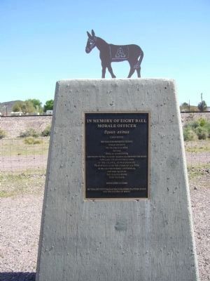
He was our drinking buddy
While on duty
He drank our beer
He was
Full of good cheer
And went to the nurses' quarters around the bend
And came to an untimely end,
Of the Colonel, he was unaware
That it would be the crime of all time . . . — — Map (db m78536) HM
On Ben Hulse Highway (California Route 78) at 1st Street on Ben Hulse Highway.
When Jim Taylor acquired his ferry in 1922, he had just completed his connecting, hand-made highway on both sides of the Colorado River. His plan to attract the Los Angeles to Phoenix traffic had faded with the continued success of the . . . — — Map (db m138179) HM
On State Highway 127, 0.2 miles south of State Highway 190, on the right when traveling south.
This historic crossroad has been used by Indians, Clampers, Death Valley 49ers, ranchers, farmers, settlers and tourists. The town was originally called Amargosa. In 1907, the name was changed to Death Valley Junction. At this junction, the Tonopah . . . — — Map (db m78583) HM
On Red Rock Randsberg Road at Butte Avenue, on the left when traveling north on Red Rock Randsberg Road.
Gold was discovered on the slope of Rand Mountain in 1895. From this discovery, the town of Randsburg sprang up almost overnight. By 1899, the town had over 3500 residents. Randsburg boasted a 100-stamp mill and conservative estimates are that . . . — — Map (db m78578) HM
On U.S. 395 just north of Red Moutain Road, on the left when traveling north. Reported missing.
One of the richest silver strikes occurred in the community of Red Mountain. The Kelly and Grady claims started a silver boom which brought prosperity to this region in the 1900's. In one 60 day period over $170,000 in silver was mined from a hole . . . — — Map (db m158901) HM
On U.S. 395, 0.2 miles south of Red Mountain Road, on the right when traveling south.
The Owl Hotel, where the action was!
Dedicated to Hattie, Little Eva and the girls of the line.
While the men mined silver, they dug for gold. — — Map (db m152430) HM
On Juan Diego Flats Road, on the right when traveling east.
In this valley a conflict between the culture of the Indian and the white man resulted in the death of Juan Diego (Alessandro of the play Romona) by the hands of Sam Temple. — — Map (db m78591) HM
On West Hays Street at North 2nd Street, on the right when traveling west on West Hays Street.
Built in 1915, the Banning Woman's Club Clubhouse is a frame building in the classical revival style with a plain entablature, simple doric columns, and palladian windows, as well as providing a meeting place for the woman's club, the socal and . . . — — Map (db m50710) HM
On 38th Avenue, 1.5 miles east of South Neighbours Boulevard, in the median. Reported missing.
When Jim Taylor acquired his ferry in 1922, he had just completed his connecting, hand-made highway on both sides of the Colorado River. His plan to attract the Los Angeles to Phoenix traffic had faded with the continued success of the . . . — — Map (db m138178) HM
Near Wiley Well Road, 0.1 miles north of Interstate 10.
A.P. Wiley, storekeeper and postmaster at Palo Verde, financed miners to prospect this area early in the1900s. He also financed the first well, approximately 9 miles southerly of here, it was used and maintained for years by prospectors and . . . — — Map (db m50671) HM
On Chiriaco Road, on the right when traveling west.
The Camp Young Airstrip was established at this site in March 1942 by order of General George S. Patton. It was used to provide Camp Young with supplies and other essential material. It supported air transportation for the command staff of the . . . — — Map (db m78550) HM
On Chiriaco Road, on the right when traveling west.
This monument is dedicated to the men and women of the United States Army who were trained here at the Desert Training Center during World War II. — — Map (db m78559) HM
On Chiriaco Road, on the right when traveling east.
Joseph L. Chiriaco came to California from Alabama in 1925. His work as a surveyor for the Los Angeles Bureau of Water and Power and later for the Metropolitan Water District on the Colorado River aqueduct, begun in 1931, brought him to the desert . . . — — Map (db m78543) HM
On Temescal Canyon Road near Interstate 15, on the right when traveling east.
Nearby, an adobe house was built about 1867. It was occupied until 1898 by Leandro Serrano's widow, Josefa. Under Spanish law, she owned the surrounding 20,000-acre Rancho Temescal; but her ownership was denied by the US Supreme Court. — — Map (db m50645) HM
On Rice Road (Route 177) at Coxcomb Monument Road, on the left when traveling south on Rice Road.
The Palen Pass Maneuver Area was the largest training zone within the Desert Training Center/California-Arizona Maneuver Area. Various exercises occurred, including the mock battles of Palen Pass and Southern California, which involved two Divisions . . . — — Map (db m172166) HM WM
On Indio Boulevard east of Smurr Street, on the right when traveling south.
Dr. June Robertson McCarroll was born June 30, 1867 in the Adirondacks and began her medical career in Chicago. She left a promising practice for Indio in 1904. Becoming the sole practicing physician for the entire Coachella Valley. She traveled by . . . — — Map (db m78540) HM
On Pines to Palms Highway (California Route 74) north of Forest Route 6S13, on the right when traveling south.
Lured by the promise of rich gold ore in the nearby Tahquitz Mining District, Harold Kenworthy arrived in Hemet Valley (now Garner Valley) in 1896 to establish the mining town he called Kenworthy. It was a thriving community with a store, hotel, . . . — — Map (db m78527) HM
On Molino Way at Fort Drive, on the right when traveling east on Molino Way.
In 1846 the first grist mill in this region was built nearby by Louis Rubidoux, owner of this section of Rancho Jurupa. The mill provided flour, a popular but scarce commodity, for settlers and American troops. The mill was washed away by a flood in . . . — — Map (db m139100) HM
On National Trails Highway - Historic Route 66 near Old Amboy Road, on the right when traveling west.
Amboy, settled as early as 1858, became a water stop when the Southern Pacific Railroad laid its tracks through the Cadiz Valley in 1883-84. Following the course of the railroad and the National Old Trails Highway, Route 66 was opened in 1926. Amboy . . . — — Map (db m78532) HM
On National Trails Highway at Cadiz Road, on the right when traveling west on National Trails Highway.
Perhaps no other highway in the U.S. is as fabled as old Route 66. It has been immortalized in song, literature, and even a T.V. series as the main street of America. Automobiles came early to the desert, following the railroad with its reliable . . . — — Map (db m78574) HM
On National Trails Highway, on the right when traveling west.
America has always been a nation in motion: west to the Mississippi after the Revolution, west to the Continental Divide Following the Louisiana Purchase, West again to the Pacific Coast after the War with Mexico. Like many of today's railroads, the . . . — — Map (db m241177) HM
During the years 1930 and 1931 the Department of Defense built a network of emergency airfields for use by commercial aviation. During WWII the government converted many of them to military use.
This is the location of Bagdad Auxiliary . . . — — Map (db m241176) HM
On Rasor Road at Crucero Road / Yvonne Boulevard, on the right when traveling east on Rasor Road.
Francis Marion "Borax" Smith built the railroad to move borax out of the hills and Death Valley in 1907 to replace the twenty mule teams that crossed this way to Ludlow. — — Map (db m123898) HM
On Baker Boulevard (Business Interstate 15) east of Caltrans Boulevard, on the right when traveling west.
Marl Springs
Marl Springs was named in 1854 by Army Surveyor Lt. Amiel Whipple for the clay-like soil around the two waterholes. With the establishment of Fort Mojave in 1859, the Mojave (or Old Government) Road came into existence. Marl . . . — — Map (db m159025) HM
On Barstow Road (California Route 247), on the right when traveling south.
The Slash X Ranch was started in 1942 by Lee and Mary Berry. Lee was known as the "Cattle Baron" of the Mojave Desert. At its peak the Slash X ran about 3000 head of cattle. Mary, his wife, did not want drinking and carousing in her house. So using . . . — — Map (db m78519) HM
On Barstow Road (California Route 247), on the left when traveling north.
Previous to the building of Stoddard Wells Road, the primary route of travel between the Fish Ponds (present-day Daggett) and Little Meadows (present-day Victorville) was by way of the Mojave River and Lane's Crossing. Although it later became known . . . — — Map (db m92810) HM
On Holcomb Valley Road (Road 3N16) east of Van Dusen Canyon Road (Road 3N09), on the left when traveling east.
Founded in late 1859. Bellevill was named after Belle Van Dusen, the first child born in Holcomb Valley, she was the daughter of Ted Van Dusen, the town blacksmith and early pioneer. — — Map (db m78590) HM
Near Holcomb Valley Road (Road 3N16) 0.5 miles east of Van Dusen Canyon Road (Road 3N09), on the right when traveling west. Reported missing.
Named for William Francis "Bill" Holcomb, pioneer prospector who, in this valley discovered Southern California's richest gold field - May 5, 1860. — — Map (db m50610) HM
On National Trails Highway (U.S. 66), on the right when traveling east.
From Chicago to Santa Monica Route 66 was dotted with roadside cafes and gas stations. These stops provided a respite for those traveling The Mother Road offering a refreshing soft drink, a burger and fries, or an eye-popping cup of coffee as well . . . — — Map (db m242749) HM
On 2nd Street at King Street, on the right when traveling north on 2nd Street.
This community long served as a supply point and railhead for the mines of Death Valley and Calico. In the early 1880's the first borax produced in Death Valley was hauled by mule team to the Atlantic & Pacific R.R. (later the Santa Fe) at Daggett. . . . — — Map (db m78568) HM
On Santa Fe Street at 4th Street, on the right when traveling east on Santa Fe Street.
The Daggett Garage began life in the 1880s at the borax town of Marion, located on the northeast shore of Calico Dry Lake, as a locomotive repair roundhouse for the narrow-gauge Borate and Daggett Railroad. Daggett blacksmith Seymour Alf used a . . . — — Map (db m78541) HM
On National Trails Highway west of Minneola Road, on the right when traveling west.
Three miles north lies the Mojave River and the site of Forks of the Road. This was the junction of two major travel routes: The Old Spanish or Salt Lake Trail and The Ancient Mojave River Trail. In the 1830s and 1840s the Old Spanish Trail saw . . . — — Map (db m159526) HM
On Aqueduct Road (California Route 62) 0.1 miles west of Parker Dam Road, on the right when traveling east.
Wyatt Earp was born in Illinois March 19, 1848. In 1864 he came west with his family, settling near San Bernardino. He later served as lawman in Wichita and Dodge City, then came to Tombstone in 1879. After the gunfight at the O.K. Corral in 1881, . . . — — Map (db m78569) HM
On Lanfair Road, 0.1 miles north of Goffs Road, on the left when traveling north.
The U. S. Army maintained a camp at Goffs 1942-1944. Goffs was an important railhead, supply point, hospital, and for three months in 1942 Headquarters of the 7th Infantry Division. That unit went on to distinguish itself in combat in the Aleutians . . . — — Map (db m78523) HM
On Lanfair Road, 0.1 miles north of Goffs Road, on the left when traveling north.
The first school in Goffs opened its doors for the fall term in 1911 serving the needs of cattle ranches, mining districts, homesteaders, the railroad, and, most of all, the people supporting expanding travel on the National Old Trails Road – . . . — — Map (db m78575) HM
Near California Route 173, 2 miles east of California Route 138.
[This is a four sided monument with four different markers:]Side A:
Las Flores Ranch
Near this spot on March 25, 1866, Edwin Parrish, Nephi Bemis and Pratt Whiteside, young cowboys employed on this ranch, were ambushed, . . . — — Map (db m166670) HM
On Cajon Boulevard, on the right when traveling east.
Cajon Pass, separating the San Bernardino and San Gabriel ranges, has long been an important natural gateway. It is traversed by Indian trails, emigrant routes, railroads, and a superhighway. Early in the nineteenth century it became the southern . . . — — Map (db m119252) HM
On Arrowhead Villa Road, on the left when traveling north.
Club Arrowhead Villas was constructed and dedicated in 1926 by The Atkins Corporation as seen on the pillared entrance to Arrowhead Villas. It was to be a luxury resort catering to wealthy patrons from across the country seeking adventure and . . . — — Map (db m94403) HM
On Belfield Boulevard at Linn Road, on the right when traveling north on Belfield Boulevard.
The Integratron is the creation of George Van Tassel, and is based on the design of Moses' Tabernacle, the writings of Nikola Tesla, and telepathic directions from extraterrestrials. The domed structure 35 feet high and 55 feet in diameter, was . . . — — Map (db m78533) HM
On Cedar Canyon Road at New York Mountain Road, on the right when traveling east on Cedar Canyon Road.
To the United States Soldiers of Camp Rock Spring --- who guarded the U.S. Mail
No glory there, nor much chance for military fame, but true patriots and heroes were they, to submit to such privations--yet these are the nurseries of the army, . . . — — Map (db m78592) HM
On Lytle Creek Road, on the right when traveling west.
Lytle Creek Canyon in the San Gabriel Mountains has a long and interesting history. It is named for Andrew Lytle, who served as a company commander in the famed Mormon Battalion during the Mexican War. Lytle was among the earliest settlers of the . . . — — Map (db m78514) HM
On Mill Creek Road (California Route 38), on the right when traveling east.
By the mid-nineteenth century the San Bernardino Mountains and Valley were becoming enveloped with civilization. Travelers, merchants, families and explorers were constantly trekking the area, using the old Indian trails and logging roads that had . . . — — Map (db m95645) HM
On Interstate 15, 26 miles south of Primm, on the right when traveling south.
In the late 1860's copper was discovered on Clark Montain and the Clark Mining District was organized. Ore was rich but high transportation costs soon caused mining to cease. In the late 1890's the railroad came within 30 miles and the original . . . — — Map (db m78573) HM
On Harvard Road at Mannix Road, on the right when traveling south on Harvard Road.
The River Bluff Ranch is on the north bank of the Mojave River near the historic locations of Calico Ghost Town, Newberry Springs, Yermo, and abandoned relics of U.S. Army outpost Camp Cady. To the east are the Mojave Road, the Old Spanish Trail, . . . — — Map (db m159411) HM
On National Trails Highway, on the right when traveling west.
The history of Newberry Springs can be traced back more than 20,000 years. Digs at the Early Man Site north of here discovered tools dating prior to 20,000 BC. At that time, much of the land was covered by the prehistoric Lake Manix. Then, around . . . — — Map (db m119927) HM
On Nipton Road east of Nipton Moore Road, on the left when traveling west.
The town of Nipton was born on February 9, 1905 with the coming of the first train on the newly constructed San Pedro, Los Angles and Salt Lake Railroad. Originally called Nippeno Camp after a nearby gold discovery, the name was changed to Nipton . . . — — Map (db m78555) HM
On Manada Road, on the right when traveling north.
For centuries the Cajon Pass has been an important thoroughfare for travelers and traders between the Mojave Desert and Southern California. Following the route of the Old Spanish Trail, most travelers transited the pass on its east side. This . . . — — Map (db m80751) HM
On Mane Street east of Tom Mix Road, on the right when traveling east.
Pioneertown was founded in 1946 by a group of Hollywood personalities led by cowboy actors Dick Curtis and Russell Hayden as a permanent 1880s town for filming western movies. On Sept 1, 1946 Roy Rogers broke ground for the first buildings. Assisted . . . — — Map (db m78539) HM
Near Arrowhead Avenue, on the left when traveling south.
Honoring Pres. Franklin D. Roosevelt who established the Civilian Conservation Corps 1933-1942.
Commemorating CCC enrollees and all who were in the CCC camps in San Bernardino County. — — Map (db m172178) HM
On Trona Road (California Route 178) at Pinnacle Road, on the right when traveling east on Trona Road.
In 1917 a deposit of Epsom salts was discovered near the old Wingate Wash Borax Road at the southern end of Death Valley. In 1919 the claims were acquired by Los Angeles florist Thomas Wright. Although close to an existing road, Wright devised other . . . — — Map (db m78525) HM
On Trona Road (California Route 178) at Pinnacle Road, on the right when traveling east on Trona Road.
This monument commemorates two wagon routes used by the Searles brothers to haul borax from their plant on Borax Lake (now Searles Lake) to the railhead at Mojave. The southern route traveled west of the Trona Pinnacles to Searles' freight station . . . — — Map (db m78554) HM
On Utah Trail at National Park Drive, on the right when traveling south on Utah Trail.
Her tireless efforts to establish Joshua Tree National Monument contributed to a heightened appreciation, not only of the Joshua Tree, but of the total desert environment. — — Map (db m116863) HM
On National Trails Highway, on the right when traveling south.
Emma Jean's Holland Burger Cafe a Route 66 icon has been serving up meals to locals and hungry travelers on the highway since 1947. The building was built by Bob and Kate Holland from cinder blocks manufactured at the old fiber tile plant located . . . — — Map (db m78518) HM
Since ancient times, indigenous peoples have used the many networks of trails in the East Mojave Desert for both seasonal migration and to carry on trade with coastal Indians. Most of these trails converged at narrow passes and safe river crossings. . . . — — Map (db m73550) HM
Warren's Well marks the beginning of the town of Yucca Valley. Mark "Chuck" Warren drove freight wagons through the vally and settled here about 1880. In 1881 he hand-dug the well and later built a windmill, water trough, barn and a small cabin. . . . — — Map (db m78547) HM
A short distance down-stream from this spot, at the head of navigation on the banks of Sonoma Creek, an early landing place was established. From the 1830’s hides and tallow from the Pueblo of Sonoma were shipped to Yerba Buena , and goods and . . . — — Map (db m78551) HM
Near South Casino Drive, on the right when traveling south.
After the United States government's successful experiment with camels in the west in 1857, entrepreneurs saw possibilities in the ungainly beasts for carrying supplies. In addition to the government's camels, which were sold off by 1864, two . . . — — Map (db m78520) HM
On Utah Route 91, on the right when traveling north.
In 1859, after helping settle San Bernardino California, Moses Harris moved his family to Utah and settled on the Virgin River near Quail Creek. In 1862 a flood forced the settlers further up Quail Creek to the Cottonwood Creek Fork. Due to the many . . . — — Map (db m85128) HM
On Kelso Cima Road at Cedar Canyon Road, on the right when traveling south on Kelso Cima Road.
Long ago Mohave Indians used a network of pathways to cross the Mojave Desert to reach the Pacific Coast from their homes along the Colorado River. In 1776, the Spanish Missionary Francisco Garces became the first non-Indian to trek these . . . — — Map (db m78586) HM
On Ave 64E near Interstate 8, on the left when traveling south.
Datelan Army Air Field was established here January 1, 1943. The site was chosen due to the availability of water and the adjacent location of the Yuma Gunnery Range. Construction was completed June 1, 1943. Datelan AAF was a sub-base of Yuma Army . . . — — Map (db m78545) HM
On Trona Wildrose Road at Ballarat Road, on the right when traveling north on Trona Wildrose Road.
Now a ghost town, Ballarat served nearby mining camps from 1897 to 1917. They produced nearly a million in gold. The jail & a few adobe ruins remain. Seldom Seen Slim, it's last resident, was buried in Boothill in 1968. It had a school but no . . . — — Map (db m159350) HM
On Trona Wildrose Road at Ballarat Road, on the right when traveling north on Trona Wildrose Road.
3 1/2 miles east of this point lies Ballarat. Established in 1897 as a mining camp and supply center for the gold and silver mines located on the western slope of the Panamint Mountains. It was named after a well-known gold producing area in . . . — — Map (db m159351) HM
On Pepper Avenue north of Merrill Avenue, on the right when traveling north.
Joe McKamie alerted Fontana Historical Society about Camp. Ora Scott provided interest free loan of $10,000 and City of Fontana gave down payment of $3,000 to save house. Society acquired ownership title to house on November 22, 1978. Restoration . . . — — Map (db m135522) HM
On Broadway Avenue (Arizona Route 72 at milepost 27) south of Main Street, on the right when traveling west.
Camp Bouse
September 1943 to March 1944
"The Kid Battalion"
From Normandy to the Elbe:
•Normandy
•Northern France
•Ardennes
•Rhineland
•Central Europe — — Map (db m78563) HM
On Broadway Avenue (Arizona Route 72 at milepost 27) south of Main Street, on the right when traveling west.
Campaigns
Ardennes, Rhineland and Central Europe
The 739th Tank Battalion was activated in March 1943 at Fort Lewis, Washington. The officers were from various states, the enlisted personnel from Oklahoma, Texas and Louisiana.
The . . . — — Map (db m78558) HM
On Broadway Avenue (Arizona Route 72 at milepost 27) south of Main Street, on the right when traveling west.
The 740th tank battalion was activated at Fort Knox, Ky. on March 1, 1943. It trained at Fort Knox and at Camp Bouse, Az. as a canal defense light (CDL) unit and as a standard medium tank battalion from October 15, 1943 to April 24, 1944 then sailed . . . — — Map (db m78562) HM
On Broadway Avenue south of Main Street, on the right when traveling north.
The 748th Tank Battalion, Medium was activated on 20 August 1942 at Camp Rucker, Alabama. The Rhinos headed for Fort Knox on the 15th of April 1943 for training and on 20 April 1943 were reorganized as a special battalion equipped with CDL . . . — — Map (db m92814) HM
On Broadway Avenue (Arizona Route 72 at milepost 27) south of Main Street, on the right when traveling west.
Camp Bouse was established in Butler Valley 30 miles behind this monument in Sept. of 1943. It was one of twelve such camps built in the southwestern deserts to harden and train United States troops for service on the battlefields of World War II. . . . — — Map (db m78566) HM
On Broadway Avenue (Arizona Route 72 at milepost 27) south of Main Street, on the right when traveling west.
Campaigns
Central Europe Northern France Rhineland
The 701st tank battalion was activated 3/28/43 at Camp Campbell, KY. Here 553 young men and officers began their journey into history. These men began their basic training and for many saw . . . — — Map (db m78564) HM
On Broadway Avenue (Arizona Route 72 at milepost 27) south of Main Street, on the right when traveling west.
Activated 1 April, 1943 at Camp Perry, OH. Completed basic training and then sent to Ft. Knox, KY. Unit then assigned to Camp Bouse, AZ arriving there 9 November, 1943. Maintaining operation of special tanks named "Leaflets" was specific assignment. . . . — — Map (db m78557) HM
On Broadway Avenue (Arizona Route 72 at milepost 27) south of Main Street, on the right when traveling west.
United States Army
World War II
1924 – 2002
Whose dedication to the memory of his brothers in
arms, who fell in the Battle of the Ardennes, made this
historical park possible. — — Map (db m78542) HM
On Broadway Avenue (Arizona Route 72 at milepost 27) south of Main Street, on the right when traveling west.
In honored memory of those soldiers of the battalion who trained here at Camp Bouse and gave their lives in combat to preserve the freedom of the United States and to set the Peoples of Europe free.
Headquarters Company
Donald D. . . . — — Map (db m78537) HM
Near Cibola Road at Baseline Road. Reported missing.
Gold and silver strikes in the 1860's created growth in the area. It is said Wyatt Earp served as sheriff of Cibola for one year in the 1890's. The town of Cibola formed in 1898 and construction began on a 16 mile canal to bring water from the river . . . — — Map (db m78552) HM
Ferries of various size and design once provided transportation across the lower Colorado River linking Arizona with California, Nevada and Utah.
Ferrymen plied their trade from Yuma to Pearce Ferry. The first ferry on the river was started at . . . — — Map (db m78553) HM
On Oatman -Topock Highway / Main Street (Old Route 66 at Rock Hound Road, on the left when traveling north on Oatman -Topock Highway / Main Street (Old Route 66.
Oatman was founded around 1906 as part of Arizona's richest gold mining area. Oatman was reborn in the late 1960's and early 1970's as a tourist town. The main attraction was the wild burro herd. The burros roaming the Oatman area are descendants of . . . — — Map (db m78570) HM
On Ave 64E near Interstate 8, on the left when traveling south.
Camps Hyder & Horn were established 10 miles north of Dateland in the fall of 1943. They were 2 of 15 desert camps built to harden and train United States Troops for service in World War II. The Desert Training Center was a simulated theater of . . . — — Map (db m78546) HM
On California Route 178, on the right when traveling north.
Located at Metbury Spring on the Tonopah and Tidewater Railroad, Shoshone was founded in 1910 by Ralph Jacobus "DAD" Fairbanks. After the collapse of the mining camp of Greenwater (approximately 20 miles northwest of here), "DAD" Fairbanks came to . . . — — Map (db m78511) HM
On Trona Wildrose Road at Ballarat Road, on the right when traveling north on Trona Wildrose Road.
Rich sliver ore was discovered in December 1872 at the head of Surprise Canyon 12 miles northeast of here. The United States Senators for Nevada, John P. Jones and William Morris Stewart, invested in and promoted the camp which drew a peak . . . — — Map (db m159349) HM
On Jawbone Canyon Road at Aerospace Highway (California Highway 14), on the right when traveling north on Jawbone Canyon Road.
"Josie" was born on June 18, 1875 in Silver City, New Mexico to Harvey and Harriet Whitehall. At 19 years old, she taught school in Pinos Altos, New Mexico. She married Herbert Hall Bishop on March 4, 1896, bearing him seven children. The Bishops . . . — — Map (db m78560) HM
On Silverado Canyon Road, on the right when traveling west.
The Santa Ana Mountains, which encompass the canyons of Silverado, Modjeska and Trabuco, provided one of the last refuges for the state symbol, the Grizzly Bear.
At the turn of the century, beekeeping was an important local industry, providing . . . — — Map (db m78516) HM
Near Hobsonway Road, on the left when traveling east.
Blythe Army Air Base was constructed during 1942 to train heavy bomber crews.
127 officers and men recevied orders in February 1943, to form 4 squadrons of the 390th Bombardment Group (H).
The 390th B-17s joined the 8th Air Force in England . . . — — Map (db m78572) HM
On U.S. 95 at milepost 10.5, on the right when traveling north.
On July 17, 1877, Thomas Blythe, a San Francisco financier, filed the first legal claim for Colorado River water rights. Oliver Callaway planned a diversion dam and canal which opened in 1877 to irrigate the Palo Verde Valley. This made possible the . . . — — Map (db m50678) HM
On Midland Road, 10 miles north of Interstate 10, on the right when traveling north.
In May 1964, U.S. Strike Command (STRICOM) launched the largest military war game since World War II. Known as Joint Exercise Desert Strike, this two-week training exercise simulated a nuclear air and ground battle between the mythical governments . . . — — Map (db m78531) HM
On Ragsdale Road east of Eagle Mountain Road, on the right when traveling west. Reported missing.
During the opening days of the World War II, more than 18,000 square miles of the Arizona and California desert were designated by the U.S. Army as a military training facility. The facility, conceived by General George Patton and referred to as the . . . — — Map (db m78512) HM
On Temescal Canyon Road near Interstate 15, on the right when traveling east.
Nearby, two vats were built in 1819 by the Luiseño Indians under the direction of Leandro Serrano, first non-Indian settler in what is now Riverside County. The vats were used in making leather from cow hides. In 1981 the vats were restored and . . . — — Map (db m50643) HM
On Ramona Bowl Road, on the right when traveling east.
Pochea was one of cluster of Indian villages forming the very large settlement of Pahsitna which extended along the ridge east and west of Ramona Bowl. Pahsitnah was thriving when the Spanish first passed by in 1774. A tragic story tells of the . . . — — Map (db m50668) HM
On Iowa Avenue at Spring Street, on the right when traveling south on Iowa Avenue.
The first commercially significant hydroelectric plant in California, designed and built by Gustavus Olivio Newman, went into service here in 1888. Utilizing the flow of the Riverside Water Company Canal to produce about 225 kilowatts of power used . . . — — Map (db m50704) HM
On Big Rock Drive east of Overlook Drive, on the right when traveling east.
The Donaldson Futuro is significant as an example of America's collective
confidence as a leader in space flight, technological advancement, and
economic prosperity. Designed by Finnish architect Matti Suuronen, this space-age
home was the . . . — — Map (db m229843) HM
Near Deglet Noor Street north of Miles Avenue, on the right when traveling south. Reported missing.
This K-8 one room schoolhouse, once known as the Indio Public School, was the second school building to be erected in the area that is now Indio. Originally situated on the Southeast corner of Bliss and Fargo, it was later moved behind the original . . . — — Map (db m78528) HM
Near Miles Avenue at Daglet Noor Street, on the right when traveling west.
In 1926 Smiley Place was built by Dr. Harry W. Smiley. It served as the first medical office in Indio, as well as a residence for he and his wife, Frances. The Smiley's made significant contributions to the social and medical development of the . . . — — Map (db m50728) HM
Once connected to the Gulf of California, waters within the Salton Basin extended nearly to Palm Springs. Because of deposits from the silt laden Colorado River, the north end of the gulf (now in Imperial County) was sealed off and Lake Cahuilla was . . . — — Map (db m78567) HM
On Wineville Avenue at Harrel Street, on the right when traveling south on Wineville Avenue.
The Galleano Winery is the oldest winemaking operation in Riverside County. In 1927 Domenico Galleano pruchased the ranch from Col. Esteban Cantu, Governor of Baja California (1915-1920), including this house which dates from the 1890s. The barn, . . . — — Map (db m50714) HM
139 entries matched your criteria. The first 100 are listed above. The final 39 ⊳
* Inflectional forms of words are their plurals, singulars, and possessives as well as gramatical tenses and similar variations.