Near Paulina Lake Road (NF-21) 0.7 miles east of National Forest Service Road 567 (NF-567).
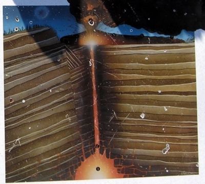
First came a violent eruption of pumice and ash. Then glassy lava oozed from the ground.
(Graphic Index)
1 Magma Chamber
From deep hot regions, liquid rock called magma accumulated in a chamber 2 to 4 miles (3 to 6 km) below the . . . — — Map (db m72436)
On Central Oregon Highway (U.S. 20) near Spencer Wells Road (County Route 23), on the left when traveling east.
Ages ago a river flowed across the high desert country in the rock canyon several hundred yards beyond this marker. The prehistoric river drained a large Ice Age lake that formed from the blocking of normal drainage in the area by lava flows. The . . . — — Map (db m157842) HM
This memorial honors all American Veterans who, although separated by generations, shared a common, undeniable goal – to valiantly protect our country’s freedoms.
The memories of these American Veterans will continue to live on whenever and . . . — — Map (db m279409) WM
Harold and Dorothy Barclay moved to the Sisters Country in 1936 and lived in a one room cabin, south of town near Whychus Creek. They were founders and builders of the Barclay Logging Company, which employed approximately 100 area residents and . . . — — Map (db m279378) HM
On East Main Avenue, on the right when traveling east.
An early settler, stockman, blacksmith and businessman in the Sisters area; Hardy Allen and wife Daisy moved to Sisters in 1905. Hardy’s father, Albert Allen, had arrived in Oregon on the Meek Lost Wagon Train in 1845.
The Allen’s built this . . . — — Map (db m279388) HM
On East Cascade Avenue, on the left when traveling east.
The Gist Hotel stood west of this spot until the fire of 1924 destroyed it, as well as the Hardy Allen Blacksmith Shop at this location and other buildings in town. The fire started while Hattie Gist was back in her garden picking strawberries for . . . — — Map (db m279381) HM
On East Cascade Avenue (U.S. 20) at North Fir Street, on the right when traveling west on East Cascade Avenue.
The hotel was built in 1912 by local businessman and Spanish American War veteran John Dennis. Hot and cold water was available to each of the original 19 guest rooms, and every room was supplied with heat from a hot air furnace located in the . . . — — Map (db m113631) HM
On West Cascade Avenue west of S Elm Street, on the right when traveling east.
On this site was this little cafe which subsequently evolved into the current restaurant. The Ponderosa Café, built in 1934 became Ladd’s Café around 1945. Owner Arthur Ladd was on the Sisters City Council at the time. After his death, new owner . . . — — Map (db m279405) HM
On East Cascade Avenue near South Spruce Street, on the left when traveling west.
Built in 1925 by the Leithausers, an early Sisters family. The structure served as a general store until 1950, when a new store was built two lots to the West. Over the years, the building has been used as a barber shop, variety store, yarn mill and . . . — — Map (db m158083) HM
On East Cascade Avenue at S Fir Street, on the right when traveling east on East Cascade Avenue.
In 1950, the Leithauser family built this building as a new modern supermarket to expand their grocery business from the small building two lots east. As the town grew, they added a variety store and barbershop. Hours were long, particularly during . . . — — Map (db m279400) HM
On N Spruce Street, on the right when traveling south.
The original site of the library was on Cascade Street. Money to purchase the land was raised by area residents and businesses and construction material was donated by local mills. The library officially opened in 1939. The 14' x 20' structure has . . . — — Map (db m279384) HM
On East Cascade Avenue at N Elm Street, on the left when traveling east on East Cascade Avenue.
On this site was the old Owl Tavern, a favorite watering hole in old Sisters. If the walls could talk, there would be stories of pranks, the confiscation of the brand new slot machine, gunshots, horses and even a camel being ridden through the doors . . . — — Map (db m279403) HM
On West Cascade Avenue, on the right when traveling west.
On this site in 1895, the Robert Smith General Store was a substantial building owned by brothers Alex and Robert Smith, who also platted the town in 1901. The second floor was used for dances and Odd Fellows Lodge Meetings. The store catered to . . . — — Map (db m279376) HM
On East Main Avenue, on the left when traveling east.
This was the first church built in Sisters in 1914. Although designated as Presbyterian, it was more of a non-demoninational community effort. John and Myrtle Dennis donated the land, Perit Huntington hauled in the foundation rocks, Joe Duckett . . . — — Map (db m279387) HM
On East Cascade Avenue, on the left when traveling west.
On this site was Sorenson’s Auto Court and the first service station in Sisters. It was built about 1924 when more automobiles were coming through town. Chris Sorenson kept adding motel units with attached carports in a U-shape around the Shell . . . — — Map (db m279399) HM
Near McKenzie Highway (Oregon Route 126) 1.6 miles south of U.S. 20, on the right when traveling south.
You are standing on the shore of a lake that may seem old but in geologic terms was formed yesterday. Fish Lake continues to change, seasonally and through the decades.
Around three thousand years ago an eruption of Nash Crater formed Fish Lake . . . — — Map (db m70950)
On East Cascade Avenue (U.S. 20) at South Elm Street, on the left when traveling west on East Cascade Avenue.
The original structure on this site was owned by the Aitken family and called the Sisters Drug Store. It also housed the town post office. The upstairs was used by the Forest Service to store records. It was destroyed by the fire of 1923. Shortly . . . — — Map (db m158082) HM
Near McKenzie Highway (Oregon Route 126) 1.6 miles south of U.S. 20, on the right when traveling south.
Welcome to historic Fish Lake.
Now a quiet and peaceful place, it was once filled with the hustle and bustle of people working and traveling across the Cascades.
Nearby is the Fish Lake Remount Depot which has been in continuous use as a . . . — — Map (db m62025) HM
On Great Hall Loop, on the right when traveling east.
In November 1942 the cattle contentedly grazing on what is now Sunriver’s great meadow found themselves suddenly replaced by dozens of energetic construction workers. Laboring through what was called “the worst winter since 1919,” they completed a . . . — — Map (db m231867) HM WM
Near Blue Star Memorial/Dalles to California Highway (U.S. 97 at milepost 113), 1.2 miles north of Wimp Way, on the left when traveling north.
Peter Skene Ogden was born at Quebec in 1794. He explored Central Oregon for the Hudson's Bay Company in 1825 and in December of that year discovered Crooked River not far from this spot. He died at Oregon City in 1854.
Land for this park was . . . — — Map (db m80487) HM
On Southwest 5th Street at South East Canyon Street, on the right when traveling east on Southwest 5th Street.
(Seven panels dealing with topics related to the Applegate Trail are found at this kiosk.)
Applegate Trail
Southern Route to Oregon
In 1846, Jesse Applegate and fourteen others from near Dallas, Oregon, established . . . — — Map (db m112862) HM
This portion of the southwest Oregon is homeland to the Cow Creek Band of Umpqua Indians. They thrived here for thousands of years before contact with Euro-Americans. Living in plank-house villages, they followed a seasonal round of resource use. . . . — — Map (db m112859) HM
On Northwest Pine Street at SW 2nd Street, on the left when traveling north on Northwest Pine Street.
Prior to the dedication of the United Methodist
Church in Canyonville, the Methodist
congregation, under the first pastorship of
Reverend George H. Brown (1857-58), met in the
town's schoohouse. Two building lots were
donated to the . . . — — Map (db m303543) HM
[Marker one] The Chinook word "Toketee" means "pretty", which aptly describes this waterfall's graceful form and picturesque setting. Chinook Jargon was a language developed by Northwest Native Americans to enable communication while trading . . . — — Map (db m285760) HM
John Dellenback Trail
In Honor of
John Richard Dellenback
United States Representative from Oregon (1967-1975),
Champion of Outdoor Recreation
USDA Forest Service
Umpqua National Forest
Diamond Lake Ranger . . . — — Map (db m306078) HM
On Elkton-Sutherlin Highway (Oregon Route 138) south of Mehl Creek Road, on the right when traveling south.
On the west bank and upstream is the site of Fort Umpqua.
Established in 1836 by the Hudson’s Bay Company, the fort was a twelve foot high and ninety foot square stockade with bastions at diagonal corners.
The fort served as a dwelling for . . . — — Map (db m113337) HM
On Oregon Coast Highway (U.S. 101) at Jewett Lane, on the right when traveling south on Oregon Coast Highway.
On October 1, 1850, the schooner "Bostonian” owned by a Boston merchant named Gardiner was sent to the Pacific coast in the interest of trade. The ship wrecked on the Umpqua River bar. Most of her cargo was salvaged and brought to this site, known . . . — — Map (db m176983) HM
After construction of a railroad line South from Roseburg in 1881-1883, Solomon Abraham, the local right of way agent, platted the community and named it Julia after his wife. After a dispute with Abraham, A.F. Morris, the Chief Engineer for the . . . — — Map (db m134058) HM
Near Volunteer Way near SW 2nd Avenue, on the right when traveling east.
Used in the grist mill built in 1853-54 by Lazarus Wright. The mill was located next to the planked bridge crossing in the 'village' of Myrtle Creek near the current location of the Dairy Queen. The mill was managed by John Hall, the founder of . . . — — Map (db m114456) HM
On NE 1st Street at SE Maple Street, on the left when traveling north on NE 1st Street.
In 1846, Jesse Applegate and fourteen others from near Dallas, Oregon, established a trail south from the Willamette Valley and east to Fort Hall. This route offered emigrants an alternative to the perilous “last leg” of the Oregon Trail . . . — — Map (db m116842) HM
On 1st Street at Locust Street, on the left when traveling north on 1st Street.
Established in 1851 by Dr. Dorsey S. Baker. The town moved to the present site in 1872 when the O&C Railroad reached this point. Alonzo F. Brown founded the new town. Fires destroyed the wooden buildings. The existing brick buildings were built in . . . — — Map (db m99321) HM
On Interstate 5, on the right when traveling south.
The story of the Cow Creek Band of Umpqua Tribe of Indians is a tale of perseverance and strong recovery in the face of great loss. Epidemics and hostilities with miners let to large population declines. The tribe entered into a treaty with the . . . — — Map (db m99222) HM
On Old Highway 99 North north of North Old Town Road, on the right when traveling north.
Dedicated to the memory of
Rev. J.A. Cornwall and Family
They built the
First Immigrant Cabin
in Douglas County near
this site hence the name
Cabin Creek
The family wintered here in
1846 1847
Were saved from extreme want
by . . . — — Map (db m99269) HM
On SE 2nd Street at SE Maple Street on SE 2nd Street.
Taken from a grist mill built in old town of Oakland by Dr. Dorsey S. Baker in 1851.
It turned the grinding stone that ground the grain to meal and flour. Shipped by boat around Cape Horn in the older days. — — Map (db m116841) HM
On Umpqua Highway (Oregon Route 38) 4 miles west of Loon Lake Road, on the right when traveling west.
On August 8th, 1850, the schooner Samuel Roberts grounded on this bar during her maiden voyage to Scottsburg as part of the Klamath exploring expedition.
She was the first recorded American Vessel to navigate the Umpqua River.
While waiting . . . — — Map (db m113339) HM
On Water Avenue at North 3rd Street, on the left when traveling east on Water Avenue.
A Big Piece of Reedsport History
Here, restored by citizens of Reedsport, is one of the largest steam donkeys to work the Oregon woods, the Smith and Watson 12 X 13 compound geared universal yarder. It was placed in service in 1915 . . . — — Map (db m113331) HM
On Oregon Coast Highway (U.S. 101) 0.1 miles south of Lower Smith River Road, on the right when traveling south.
Jedediah Smith's explorations in the American West began when he was 21 and lasted until his death at age 32. He crisscrossed the region in search of beaver pelts and new travel routes. His travel journals became a foundation for the first . . . — — Map (db m176970) HM
On Oregon Coast Highway (U.S. 101) 0.1 miles south of Lower Smith River Road, on the right when traveling south. Reported missing.
Jedediah Smith, making the first recorded overland trip from California,
followed the Oregon coast northward
and on July 13, 1828 camped with seventeen trappers on the north bank of
Smith River channel five-eights
of a
mile northeast of this . . . — — Map (db m237385) HM
On Lighthouse Road west of Oregon Coast Highway (U.S. 101), on the right when traveling north.
This former U.S. Coast Guard facility built in 1939, was restored by the Douglas County Park Department and dedicated as a public recreation facility on June 19, 1980.
Douglas County Board of Commissioners
Bill Vian, Chairman
. . . — — Map (db m113507) HM
On Lighthouse Road west of Oregon Coast Highway (U.S. 101), on the right when traveling north.
Originally the first lighthouse in the Oregon Territory. Was built in 1857 near the mouth of the river.
It was undermined and destroyed by flood in Feb. 1864.
Rebuilt here in 1891 and completed in 1894.
It shines a guiding light to all . . . — — Map (db m113915) HM
On Walter Avenue at North 3rd Street, on the left when traveling east on Walter Avenue.
Oxen Replaced Mules And Donkeys –
Steam Donkeys Replaced Oxen
By the early 1900’s steam yarders or steam donkeys, as they came to be known, industrialized logging.
These large steel and cast iron steam machines . . . — — Map (db m113474) HM
On Lower Smith River Road (County Road 48 at milepost 1), at Stables Road (County Road 498), on the left when traveling north on Lower Smith River Road.
Smith, Jackson & Sublette Beaver Trappers
-- In Memory of --
Thomas Daws · John Gaither · John Hanna · Abraham Laplant · Joseph Lapoint · Emmanuel Lazarus · Toussaint Marechal · Martin McCoy · Joseph Palmer · Peter Ranne · . . . — — Map (db m237193) HM
This tree was given to Douglas County by Binger Hermann, U.S. Congressman, around the turn of the century. The occasion for the tree donation is not known positively, but research suggests that it was given at a dedication ceremony for the . . . — — Map (db m112587) HM
On SE Douglas Ave, on the left when traveling east.
This memorial is dedicated to all Douglas County Men and Women who have served their country in its several armed conflicts and especially to those who make the supreme sacrifice, many of whom are listed here.
Re-dedicated July 4, 2010 — — Map (db m113265) WM
On Vineyard Lane at Elgarose Road, on the left when traveling south on Vineyard Lane.
Oregon’s successful and widely recognized wine industry can be traced to this place, where Richard Sommer first planted Pinot noir grapes in 1961. The Umpqua and Willamette valleys’ climates and topographies are much like those of European wine . . . — — Map (db m315869) HM
This is the site of the explosion which occurred in the early hours of August 7, 1959, resulting in fourteen deaths and injuring fifty seven persons. A fire in a lumber yard detonated a truck loaded with explosives and caused property losses . . . — — Map (db m112863) HM
On SE Lane Ave at SE Jackson St, on the right when traveling south on SE Lane Ave.
The original Hebe Fountain was a joint project of the 1895 Mental Culture Club (now known as the Roseburg Woman's Club) and the Women's Christian Temperance Union. Providing water for horses, dogs, and humans, the fountain stood in the intersection . . . — — Map (db m112848) HM
On SE Pine Street south of SE Woodward Avenue, on the left when traveling south.
Placed on the National Register of Historic Places 1985
The Mill-Pine neighborhood grew out of a need for housing close to the railroad. The Oregon-California railroad line was completed from Portland to Roseburg in 1872 and on to Ashland in . . . — — Map (db m99323) HM
On Southeast Spruce Street at SE Washington Ave (U.S. 138) on Southeast Spruce Street.
Southern Oregon is a land of great geographic diversity. Here are the more than 250-million-year-old Klamath Mountains in the south, and to the north and uplifted 50-million-year-old ocean floor and overlying sediments, called “Siletzia” . . . — — Map (db m112535) HM
On Umpqua Highway (Oregon Route 38) at Main Street, on the left when traveling west on Umpqua Highway.
Few Oregon communities have had a more colorful history than Scottsburg. It was named for Levi Scott, a pioneer of 1844, who homesteaded here and founded the town in 1850. There was a lower town at the head of tidewater on the Umpqua River which . . . — — Map (db m113510) HM
Near Tiller Trail Highway (Oregon Route 227) at Avery Berry Loop (Forest Road 1600), on the right when traveling north.
In 1921 the Forest Service began, using a lookout tree on the Red Mountain in the upper Cow Creek Valley to detect fires in the surrounding mountains and valleys.
The tree was replaced by a cupola style lookout in 1928. This building was moved . . . — — Map (db m113334) HM
Near Tiller Trail Highway (Oregon Route 227) at Avery Berry Loop (Forest Road 1600) when traveling north.
These buildings, constructed by the Civilian Conservation Corps (CCC) during the period between 1933 – 1942, are excellent examples of the Depression-era, rustic style of U.S. Forest Service structures.
The building in the upper left . . . — — Map (db m113336) HM
On Beech Street at Locust Street, on the right when traveling west on Beech Street.
(Seven panels dealing with the Columbia Plateau and Columbia River portions of the Oregon Trail are found at this kiosk)
Pathway to the "Garden of the World"
Excitement filled the air May 22, 1843 as nearly one thousand Americans left . . . — — Map (db m111946) HM
On Oregon Route 19 0.4 miles south of Montague Lane, on the right when traveling south.
Who followed this route across the plains at the age of 17 driving oxen and walking barefoot.
He later settled on Shuttler Flat five miles south of this marker and was the first to engage in wheat farming in Gilliam County — — Map (db m101983) HM
On Up Middle Fork Road (County Highway 20), on the right when traveling west.
There are five markers describing the areaMarker 1:
A history of human interaction with the land
From tribal use to ranching, gold mining, and ecological restoration, the land that is now the Oxbow Conservation Area . . . — — Map (db m107488) HM
On Boot Hill Road, on the left when traveling west.
There are four graves, that of two women and two men. We do not have records of their time of passing, their names, or their individual location within this enclosure, but assume it to be during the gold rush days of 1862-1880. We also do not know . . . — — Map (db m107538) HM
On Park Street at Highway 395, on the right when traveling east on Park Street.
Gold was discovered on Whiskey Flat in June, 1862; Canyon City quickly grew and became the County Seat by 1864. Scenes and Characters from the early years come alive in this 1996 mural by Larry Kangas.
This colorful history is celebrated at "62 . . . — — Map (db m96719) HM
On South Washington Street at Park Street, on the left when traveling south on South Washington Street.
In June 1862, a company of miners from northern California were heading east over the Strawberry Mountain Range, when one of the men discovered gold on Whiskey Flat, half a mile south of here. Miners from all over the area flocked into the area, and . . . — — Map (db m96722) HM
Near John Day Highway (Oregon Route 19) 2 miles north of U.S. 26, on the left when traveling north.
“What is it that urges a man to risk his life in these precipitous fossil beds? I can answer only for myself, but with me there were two motives, the desire to add to human knowledge, which has been a great motive all my life, and the . . . — — Map (db m114115) HM
This haystack was built on-site from mail order hardware and locally-milled lumber. A hay buck was used to push hay onto the fork. Horses pulling a cable attached to the fork life the load. Tripping a lever near the base released the hay. — — Map (db m158014) HM
On State Highway 19 near U.S. 26, on the right when traveling north.
James and Elizabeth Cant purchased this property in 1910. Over the following five decades they built the ranch before you. The methods used by the Cants in their early operations were replaced with more modern machinery and techniques as they . . . — — Map (db m158007) HM
Near State Highway 19 near U.S. 26, on the right when traveling north.
The Cant Ranch is one of the best-preserved examples of early 20th century ranching operations in the John Day River Valley. The ranch spans three historic development eras: The Officer Homestead Era (1890-1909); the Cant Sheep Ranch Era . . . — — Map (db m158010) HM
Near State Highway 19 near U.S. 26, on the right when traveling north.
Water, the lifeblood of any working ranch, flows in irrigation ditches fed by rivers, creeks, or a steady spring or two. In this dry landscape, these human-made arteries, like the one before you, have made the rich soils of the flood plain . . . — — Map (db m158011) HM
Marker 1 Shows an overview map of the National Monument with other points of interest.
Marker 2 Like Icing on a Cake. "Between 16.6 million and 15 million years ago, eastern Oregon sat above the nascent Yellowstone hot spot's . . . — — Map (db m108677) HM
Near State Highway 19 near U.S. 26, on the left when traveling north.
The Cant family's touring car might have traveled this trail route frequently. Before highway improvements were made in the 1930s, the trail on which you are standing is a remnant of the historic fabric that makes up this spot, a clue to the way its . . . — — Map (db m158008) HM
On Oregon Route 19 0.2 miles north of U.S. 26, on the left when traveling north.
The dark layers of Picture Gorge were formed from seventeen distinct floods of lava flowing from nearby cracks in the earth. These basalt flows joined with others covering much of eastern Washington and Oregon, and northern Idaho, beginning about 16 . . . — — Map (db m71521)
For most of the year, this platform sat empty and quiet. For two or three weeks in the spring, however, this small space bustled with bawling sheep, sweaty workmen, and grinding machinery.
Each of the ten workstations was supplied with . . . — — Map (db m158070) HM
Near Oregon Route 19 near U.S. 26, on the right when traveling north.
After the sheep were sheared, they went to pasture for the summer, typically a grazing allotment on one of the national forests. Herders trailed the sheep to and from the allotment on foot with the help of skilled dogs, a trip that could take as . . . — — Map (db m158067) HM
Near Oregon Route 19 near U.S. 25, on the right when traveling north.
You are standing in the middle of a lively watershed. Supporting a diverse community of aquatic and terrestrial life, the John Day River is the longest free-flowing river west of the Rocky Mountains, flowing over 280 miles to its mouth at the . . . — — Map (db m158071) HM
Near Oregon Route 19 near U.S. 26, on the right when traveling north.
Wool bag stand and bag from the Trosper Ranch near Antone, OR, about 1900.
At shearing time each spring, wool freshly sheared was packed in burlap bags for shipment. The cut wool was tossed into the bag. A person, usually a youth, was inside the . . . — — Map (db m158068) HM
On West Center Street at Forest Road 73, on the right when traveling east on West Center Street.
Side A:
Granite, Oregon
Albert G. Tabor first struck gold just below the town of Granite on the Fourth of July, 1862. Tabor named his claim the Independence since his strike was made on Independence Day, and the town that sprang up . . . — — Map (db m106791) HM
On Bremner Pass Road near West Main Street ( Route 26), on the right when traveling west.
The CCC was created in 1933 to provide young men useful work during the Depression. Camp Canyon Creek (Company 1231) was established in 1937. The CCC built numerous facilities such as District offices, the John Day Compound, fire guard stations, . . . — — Map (db m107548) HM
On Northwest Bridge Street just north of West Main Street (U.S. 26), on the right when traveling north.
The mining camp town of Canyon City sprang up soon after the discovery of gold in Canyon Creek in 1861 (Note: actually June of 1862).
When Grant County was formed in 1864 Canyon City became the county seat. Meanwhile, "Lower Town" . . . — — Map (db m107547) HM
Near Ing-Hay Way north of NW Canton Street, on the left when traveling north.
Has Been Designated a
National Historic Landmark
This property possesses national significance
in commemorating the history of the
United States of America
Kam Wah Chung Company Building is the best and earliest known . . . — — Map (db m112884) HM
On West Main Street (U.S. 26) east of NW Bridge Street, on the left when traveling east.
This church was built in the late 1890s by an Advent Christian minister. Dedicated in 1900, it was used for worship until the 1930s.
After this congregation disbanded, the church was vacant for several years. During the early 1940s the . . . — — Map (db m114109) HM
On U.S. 26 at Bridge Street, on the right when traveling west on U.S. 26.
Upper Marker:
This church was built in the late 1890s by an Advent Christian minister. Dedicated in 1900 it was used for worship until the 1930s. After this congregation disbanded, the church was vacant for several years. During the . . . — — Map (db m107546) HM
Welcome to Kam Wah Chung
In 1890 you would be standing in the middle of a bustling Chinatown.Businesses and homes all around you, the temple in front, and Kam Wah Chung- the core of the community- would be to your left. Why is it the only . . . — — Map (db m112887) HM
Elevation 5000 feet Surface 50 acres
Depth 98 feet.
Magone Lake was formed in the early 1800s by a landslide which dammed Lake Creek. Notice the tilted trees which rode down with the slide.
The lake was named for "Major" Magone and . . . — — Map (db m107489) HM
Near South Main Street, on the left when traveling south.
As better roads were built into the area, the need for the railroad diminished. The last run was made in 1947. The rails were removed and equipment was sold or scrapped. Some portions were widened and became roads, while the rest was gradually . . . — — Map (db m284120) HM
On John Day Highway (U.S. 26), on the right when traveling east.
Imagine the American Indians first creating trails through these mountains hundreds of years ago. Later, in 1825 and 1826, Hudson Bay Fur Company trappers, led by Peter Skeene Ogden, crossed this very pass. In 1862 more people made this difficult . . . — — Map (db m107101) HM
Near South Main Street, on the left when traveling south.
To conquer the rugged mountains and canyons, builders of the Sumpter Valley Railway resorted to a number of special engineering techniques. Steep grades of up to 4%, twice as steep as normally used on railroads, were numerous. Deep cuts were . . . — — Map (db m284122) HM
On 4th Street at Barnes Street (U.S. 395), on the left when traveling west on 4th Street.
For the longest time life here in Bear Valley as quiet and change was slow.
Native American seasonal camps gave way to small ranching operations of the first Europeans. In good weather the stagecoach ran through the valley. And in 1895, . . . — — Map (db m108734) HM
On Barnes Avenue (U.S. 395), on the right when traveling south.
After spending a day skidding logs, laying track or building Seneca's first homes, the workers needed a place to call home; temporarily at least.
In 1928 "Camp One" was established southwest of here, and with boxcars for homes, . . . — — Map (db m108735) HM
Back in the early 1920's you may have left the dirt streets and wooden sidewalks of the town of Burns, to walk in these woods, where untouched ponderosa stood tall.
But in a few short years, one of the biggest ever timber sales in the . . . — — Map (db m108836) HM
When the railroad was being built the forest here was a busy place with trees being felled to make ties, and rock being blasted for ballast. In February 1927, forest ranger G. C. Blake reported:
"Yesterday I made the trip from . . . — — Map (db m108872) HM
Fort Harney, on the former Malheur Indian Reservation, was named for Gen. Wm. S. Harney, who took command of the Military Department of Oregon, Sept. 13, 1858. The fort was established Aug. 10, 1867, and became a permanent Military Post. By order of . . . — — Map (db m63026) HM
On N Foley Drive at Alder Avenue, on the right when traveling north on N Foley Drive.
Pioneer Cattleman and Artisan in Wrought Iron
Designer of Harney County's Early Cattle Brands
Organized Two Pioneer Cooperatives
Sponsored Lumber Milling as Our Second Industry
Harney County's First Water Master
Resident 1883 – . . . — — Map (db m305058) HM
On U.S. 20 at South Harney Road, on the right when traveling east on U.S. 20.
Weary Oregon Trail emigrants, eager to ease travel or gain mileage, often attempted cutoffs and shortcuts. While many of these alternate routes proved successful, others did not--they became roads to ruin for some and the end of the trail for . . . — — Map (db m63032) HM
On February 9, 1945 at approximately 10 PM this aircraft, a Consolidated B-24D, serial number 42-40427,
crashed at this location in the Pueblo Mountains. The plane was on a "round robin" navigation training
mission from Gowen Field near Boise, . . . — — Map (db m275414) HM
Migrating fish are attracted to large flows of water coming from the Bonneville Dam. To take advantage of this natural reaction, fish-collection facilities are placed along the face of the powerhouse and at each end of the spillway dam. These . . . — — Map (db m92686) HM
Near Southwest Cascade Avenue near Wa Na Pa Street.
Thousands of Oregon Trail emigrant passed this way toward new lives in a place Abigail Scot, emigrant of 1852, called the "Garden of the World" The Willamette Valley was nearly 2,000 miles from Missouri, and by the time emigrants reached this . . . — — Map (db m158539) HM
Construction of the Columbia River Highway begun here in 1912
Funds were contributed by Simon Benson Labor was performed by honor men detailed by Governor Oswald West — — Map (db m292156) HM
Sturgeon range throughout the Columbia River system, however the construction of Bonneville Dam and the other dams upstream blocked sturgeon migration. Sturgeon, unlike salmon, do not use fish ladders. Sturgeon below Bonneville Dam travel up and . . . — — Map (db m92687) HM
On Wa Pa Na Street, on the right when traveling south.
Although steel has been made for centuries, it wasn’t until the Bessemer process was introduced in the 1870s that it could be produced in quantity.
The Bridge of the Gods mural is the creation of Larry Kangas, of Beaverton, . . . — — Map (db m112267) HM
"The first locomotive ever run over the first railroad ever built in the state of Oregon"
Early travel on the Oregon Trail was extremely dangerous. The last 100 miles of the journey westward from The Dalles to the Willamette . . . — — Map (db m158538) HM
Near East Port Marina Drive north of Interstate 84 when traveling north.
High in the tower, the school bell rang, resonating across the grounds.
Sixteen school kids grabbed their lunch pails and headed with their teacher, Miss Graham, into the 1893 Crapper School.
As the community grew, the students outnumbered . . . — — Map (db m113941) HM
On Oak Street (U.S. 30), on the left when traveling west.
Leslie and Truman Butler commissioned well-known Portland architect A.E. Doyle to design a bank of the Butler Banking Company, the business they founded in 1900. The Egyptian style building was completed in September 1924, and the grand opening . . . — — Map (db m112295) HM
On Oak Street (U.S. 30) near 2nd Street, on the left when traveling west.
Harry DeWitt built this new automobile garage in 1920 when the demand for new cars and service was high in Hood River. During the Great Depression of the 1930s, the garage was divided and used as the Greyhound Bus Station, a service garage, and a . . . — — Map (db m112235) HM
1437 entries matched your criteria. Entries 401 through 500 are listed above. ⊲ Previous 100 — Next 100 ⊳