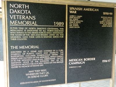
North Dakota Veterans Memorial 1989 In this year of North Dakots's centennial, this monument is dedicated to all North Dakotans who served in the armed forces since statehood.The names of the men and women listed on this memorial gave their . . . — — Map (db m44701) WM
The first scholarly archaeological study of a Mandan earthlodge village village site was made in 1905 by Harvard University students George Will and Herbert Spinden. They excavated portions of six midden mounds, two houses, six cache pits, and the . . . — — Map (db m154677) HM
This was the site of one of the largest river warehouses built during the 1870s when river transportation was of primary importance. The warehouse was served by a spur track of the Northern Pacific Railway and until the railroad was built west of . . . — — Map (db m154055) HM
Presented by the French National Railroads
to the State of
North Dakota
in gratitude for the help given to France
by the American people — — Map (db m44706) HM
Bullboats, round-bottomed watercrafts, were used by the Mandans, Hidatsas, and Arikaras to transport goods and people
along waterways. Bullboats were indispensable for river traffic and for hauling loads of driftwood for cooking and heating
fires. . . . — — Map (db m164368) HM
In honor of United States military personnel and veterans from Burleigh County for their service to our great Nation Dedication Date August 18th, 2022 Duty Honor Country — — Map (db m235002) WM
The State Historical Society of North Dakota acquired Camp Hancock in 1951 for preservation as a state historic site. Work began to repair fire damage on the lone remaining structure, the officers quarters from the 1870s, used later as the U.S. . . . — — Map (db m154548) HM
When plans for the Church of the Bread of Life were accepted in August, 1879, the Episcopal congregation's building committee contracted to spend $2,500 to build a place of worship. The funds, raised by benefit suppers and entertainments, proved . . . — — Map (db m154545) HM
Dedicated to all men and women wounded in all our wars.My stone is red for the blood they shed. The medal I bear is my country's way to show they care if I could be seen by all mankind maybe peace will come in my lifetime. — — Map (db m44704) HM
Fortification systems attest to the fierce warfare between villagers and surrounding nomadic tribes that is reported in early historic records. Ditch 2 that you seen in front of you at Double Ditch appears to have combined mounds and the ditch, with . . . — — Map (db m154250) HM
Ditch 3 is more recent than Ditch 4 and was constructed in the AD 1500s. Ditch 3, with only a few bastions, encompasses 15 acres and, like Ditch 4, is not visible on the surface. It reflects a fallback to a slightly smaller community and simpler . . . — — Map (db m154708) HM
Double Ditch Indian Village, overlooking the Missouri River, was a large earthlodge village inhabited by Mandan Indians between AD 1490 and 1785. The remains of earthlodges, midden mounds (trash heaps), and two fortification ditches are clearly . . . — — Map (db m154709) HM
Double Ditch Indian Village, overlooking the Missouri River, was a large earthlodge village inhabited by Mandan Indians between AD 1490 and 1785. The remains of earthlodges, midden mounds (trash heaps), and two fortification ditches are clearly . . . — — Map (db m154710) HM
The first non-Roman church service to be held in what is now Bismarck was the baptism of a son of Lt. Humbert of Camp Hancock by the Rev. J. Smith, and Episcopalian missionary This marked the beginning of Episcopalian services in the . . . — — Map (db m154650) HM
In front of you is a segment of the inner fortification ditch. Mandan villages usually were surrounded
by a ditch and wood palisade to keep out enemies. These villages also used natural features, such as
steep terrain and riverbanks, for added . . . — — Map (db m164478) HM
On this spot, July 31, 1863, occurred the first Masonic ceremony held in the present state of North Dakota. It was the Masonic funeral of Lieutenant Fred J. Holt Beaver, an Englishman and Oxonian, and a volunteer soldier, attached to the staff of . . . — — Map (db m234899) HM
From approximately this spot on July 5, 1876, Colonel Clement A. Lounsberry, the founder of the Bismarck Tribune in a feat of newspaper enterprise that overcame many obstacles, flashed - - by telegraph - - to the New York Herald the first account of . . . — — Map (db m85829) HM
Geophysics applies the methods of physics to remotely investigate and define objects or materials
in the earth's subsurface without direct contact. Geophysical investigations do not disturb the
soil and cultural features, as do traditional . . . — — Map (db m164367) HM
Glaciers altered river courses and molded the North Dakota landscape, creating the gently rolling, hilly terrain seen in most areas of the state today. Prior to about three million years ago, all the rivers in today's North Dakota flowed toward . . . — — Map (db m164376)
Camp Hancock was the location of an infantry post from 1872 to 1877 and a quartermaster depot and signal office until 1894. The post was originally named Camp Greeley in honor of Horace Greeley, an editor of the New York Times and candidate . . . — — Map (db m154971) HM
The Mandans, as well as the Hidatsa and the Arikaras, built dome-shaped houses of logs and earth, known as earthlodges. All that remains of the earthlodges on the surface are circular depressions. The men usually decided how large an earthlodge . . . — — Map (db m154544) HM
While the Mandans relied heavily on the cultivation of plants, they
were also skilled hunters. Bison hunting was as important as farming
and bison were vital to the Mandan diet. Before the arrival of horses,
bison were stalked individually, or . . . — — Map (db m164358) HM
By the time Lewis and Clark began their epic journey, the Ward Indian Village site (renamed Chief Looking's Village in 2003) had been abandoned. The Mandan and Hidatsa were displaced north, reduced in number by smallpox and warfare. The journals . . . — — Map (db m270046) HM
Going Upriver:
21st October Sunday 1804 (William Clark):
“…passed just by above our Camp a Small river on the L.S. Called by the Indians Chiss-Cho-tar (the Heart River) — this river is about 38 yards wide Containing a good Deel of water— . . . — — Map (db m269935) HM
This coal-fired steam locomotive was built by the Baldwin Locomotive works of Philadelphia, Pennsylvania for the Northern Pacific Railway in 1909. Numbered 2164 by the Northern Pacific, the locomotive and coal tender weigh 298,600 pounds, are 78 . . . — — Map (db m154970) HM
Mandan origins and history have been passed on orally. These origin stories are memorized and passed from generation to generation, telling the history of a
people. These traditions provide information regarding the origins of sacred bundles and . . . — — Map (db m164357) HM
Life for these agriculturalists centered on the cultivation and trade of native corn, beans, squash, and sunflowers along with hunting. Women watched the skies
carefully for the arrival of flocks of geese and ducks, which signified the arrival of . . . — — Map (db m164355) HM
The raised areas you see around the village are midden mounds or earthen mounds ranging from one to ten feet high. There are more than 30 mounds surrounding the village. The Mandans at Double Ditch disposed of their trash in heaps such as the one in . . . — — Map (db m154930) HM
Missouri River The Missouri River valley provided water, food, and shelter for the Mandans. Abundant timber and game could be found in the wooded bottomlands, and bison flourished on the surrounding prairie grasslands. The terrace edge . . . — — Map (db m154068) HM
Pó is the root for fish in the Mandan language-pótande is the catfish. The Missouri River system, along with its larger
tributaries such as the Heart River, supported fisheries that the Mandans drew upon as part of their subsistence . . . — — Map (db m164371) HM
Sakakawea Sakakawea has become a recognized name as part of the Lewis and Clark expedition. Although her name is famous, few facts remain to document her life and contributions to the voyage. When Lewis and Clark met Sakakawea in 1804 she was . . . — — Map (db m43838) HM
Square Buttes is a prominent and imposing landmark along this stretch of the Missouri River. The buttes take their name from their corresponding physical characteristics and robust form that is visible on the horizon eight miles to the north. . . . — — Map (db m154069) HM
The stone shelter your are now standing by was constructed in the 1930s as one of many projects completed throughout the state by the Civilian Conservation Corps (CCC) and the Works Progress Administration (WPA). The CCC and the WPA were programs . . . — — Map (db m154396) HM
Geophysical surveys and follow-up excavations have revealed that the village had four ditch fortification systems constructed over a period of 300 years. The fourth, or outermost, ditch had several well-defined bastions and was probably the oldest. . . . — — Map (db m154920) HM
Presented to the State of North Dakota by Harry Falconer McLean to honor the memory of the pioneers of the great Northwest. This plaque erected by the Bismarck Chapter Pioneer Daughters. < Back of Monument: > No trails too rugged, no . . . — — Map (db m85832) HM
As early as 1804, this village was noted by explorers Meriwether Lewis and William Clark during their expedition through this area.. Captain Clark wrote in his journal entry of October 22, 1804:
passed 2 old villages at the mouth of a . . . — — Map (db m284382) HM
Archaeologists have discovered more of this village under the soil using magnetometry and electrical resistance surveys. These tools help to locate cultural features without disturbing the soil. Excavations, when combined with these geophysical . . . — — Map (db m284364) HM
The stone shelter you are standing by was constructed in the 1930s as one of many projects completed through-out the state by the Civilian Conservation Corps (CCC) and the Works Progress Administration (WPA). These two programs created during Great . . . — — Map (db m284356) HM
Apple Creek today is only a mere trickle compared to what it was during the time it was formed from a large sheet of glacial ice. Looking out over the valley one can almost imagine the enormity of this creek during its formation. This . . . — — Map (db m85839) HM
The fortification ditch and house depressions, as well as the site's location away from the Missouri River, immediately caught the attention of archeologists when the site was rediscovered in 1936. At that time, many people believed it was the . . . — — Map (db m154401) HM
This house was built in an oval-shaped pit about two feet deep and measured 16 by 23 feet in size. Before it was excavated in the late 1990s, remote sensing studies were conducted. Precise surface elevations were recorded and about 3,500 individual . . . — — Map (db m154406) HM
has been designated a
Registered National Historic Landmark
under the provisions of the Historic Sites Act of August 21, 1955. This site possesses exceptional value in commemorating and illustrating the history of the . . . — — Map (db m153165) HM
Menoken Village was a small community consisting of approximately 30 oval-shaped, earth-covered houses and a prominent fortification system. Once thought to have been a Mandan Village occupied at the time of early contact with Euroamericans, Menoken . . . — — Map (db m154254) HM
Menoken Village is a terminal Late Woodland (ca. AD 1200) settlement on Apple Creek, an eastern tributary of the Missouri River. Menoken is listed in the National Register of Historic Places. The site is also a registered National Historic Landmark . . . — — Map (db m154628) HM
Recovered stone, metal, and shell artifacts show that the people were involved in trade systems that spanned the continent. It is not clear how these systems worked. Residents at Menoken probably did not travel far beyond what is now central North . . . — — Map (db m154403) HM
Sunday, October 14, 1804
...journeying about 12 miles...
...bank opposite an...
...of an early Indian wall...
...75 lashes for insubordination,,,
...by a court martial...
..[Eagle] Feather, who was traveling with . . . — — Map (db m285609) HM
The Hazelton Post Office was established July 6, 1903. It was located at this site in the home of Elise Longpre Perras. In December of 1903 the nearby Williamsport Post Office (Williamsport, N.D. about 3 ½ miles N.E. of Hazelton) closed and its . . . — — Map (db m231462) HM
Darwin Reed Streeter, left, founded the Emmons County Record on June 10, 1884, at Williamsport, Dakota Territory, and the Emmons County Republican/Braddock News in 1899. His son, Frank, right, was the first editor in Braddock and, in 1912, . . . — — Map (db m231458) HM
This 240 mile route from Bismarck to Deadwood was authorized by the Territorial Legislature in 1877 to provide a direct route from Bismarck to Deadwood Stage, a distance of 240 miles. It was originally routed by the Northwest Express & . . . — — Map (db m153101) HM
The first Northern Pacific Railway Co. Train reached this point in September of 1910. The railroad linked the communities of Mandan, Huff, Fort Rice, Cannonball, Solen, Brelen, and Flasher together with Southwestern North Dakota.
It was a means . . . — — Map (db m161850) HM
Fort Rice was a United States military post established to provide protection for white settlers who had just commenced to penetrate the territory of Dakota and as a military base for operations against hostile Indian tribes.
The post was . . . — — Map (db m154080) HM WM
In 1866-1868, Indian councils were held at the post. The most important of these was the Great Council with the Sioux bands in July 1886. A key leader of the Lakota, Thathanka Iyotake (Sitting Bull), refused to participate. Father Pierre Jean De . . . — — Map (db m154294) HM WM
Fort Rice was established on July 7, 1864, by General Alfred H. Sully as a field base during his 1864 expedition. The fort was named for Brigadier General James Clay Rice of Massachusetts who was killed in battle during the Civil War. Fort Rice was . . . — — Map (db m154247) HM
More than 120 pounds of bones were found among the trash in two cache pits excavated in 1999
Bison Bones
Bones from a least six bison were recovered. Bison was the game animal of choice for Plains Village people. Virtually every part of . . . — — Map (db m285972) HM
Archaeological excavations have occurred at Huff village in 1938-1939, 1959, 1960, and 1999. In all but the most recent work, focus has been on uncovering houses at Huff Village and understanding details of prehistoric architecture. The floors of l1 . . . — — Map (db m164393) HM
Archaeological excavations have occurred at Huff Village in 1938-1939, 1959, 1960, and 1999. In all but the most recent work, focus has been on uncovering houses at Huff Village and understanding details of prehistoric architecture. The floors of 11 . . . — — Map (db m286022) HM
All the houses at Huff Village were rectangular, except for one. The houses were constructed in shallow pits dug about one or two feet below the ground surface. These houses had gabled roofs, supported by three or more main posts placed along the . . . — — Map (db m286021) HM
Only recently have we been able to accurately determine the age of Huff Village. Archeological deposits and the settlement layout suggests that the village was probably inhabited for only 20 years or so. Fourteen radiocarbon dates and several . . . — — Map (db m154336) HM
Huff Indian Village State Historic Site is a classic prehistoric Mandan settlement dating to about AD 1450, perhaps two hundred years before Euroamerican influence reached the Missouri Valley area. The village is a very large, well-planned community . . . — — Map (db m154135) HM
Huff Indian Village is a classic prehistoric Mandan settlement dating to about AD 1450, perhaps 200 years before Euroamerican influence reached the Missouri Valley area. The village is a large, well-planned community where 1,000 or more people once . . . — — Map (db m285926) HM
Archaeologist refer to the long, shallow depression just in front and to the right of you as House 19. It is what remains of a house after it collapsed many years after being abandoned. House 19 and the nearby area have been the focus of several . . . — — Map (db m286019) HM
Mandan villages had a central plaza where they held dances and other events. Mandans held ceremonies in a community structure or ceremonial lodge opening onto the plaza. Historically, a prominent male in the appropriate clan was designated as keeper . . . — — Map (db m285925) HM
Remote sensing is the term applied to any method designed to reveal or examine, from a distance, features on or beneath the ground surface. Aerial photography is a form of remote sensing, In 1999, two other sophisticated remote sensing techniques . . . — — Map (db m286017) HM
You are standing above one of a estimated 1,700 storage, or cache, pits in the village. A cache pit was a bell-shaped, underground chamber used primarily to store garden produce such as dried corn, beans, and squash. Farming produced a large surplus . . . — — Map (db m285967) HM
In front of you is part of the fortification system that once surrounded this village. The fortification system at Huff Village is a classic example of civil defense and community preparation for conflict. Inter-village conflict may have been . . . — — Map (db m154306) HM
In front of you is part of the fortification system that once surrounded this village. This is a classic example of civil defense and community preparation for conflict. Inter-village conflict may have been heightened by drought, climatic change, or . . . — — Map (db m285928) HM
The barracks served as quarters for the 123 men of the two companies of the 6th Infantry who built Fort McKeen. Soldiers prepared their meals and dined in the mess hall and kitchen located at the rear of the building. Bunks with bed-sacks filled . . . — — Map (db m153207) HM
The Infantry Post was protected by blockhouses and, on the north and west sides, by cottonwood walls called palisades. The rugged terrain to the south and east helped discourage attacks.
The palisades were costly to maintain and were removed . . . — — Map (db m227861) HM
An important daily function at military posts was guard duty. Guards and pickets prevented intruders from entering the post or advancing near enough to shoot at soldiers, steal horses or set fire to buildings.
One such outpost was the . . . — — Map (db m227347) HM
Concretions are spheres of mineral matter once surrounded by rock of a different composition. They occur when a cementing material forms around a center of organic matter such as a leaf, twig, shell or tooth. As the softer surrounding material . . . — — Map (db m227464) HM
"The Worker" commemorates the valuable contributions of the Civilian Conservation Corps (CCC) across this great country during the years 1933 to 1943. That depression-era decade was a critical period in American history. The CCC played a major role . . . — — Map (db m227237) HM
Let this be a reminder to future generations of the invaluable service rendered by so many young men in preserving and maintaining parks and wildlife areas of this country.
The CCC assisted in the development of Fort Abraham Lincoln State . . . — — Map (db m227761) HM
The commanding officer’s quarters was one of seven frame residences (called Officers Row) built n 1873 to house cavalry officers stationed at Fort Abraham Lincoln. The first commanding officer and tenant was Lt. Colonel (Brevet Major General) George . . . — — Map (db m96771) HM
This United States military post was established as Fort McKeen, June 14, 1872 by companies "B" and "C" of the 6th Infantry under the command of Lieutenant-Colonel Daniel Huston Jr. It was named in commemoration of Colonel H. Boyd McKeen of the . . . — — Map (db m262756) HM
This hand carved boundary marker was once located along the western edge of the Fort Abraham Lincoln Military Reservation.
President Ulysses S. Grant established the Fort Abraham Lincoln Military Reservation on February 11, 1873. The . . . — — Map (db m227236) HM
Soldiers of the 20th Infantry relax around a Gatling gun at the Fort Abraham Lincoln Infantry Post during the mid 1870s
The remains of these breastworks before you once supported a Gatling gun and a small group of infantry. . . . — — Map (db m227762) HM
The laundresses were some of the few females officially recognized by the Army. As such, they were afforded housing and rations in return for tending to the soldiers' laundry. The laundresses' quarters, also known as "Suds Row," was a large log . . . — — Map (db m153213) HM
Sunday, October 21, 1804 A driving northeast wind, cold temperatures, and freezing rain and snow led Lewis and Clark to seek shelter after only 7 miles. During the day, they passed the mouth of the Heart River learning from their Arikara . . . — — Map (db m44707) HM
Of the 123 soldiers stationed at Fort McKeen in the late summer of 1872, seven were officers. They lived in four Officers' quarters located at the northwestern end of the parade ground. As with the other fort buildings, the officers; quarters were . . . — — Map (db m153201) HM
Charles Page, a civilian worker at Fort Abraham Lincoln who froze to death in the fall of 1873, was the first recorded burial in the cemetery. Freezing, gangrene, gunshot wounds, and other illnesses and injuries were typical causes of death. After . . . — — Map (db m227882) HM
Completed on November 8, 1872, the hospital was of wood-frame construction and had two 12 bed wards. To save money, the army used paper board instead of plaster to finish the inside walls. Earth commodes adjoined each ward for use by patients too . . . — — Map (db m153959) HM
Storage for ammunition and explosives at any military post was vital. At Fort Abraham Lincoln Infantry Post, three powder magazine stored ammunition for weapons of all types.
Powder and magazines had thick walls or were built into the ground. . . . — — Map (db m153956) HM
The schoolhouse provided the basics of reading and writing for children living at the post. Even soldiers sought education within the walls that once stood on this spot. Many of the soldiers serving in the infantry post could not read or write. It . . . — — Map (db m153211) HM
The U.S. Army Quartermaster Department employed both Native Americans and European-Americans as scouts at Fort Abraham Lincoln. Many of these scouts were "Rees" or Arikara who fought the Lakota. Some of the best known scouts at Fort Abraham Lincoln . . . — — Map (db m227764) HM
Slant Village was occupied by the Mandan, an agricultural Indian tribe, and received its name because of the sloping ground upon which it was situated. The village embraced about seven or eight acres of ground and the most recent survey of the site, . . . — — Map (db m153125) HM
The Yellowstone Expedition of 1876, organized to quell the hostile Sioux, marched from Fort Abraham Lincoln May 17, 1876, and camped a short distance in a southerly direction of this marker on May 19, 1876. The trail extends to the banks of the . . . — — Map (db m234874) HM
The World’s Largest Holstein Cow is 38 feet high, 50 feet long, and weighs 12,000 pounds.
Salem Sue was erected in 1974 at a cost of nearly $40,000.00 contributed by dairymen, farmers, businessmen, the dairy industry, and area residents. The . . . — — Map (db m161849) HM
Friday, October 19, 1804
With a "fine morning wind" at their backs, the expedition "proceeded on verry well," noting "more timber than common" and at one point sighting "52 Ganques of Buffalow & 3 of Elk at one . . . — — Map (db m285602) HM
[east side]In honor and memory of all Men and Women who served in the Armed Forces of the United States of America to preserve our freedom[west side]American Legion and Auxiliary Miller-Linn Post 90 Oliver County Center, N.D. In God . . . — — Map (db m231513) WM
Once the Missouri River flowed wild and untamed for 360 miles through North Dakota. With the construction of upstream dams, and urban development, little of the river's natural cottonwood environment now remains . Thanks to public and private . . . — — Map (db m285134) HM
Wednesday, October 24, 1804
Near this point, Lewis and Clark made their fist substantial contact with Mandan Indians (missing)
passed an oxbow island (present-day Painted Woods Lake). "One of the Grand Chiefs of the Mandan (missing) . . . — — Map (db m285120) HM
Wednesday, October 24, 1804
Near this point Lewis and Clark made their first substantial contact with the Mandan Indians. As the expedition passed an oxbow island (present-day Painted Woods Lake). "One of the Grand Chiefs of the . . . — — Map (db m284340) HM
Look up and down the Missouri River and hear the echo of Meriwether Lewis' words; "I found this land fertile in the extreme...well-watered...(and) game is very abundant." The words still ring true but the fundamental character of the valley has been . . . — — Map (db m285162) HM
Long before white men learned of the Missouri, the Mandan and Hidatsa, semi-sedentary earthlodge villagers living along it, had developed the bullbat for traveling on the river. Made and navigated by women, bullboats were circular craft constructed . . . — — Map (db m285141) HM
It begins a mile and a half above the sea in the mountains of southwestern Montana and touches on seven states in its 2,714 mile journey to its junction with the Mississippi River near St. Louis. Its sediment-laden waters gathered from a half . . . — — Map (db m285135) HM
It is said that this territory was claimed by the Mandan Indians and by their enemy the Yanktonai Sioux. To meet here was to fight here. A day came when all grew tired of the fighting and the Mandan hosted a peace council during the autumn harvest. . . . — — Map (db m284338) HM