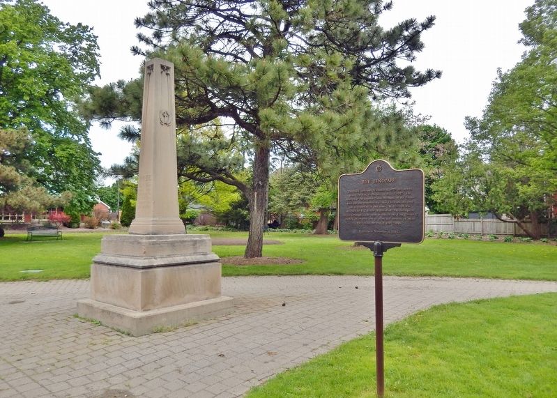
Originally dedicated November 11, 1923, and moved from Gore Park to this site on June 2, 1992. The members of the Imperial Order Daughters of the Empire were the sole contributors to this Cenotaph, the only one in Brantford at that time. The . . . — — Map (db m243640) HM WM
In the 1820's significant improvements to the Hamilton and London road attracted settlers to the Indian lands at Brant's Ford where this thoroughfare crossed the Grand River. A thriving village soon developed and in 1830 the Six Nations surrendered . . . — — Map (db m199047) HM
Invention of the Telephone
Even here at his father's home where he came for rest
and peace, Alexander Graham Bell continued to ponder
the elusive secret of voice transmission, and it was here,
on 26 July 1874, that insight finally . . . — — Map (db m230396) HM
The Mohawk Institute
The Mohawk Institute was established in 1831 for children of the Six Nations Iroquois living on the Grand River. Pupils from other native communities in Ontario attended the school as well. Like all Canadian . . . — — Map (db m230264) HM
A Brief History...
• 11,000 Years Ago - Nomadic hunter/ gatherer culture in tundra-like environment of the Grand River Valley.
• 9000 Years Ago - Hunter/gatherer culture begins to implement seasonal migratory camps.
The environment has . . . — — Map (db m240764) HM
Tomb Inscription
This tomb is erected to the memory of THAYENDANEGEA , or Captain Joseph Brant, Principal Chief and Warrior of the Six Nations Indians, by his Fellow-Subjects, admirers of his fidelity and attachment to the British . . . — — Map (db m83696) HM
Victoria Park was set aside as a square when Lewis Burwell surveyed the original town plan for Brantford in 1830. The square was first landscaped as a formal park in 1861. The plans were prepared by John Turner, a local architect who designed many . . . — — Map (db m215847) HM
[English] An outstanding sculptor of some of Canada's finest public monuments, Walter Allward is best known for his masterpiece, the Vimy war memorial in France. He emerged as a dominant figure in the transition from . . . — — Map (db m215699) HM
[English] A leading spokesman for Canadian agrarian and co-operative movements, Good was born and raised on Myrtleville farm. He early developed a strong sense of social responsibility and, returning here after attending the . . . — — Map (db m217700) HM
Landscape with Tree, oil on board, n.d. Collection of Glenhyrst Art Gallery of Brant William Henry Clapp was born in Montreal to American parents in 1879. In 1904 he left Canada to study art at l'Academie Julian in Paris, France. By . . . — — Map (db m221779) HM
In 1869, on the recommendation of the Rev. Egerton Ryerson, Superintendent of Education, funds were allocated to establish the first provincial school for blind children. The Ontario Institution for the Education of the Blind, which included the . . . — — Map (db m230229) HM
In October, 1814, an invading American force of about 700 men under Brigadier-General Duncan McArthur advanced rapidly up the Thames Valley. He intended to devastate the Grand River settlements and the region around the head of Lake Ontario which . . . — — Map (db m78341) HM
[English] Completed in 1856, Chiefswood owes its importance to its architecture and the prominence of the people who lived here. Derived from the popular Italianate style of the Picturesque movement, the grandeur of the house . . . — — Map (db m209067) HM
English: An Onondaga from the Six Nations of the Grand River, Tom Longboat was one of the world's great long-distance runners. He ran his first race in Caledonia in 1905 and two years later shot to international attention with a . . . — — Map (db m83700) HM
In this house "Chiefswood", erected about 1853, was born the Mohawk poetess Emily Pauline Johnson (Tekahionwake). Her father, Chief G.H.M. Johnson a greatly respected leader of the Six Nations, built "Chiefswood" as a wedding gift for her English . . . — — Map (db m208900) HM
[English] Born here at Chiefswood, the daughter of a Mohawk chief, E. Pauline Johnson gained international fame for her romantic writings on Indian themes, but she also wrote about nature, religion and Canadian nationalism. . . . — — Map (db m209066) HM
English:
This celebrated Mohawk chief of Canajoharie Castle and Johnson Hall grew up in the Mohawk Valley. He received his baptism of fire at the battle of Lake George in 1755. He served with Sir William Johnson in the Niagara . . . — — Map (db m83714) HM
English:
Commemorating the loyal services and unswerving fidelity of the Six Nations of Iroquois Indians to the British Empire in the Seven Years War, 1755 - 1763, the War of the American Revolution, 1775 - 1783, and in the defence of . . . — — Map (db m83712) HM
Lest We Forget
1914 - 1918
Lt. Brant, Cameron D. • Lt. Moses, James D. • Arron, William • Claus, Issac • Curley, Lloyd • Fish, Reuben • Garlow, James • Goosey, David • Groat, Samuel B. • Hill, Hiram • Hill, Roy • Homer, Harrison • . . . — — Map (db m83744) WM
English
John Brant was born in the Mohawk Village (Brantford), the youngest son of the renowned Joseph Brant. He was educated at Ancaster and Niagara, and fought with distinction during the War of 1812. Brant devoted his life to improving . . . — — Map (db m78340) HM
Dr. Charles Duncombe (1791-1867), prominent physician and politician, was leader of the militant reform movement in the London District at the time of the Rebellion of 1837. He rallied the local "Patriots" at the settlement of Scotland, planning to . . . — — Map (db m189196) HM
In 1914, the Scotland Women’s Institute donated this historic bell to be mounted atop the original Scotland Library, located beside the “Garden Wall” house. The bell was rung three times daily, at 6 a.m., 12 Noon, and 6 p.m. In 1932, the Scotland . . . — — Map (db m221713) HM
Adelaide Hunter was born in this farm house and lived here until she married John Hoodless in 1881. On February 19, 1897, she organized at Stoney Creek the world’s first Women’s Institute. It was her belief that in this organization rural women . . . — — Map (db m208855) HM
[English] Born in Ontario, Adelaide Hoodless sought to release the full potential of women for social action. An outspoken educator and social reformer, she successfully pressed for acceptance of Domestic Economy as a subject for . . . — — Map (db m208860) HM
In recognition of three generations of the Nixon family, who represented the residents of the County of Brant between 1919 and 2004 both Provincially and Federally, this portion of Highway #5 is being designated as the “Nixon Way.” — — Map (db m243520) HM
To our Men & Women who served in World War II & Korea Allen, Edsel ☆22/5/1944 • Allen, Edward • Allen, W. • Alysworth, A. • Anderson, Douglas • Anderson, C. • Andrews, Leslie • Attridge, Donald • Bailey, J. • Barker, Leslie • . . . — — Map (db m243538) WM
This building was presented in memory of Salem Griswold Kitchen by his wife was remodeled by the citizens of the community and is a memorial to the soldiers who fought in the Great War These made the supreme sacrifice Armstrong Walter N . . . — — Map (db m243442) HM WM
[English] Built in 1859 by the Department of Public Works, this handsome 26 m structure is one of six “Imperial towers” on these shores. The circular limestone tower has walls 150 cm thick at the base, tapering to 61 cm at the top. The . . . — — Map (db m198318) HM
Pump House A brick building was constructed in 1887 for the purpose of providing fire protection to a portion of the village. A well was dug in the basement of the pump house with a pipe extending to the Saugeen River. A steam engine of 4 . . . — — Map (db m198320) HM
In 1852, shortly after this region was opened for settlement, the government reserved land for a town here on the Elora and Saugeen Road, at the confluence of the Teeswater and Saugeen Rivers. Already settled on the site were Simon Orchard and . . . — — Map (db m198319) HM
County of Carleton
Agricultural Society
1844 - 1944
Presented by
Ontario Department of Agriculture
in recognition of
One Hundred Years Service
September 8th 1944 . . . — — Map (db m109968) HM
Built before 1863 in Classical Revival Style, this building began its life as a store operated by George Brown in 1863 and then by James and Robert Brown around 1900. The first floor was used as a bank from 1905 to 1970 but the Loyal Orange Lodge . . . — — Map (db m109972) HM
In August, 1818, some thirty disbanded veterans of the 99th Regiment, led by Captain G.T. Burke, arrived in newly surveyed Goulbourn Township. These formed the advance party of a military settlement planned and supported by the . . . — — Map (db m109965) HM
St. Andrew's was the first Presbyterian congregation in Carleton County and was served primarily by itinerant preachers until the 1840's. A wooden church was constructed on this site in 1847 and replaced by the present brick church and spire in . . . — — Map (db m109970) HM
Upon sighting American war ships at the mouth of the Thames River on October 1, 1813, the British Army boarded scows and bateaux near this site. One by one, the boats and their cargo were pulled across the river to their next encampment site at . . . — — Map (db m184677) HM
While British Army was encamped at Dolsen's, Procter travelled to Fairfield to investigate the site as a defensive position. At Tecumseh's urging, and learning that the Americans were closing rapidly, Colonel Warburton, Procter's second-in-command, . . . — — Map (db m71360) HM
East of the Forks, the Thames River becomes shallower and not navigable for larger ships. With the American forces close behind, the British vessels were threatened with capture. One cargo ship, probably the Miamis, had already been set on fire . . . — — Map (db m71398) HM
There were many casualties at the skirmish at the Forks. Although we do not presently know the identities of the warriors who were killed, we do know that two Kentucky men in Colonel Johnson's Mounted Infantry lost their lives at this site on that . . . — — Map (db m71379) HM
The Chatham Armoury was constructed in 1905 as a result of reform and expansion of the volunteer militia. The first unit to occupy the Armoury was the 24th Kent Regiment that was formed in 1901. It was the centre for local recruitment and training . . . — — Map (db m71382) HM
On this site a blockhouse was constructed in 1794 by order of Lieutenant-Governor John Graves Simcoe. He planned to establish here a small naval arsenal which would form a link in the defences of Upper Canada's western frontier and also draw the . . . — — Map (db m71313) HM
Thomas McCrae was an early settler, innkeeper, and political figure in Raleigh Township along the Thames River. He served as a captain and company commander in the Kent Militia and was present at the capture of Fort Detroit. Family tradition relates . . . — — Map (db m71308) HM
On May 10, 1858, American abolitionist John Brown held the last in a series of clandestine meetings here at First Baptist Church. Brown planned to establish an independent republic within the United States and wage guerrilla war to . . . — — Map (db m71386) HM
In 1847 the Kent District was established and authority was given for the erection of a court house and jail at Chatham. One year later construction began according to plans submitted by the prominent Canadian architect William Thomas. Designed in . . . — — Map (db m198312) HM
Following the defeat of the British at the Battle of the Thames on October 5, 1813, American forces controlled the Thames Valley west of Moraviantown. In early December a detachment of 3 officers and 36 men of the American 26th Regiment established . . . — — Map (db m71292) HM
During the American occupation of the lower Thames, this house was used as a base for U.S. troops. In mid-December 1813, the house was occupied by 39 officers and men of the 26th Regiment led by Lieutenant Larwill.
At the same time, a group of . . . — — Map (db m71310) HM
On October 2, 1813, Tecumseh moved his warriors up-river to the Forks where he had been led to believe that fortifications would be prepared for a full-scale confrontation with harrison's army. When Tecumseh arrived, he was enraged to find no . . . — — Map (db m71335) HM
Robert McAfee, a member of Colonel Johnson's Kentucky Mounted Regiment, described the skirmish in his journal. He wrote:
Oct 4: …a woman … informed us that about six miles above the River forked, that there was a large bridge across the mouth . . . — — Map (db m71378) HM
On this site, Tecumseh, a Shawnee Chief, who was an ally of the British during the War of 1812, fought against American forces on October 4, 1813. Tecumseh was born in 1768 and became an important organizer of native resistance to the spread of . . . — — Map (db m71322) HM
From 1783 until the 1860s, abolitionists in British North America took part in the fight to end slavery both at home and in the United States. Thanks to the determination of colonial officials, anti-slavery organizations, and the thousands of . . . — — Map (db m71391) HM
The Forks of the Thames are formed by the joining of the Thames River and McGregor Creek creating a peninsula that is present day Tecumseh Park in Chatham, Ontario. The strategic importance of the site was recognized by Lieutenant Governor John . . . — — Map (db m71331) HM
The Paw Paw tree (Asimina triloba) is native to the southern, eastern, and mid-western United States and extends to Canada only in the extreme southern part of Ontario. It has the largest edible fruit native to North America. The fruit looks . . . — — Map (db m71405) HM
This house belonged to James Harris and his family, who are believed to be descendants of Weldon Harris, an African American who came to Canada and in 1825 purchased 50 acres on Lot 3, Concession 3 in Camden Township. Weldon Harris made . . . — — Map (db m78404) HM
English
Built in the mid-19th century, this house was the last residence of Josiah Henson and his second wife, Nancy Gambril, who lived in it until Henson’s death in 1883. Henson’s house was substantial in size compared to other . . . — — Map (db m78387) HM
After escaping to Upper Canada from slavery in Kentucky, the Reverend Josiah Henson became a conductor of the Underground Railroad and a force in the abolition movement. The founder of the Black settlement of Dawn, he was also an . . . — — Map (db m78377) HM
This area was once covered in a thick, growth of trees including black walnut, maple, beech, elm and white oak. To make use of these natural resources, Josiah Henson and his sons used donations from benefactors in Boston to build a . . . — — Map (db m78402) HM
Built around 1850, this modest rural church was moved from Mersea Township to this site in the 1960s and is representative of the churches in which Reverend Henson preached while living at Dawn.
Reverend Josiah Henson was most . . . — — Map (db m78388) HM
In the 1830s, the Reverend Josiah Henson and other abolitionists sought ways to provide refugees from slavery with the education and skills they needed to become self-sufficient in Upper Canada. They purchased 200 acres of land here in . . . — — Map (db m78376) HM
In 1846 Daniel van Allen, a Chatham merchant, laid out a town plot on land purchased from Jared Lindsley, the first settler (1825) on the site of Dresden. By 1849 the erection of a steam sawmill, and the operation a grist-mill in the neighbouring . . . — — Map (db m78416) HM
On November 7, 1763 a fleet of small boats carrying nearly 700 officers and men of the 60th and 80th Regiments under Major John Wilkins was forced ashore by a violent storm abut three miles east of this point. The expedition had set out from Niagara . . . — — Map (db m108505) HM
As Lieutenant Colonel James Johnson's horsemen were charging the British front line, his brother, Colonel Richard Johnson led an attack against the First Nations warriors in Backmetack Marsh. The mounted infantry charged the Native left flank led by . . . — — Map (db m233828) HM
In September 1813, during the second year of the War of 1812, the United States won control of Lake Erie, cutting British supply lines with the east and forcing the British to withdraw from the Detroit River region. Then, on October 5, . . . — — Map (db m78367) HM
The Moravians or "Bohemian Brethren" were a protestant sect that originated in the 1400s in Moravia and Bohemia, the present day Czech Republic. They faced persecution in their homeland and in 1722 many moved to Saxony (now part of Germany) where . . . — — Map (db m72448) HM
(Front of monument)
Fairfield on the Thames / Fairfield sur la Thames
Here stood the village of Fairfield, destroyed by invading American forces following the Battle of the Thames. , 5th October, 1813.
Its inhabitants, Delaware . . . — — Map (db m116758) HM
Jacques (James) Baby 1763-1833: A member of the Legislative and Executive Council for Upper Canada, judge for the Western District, and in command of the 1st Kent Militia, Baby was captured by the Americans at the Battle of the Thames.
Billy . . . — — Map (db m71415) HM
Makataimeshekiakiak, Black Hawk, 1767-1838: A Sauk war leader and experienced warrior, Blackhawk was a veteran of the Battles of Fort Meigs and Fort Stephenson. Although he left the war for a period of time, he rejoined the British, and scholars . . . — — Map (db m71418) HM
Shabbona 1775-1859: A Potawatomi chief, grand nephew of Pontiac, and veteran of Tippecanoe, Shabbona was an accomplished warrior and strong supporter of Tecumseh. He persuaded many natives to join the confederacy.
Sou-veh-hoo-wah, Split Log, . . . — — Map (db m71419) HM
John Adair 1757-1840: Pioneer, soldier, and statesman, Adair was a veteran of the American Revolution, was 8th governor of Kentucky, and represented that state in both the U.S. House of Representatives and the Senate. He fought at the Battle of the . . . — — Map (db m72381) HM
James Johnson 1774-1826: The brother of Richard Johnson, James was elected as a Kentucky State senator in 1808. He served as a lieutenant colonel in Johnson's Mounted Infantry and led the charge on the British lines at the Battle of the Thames along . . . — — Map (db m72385) HM
Isaac Shelby 1750-1826: Shelby was the 1st and 5th governor of Kentucky and a veteran of the American Revolution. As governor and at 63years of age, Shelby personally led the Kentucky Militia at the Battle of the Thames.
Tarhe 1742-1816: A . . . — — Map (db m72388) HM
By the early morning of October 5, 1813, the American Army had forded the Thames River and was advancing quickly. The British rearguard was able to destroy Cornwall's mill, west of Sherman's farm (present-day Thamesville, Ontario) but not the mill . . . — — Map (db m71413) HM
Born in a Shawnee village in what is now Ohio, Tecumseh became in the 1770s co-leader with his brother, the Prophet, of a movement to restore and preserve traditional Indian values. He believed a union of all the western tribes to drive back white . . . — — Map (db m71410) HM
Many of the men of the 41st Regiment had been stationed in Canada for 13 years. By October 5, 1813, they had not been paid for 6 to 9 months; they lacked tents and blankets; their uniforms were in rags; they were plagued by a variety of diseases; . . . — — Map (db m72393) HM
Robert McAfee, a soldier in Colonel Johnson's Mounted Regiment, kept a journal of his experiences, and wrote on October 7, 1813:
Spent the day in collecting in plunder ... Colonel Owings Regiment of Regulars came up and took charge of the . . . — — Map (db m72414) HM
At some point during the attack on Backmetack Marsh, Tecumseh was fatally shot. As word spread of their leader's death, one American account tells of the warriors giving, "the loudest yells I ever heard from human beings and that ended the fight." . . . — — Map (db m72405) HM
Some British officers involved reported that, due to the proximity of the enemy and the fact that the troops were exhausted and hungry, they were unable to outpace the American mounted units to Fairfield. Another theory is that Procter sought to . . . — — Map (db m71414) HM
Cochrane has a proud history of farming in the North. More specifically potato farming, with roots dating back more than a century. Cochrane donned the title "Potato Kings" in 1953 when local resident Gabriel Kolomeitz was presented a gold watch by . . . — — Map (db m217897) HM
The surveying of the line which intersects Highway No. 11 here (survey mile post 162) was the first step taken by the Ontario government in the exploration and development of this region. During the 1890s, interest in Ontario's northern mineral, . . . — — Map (db m217895) HM
[English] For centuries the site of Cochrane was used by indigenous peoples as a summer camping ground. Later it became a stopping place for fur traders en route to Moose Factory. In 1907 the Temiskaming and Northern Ontario Railway . . . — — Map (db m217898) HM
[English] A Hudson's Bay Company post named after a son of George III, Frederick House was established in 1785 to prevent Canadian fur traders in the Abitibi region from intercepting the passage of furs to Moose Fort (Moose Factory) . . . — — Map (db m217973) HM
Erected by the citizens of Iroquois Falls and the directors of the company to the memory of Frank Harris Anson 1859-1923 founder and first president of Abitibi Power and Paper Company Limited. — — Map (db m245618) HM
Was and continues to be recognized country wide. It was clear from the onset this town was to reflect strong and fresh designs complete withGarden Town Themes Our town is claimed as being the first planned community in Canada. Research . . . — — Map (db m245498) HM
A new IFPS officially opened on January 16, 1941. At the time Mr. J. L. Harkness (1941-1958) was the principal. In 1977 a new gymnasium was constructed with Mr. Alan Taylor (1958-1985) as principal. In 2006 the school was demolished and . . . — — Map (db m245458) HM
[English] This region's first inhabitants were aboriginal peoples who were attracted by its abundant natural resources and extensive water routes. Europeans arrived in the late 1600s to acquire furs and establish trade with the . . . — — Map (db m217890) HM
The Trueman Gibbens and the Clark Davis Boats were transported from Owen Sound by train and were assembled and launched in Lowbush in 1947 and 1951 respectively. Specifically designed for work in the shallow waters of Lake Abitibi of depths less . . . — — Map (db m245499) HM
The year is 1880 when Ephraim Shay (1839-1916), a man with inventive and mechanical ability, developed a powerful and agile locomotive that could climb, turn and operate on uneven ground. On February 27, 1926, the SHAY 70 rolled off the assembly . . . — — Map (db m245500) HM
Born in Latchford and raised near Porquis Junction, Cosens enlisted in the Argyle and Sutherland Regiment, Canadian Active Service Force, in 1940 and transferred to the Queen's Own Rifles of Canada in 1944. Early on February 26, 1945, his unit . . . — — Map (db m217896) HM
On July 29, 1916, fires which had been burning for some weeks around settlers' clearings along the Timiskaming & Northern Ontario Railway were united by strong winds into one huge conflagration. Burning easterly along a 40-mile front, it largely or . . . — — Map (db m217800) HM
This village had been named originally after an Indian trapper by the name of MacDougall who was descended from an early Hudson’s Bay Factor. With the arrival of the Temiskaming and Northern Ontario Railway in 1906, the village was renamed Matheson . . . — — Map (db m244994) HM
The chute was a narrow, fast water part of the Black River located approximately 1.0 km above the highway 101 bridge. It was here that the MacDougall family and their friends set up an encampment during their journeys through the area. The chute . . . — — Map (db m244991) HM
[English] From the 1880s onwards, as railways opened up northern Ontario, prospecting activity in this region intensified. The Porcupine gold rush began in 1909 following three significant discoveries. Thousands of prospectors and . . . — — Map (db m217899) HM
[English] There is no shortage of stories about the prospectors who came north during the Porcupine Gold Rush of 1909. Life was not easy; they carried 75-pound packs through muskeg and uneven ground. Of course nothing was certain . . . — — Map (db m199240) HM
[English] In the summer of 1911, when the Porcupine gold rush was at its height, the weather was hot and dry. On July 11, gale-force winds from the southwest whipped individual bush fires into a 16-km sea of flames that swiftly . . . — — Map (db m217900) HM
Official opening: January 16, 1939 Reeve: Victor H. Evans Council: George Helmer, Melvin Cavanagh, Emil Heino, William Fairhurst Last council at amalgamation: December 31, 1972 Reeve: Ernie R. White Council: Dennis Pope, Maurice Londry, Luigi . . . — — Map (db m244988) HM
[English] Timmins is one of the richest gold producing areas in the world; the Porcupine Gold Rush led to the extraction of well over 65 million ounces of gold to date and by comparison, the Klondike Gold Rush coaxed out just over 5 . . . — — Map (db m244434) HM
[English] The first French-language radio station in Ontario, CFCL-Timmins, began broadcasting in December 1951. The event was greeted with enthusiasm by Franco-Ontarians who until then had heard limited programming in French over . . . — — Map (db m217793) HM
[English] After the Cariboo and Klondike rushes, gold production in Canada entered a new era with the discovery of lode deposits in the Porcupine area in 1909. The mines in this district, notably the Hollinger which became one of . . . — — Map (db m199247) HM