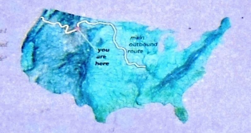
You are standing at the headwaters of the great Missouri River. The Jefferson and Madison Rivers converge with the Gallatin joining one mile downstream to become the Missouri River. Here, the famed explorers accomplished a major goal of their . . . — — Map (db m73542) HM
The Headwaters has been populated for over 11,000 years
The Headwaters region was occupied for more than 11,000 years by bands of hunter and gatherers. Ample big game such as bison, elk and deer, and the abundant natural rock for tool . . . — — Map (db m192724) HM
This statue was erected to commemorate Sacajawea and the Bicentennial of the Lewis and
Clark Expedition of 1803- 1806. She was a member of the Corps of Discovery and was invaluable as an interpreter in obtaining horses from her Shoshone people, . . . — — Map (db m98496) HM
Familiar with the Headwaters area, Sacajawea was invaluable as an interpreter for Lewis and Clark.
In 1800, Sacajawea was camped on the Jefferson River with her Shoshone tribe. Attacked by a band of Minnetarees, she was captured and . . . — — Map (db m192793) HM
Many nations traveled and lived along these banks, giving their own names to
the river. “Missouri” is the official name given by the U.S. Geological Survey. It
dates back to French explorer Jacques Marquette’s journal and 1673 map of . . . — — Map (db m99215) HM
This region was alive with beaver, otter and game before the white man came. It was disputed hunting territory with the Indian tribes. Sacajawea, the Shoshone squaw who guided portions of the Lewis and Clark Expedition, was captured near here when a . . . — — Map (db m126978) HM
Easy river access and large numbers of beaver made the Headwaters a logical place for the ... Three Forks Post - 1810
In 1810, Manuel Lisa of the Missouri Fur Co. sent a large party of 32 trappers under command of Pierre Menard . . . — — Map (db m192792) HM
This basin was settled by ranchers and homesteaders.
Bannock Indians had encampments here as late as 1913. Near
here is the west entrance to Yellowstone Park, the nation’s
first National Park(1872). West Yellowstone was founded in
1908 with the . . . — — Map (db m100066) HM
Until the early 1880s this portion of Montana was wild and unsettled country. Various Indian tribes used this region for hunting bison and gathering other resources. Many of these tribes lived in tipis. Most tribes used a tripod when raising the . . . — — Map (db m143335) HM
Fort Musselshell was located on the Missouri River about 35 miles north of here. It was a trading post in the ’60s and ’70s and as such had a brief but colorful career. The only whites in that part of the state were woodchoppers for the Missouri . . . — — Map (db m9698) HM
Competition to supply the mining camps was fierce in Montana in the 1860s. Many opportunists realized that the real money was not in mining for gold, but in “mining the miners” by providing essential goods and services. Fort Benton . . . — — Map (db m9700) HM
The Blackfoot Nation consist of three tribes, the Pikunis or Piegans, the bloods and the Blackfoot. Each tribe is divided into clans marking blood relationship. The majority of the Indians on this reservation are Piegans.
Many years ago the . . . — — Map (db m130198) HM
Women, and especially club women, played outsized roles in creating and maintaining the community institutions - churches, schools, and libraries - that they and their families valued. Providing an outlet for women to exercise their leadership . . . — — Map (db m161119) HM
The second Indian Agency on the Blackfeet Reservation was built at Old Agency in 1879. Agent John Young moved the buildings from Upper Badger Creek with help from the Blackfeet Indians. Both men and women dug cellars, hauled stone and mixed mortar. . . . — — Map (db m130200) HM
In 1879, the Blackfeet agency was moved to this site from a previous site south of here to encourage the Blackfeet to take up farming. Old Agency was also the site of where over 600 Blackfeet starved to death, which is known as "The Starvation . . . — — Map (db m130211) HM
Chief Mountain, NINA-STA-QUAY, has alway been known to the Blackfeet people. Identified on maps as King Mountain as early as 1796, this outstanding landmark has long been revered for its supernatural powers. Generations of Blackfeet have used Chief . . . — — Map (db m220323) HM
With the disappearance of the buffalo in 1883, the entire tribe depended on the Agency for food. The agency failed to provide adequate rations during that winter, which resulted in over 600 tribal members starving to death. They were buried along . . . — — Map (db m130213) HM
With the buffalo gone the Indian was completely dependent on the Indian Agency. Food rations of meat and a variety of foods and materials were issued once a week per family. — — Map (db m130212) HM
The Nez Perce people, under the leadership of their Great Chief Joseph crossed the Musselshell River near here on September 17, 1877. They had left their Idaho homeland in a valiant but futile effort to reach Canada. Their march marked by several . . . — — Map (db m188961) HM
In July 1878, a band of Nez Perce Indians returning south from Canada after eluding U.S. Cavalry, crossed what is now Granite County. While passing through they attacked a small mining camp located on a tributary of Rock Creek at McKay Gulch. Three . . . — — Map (db m45211) HM
Indian people have lived in this area for at least 11,000 years. Throughout that time, buffalo were their primary source of food. The Indians devised ingenious way to hunt buffalo with the buffalo jump, or pishkum, the best known. At pishkuns, . . . — — Map (db m142644) HM
Immense herds of bison once roamed the great North American prairies. As many as 30 million of the great shaggy beasts moved seasonally in herds of 25 to 300, following the same patterns year after year. Bison, or buffalo, were the lifeblood of the . . . — — Map (db m142638) HM
In August 1840, Pierre Jean De Smet, a Catholic missionary of Belgian birth, camped near the mouth of the Boulder River with the Salish Indians and celebrated the holy sacrifice of the Mass. Father De Smet left the Indians soon after to go to St. . . . — — Map (db m128362) HM
For thousands of years, western Montana, including the Jocko Valley, has been home to the Qluspé (Kalispel or Pend d'Oreille) and Séliš (Salish or "Flathead") people. In their tradition creation stories, tribal elders tell how Coyote . . . — — Map (db m159542) HM
The 1887 Dawes Act gave Congress the power to survey Indian reservations, assign land (allotments) to individual Indians, and open the remaining land to homesteaders. Although tribal leaders, including Chief Charlo and Sam Resurrection, resisted . . . — — Map (db m219655) HM
In the 1855 Treaty of Hellgate, leaders of the Salish ("Flathead"), Pend d'Oreille, and Kootenai tribes ceded to the United States most of their lands west of the Continental Divide. The tribes, however "reserved" certain areas, including this . . . — — Map (db m219146) HM
This church, dedicated to St. Ignatius of Loyola, founder of the society of Jesus, was built in 1891. In 1840, Fr. Peter DeSmet came to Montana in response to the request of four separate delegations of Indians, and in 1841, he established St. . . . — — Map (db m219042) HM
"..to take a small party & to proceed on up the river, some distance before the canoes, in order to discover them (Indians), should they be on the river before the daily discharge of our guns, which was necessary in procuring substance, . . . — — Map (db m245679) HM
For many thousands of years, travelers of every description have traversed the Blackfoot River corridor. As you drive Highway 200, alongside the boulder-strewn rapids of the fabled Blackfoot River, envision the journeys, some pleasurable, others . . . — — Map (db m219983) HM
Bison! This great shaggy beast sustained the Indians of the Plains and adjacent areas for thousands of years. And in these parts we call Montana, an ancient network of trails led the Salish, Pend d'Oreille, and related Indian tribes, who . . . — — Map (db m220033) HM
The Sweet Grass Hills posses special significance to the Blackfeet Indians and to other tribes on the northern Great Plains. According to legend, the creator Napi fashioned the hills in the dim past out of rocks left over from the formation of the . . . — — Map (db m161397) HM
About 15,000 years ago, this area was covered by huge glaciers which formed unique geological formations throughout the valley called drumlins or hills composed of glacial till deposited beneath the glaciers.
Ice periodically dammed up the . . . — — Map (db m113518) HM
The land around Kootenai Falls has been explored and used for thousands of years by the Kootenai or Tunaxa People. The Kootenai tribe made up of seven bands, two in U.S. and five in Canada.
European traders and surveyors were lured to the region . . . — — Map (db m127287) HM
The river is named for the Kootenai tribe that lived and hunted in this part of Montana and adjoining territory in Idaho and Canada. They were settled south of Flathead Lake in 1855 with the Salish on the Flathead Reservation.
They were . . . — — Map (db m71509) HM
The Ruby River was called the Passamari by the Shoshoni Indians and the Stinking Water by the miners in the early 1860's.
Later, it was mistakenly renamed the Ruby, although the gems found along its length were actually garnets.
The . . . — — Map (db m116998) HM
August 1805 - The Corps of Discovery struggled upriver toward the Rockies. Illness and injury, along with the increasingly difficult river passage, had eroded the group's morale. But the afternoon of the 8th brought a much needed lift, when . . . — — Map (db m193127) HM
Beloved Members of the
Corps of Discovery
This Memorial was made
possible by the generosity of
the
People and Friends of Madison
County
Sculpted by Dick and Sandi Crane — — Map (db m193049) HM
In, early August, 1805, the Lewis and Clark Expedition, westward bound, came up the Jefferson River and passed through this area. The valley was an ancient travel corridor; Lewis noted the presence of an "old Indian road" near the Big Hole River. . . . — — Map (db m116997) HM
Meriwether Lewis, Touissaint Charboneau, Patrick Gass and George Drewyer, the vanguard of the Lewis and Clark Expedition and the first white men to enter this valley, camped on the east bank of the Beaverhead River, two blocks west of here, on . . . — — Map (db m128399) HM
The discovery of gold, silver, lead and copper in this area brought about the establishment of Camp Baker in 1869 to protect settlers from Indian raids.
Named Fort Logan in 1877, the post was abandoned in 1880.
The block house which . . . — — Map (db m127844) HM
For millennia, the Blackfoot River corridor has been part of the homeland of the Salish and Pend d'Oreille people. They and visiting members of other tribes used a vast network of trails to criss-cross this region of great abundance -- rich in game, . . . — — Map (db m123101) HM
Native Travelers at Tmsmli
You are standing at the heart of a well-used campsite and gathering place used by people for thousands of years. Traveling along time-worn trails from the four directions, families, hunters and explorers came . . . — — Map (db m123237) HM
Since Coyote first prepared this place for human beings, the Bitterroot Valley has been the homeland of the Salish-speaking peoples of western Montana -- the Qlispé (Kalispel or Pend d'Orielle) and the closely- related Selíš (Bitterroot Salish or . . . — — Map (db m142734) HM
The route that lies west of here, the Lolo Trail, was different from other east-west 19th century Americans trails. It did not witness a flood of cross-county migration. There were no covered wagons here.
Unmapped and shifting over time, it . . . — — Map (db m123123) HM
Sikum is the Nez Perce word for horse. The Nez Perce people were introduced to the horse in the 1730’s. The word “appaloosa” was created by white settlers. The Nez Perce learned through selective breeding that they could . . . — — Map (db m123126) HM
On the morning of July 3, 1806, Lewis and Clark set in motion a dangerous plan to separate, and explore different routes on their return journey to the Missouri River. As he was both excited and anxious to pursue a rumored shortcut, Lewis wrote: . . . — — Map (db m123331) HM
The narrow river canyons upstream from here have a long and bloody past.
As the Salish, Nez Perce and other western mountain Indian tribes passed through these canyons enroute to buffalo hunting grounds east of the Rocky Mountains, they were . . . — — Map (db m123334) HM
For three months the members of the Nez Perce non-treaty bands had been constantly on the move evading the military. Scouts ranged in front and guarded behind the traveling village of mostly children, women and old people, as they sought safety and . . . — — Map (db m130230) HM
The Absaroka - Beartooth Wilderness, which lies to the east, contains one of the largest single expanses of land above 10,000 feet in elevation in the United States. The U.S. Forest Service set aside portions of the region as primitive areas in . . . — — Map (db m123116) HM
In August 1864,three emigrants, who came to Montana on the Bozeman Trail, arrived here and found men already hard at work mining the creek. The new arrivals decided to try their luck farther up the rugged gulch, finding pay dirt high up the side of . . . — — Map (db m46256) HM
This statue commemorates Sacajawea, whose loyalty, courage and, devotion were instrumental in the success of the Lewis and Clark expedition of 1803-1806.
Holding her infant son Jean Baptiste Charbonneau (nicknamed "Pomp" by Capt. Wn. Clark), she . . . — — Map (db m191659) HM
(Three panels make up this marker:) Yellowstone River:
Haven for Great Hers of Wildlife
July 24, 1806
"Saw emenc number of Deer Elk and buffalow on the banks. Some beaver...for me to mention or give an . . . — — Map (db m191921) HM
The area in front of you once served as south-central Montana's cultural crossroads. Especially between 1868 and 1875, this was a place where settlers and Indians traded goods and services, where the U.S. government sought (and failed) to convert . . . — — Map (db m193330) HM
The interstate highway nearby mirrors a path travelers have used for centuries. Even long before the days of Lewis and Clark, members of the Crow Tribe came to this area in an annual rendezvous that was central to their culture. The tribe's nomadic . . . — — Map (db m193329) HM
(Left panel:)
Early Exploration and Settlement:
John Colter, member of the 1804-1805 (sic) Lewis and Clark Corps of Discovery, in 1807 was the first known white man to have traversed through the area known as Yellowstone . . . — — Map (db m191799) HM
Sacajawea and her son traveled with Captain William Clark down the Yellowstone River passing through this area on July 15, 1806. Sacajawea was a Shoshone teenager whose knowledge of native tribes, languages, and geographical landmarks of the area . . . — — Map (db m191658) HM
Like much of Montana, the lands of the Mission Ranch still look largely as they did in the days of Lewis and Clark. Ranching, anchored as it is in the land's own natural productivity, is one of the main reasons. The grassland prairies and wooded . . . — — Map (db m193374) HM
Many Indian people believe that spirits dwell in north central Montana's "island" mountains: the Sweet Grass Hills and the Bear Paw and Little Rocky ranges. Their rugged peaks, clustered like tepees in a camp, offer access to the supernatural and . . . — — Map (db m162053) HM
Many Indian people believe that spirits dwell in north central Montana's "island" mountains: the Sweet Grass Hills and the Bear Paw and Little Rocky ranges. Their rugged peaks, clustered like tepees in a camp, offer access to the supernatural and . . . — — Map (db m162055) HM
Montana's native people revere this boulder that once perched high atop a wind-swept ridge overlooking the Cree Crossing on the Milk River. The ancient weather-worn effigy resembled the leader of a herd of reclining buffalo in an outcrop of gray . . . — — Map (db m142885) HM
(There are three panels to this marker:)
A Dispute Over Horses and Guns
Meriwether Lewis and three men from the Corps of Discovery traveled through this area on July 26, 1806. During the journey, the men encountered eight . . . — — Map (db m220403) HM
Captain Meriwether Lewis of the Lewis and Clark Expedition, accompanied by three of his men, explored this portion of the country upon their return trip from the coast. On July 26, 1806, they met eight Piegans (Blackfeet), who Lewis mistakenly . . . — — Map (db m127282) HM
You may have noticed a ring of rocks on the land before you. This is a tipi ring - a remnant of American Indian architecture. Like many other tribes, the Blackfeet tribe who lived in this area used tipis as moving homes.
The tipi was . . . — — Map (db m220405) HM
For thousands of years before the arrival of Europeans, American Indians thrived in what is now the American West. Many tribes depended on bison (buffalo) for food, clothing, shelter, trade, and much more. When white settlers set their sights on . . . — — Map (db m210110) HM
(This marker is constructed of three attached panels:)
The Blackfoot River Corridor
Welcome to the Blackfoot Recreation corridor. The corridor stretches 26 mile along the Blackfoot River from Johnsrud Park to the Russel Gates . . . — — Map (db m219981) HM
In 1970, Congress enacted a Wilderness Act and designated 43,000 acres north of Terry in the badlands as a Wilderness Study Area. The Calypso Trail and Scenic View offer a grand look at the badlands area. Father DeSmet met with the Hunkpapa Sioux . . . — — Map (db m203104) HM
When construction began on Hamilton’s post office in August 1940, the worst of the Depression was over. Nevertheless, the building is a legacy of the New Deal, when the number of federal construction projects soared to put people to work. Montana . . . — — Map (db m123552) HM
In the Hellgate Treaty negotiations (1855), Xwetxxcln (Plenty Horses or chief Victor) and the Selíš people rebuffed efforts of US officials to get them to abandon the choice lands of their ancestral Bitterroot Valley. After Xwetxxcln died, settlers . . . — — Map (db m123513) HM
From time immemorial, the Bitterroot Valley has been a central part of the aboriginal territory of the Salish people. Although the tribe is now based on the Flathead Indian Reservation north of Missoula, the Bitterroot remains a place of great . . . — — Map (db m123550) HM
Established in 1841 by Pierre DeSmet, S.J., in response to requests for Black Robes by four separate delegations sent by Flathead and Nez Perce tribes to St. Louis. Fr. DeSmet and his party erected Montana's first church immediately west on the bank . . . — — Map (db m123521) HM
Not a War Party
On September 4th, 1805, T chliska-e-mee (Three Eagles) the father of Chief Victor and grandfather of Chief Charlo, left camp to scout the area, fearing there might be some Indian enemies around intending to steal horses, . . . — — Map (db m123624) HM
(Three panels, presented left to right, make up this marker)
While here at Ross' Hole, (Sula, Montana) on September 4th, 1805, William Clark wrote in his journal: "Those people recved us friendly, threw white robes over our sholders & . . . — — Map (db m123599) HM
1 • Stanley Fur trappers from the Hudson’s Bay Company were the first to discover Stanley Basin during 1824. Stanley was named for Captain John Stanley, a Civil War veteran who brought 23 prospectors into the basin searching for gold. . . . — — Map (db m144160) HM
A Customary and Proper Welcome
The Salish people gave the strangers many gifts during their brief encounter here at the Great Clearing.
They gave their guests roots, berries, animal furs, and vital information about the trails and . . . — — Map (db m123625) HM
“Our people were camped in a kind of prairie along the Bitterroot River, a few miles upstream from the Medicine Tree. The place is called Ross’ Hole now; the Indians then called it Kwtít Pupxm.” --Pierre Pichette, Salish Tribal Elder . . . — — Map (db m123622) HM
is the home of two tribes, the Assiniboines, whose forefathers were living in this vicinity when Lewis and Clark came up the Missouri in 1805, and the Dakota (Sioux) descendants of the "hostiles" who fiercely resisted the white invasion of their . . . — — Map (db m142978) HM
Roll of Honor Indian Soldiers Who Died in Military Service Abbott, Sgt. Donald Ackerman, Pvt. Ray Archdale, S/Sgt. Percy J. Bauer, T/Sgt. Frederick (2) Bow, Pvt. Henry Connor, Pvt. Fred Crazy Bull, Pvt. Nathan (2) Dupree, Capt. . . . — — Map (db m203076) WM
Native peoples occupied the Little Bitterroot River Valley and enjoyed its healing hot springs long before European trappers and traders encroached upon local resources. In 1855, an 80-acre area around the hot springs was set aside as a government . . . — — Map (db m219652) HM
Native people hunted this area 9,000 years ago for bighorn sheep, elk and long-horned bison. Making “seasonal rounds” to specific locations, they maintained a comfortable lifeway by hunting, fishing and harvesting native plants. . . . — — Map (db m45191) HM
For thousands of years the Sqelixw—people of the Salish, Pend Oreille and Kalispel tribes—inhabited the valleys of the Clark Fork and other rivers of western Montana. They used their extensive knowledge of the natural world to create and . . . — — Map (db m45190) HM
By the second decade of the nineteenth century, the Hudson's Bay Company (HBC) had become a dominant presence in northwestern Montana, bartering trade goods for furs with the Kootenai, Pend d'Oreille, and Salish People. In 1812, the company built a . . . — — Map (db m219342) HM
"They go to Buffalo twice a year - first, 'to bulls' ... second 'for cows' ..." 1857, R.H. Lansdale, Indian Agent, Washington Territory
At Horse Plains "... a village of Indians collected here who never go for buffalo ..." . . . — — Map (db m219341) HM
Wild Horse Plains is nestled in a circular valley at an elevation of 2,450 ft., drained by the Clark Fork River. Between 70,000 and 130,000 years ago the Bull Lake ice age glaciers dammed the Clark Fork River Valley creating Glacial Lake Missoula. . . . — — Map (db m219335) HM
For many thousands of years, this area has been a favorite hunting, fishing and food-gathering area for the Olispé (Pend d'Oreille) people, many of whom live today on the Flathead Reservation. The Salish-language name for the Thompson Falls area is . . . — — Map (db m219422) HM
Seeing the country being denuded of beaver, Thompson wrote: "Every intelligent man saw the poverty that would follow the destruction of the beaver, but there were no chiefs to control it; all was perfect liberty and equality." David . . . — — Map (db m219424) HM
In November 1809, famed British North West Company agent and explorer David Thompson built a trading post about five miles east of here near the mouth of the Thompson River.
Strategically located on a well-worn aboriginal trail, Saleesh House was . . . — — Map (db m112921) HM
Sitting Bull was a great American Indian and Statesman. He struggled to keep his people free and united by fleeing with them into Canada. Louis Legare, a French trader and Sitting Bull’s friend, persuaded him to return to the United States and . . . — — Map (db m202834) HM
From 1875 to 1884, this was the site of the second Crow Indian agency. In 1875, the federal government ordered that the first agency be relocated from Mission Creek, east of present day Livingston, to remove the Crow people from the destructive . . . — — Map (db m190707) HM
Called Awaxaawippila by the Apsáalooka (Crow) Indians, The Crazy Mountains, which you can see to the northwest, are an igneous formation forged about 50 million years ago. For the Apsáalooka, they are the most sacred and revered mountains on the . . . — — Map (db m191042) HM
You are now following the historic trail of the Lewis and Clark Expedition. On his return from the Pacific in July 1806, Captain Clark camped for six days about forty miles downstream, near Park City. The Expedition had been looking for timber . . . — — Map (db m28948) HM
Called Awaxaawippiia by the Apsaalooka (Crow) Indians, the Crazy Mountains, which you can see to the northwest, are an igneous formation forged about 50 million years ago. For the Apsaalooka, they are the most sacred and revered mountains on the . . . — — Map (db m28947) HM
In 1866 William Thomas, his son Charles, and a driver named Schultz left southern Illinois bound for the Gallatin Valley, Montana. Travelling by covered wagon they joined a prairie schooner outfit at Fort Laramie, Wyoming, and started over the . . . — — Map (db m28975) HM
In the days of the fur traders and trappers, immediately following the time of the Lewis and Clark Expedition (1804-1806), all of this country bordering the Rocky Mountains from here north into Canada and south to the three forks of the Missouri and . . . — — Map (db m127284) HM
About 1/4 mile SE of this point, a huge native stone marks the site of “Old Agency” of the former Blackfeet Indian Reservation. The agency was established in 1868-69 and with unusual generosity, the whites in authority permitted . . . — — Map (db m127276) HM
From 1869 to 1885, supplies and trade goods that came up the Missouri River from St. Louis were transferred at Fort Benton from steamboats to freight wagons for distribution in southern Alberta on the famed Whoop-up Trail, which ran near here. In . . . — — Map (db m220444) HM
On January, 23, 1870, soldiers commanded by Colonel Eugene Baker killed 173 Blackfeet Indians in a surprise attack on Heavy Runner's camp near here on the Marias 1869. A man of peace, Heavy Runner had no quarrel with the US Army. His people did not . . . — — Map (db m161387) HM
In the summer of 1837 an American Fur Trading Company steamboat laden with trade goods made its way from St. Louis to Fort Union. Smallpox broke out among the crew, but the boat continued to its destination. Contact with the steamboat’s crew during . . . — — Map (db m142945) HM
The Coulson "Boothill" Cemetery
Residents of the town of Coulson, established along there banks of the Yellowstone River in 1877, buried their dead at the Coulson "Boothill" Cemetery, just below the Place of the Skulls. The cemetery was . . . — — Map (db m167883) HM
In 1837-38 a smallpox epidemic spread from the American Fur Trading Company steamboat St. Peter which had docked at Fort Union. The terrible disease for which the Indians had no immunity eventually affected all Montana tribes. A story is told among . . . — — Map (db m28814) HM