By Cosmos Mariner, August 26, 2021
Building Roads Marker (east side)
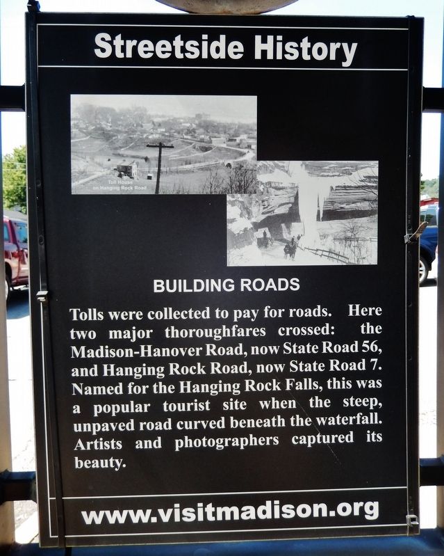
| On West Main Street (Ohio River Scenic Byway) (Indiana Route 56) just east of Cragmont Street (Indiana Route 7), on the right when traveling west. |
| On Michigan Road at West Street, on the left when traveling south on Michigan Road. |
| On N. Base Road, 0.4 miles south of Washington Street. |
| On North State Street (Indiana Route 3) 0.1 miles north of Bay Street, on the right when traveling north. |
| On East 2 Cent Road at East Old Plank Road (State Road 144), on the right when traveling east on East 2 Cent Road. |
| On Hurricane Road (County Road 400E) north of Tracy Road, on the right when traveling north. |
| Near South 6th Street Road west of Willow Street (Business U.S. 41). |
| Near South 6th Street west of Willow Street (Business U.S. 41). |
| Near South 6th Street west of Willow Street (Business U.S. 41). |
| Near South 6th Street Road west of Willow Street (Business U.S. 41). |
| Near South 6th Street Road west of Willow Street (Business U.S. 41). |
| Near South 6th Street Road west of Willow Street (Business U.S. 41). |
| Near South 6th Street west of Willow Street (Business U.S. 41). |
| Near South 6th Street Road west of Willow Street (Business U.S. 41). |
| On Willow Street (Business U.S. 41) 0.1 miles south of S. 10th Street, on the left when traveling south. |
| Near South 6th Street Road west of Willow Street (Business U.S. 41). |
| Near Old U.S. 30 at Road 350 N, on the left when traveling west. |
| Near Old U.S. 30 at County Road N350W, on the right when traveling east. |
| Near Old U.S. 30 at County Road N350W, on the right when traveling east. |
| On Main Street at Lake Street, on the right when traveling east on Main Street. |
| On N. Lake Street at Perry Street, on the left when traveling north on N. Lake Street. |
| Near Old U.S. 30 at County Road N350W, on the right when traveling east. |
| On North Columbia Street at North Lake Street, on the right when traveling north on North Columbia Street. |
| On Joliet Street (Road 30) west of Northwinds Drive, on the right when traveling east. |
| On Joliet Street (U.S. 30) west of Northwinds Drive, on the left when traveling west. |
| On Joliet Street (U.S. 30) west of Northwinds Drive, on the right when traveling east. |
| On US-30, Lincoln Highway, Joliet Street (U.S. 30), on the right when traveling east. |
| On North Broad Street at Columbia Avenue, on the right when traveling south on North Broad Street. |
| On Ripley Street (U.S. 6) 0.1 miles north of East 21st Place, on the right when traveling north. |
| On Van Buren Street at 73rd Avenue (Old Lincoln Highway), in the median on Van Buren Street. Reported missing. |
| On Joliet Street (U.S. 30) at Caroline Avenue, on the right when traveling east on Joliet Street. |
| On Joliet Street (U.S. 30) 0.2 miles east of Wicker Avenue (U.S. 41), on the right when traveling east. |
| On West Lincoln Highway Highway (U.S. 30) at Janice Drive, on the right when traveling west on West Lincoln Highway Highway. |
| On Madison Street at Lincolnway, on the right when traveling south on Madison Street. |
| Near Michigan Avenue at Washington Street, on the left when traveling north. |
| Near Michigan Avenue at Washington Street, on the left when traveling north. |
| On W. Michigan Blvd (U.S. 12) at Washington Street, on the right when traveling east on W. Michigan Blvd. |
| On U.S. 20 west of State Road 2, on the right when traveling east. |
| Near Indiana Route 60, 0.3 miles west of County Road 950E, on the right when traveling west. |
| On Martin Luther King Jr. Boulevard at West 25th Street, on the right when traveling north on Martin Luther King Jr. Boulevard. |
| On College Drive at University Boulevard, on the right when traveling north on College Drive. |
| On West Eighth Street near Lincoln Street, on the right when traveling east. |
| On Purdue Pkwy west of Scatterfield Road (Indiana Route 9), on the right when traveling west. |
| Near Dr. Martin Luther King, Jr. Boulevard (Indiana Route 38) at West 67th Street (Route W400S), on the right when traveling south. |
| On West Oak Street (County Road W1150N) just east of County Road N300W, on the right when traveling east. |
| On North Michigan Road (U.S. 421) north of Cold Spring Road. |
| Near Doctor M.L.K. Jr Street, 0.1 miles north of Crescent Avenue, on the right when traveling north. |
| Near North Blackford Street north of Indianapolis Cultural Trail, on the right when traveling north. |
| Near North Blackford Street north of Indianapolis Cultural Trail, on the right when traveling north. |
| Near North Blackford Street north of Indianapolis Cultural Trail, on the right when traveling north. |
| On South East Street at Fletcher Avenue, on the right when traveling north on South East Street. |
| Near North Blackford Street north of Indianapolis Cultural Trail, on the right when traveling north. |
| Near North Blackford Street north of Indianapolis Cultural Trail, on the right when traveling north. |
| Near Central White River Trail south of Downtown Canal Walk, on the right when traveling north. |
| Near Central White River Trail at Indianapolis Cultural Trail, on the right when traveling west. |
| Near North Blackford Street north of Indianapolis Cultural Trail, on the right when traveling north. |
| On North Capitol Avenue at 11th Street, on the left when traveling south on North Capitol Avenue. |
| Near North Blackford Street north of Indianapolis Cultural Trail, on the right when traveling north. |
| Near North Blackford Street north of Indianapolis Cultural Trail, on the right when traveling north. |
| Near East Fall Creek Parkway North Drive, 0.2 miles north of 38th Street, on the left when traveling north. |
| On Old National Road (U.S. 40) at Southeastern Avenue (U.S. 421), on the left when traveling west on Old National Road. |
| On South Garfield Drive at East Garfield Drive, on the right when traveling north on South Garfield Drive. |
| Near South Meridian Street at West Pleasant Run Parkway North Drive, on the right when traveling south. |
| On Old National Road (U.S. 40) at North Layman Ave., on the right when traveling west on Old National Road. |
| On Fall Creek Parkway North Drive, 0.2 miles south of Carrollton Avenue, on the left when traveling south. |
| On Cold Spring Rd, 0.5 miles north of West 30th Street, on the left when traveling north. |
| On Mansion Drive west of Cold Spring Road. |
| On West Washington Street at Senate Avenue, on the right when traveling west on West Washington Street. |
| On West Washington Street west of North Meridian Street, on the left when traveling west. Reported damaged. |
| On North Delaware Street at East Alley 1200 North, on the left when traveling north on North Delaware Street. |
| On Rembrandt Street at West 17th Street, on the right when traveling south on Rembrandt Street. |
| On Brookville Road (U.S. 52) east of Whispering Drive, on the left when traveling east. |
| On Crawfordsville Road at North Main Street, on the right when traveling east on Crawfordsville Road. |
| On West Washington Street (U.S. 40) at South Lyons Avenue, on the right when traveling west on West Washington Street. |
| On West Washington Street (U.S. 40) at Bridgeport Road, on the left when traveling west on West Washington Street. |
| On South White River Parkway West Drive south of West Washington Street, on the right when traveling north. |
| On West Georgia Street west of South Illinois Street, in the median. |
| On East Washington Street east of South Meridian Street, on the right when traveling west. |
| On North Main Street at West 12th Street, on the right when traveling south on North Main Street. |
| On South Main Street (Indiana Route 331) at Lincoln Highway (Center Street), on the right when traveling north on South Main Street. |
| On South Main Street (Indiana Route 331) at Lincoln Highway (Center Street), on the right when traveling north on South Main Street. |
| On E. Jefferson Street at Cleveland Street, on the right when traveling east on E. Jefferson Street. |
| Near 17th Road, 0.3 miles east of State Road 331. |
| On Mississinewa Dam Road (Local Route E380S) west of Local Road S675E. |
| On North Green Street close to East Main Street, on the right when traveling north. |
| On Old State Road 37 North, 0.1 miles south of Central Avenue, on the right when traveling north. |
| On West Baden Avenue just west of Broadway Street (Indiana Route 56), on the right when traveling west. |
| On U.S. 41, 0.5 miles north of Rolling Creek Road (County Road 277), on the right when traveling north. |
| On County Road 100 N east of Adams Road (County Road 349), on the right when traveling east. |
| On State Road 61 north of Riverwood Drive, on the right when traveling north. |
| On U.S. 12 at State Road 49 on U.S. 12. |
| On Lincolnway west of Lafayette Street, on the right when traveling west. |
| On Lincolnway west of Lafayette Street, on the right when traveling west. |
| On U.S. 40 east of Indiana Route 240, on the right when traveling east. |
| On Indiana Route 32, on the right when traveling west. |
| On U.S. 50 at Michigan Road, on the right when traveling east on U.S. 50. |
| On Madison Street (U.S. 421) at Wilson Street, on the left when traveling south on Madison Street. |
| On U.S. 52, 0.3 miles west of County Road N650W, on the right when traveling west. |
237 entries matched your criteria. Entries 101 through 200 are listed above.
⊲ Previous 100 —
The final 37 ⊳