3301 entries match your criteria. Entries 201 through 300 are listed.⊲ Previous 100 — Next 100 ⊳
US Indian Wars Topic
By Craig Baker, March 29, 2022
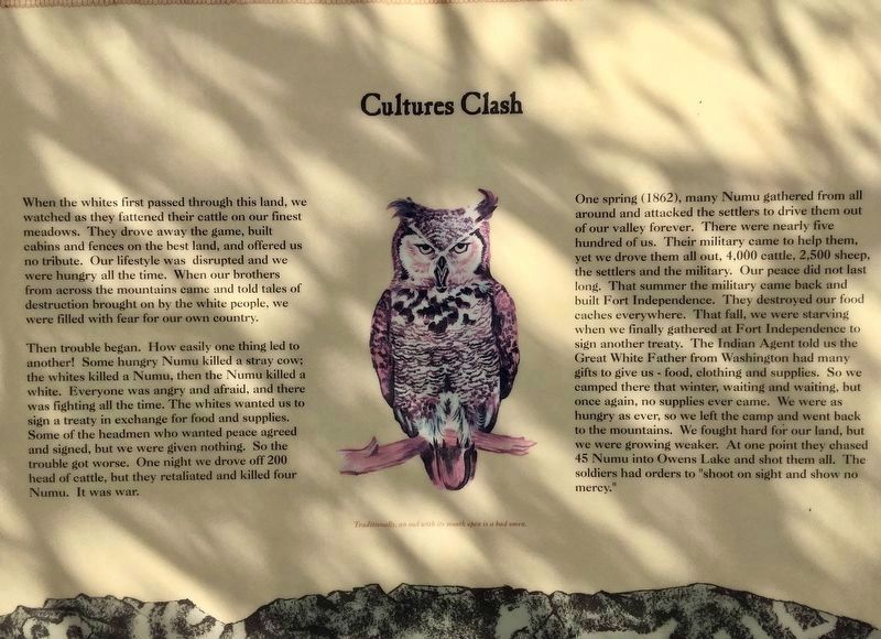
Cultures Clash
201 ► California, Inyo County, Coso Junction — Listen Well, For This Story Must Be Told — Native Americans in the Owens Valley —  |
| On US-395, on the right when traveling north. | |||
| 202 ► California, Inyo County, Independence — Historic Independence — |
| On Edwards Street (U.S. 395) at Inyo Street, on the left when traveling north on Edwards Street. | |||
| 203 ► California, Lake County, Upper Lake — Bloody Island — |
| On Reclamation Road near Redbud Lane, on the right when traveling west. | |||
| 204 ► California, Lassen County, Janesville — 758 — Fort Janesville — |
| On Main Street near South Church Street, on the right when traveling south. | |||
| 205 ► California, Lassen County, Susanville — 565 — Peter Lassen Grave — |
| Near Wingfield Road 1.7 miles south of Richmond Road, on the left when traveling south. | |||
| 206 ► California, Los Angeles County, Los Angeles, South Los Angeles — Patriotic Hall — |
| On Figueroa Street at 18th Street, on the left when traveling south on Figueroa Street. | |||
| 207 ► California, Marin County, Tiburon — Camp Reynolds — |
| Near Camp Reynolds. | |||
| 208 ► California, Mariposa County, El Portal — 527 — Site of Savage’s Trading Post — |
| On CA Highway 140, on the right when traveling east. | |||
| 209 ► California, Mariposa County, Wawona — 4 — Yosemite Valley's First Visit by White Men |
| Near Wawona Road (State Highway 41), on the left when traveling east. Reported missing. | |||
| 210 ► California, Modoc County, Canby — 125 — Evans and Bailey Fight 1861 — |
| On Centerville Road (County Route 54), on the right when traveling east. | |||
| 211 ► California, Modoc County, Copic — 108 — Battle of Land's Ranch — California Historical Landmark — |
| On California Route 139 12 miles south of Tule Lake, on the right when traveling north. | |||
| 212 ► California, Modoc County, Newell — A-44 — Applegate Trail - Bloody Point — California Historical Landmark No. 8 — California Trail — |
| On Old Alturas Highway (County Route 114) 1.1 miles north of County Route 101, on the left when traveling north. | |||
| 213 ► California, Modoc County, Newell — Battle of Dry Lake Memorial — |
| On California Route 139, on the left when traveling north. | |||
| 214 ► California, Modoc County, Newell — 110 — Canby’s Cross — |
| On California Route 139, 0.2 miles Glendale Street, on the right when traveling south. | |||
| 215 ► California, Modoc County, Newell — 9 — Captain Jack’s Stronghold — ← 11 Miles — |
| On State Highway 139, 0.2 miles south of Glendale Street, on the right when traveling south. | |||
| 216 ► California, Modoc County, Newell — Warm Springs Indians — |
| On California Route 139 near County Route 122, on the left when traveling north. | |||
| 217 ► California, Sacramento County, Elk Grove — Alexander Hamilton Willard — 1777-1865 — |
| On Franklin Boulevard at Hood Franklin Road, on the left when traveling north on Franklin Boulevard. | |||
| 218 ► California, Sacramento County, Sacramento, Southwestern Sacramento — Colonel William Stephen Hamilton — In Memory of the Rough Diamond |
| Near Riverside Boulevard. Reported missing. | |||
| 219 ► California, Sacramento County, Sacramento, Southwestern Sacramento — General George Wright — 1803 – 1865 — |
| Near 10th Street, on the right when traveling east. | |||
| 220 ► California, San Joaquin County, Ripon — 214 — Estanislao's Stronghold — |
| Near South Austin Road near Austin Road, on the left when traveling south. | |||
| 221 ► California, Shasta County, Castella — 116 — Battle Rock — |
| On Castle Creek Road, on the left when traveling west. | |||
| 222 ► California, Shasta County, Fall River Mills — Captain Dick and Richard Pugh — |
| On McArthur Road (Route A19) south of Soldier Mountain Road, on the right when traveling north. | |||
| 223 ► California, Sierra County, Downieville — Mountain Howitzers — |
| On Galloway Street. | |||
| 224 ► California, Siskiyou County, Hornbrook — Bradford Ripley Alden — 1811-1870 — |
| On Copco Road at Oregon Road, on the left when traveling east on Copco Road. | |||
| 225 ► California, Siskiyou County, Tule Lake — Ambush at Midday - The Thomas-Wright Battle of April 26, 1873 — Last Victor for the Modocs — |
| Near Hill Road (Route 10) near County Route 120, on the left when traveling south. | |||
| 226 ► California, Siskiyou County, Tule Lake — Attack at Hospital Rock — Lava Beds National Monument — National Park Service, U.S. Department of the Interior — |
| Near County Route 120 near Wildlife Refuge Tour Road, on the right when traveling west. | |||
| 227 ► California, Siskiyou County, Tule Lake — Canby Cross — |
| Near County Route 120 near Hill Road (County Route 10), on the right when traveling east. | |||
| 228 ► California, Siskiyou County, Tule Lake — Shore of Tule Lake — |
| Near County Route 120 near Hill Road (County Route 10), on the left when traveling west. | |||
| 229 ► California, Siskiyou County, Tule Lake — The Road to the Stronghold — |
| On County Route 120 near Hill Road (County Route 10), on the left when traveling west. | |||
| 230 ► California, Siskiyou County, Tulelake — Attracted to Water — Lava Beds National Monument — National Park Service, U.S. Department of the Interior — |
| Near Hill Road, on the left when traveling south. | |||
| 231 ► California, Siskiyou County, Tulelake — Last Meeting of the Peace Commission — Lava Beds National Monument — National Park Service, U.S. Department of the Interior — |
| On Hill Road. | |||
| 232 ► California, Siskiyou County, Tulelake — Lava Fortress — Captain Jack's Stronghold — |
| Near Monument Rim Road. | |||
| 233 ► California, Siskiyou County, Tulelake — Modoc War Casualties — Gillems Graveyard — |
| Near Hill Road (County Road 10). | |||
| 234 ► California, Siskiyou County, Tulelake — The End of the Modoc War — Lava Beds National Monument — |
| On Hill Road (County Road 10), on the left when traveling south. | |||
| 235 ► California, Siskiyou County, Tulelake — 13 — War in the Lava Beds — November 1872 - June 1873 — |
| Near Volcanic Legacy Scenic Byway, on the right when traveling south. | |||
| 236 ► California, Tulare County, Springville — Battle Mountain — |
| On Balch Park Road 12 miles east of CA-190 ( Highway 190), on the right when traveling east. | |||
| 237 ► California, Tulare County, Visalia — Camp Babbitt — |
| On North Santa Fe Street south of East Race Avenue, on the right when traveling south. | |||
| 238 ► California, Tuolumne County, Dardanelle — The Last Battle — |
| Near Mono Way (California Route 108) 15.2 miles east of Herring Creek Lane. | |||
| 239 ► Colorado, Archuleta County, Chama — Cumbres Pass — |
| On State Highway 17 3 miles north of County Road 445, on the right when traveling north. | |||
| 240 ► Colorado, Bent County, McClave — Fort Bent — |
| Near County Road 35.25 south of 5th Street (County Road JJ), on the right when traveling south. | |||
| 241 ► Colorado, Costilla County, Fort Garland — 190 — Fort Garland / Buffalo Soldiers — |
| Near State Highway 159, on the right when traveling south. | |||
| 242 ► Colorado, Denver County, Denver, Central — Colorado Soldier's Monument |
| On Sherman Street. Reported unreadable. | |||
| 243 ► Colorado, Denver County, Denver, Central — 280 — Sand Creek Massacre — and Mile High Marker — |
| On Colfax Avenue. | |||
| 244 ► Colorado, Denver County, Denver, Central — Silas S. Soule — |
| Near 15th Street near Arapahoe Street, on the right when traveling west. | |||
| 245 ► Colorado, Denver County, Denver, Lincoln Park — Camp Weld — |
| On West 8th Avenue at Vallejo Street, on the left when traveling east on West 8th Avenue. | |||
| 246 ► Colorado, Denver County, Denver, Union Station — Cheyenne Dog Soldiers — Indian Wars on the Colorado Plains — |
| On Little Raven Street at 16th Street, on the right when traveling south on Little Raven Street. | |||
| 247 ► Colorado, Denver County, Denver, Union Station — Little Raven — Peace Chief of the Southern Arapahoe — |
| On Little Raven Street at 16th Street on Little Raven Street. | |||
| 248 ► Colorado, El Paso County, Colorado Springs — Buffalo Soldiers Community Memorial — Buffalo Soldiers Historical Snapshot — |
| Near Memorial Drive, on the right when traveling south. | |||
| 249 ► Colorado, Elbert County, Kiowa — Pioneer Women of Colorado — |
| On Colorado Street (State Highway 86). | |||
| 250 ► Colorado, Elbert County, Kiowa — 272 — Trail Under Siege / Rising to the Challenge — |
| On Colorado Street (County Road 86) west of Pawnee Street, on the right when traveling west. | |||
| 251 ► Colorado, Grand County, Fraser — Frontier Infantry — |
| Near Zerex Street (U.S. 40) at Clayton Avenue, on the right when traveling north. | |||
| 252 ► Colorado, Hinsdale County, Lake City — Ute Homeland — |
| On County Highway 2 at County Highway 20, on the left when traveling north on County Highway 2. | |||
| 253 ► Colorado, Jefferson County, Golden — Native Americans on Clear Creek — |
| On Washington Avenue Bridge, on the right when traveling north. | |||
| 254 ► Colorado, Jefferson County, Golden, Lakota Hills — Buffalo Bill — |
| Near Lookout Mountain Road (Lariat Loop). | |||
| 255 ► Colorado, Kiowa County, Chivington — A Chief’s Village — Sand Creek Massacre National Historic Site — |
| Near County Highway W east of Chief White Antelope Way. | |||
| 256 ► Colorado, Kiowa County, Chivington — An End to the Slaughter — Sand Creek Massacre National Historic Site — |
| Near County Highway W east of Chief White Antelope Way. | |||
| 257 ► Colorado, Kiowa County, Chivington — Attack and Pursuit — Sand Creek Massacre National Historic Site — |
| Near County Highway W east of Chief White Antelope Way. | |||
| 258 ► Colorado, Kiowa County, Chivington — Chaos, Disorder, and Disgust — Sand Creek Massacre National Historic Site — |
| Near County Highway W east of Chief White Antelope Way. | |||
| 259 ► Colorado, Kiowa County, Chivington — Cheyenne and Arapaho Village at Sand Creek — Sand Creek Massacre National Historic Site — |
| Near County Highway W east of Chief White Antelope Way. | |||
| 260 ► Colorado, Kiowa County, Chivington — Conflict Within and Without — Sand Creek Massacre National Historic Site — |
| Near County Highway W east of Chief White Antelope Way. | |||
| 261 ► Colorado, Kiowa County, Chivington — Conscience and Courage — Sand Creek Massacre National Historic Site — |
| Near County Highway W west of County Road 56. | |||
| 262 ► Colorado, Kiowa County, Chivington — Dawn November 29, 1864 — Sand Creek Massacre National Historic Site — |
| Near County Highway W east of Chief White Antelope Way. | |||
| 263 ► Colorado, Kiowa County, Chivington — Healing — Sand Creek Massacre National Historic Site |
| Near County Road W 1.3 miles east of County Road 54. Reported permanently removed. | |||
| 264 ► Colorado, Kiowa County, Chivington — Incredible Feats of Bravery — Sand Creek Massacre National Historic Site — |
| Near County Highway W east of Chief White Antelope Way. | |||
| 265 ► Colorado, Kiowa County, Chivington — Incriminations and Culpability — Sand Creek Massacre National Historic Site — |
| Near County Highway W east of Chief White Antelope Way. | |||
| 266 ► Colorado, Kiowa County, Chivington — Past, Present, and Future Come Together — Sand Creek Massacre National Historic Site — |
| Near County Highway W east of Chief White Antelope Way. | |||
| 267 ► Colorado, Kiowa County, Chivington — Pleas for Peace — Sand Creek Massacre National Historic Site |
| Near County Road W 1.3 miles east of County Road 54. Reported permanently removed. | |||
| 268 ► Colorado, Kiowa County, Chivington — Remains — Sand Creek Massacre National Historic Site |
| Near County Road W 1.3 miles east of County Road 54. Reported permanently removed. | |||
| 269 ► Colorado, Kiowa County, Chivington — Returned to Sand Creek — Sand Creek Massacre National Historic Site |
| Near County Highway W just east of Chief White Antelope Way. Reported permanently removed. | |||
| 270 ► Colorado, Kiowa County, Chivington — Sacred Memory — Sand Creek Massacre National Historic Site — |
| Near County Highway W east of Chief White Antelope Way. | |||
| 271 ► Colorado, Kiowa County, Chivington — Testimony — Sand Creek Massacre National Historic Site |
| Near County Road W 1.3 miles east of County Road 54. Reported permanently removed. | |||
| 272 ► Colorado, Kiowa County, Chivington — The Attack |
| Near County Road W 1.3 miles east of County Road 54. Reported permanently removed. | |||
| 273 ► Colorado, Kiowa County, Chivington — The Big Head Fight — Sand Creek Massacre National Historic Site — |
| Near County Highway W east of Chief White Antelope Way. | |||
| 274 ► Colorado, Kiowa County, Chivington — The Sand Creek Massacre — Sand Creek Massacre National Historic Site |
| Near County Road W 1.3 miles east of County Road 54. Reported permanently removed. | |||
| 275 ► Colorado, Kiowa County, Chivington — Troops Approach the Village — Sand Creek Massacre National Historic Site — |
| Near County Road W east of Chief White Antelope Way. | |||
| 276 ► Colorado, Kiowa County, Chivington — Welcome to the Sand Creek Massacre National Historic Site — Sand Creek Massacre National Historic Site — National Park Service, U.S. Department of the Interior — |
| On Unnamed entrance road north of County Road W, in the median. | |||
| 277 ► Colorado, Kiowa County, Chivington — Why A 33 Star Flag — Sand Creek Massacre National Historic Site — |
| Near County Road W east of Chief White Antelope Way. | |||
| 278 ► Colorado, Kiowa County, Chivington — Why? — Sand Creek Massacre National Historic Site — National Park Service, U.S. Department of the Interior |
| On County Road W 1.3 miles east of County Road 54. Reported permanently removed. | |||
| 279 ► Colorado, Kiowa County, Eads — Eads Roadside Park Exhibit — |
| Near E 15th Street (U.S. 287) 0.1 miles east of Maine Street, on the left when traveling east. | |||
| 280 ► Colorado, La Plata County, Durango — Baker's Bridge — |
| On County Highway 250 0.5 miles east of U.S. 550, on the left when traveling east. | |||
| 281 ► Colorado, Lincoln County, Hugo — Hugo Country — |
| Near 4th Street (U.S. 287) west of 7th Avenue, on the right when traveling west. | |||
| 282 ► Colorado, Logan County, Merino — 2 — Fort Wicked — |
| On Grand Army of the Republic Highway (State Highway 6) at County Road 2.5, on the right when traveling east on Grand Army of the Republic Highway. | |||
| 283 ► Colorado, Logan County, Sterling — 34 — Battle of Summit Springs — |
| On Colorado Route 63 north of County Road 16, on the left when traveling north. | |||
| 284 ► Colorado, Logan County, Sterling — 227 — Indian Wars 1864-1869 — |
| On County Road 370 near U.S. 6. | |||
| 285 ► Colorado, Montrose County, Montrose — Fort Crawford — |
| On US 550 Frontage Road just south of Uncompahgre Road, on the right when traveling south. | |||
| 286 ► Colorado, Montrose County, Montrose — Fort Crawford — The Cantonment on the Uncompahgre — |
| On US 550 Frontage Road just south of Uncompahgre Road, on the right when traveling south. | |||
| 287 ► Colorado, Prowers County, Lamar — Experience the Past on the Santa Fe Trail — |
| Near Main Street (U.S. 50) at E. Beech Street, on the right when traveling north. | |||
| 288 ► Colorado, Prowers County, Wiley — Why a Massacre? — |
| Near County Highway 35.25 south of County Highway JJ. | |||
| 289 ► Colorado, Rio Blanco County, Meeker — Founding of Meeker — |
| Near Main Street at 6th Street, on the right when traveling west. | |||
| 290 ► Colorado, Rio Blanco County, Meeker — History of Meeker & the White River Valley — |
| On Main Street at 6th Street, on the right when traveling west on Main Street. | |||
| 291 ► Colorado, Rio Blanco County, Meeker — Nathan C. Meeker — United States Indian Agent — |
| On Colorado Route 64 2 miles west of Loop Highway 13, on the left when traveling west. | |||
| 292 ► Colorado, Rio Blanco County, Meeker — 1993 — Ute Indians at the Battle of Milk Creek — |
| On County Road 15 (County Route 15) north of County Route 51, on the left. | |||
| 293 ► Colorado, Washington County, Akron — Indian Wars 1864-1869 — |
| On West 1st Street (U.S. 34) at Custer Avenue, on the left when traveling west on West 1st Street. | |||
| 294 ► Colorado, Yuma County, Wray — Buffalo Soldiers to the Rescue — |
| Near County Road KK south of County Road 20.7. | |||
| 295 ► Colorado, Yuma County, Yuma — Battle of Beecher Island — |
| On U.S. 34 at County Highway J, on the right when traveling west on U.S. 34. | |||
| 296 ► Connecticut, Capitol Region, Windsor — Major John Mason — |
| On Palisado Avenue (Connecticut Route 159) at North Meadow Road, on the right when traveling north on Palisado Avenue. | |||
| 297 ► Connecticut, Lower Connecticut River Valley Region, Old Saybrook, Old Saybrook Center — Welcome to Fort Saybrook Monument Park — |
| On College Street east of Bridge Street ( Route 154) when traveling west. | |||
| 298 ► Connecticut, Northeastern Region, Brooklyn, Pomfret Center — Israel Putnam's First Home — |
| On Route 169, on the right when traveling south. | |||
| 299 ► Connecticut, South Central Region, Milford — George W. Baird — |
| Near Gulf Street at Cherry Street, on the right when traveling south. | |||
| 300 ► Connecticut, Southeastern Region, Groton, Mystic — Historic Mystic, Connecticut — |
| On Jewish War Veterans Memorial Highway (Interstate 95) 0.5 miles east of Mystic Street ( Route 614), on the right when traveling east. | |||
3301 entries matched your criteria. Entries 201 through 300 are listed above. ⊲ Previous 100 — Next 100 ⊳