116 entries match your criteria. The first 100 are listed. ⊳
Acadian History Historical Markers
Markers, regardless of organization, commemorating Acadian culture and history as found in France, New France, the Canadian Maritimes, Maine, Louisiana and elsewhere.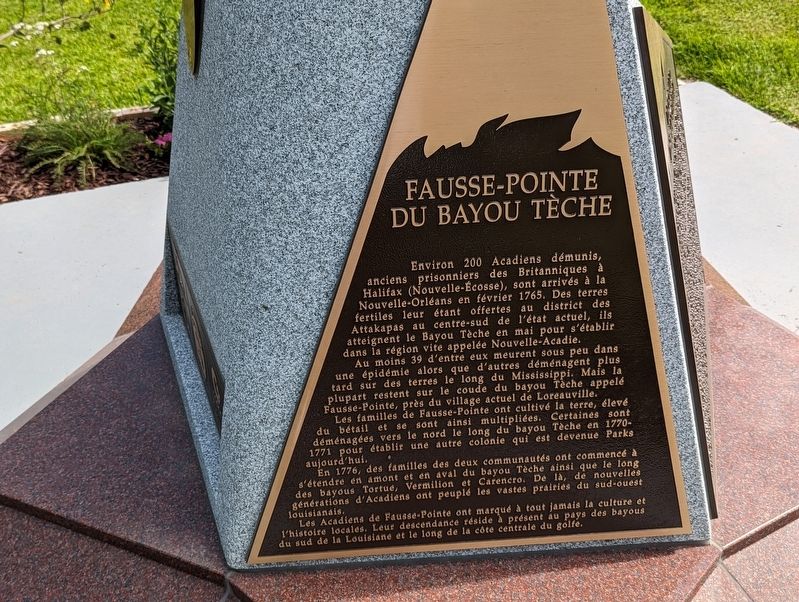
By Cajun Scrambler, July 14, 2023
Fausse=Pointe du Bayou Tèche side of marker
| 1 ► Louisiana, Iberia Parish, Loreauville — Fausse Point of Bayou Teche / Fausse-Pointe du Bayou Tèche — |
| On Bridge Street (State Highway 344) near South Main Street (Route 86). | |||
| 2 ► Louisiana, Iberia Parish, Loreauville — New Acadia / Nouvelle Acadie — |
| On Bridge Street (State Highway 344) 0.2 miles west of Main Street (Highway 86), on the left when traveling west. | |||
| 3 ► Louisiana, Iberia Parish, Loreauville — The Grand Dérangement / Le Grand Dérangement — |
| On Bridge Street (Route 344) 0.2 miles west of Main Street (Route 86), on the left when traveling west. | |||
| 4 ► Louisiana, Lafayette Parish, Lafayette — Vermilionville Historical Timeline — pre-1699 - 1800 — |
| Near Fisher Road near Surrey Street (State Road 728-8). | |||
| 5 ► Louisiana, Lafayette Parish, Lafayette — Vermilionville Historical Timeline — 1775-1920 — |
| Near Fisher Road near Surrey Street (State Road 728-8). | |||
| 6 ► Louisiana, St. James Parish, St. James — Site of First Acadian Settlers in Louisiana — |
| On River Rd. (State Highway 18) 0.2 miles south of Dept. Of Energy Rd., on the left when traveling south. | |||
| 7 ► Louisiana, St. Martin Parish, St. Martinville — Deportation Cross — Le Croix de la Déportation — |
| Near South New Market Street south of East Bridge Street (Highway 96), on the left when traveling south. | |||
| 8 ► Louisiana, Terrebonne Parish, Houma — New Acadia / Nouvelle Acadie — |
| On West Park Avenue (State Highway 24) north of Barrow Street (State Highway 182), on the left when traveling north. | |||
| 9 ► Louisiana, Terrebonne Parish, Houma — The Grand Dérangement / Le Grand Dérangement — |
| On West Park Avenue (State Highway 24) north of Barrow Street (State Highway 182), on the right when traveling north. | |||
| 10 ► Louisiana, Terrebonne Parish, Houma — The Great Acadian Upheaval — Exiled Acadians become Louisiana's Cajuns — |
| Near West Park Avenue (State Highway 24) north of Barrow Street (State Highway 182), on the right when traveling north. | |||
| 11 ► Maine, Hancock County, Bar Harbor — The French Connection — Acadia National Park — |
| On Paradise Hill Road, on the left when traveling south. | |||
| 12 ► New Brunswick, Albert County, Hillsborough — Combat of the/du Petitcodiac — |
| On Main Street (New Brunswick Route 114) just south of Legion Street, on the left when traveling south. | |||
| 13 ► New Brunswick, Carleton County, Hartland — St. John River — |
| Near Main Street (Route 105) north of Hartland Hill Bridge Road, on the right when traveling south. | |||
| 14 ► New Brunswick, Charlotte County, Bayside — A French Colony in Acadie / Une colonie française en Acadie — |
| Near New Brunswick Route 127, 9 kilometers south of New Brunswick Route 1, on the right when traveling south. | |||
| 15 ► New Brunswick, Charlotte County, Bayside — A Place to Settle / Un endroit où s’établir — |
| Near New Brunswick Route 127, 9 kilometers south of New Brunswick Route 1, on the right when traveling south. | |||
| 16 ► New Brunswick, Charlotte County, Bayside — A Winter of Despair / Un hiver de désespoir — |
| Near New Brunswick Route 127, 9 kilometers south of New Brunswick Route 1, on the right when traveling south. | |||
| 17 ► New Brunswick, Charlotte County, Bayside — In Champlain’s Footsteps / Sur les traces de Champlain — |
| Near New Brunswick Route 127, 9 kilometers south of New Brunswick Route 1, on the right when traveling south. | |||
| 18 ► New Brunswick, Charlotte County, Bayside — Moving on / Le déménagement — |
| Near New Brunswick Route 127, 9 kilometers south of New Brunswick Route 1, on the right when traveling south. | |||
| 19 ► New Brunswick, Charlotte County, Bayside — Saint Croix Island International Historic Site / Lieu historique international de l'Île Sainte-Croix — |
| Near New Brunswick Route 127, 9 kilometers south of New Brunswick Route 1, on the right when traveling south. | |||
| 20 ► New Brunswick, Charlotte County, Bayside — The River Flows On... / La rivière poursuit son cours... — |
| Near New Brunswick Route 127, 9 kilometers south of New Brunswick Route 1, on the right when traveling south. | |||
| 21 ► New Brunswick, Charlotte County, Bayside — Where Two Worlds Met / Rencontre de deux mondes — |
| Near New Brunswick Route 127, 9 kilometers south of New Brunswick Route 1, on the right when traveling south. | |||
| 22 ► New Brunswick, Charlotte County, St. Andrews — St. Croix River — La Rivière Sainte-Croix — |
| Near Water Street close to King Street, on the right when traveling east. | |||
| 23 ► New Brunswick, Gloucester County, Caraquet — Le Grand Dérangement — Caraquet — |
| Near West St. Peter Boulevard (New Brunswick Route 11) close to Sainte Ann Street North, on the left when traveling east. | |||
| 24 ► New Brunswick, Gloucester County, Caraquet — The Return of the Acadians — Le retour des Acadiens — |
| On West St. Peter Boulevard (New Brunswick Route 11) near Sainte Ann Street North, on the left when traveling east. | |||
| 25 ► New Brunswick, Kent County, Cocagne — Cocagne — 1767-2017 — |
| On New Brunswick Route 134 just north of Chemin Lovers Lane, on the right when traveling north. | |||
| 26 ► New Brunswick, Kent County, Saint-Antoine — Louis J. Robichaud — 1925-2005 — |
| Near Rue Principale (Route 115) south of Rue Edouard, on the left when traveling south. | |||
| 27 ► New Brunswick, Kent County, Saint-Louis-de-Kent — Marcel-François Richard — (1847-1915) — |
| On Rue Principale (Main Street) (New Brunswick Route 134) at Chemin Desherbiers (Desherbiers Road), on the right when traveling south on Rue Principale (Main Street). | |||
| 28 ► New Brunswick, Victoria County, Grand Falls — Acadia of the Lands and Forests / l'Acadie des terres et forêts — |
| On Broadway Boulevard at Church Street, in the median on Broadway Boulevard. | |||
| 29 ► New Brunswick, Westmorland County, Dieppe — Les Acadiens / The Acadians — Riviére Petitcodiac River — |
| Near Champlain Street (New Brunswick Route 106) 0.1 kilometers east of Wheeler Boulevard, on the right when traveling east. | |||
| 30 ► New Brunswick, Westmorland County, Dieppe — The Grand Dérangement — Resistance on the Petcoudiac / La Résistance sur la Petcoudiac — |
| Near Champlain Street (New Brunswick Route 106) 0.1 kilometers east of Wheeler Boulevard, on the right when traveling east. | |||
| 31 ► New Brunswick, Westmorland County, Dorchester — 400th Anniversary of 1st Acadian Settlement — |
| On Main Street (New Brunswick Route 106) just north of Woodlawn Road, on the right when traveling north. | |||
| 32 ► New Brunswick, Westmorland County, Moncton — First Settlers / Premiers Colons — |
| On Main Street (New Brunswick Route 106) at Bendview Court, on the right when traveling east on Main Street. | |||
| 33 ► Nova Scotia, Annapolis County, Annapolis Royal — Acadian Dykeland — Les terres endiguées des Acadiens — |
| Near St. George Street close to St. Anthony Street, on the left when traveling west. | |||
| 34 ► Nova Scotia, Annapolis County, Annapolis Royal — Annapolis Royal Historic District — L’arrondissement historique d’Annapolis Royal — |
| On St. George Street close to St. James Street, on the left when traveling north. | |||
| 35 ► Nova Scotia, Annapolis County, Annapolis Royal — Cemeteries — Les Cimetières — |
| Near St. George Street close to St. Anthony Street, on the left when traveling west. | |||
| 36 ► Nova Scotia, Annapolis County, Annapolis Royal — Charles Fort / Le fort Charles — Charles de Menou d’Aulnay — (ca. 1604-1650) / (v.1604-1650) — |
| Near St. George Street close to St. Anthony Street, on the left when traveling west. | |||
| 37 ► Nova Scotia, Annapolis County, Annapolis Royal — Daniel Auger de Subercase — |
| Near St. George Street at St. Anthony Street, on the left when traveling east. | |||
| 38 ► Nova Scotia, Annapolis County, Annapolis Royal — Duvivier Attack — L’attaque de Duvivier — |
| Near St. George Street close to St. Anthony Street, on the left when traveling west. | |||
| 39 ► Nova Scotia, Annapolis County, Annapolis Royal — Jean Paul Mascarene — c. 1694-1760 — |
| Near St. George Street close to St. Anthony Street, on the left when traveling west. | |||
| 40 ► Nova Scotia, Annapolis County, Annapolis Royal — Port-Royal — |
| Near St. George Street close to St. Anthony Street, on the left when traveling west. | |||
| 41 ► Nova Scotia, Annapolis County, Annapolis Royal — Sieur de Monts — |
| Near St. George Street close to St. Anthony Street, on the left. | |||
| 42 ► Nova Scotia, Annapolis County, Annapolis Royal — The Black Hole / Le cachot — |
| Near St. George Street close to St. Anthony Street, on the left when traveling west. | |||
| 43 ► Nova Scotia, Annapolis County, Annapolis Royal — The Flag Bastion — Le bastion de l’étendard — |
| Near St. George Street close to St. Anthony Street, on the left when traveling west. | |||
| 44 ► Nova Scotia, Annapolis County, Annapolis Royal — Wharf & Waterfront — Historic Lower Saint George Street — |
| On St. George Street at Drury Lane, on the right when traveling north on St. George Street. | |||
| 45 ► Nova Scotia, Cape Breton Region, Louisbourg — Fortress of Louisbourg — La forteresse de Louisbourg — |
| Near Kennington Cove Road. | |||
| 46 ► Nova Scotia, Cape Breton Region, Louisbourg — French Garrison at Louisbourg — |
| Near Havenside Road, on the left when traveling east. | |||
| 47 ► Nova Scotia, Cape Breton Region, Louisbourg — French Naval Guns — |
| On Main Street close to Huntington Avenue, on the left when traveling east. | |||
| 48 ► Nova Scotia, Cape Breton Region, Louisbourg — Lighthouse Point — La pointe du phare — |
| On Havenside Road, on the right when traveling east. | |||
| 49 ► Nova Scotia, Cape Breton Region, Louisbourg — Louisbourg Harbour — Le port de Louisbourg — |
| On Havenside Road, on the left when traveling east. | |||
| 50 ► Nova Scotia, Cape Breton Region, Louisbourg — Marie Marguerite Rose — (1717-1757) — |
| 51 ► Nova Scotia, Cape Breton Region, Louisbourg — Slavery / Freedom — Esclavage / Liberté — |
| 52 ► Nova Scotia, Cape Breton Region, Louisbourg — The Lobster Fishery — Le pêche du homard — |
| On Havenside Road, on the left when traveling east. | |||
| 53 ► Nova Scotia, Cape Breton Region, Louisbourg — The Siege Landing — Débarquement des assiégeants — |
| On Kennington Cove Road, on the left when traveling west. | |||
| 54 ► Nova Scotia, Cape Breton Region, Louisbourg — Wolfe’s Landing — Le débarquement de Wolfe — |
| Near Kennington Cove Road. | |||
| 55 ► Nova Scotia, Cape Breton Region, Port Morien — L'industrie du Charbon au Canada / Canada's Coal Industry — |
| On Long Beach Road, 1 kilometer north of Marconi Trail (Route 255), on the left when traveling north. | |||
| 56 ► Nova Scotia, Cape Breton Region, Port Morien — The First Coal Workings in North America — |
| On Long Beach Road north of Marconi Trail (Route 255), on the right when traveling north. | |||
| 57 ► Nova Scotia, Colchester County, Debert — Isgonish-French River Portage — |
| On Glooscap Trail (National Route 2) 0.5 kilometers west of Belmont Road/Fort Belcher Road, on the right when traveling west. | |||
| 58 ► Nova Scotia, Colchester County, Lower Truro — First Landing — |
| On Tidal Bore Road, 0.6 kilometers north of Glooscap Trail (Nova Scotia Route 236), on the left when traveling north. | |||
| 59 ► Nova Scotia, Colchester County, Tatamagouche — Naval Encounter at Tatamagouche — (15th June, 1745) — |
| On Main Street (Nova Scotia Route 6) at Church Street, on the left when traveling west on Main Street. | |||
| 60 ► Nova Scotia, Cumberland County, Fort Lawrence — Beaubassin — |
| 61 ► Nova Scotia, Cumberland County, Fort Lawrence — Beaubassin 1672-1750 — |
| 62 ► Nova Scotia, Cumberland County, Fort Lawrence — Early Inhabitants — |
| 63 ► Nova Scotia, Cumberland County, Fort Lawrence — Fort Lawrence and English Settlement — |
| 64 ► Nova Scotia, Cumberland County, Fort Lawrence — Un hommage à/A Tribute to Jacob (Jacques) Bourgeois — |
| 65 ► Nova Scotia, Guysborough County, Canso — Canso — |
| On School Street, on the right when traveling east. | |||
| 66 ► Nova Scotia, Guysborough County, Canso — The Canso Islands/ Les îles Canso — |
| Near Water Street. | |||
| 67 ► Nova Scotia, Guysborough County, Canso — Where Fishermen Meet / Lieu de rencontre des pêcheurs — |
| Near Water Street. | |||
| 68 ► Nova Scotia, Guysborough County, Larrys River — 4 — Acadian Dyke Building Along the Bay of Fundy — Construction de digues le long de la Baie de Fundy — |
| On Marine Drive (Nova Scotia Route 316) at Ballfield Loop, on the right when traveling west on Marine Drive. | |||
| 69 ► Nova Scotia, Guysborough County, Larrys River — 9 — Chezzetcook, Tracadie and Havre Boucher — |
| On Marine Drive (Nova Scotia Route 316) at Ballfield Loop, on the right when traveling west on Marine Drive. | |||
| 70 ► Nova Scotia, Guysborough County, Larrys River — Founding Families of the Acadian Communities Along Tor Bay 1797-1900 — Familles fondatrices Acadiennes dela Région de Tor Baie 1797-1900 — |
| On Marine Drive (Nova Scotia Route 316) at Ballfield Loop, on the right when traveling west on Marine Drive. | |||
| 71 ► Nova Scotia, Guysborough County, Larrys River — 1 — French Expeditions Aimed At Settling North America — Expéditions françaises destinées à s'établir en Amérique du Nord — |
| On Marine Drive (Nova Scotia Route 316) at Ballfield Loop, on the right when traveling west on Marine Drive. | |||
| 72 ► Nova Scotia, Guysborough County, Larrys River — 5 — Grand-Pré — |
| On Marine Drive (Nova Scotia Route 316) at Ballfield Loop, on the right when traveling west on Marine Drive. | |||
| 73 ► Nova Scotia, Guysborough County, Larrys River — Le Parc de nos Ancêtres — The Park of Our Ancestors — |
| On Marine Drive (Nova Scotia Route 316) at Ballfield Loop, on the right when traveling west on Marine Drive. | |||
| 74 ► Nova Scotia, Guysborough County, Larrys River — 3 — Samuel de Champlain Meets Captain Savalette On Shores of Tor Bay — Champlain rencontre le Capitaine Savalette sur les Côtes de Tor Baie — |
| On Marine Drive (Nova Scotia Route 316) at Ballfield Loop, on the right when traveling west on Marine Drive. | |||
| 75 ► Nova Scotia, Guysborough County, Larrys River — 2 — Settlement of l’Acadie 1604/1605 — L’établissement de l’Acadie, 1604/1605 — |
| On Marine Drive (Nova Scotia Route 316) at Ballfield Loop, on the right when traveling west on Marine Drive. | |||
| 76 ► Nova Scotia, Guysborough County, Larrys River — 10 — Settlement of the Tor Bay Area circa 1797 — |
| On Marine Drive (Nova Scotia Route 316) at Ballfield Loop, on the right when traveling west on Marine Drive. | |||
| 77 ► Nova Scotia, Guysborough County, Larrys River — 6 — The Great Upheaval 1755-1763 — Le grand dérangement — |
| On Marine Drive (Nova Scotia Route 316) at Ballfield Loop on Marine Drive. | |||
| 78 ► Nova Scotia, Guysborough County, Larrys River — 8 — The Resettlement — Rétablissement — |
| On Marine Drive (Nova Scotia Route 316) at Ballfield Loop, on the right when traveling west on Marine Drive. | |||
| 79 ► Nova Scotia, Guysborough County, Larrys River — 7 — The Scattering of a People — La dispersion d’un peuple — |
| On Marine Drive (Nova Scotia Route 316) at Ballfield Loop, on the right when traveling west on Marine Drive. | |||
| 80 ► Nova Scotia, Guysborough County, Port Felix — Captain Savalette — |
| On Marine Drive (Nova Scotia Route 316) at Port Felix Loop, on the left when traveling west on Marine Drive. | |||
| 81 ► Nova Scotia, Guysborough County, Port Felix — Welcome to Place Savalette — |
| On Marine Street (Nova Scotia Route 316) at Port Felix Loop, on the left when traveling west on Marine Street. | |||
| 82 ► Nova Scotia, Guysborough County, Whitehead — Port Felix — |
| Near Whitehead Road, on the right when traveling south. | |||
| 83 ► Nova Scotia, Halifax Region, Halifax — Pierre Maillard — |
| On Spring Garden Road close to Barrington Street, on the right when traveling west. | |||
| 84 ► Nova Scotia, Kings County, Grand Pré — Grand Pre Marsh Body — 1760-1995 — |
| On Grand Pré Road at Miner Road, on the right when traveling north on Grand Pré Road. | |||
| 85 ► Nova Scotia, Kings County, Grand Pré — Grand-Pré Rural Historic District — Arrondissement Historique Rurual de Grand-Pré — |
| Near Grand-Pré Road close to Old Post Road, on the left when traveling north. | |||
| 86 ► Nova Scotia, Kings County, Grand Pré — 01 — Statue of Evangeline — La statue d’Évangéline — Longfellow’s Heroine / Héroïne de Longfellow — |
| Near Grand-Pré Road close to Old Post Road, on the left when traveling north. | |||
| 87 ► Nova Scotia, Kings County, Grand Pré — The Attack at Grand Pré/La bataille Grand Pré — |
| On Grand Pré Road at Old Post Road, on the right when traveling north on Grand Pré Road. | |||
| 88 ► Nova Scotia, Kings County, Grand Pré — The Expulsion of the Acadians — La déportation des Acadiens — (1755-1762) — |
| Near Grand-Pré Road close to Old Post Road, on the left when traveling north. | |||
| 89 ► Nova Scotia, Kings County, Grand Pré — The Landscape of Grand Pré/Le Paysage de Grand-Pré — How the Battle Unfolded/Le déroulement de la bataille — |
| On Grand Pré Road at Old Post Road, on the right when traveling north on Grand Pré Road. | |||
| 90 ► Nova Scotia, Kings County, Horton Landing — The Tragedy of the Deportation/La tragédie de la Déportation — |
| Near Wharf Road. | |||
| 91 ► Nova Scotia, Kings County, Hortonville — Horton Landing Cross — |
| Near Wharf Road. | |||
| 92 ► Nova Scotia, Lunenburg County, Lunenburg — Merligueche — |
| On Linden Avenue at Bluenose Drive, on the left when traveling west on Linden Avenue. | |||
| 93 ► Nova Scotia, Lunenburg County, Lunenburg — The Early Acadian History of Lunenburg — L’histoire des premiers Acadiens de Lunenburg — |
| Near Linden Avenue close to Bluenose Drive. | |||
| 94 ► Nova Scotia, Richmond County, St. Peter's — The French Settlement of Saint-Pierre — L’établissement français de Saint-Pierre — |
| On Toulouse Street, on the right when traveling east. | |||
| 95 ► Nova Scotia, Victoria County, Englishtown — Sainte-Anné — |
| On Nova Scotia Route 312, on the right when traveling south. | |||
| 96 ► Nova Scotia, Victoria County, Neil's Harbour — Neil's Harbour — The Cabot Trail — |
| On Lighthouse Road just east of New Haven Road, on the right when traveling east. | |||
| 97 ► Nova Scotia, Yarmouth County, Cape Forchu — Cheboque — |
| 98 ► Nova Scotia, Yarmouth County, Hubbard's Point — Barges de foin salé de Buttes-Amirault — Salt Haystacks of Amirault's Hill — |
| On Nova Scotia Route 308 at Chemin des Gasson, on the right when traveling south on Provincial Route 308. | |||
| 99 ► Nova Scotia, Yarmouth County, Lower West Pubnico — What and When is Le Village Acadien? — Le Village historique acadien, c'est quoi?...c'est quand? — |
| 100 ► Nova Scotia, Yarmouth County, Lower West Pubnico — A Bond with the Sea / A Sustaining Faith — Un lien avec la mer / Une foi nourrissante — |
116 entries matched your criteria. The first 100 are listed above. The final 16 ⊳