Front Plaque
French Statesman
Friend of the American Revolution
“...The new County so to be formed be called Lafayette or Fayette County to perpetuate a remembrance of his virtues and philanthropy through future ages of our . . . — — Map (db m55817) HM
Morris Harvey House
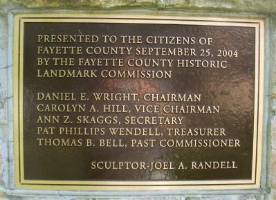
has been placed on the
National Register
of Historic Places
by the United States
Department of the Interior
1902 — — Map (db m204329) HM
The gorge, like all
environments, is continually
changing. Change peaked in
the late 1800s when logging,
mining, and the railroad
converged to play a vital role
in the industrialization of the
United States. By the 1960s,
industrial . . . — — Map (db m165213) HM
New River Gorge Bridge
has been placed on the
National Register of
Historic Places
August 14, 2013
by the United States Department of the Interior — — Map (db m165219) HM
With the opening of the iconic New River Gorge Bridge on October 22, 1977, the challenge of getting
across the 876 foot deep gorge was solved. The bridge dramatically decreased travel time. A 45 minute
winding drive down and back up suddenly . . . — — Map (db m165211) HM
The primary goal of most coal mining companies in New River Gorge was to maximize profits and decrease costs. It was common for coal companies to put physical and social needs of their workers and families last. Safety, health, social service and . . . — — Map (db m179418) HM
John Townsend bought a large tract of land here in 1841, an area that became Lansing, Ames Heights and Canyon Rim Park. Operated a ferry that provided commercial transport across the river at site of present bridge until the civil war. Grandson . . . — — Map (db m78288) HM
Masonic group owned property in 1854. Baptists worshipped here prior to Civil War, but building destroyed during the conflict. Contains 29 marked graves, including town's early settlers and soldiers of the Civil War. A number of graves are marked . . . — — Map (db m76708) HM
Imagine shoveling coal all day while balanced on your knees! In the coal mines of the gorge, the height of the mines corresponded to the height of the coal seam, in some cases just three feet tall. To loosen the coal, explosives were set of at the . . . — — Map (db m179416) HM
When the war began, most residents of this part of present-day West Virginia were Confederate in their sympathies. Both Confederate and Union forces considered the wooden covered bridge here strategically important because the James River and . . . — — Map (db m34373) HM
Christopher Q. Tompkins
Born 1813 in Matthews County, VA.
Tompkins was an 1836 graduate of
West Point. A prominent industrial
businessman in the Kanawha Valley
before the Civil War, from May to
November 1861 he was colonel of
the . . . — — Map (db m138027) HM
Here New and Gauley rivers unite to form Great Kanawha River. Piers still stand of old bridge destroyed by the Confederate troops in 1861. Here Thomas Dunn English, author of the ballad, "Ben Bolt," wrote "Gauley River". — — Map (db m20818) HM
Smoke filled the sky over Gauley Bridge on July 26, 1861, as Confederate Gen. Henry B. Wise's soldiers torched the Kanawha River bridge that stood on the piers directly in front of you. That destruction, however, did not prevent Union Gen. Jacob . . . — — Map (db m242422) HM
Today we stand on a silent battlefield. The smoke of guns long since cooled hangs densely about our feet. Thousands of white crosses honor the noble dead. The wars are over. And the empty echoes of yesterday’s cannons ring dimly in our ears.
. . . — — Map (db m138034) WM
This monument erected in honor of the brave and courageous men and women who have served our country, in time of war and peace, thus helping to preserve freedom for this community, state and great nation of the United States of America and . . . — — Map (db m242420) WM
Located across Kanawha River from this point was Civil War camp for Union Army, 1862-64. Site had 56 cabins and parade grounds for 23rd Ohio Vol. Inf. commanded by Col. Rutherford B. Hayes and Lt. William McKinley, future United States presidents. — — Map (db m50397) HM
From 1909 to 1939, the Bank of Glen Jean provided financial power for the mines, towns, and people along Dunloup
Creek, shaping the lives of many in the New River coal fields. William McKell served as president for the bank's entire
existence . . . — — Map (db m165214) HM
The town of Glen Jean-and a small empire-began as a wedding gift. In 1870, Thomas McKell of Ohio received about 12,500 acres of
West Virginia land from his father-in-law. After geologists confirmed the presence of coal, McKell purchased another . . . — — Map (db m165216) HM
Directly across the street stood the Glen Jean Athletic Club. Alongside it was the ball bark. These, along with tennis and croquet courts, made Glen Jean a center for indoor and outdoor sports.
In New River’s coal towns, baseball was a major . . . — — Map (db m99966) HM
In New River coal towns, baseball was a major part of social life. Fierce competition sometimes prompted coal companies
to hire workers, or pay them more, based upon athletic ability. Glen Jean teams played against other company town teams . . . — — Map (db m167363) HM
The nearby highway is part of route traversing W.Va. from Lewisburg to Point Pleasant memorialized by the state to commemorate the march of the American Colonial army of 1,200 men led by Andrew & Charles Lewis. After a month's march this army . . . — — Map (db m33809) HM
This tight workspace (bench) was carved out of the mountainside to support the movement of mined coal. From 1899 to 1962, thousands of miners and over 16 millions tons of coal passed through these drift mine openings along this edge. With space at a . . . — — Map (db m242497) HM
Driving on Fayette Station Road is like traveling back in time. This one hundred year- old road of hairpin turns was the only way to cross the New River in this area before the New River Gorge Bridge was built in 1977.
New River Gorge National . . . — — Map (db m242425) HM
Kaymoor One Mining Complex (1899 - 1962) stretched the height of the gorge, one of over 80 industrial towns in the gorge during the early 1900s. Big mines like Kaymoor fueled the nation's demand for coal and its byproduct coke, a more efficient . . . — — Map (db m242502) HM
Kaymoor's headhouse stood directly in front of you. This structure was used to start the movement of coal from the mine to the market. A loaded coal car was weighed in the headhouse at the top. Its contents were then dumped into a storage bin in . . . — — Map (db m242501) HM
Remnants of Kaymoor's transportation system, the mountain haulage, are visible beneath this boardwalk. Nearly one mile of cable was used to raise and lower the car that was loaded with supplies or people. By early accounts, the scariest part of . . . — — Map (db m242503) HM
Welcome to Kaymoor Bottom! The structures around you are all that remain of Kaymoor One's coal processing plant (metal remains) and power station (stone/brick walls). The coke ovens and former town are upstream to the right of the boardwalk, running . . . — — Map (db m242504) HM
Kaymoor was one of the largest coal mine complexes in the New River Gorge.
You are at Kaymoor One. Here workers mined over 16 million tons of coal and
processed one million tons of coke between 1899 and 1962.
Kaymoor was a company town, built . . . — — Map (db m165222) HM
Kaymoor was one of the largest coal mine complexes in the New River Gorge. You are two miles from Kaymoor One. Here workers mined over 16 million tons of coal and processed one million tons of coke between 1899 and 1962.
Kaymoor was a company . . . — — Map (db m242426) HM
Getting around at Kaymoor was a challenge. Workers and their families either lived at Kaymoor Top, where you are standing now, or 900 feet
below at Kaymoor Bottom. Company employees either worked in the middle of the gorge (bench) where the coal . . . — — Map (db m165221) HM
Bats play a critical role in the health of ecosystems and human economies worldwide. Globally, bats provide pollination, seed dispersal, and control insect populations. The 10 subterranean bat species of the New River Gorge are insectivores. Many . . . — — Map (db m242499) HM
These stone and brick walls are remains of the fan house used to ventilate Kaymoor One Mine from 1919 to 1928. The confined spaces inside mines required extra ventilation to avoid the buildup of explosive gases and dust. Large fans moved air through . . . — — Map (db m242498) HM
On opposite sides of the New River, the twin mining towns of Fayette and South Fayette were established along the tracks of the Chesapeake & Ohio Railway. The company town of Fayette provided miners with housing, a company store, a school, post . . . — — Map (db m179372) HM
The original Fayette Station Bridge built in 1889 provided a much needed way to reach the other side of the gorge. No longer did people have to take a dangerous and time-consuming ferry to get across the river.
The bridge you are standing on . . . — — Map (db m179369) HM
In the early 1900s, over 80 coal mines and towns lined this gorge and were connected by the Chesapeake & Ohio (C&O) Railway. Freight trains ran every 15 minutes and a dozen passenger trains ran daily during those busy times. The area's industrial . . . — — Map (db m243360) HM
New River coal, the natural resource that created the gorge's boom and bust economy, is the product of a geologic process millions of years in the making.
300 million years ago, the landscape here was a tropical swamp covered with vegetation. . . . — — Map (db m242423) HM
Nine hundred feet below, New River flows north. North? Odd in the American east where rivers don’t flow north. Oddities seem common at New River.
The river’s name and age are both unusual. No one knows the name’s origin: some say explorers found . . . — — Map (db m99982) HM
You may find it hard to believe that the New River Gorge was once teeming with activity. Coal mining dominated the economy and social structure of the state of West Virginia between 1875 and 1950. During this time over forty coal mining towns were . . . — — Map (db m165274) HM
In the early 1900’s, mines and mining towns lined New River Gorge. One such town, Kaymoor, stood in the distance where the river disappears from view. Kaymoor typified New River’s mining era.
For years New River Gorge’s rugged remoteness defied . . . — — Map (db m99988) HM
Completed in 1977, New River Bridge is the world’s longest single-arch steel span bridge. At 876 feet above the river it is American’s 2nd-highest bridge.
Features to Notice Color. The steel used here, Cor-ten steel, rusts slightly on the . . . — — Map (db m99996) HM
When the New River Gorge Bridge
was completed on October 22, 1977,
a travel challenge was solved. The
bridge reduced a 45-minute drive
down narrow mountain roads and
across one of North America's
oldest rivers to less than a minute
drive. . . . — — Map (db m165220) HM
When the New River Gorge Bridge
was completed on October 22, 1977,
a travel challenge was solved. The
bridge reduced a 45-minute drive
down narrow mountain roads and
across one of North America's
oldest rivers to less than a minute
drive. . . . — — Map (db m223789) HM
Notice the tree-covered slopes of the Gorge—they are not as they appear.
From here the solid forest cover from riverbottom to ridgetop all looks pretty much the same, but, a close look reveals great differences. The forest varies with slope, . . . — — Map (db m99980) HM
This walkway leads to views of the New River Bridge. An easily-accessible upper overlook provides a scenic view framed by trees. From there the walkway descends 200 feet down a steep stairway to a broad view of the bridge, gorge, and New River 600 . . . — — Map (db m99993) HM
What is so special here? Why did the United States Congress in 1978 add New River Gorge to America’s system of National Parks? Because at New River Gorge National River there is:
(Inscriptions under the images-left to right, top to bottom) *An . . . — — Map (db m99975) HM
Site of largest mine disaster in Fayette County history. On 2 March 1915, coal dust in Layland #3 ignited, killing 112 men; 42 of 53 survivors were rescued 6 March, one mile inside 10th left section behind barricade they built. — — Map (db m140484) HM
Sandstone formation at 2510 feet is landmark known for view of Sewell Mt. range to SE. Known as "Rock of Eyes" by Native Americans and dubbed "Spy Rock" by Civil War soldiers. Sept. 1861, Gen. J.D. Cox and 5,000 Union soldiers camped here to oppose . . . — — Map (db m34430) HM
Born in slavery in Monroe Co., Sept. 7, 1848, he worked as servant in the Confederate army. Served as teacher and ordained Baptist minister; estab. West Virginia Enterprise, Pioneer, & Mountain Eagle papers; later a lawyer. First . . . — — Map (db m34413) HM
Fayette County
Formed in 1831 from Nicholas, Greenbrier, Kanawha, Logan. Named for General Lafayette. On New River, 1671, Batts and Fallam officially claimed Mississippi Valley for Great Britain in opposition to the claim of France. . . . — — Map (db m76931) HM
Settled before the Revolution by Levi Morris, whose father, William Morris, made the first permanent settlement in the Great Kanawha Valley. Named Coal Valley in 1879. Renamed when incorporated in 1891 for James C. Montgomery. — — Map (db m138010) HM
Settled before the Revolution by Levi Morris, whose father, William Morris, made the first permanent settlement in the Great Kanawha Valley. Named Coal Valley in 1879. Renamed when incorporated in 1891 for James C. Montgomery. — — Map (db m138013) HM
State institution established in 1895 as Preparatory Branch of West Virginia University. In 1931, name was changed to New River State College. Became a multipurpose college in 1941, known as West Virginia Institute of Technology. — — Map (db m76933) HM
With railroads came thousands of workers looking to make a new life in the coalfields. In the late 1800’s and well into the mid-1900’s, many Appalachian miners lived in company towns called “Coal Camps”.
Mine operators built . . . — — Map (db m34443) HM
1913-Union organizer Mary "Mother" Jones imprisoned in Pratt.
1913-Approximate location of the striking miners tent colony that was fired on by mine guards wielding a machine gun mounted on the "Bull Moose" special train
1919-7 miners are . . . — — Map (db m34438) HM
Soon after settlers arrived in Paint Creek, the landscape and population changed forever with the discovery of coal. Within just a few years, mines began operating at Paint Creek under the ownership of New York businessman William Henry Greene. . . . — — Map (db m34436) HM
As the community of Mount Hope developed with the coal interests during the early 20th century, it emerged as one of the premier commercial and industrial centers of the New River coalfields, serving a steady customer base of both workers and . . . — — Map (db m179359) HM
Unlike nearby Kilsyth, most of the housing within Mount Hope was constructed without formal company planning. One Exception, however, was a cluster of 14 identical houses developed by the Mount Hope Coal Company on the outskirts of the community . . . — — Map (db m179365) HM
Secondary to only the mines themselves, the railroads were the most significant driver of development in the Dunloup Creek watershed at the outset of the 20th century. A fiercely competitive business, access to the railroad determined the success . . . — — Map (db m242619) HM
An African American high school
formed in 1917, it educated black
Fayette County children until 1956.
Students were taught in community
buildings and churches, 1950-1954,
after the school was destroyed by
fire. The second DuBois High . . . — — Map (db m140445) HM
In 1906 a levy was passed in Fayette County to establish the county's first high schools, one for white children and one for black children. The original school for African American children was constructed at Turkey Knob, but was later replaced . . . — — Map (db m242569) HM
A cadre of excellent teachers sharing and imparting values produced students with interests and community endeavors, fundraising, and contributions to projects throughout the world.
Leadership – Principals
see photo
. . . — — Map (db m161345) HM
Fayette County. Formed, 1831, from Nicholas, Greenbrier, Kanawha, Logan. Named for General Lafayette. On New River, 1671, Batts and Fallam officially claimed Mississippi Valley for Great Britain in opposition to the claim of France. . . . — — Map (db m228751) HM
Welcome to the Mount Hope Historic Walking Trail. Walk along the sidewalks of Mount Hope and take a step back in time as you make your way through the heart of downtown. Hear stories of how the New River Company not only shaped the town but the . . . — — Map (db m242620) HM
The New River Company was a leader in the safety-first movement which swept through the state's mining communities during the 1920s and 1930s. The company established first aid teams at each of its operations, and each year they competed in a . . . — — Map (db m242625) HM
With the birth of the Coal Industry, Mount Hope would play a very important role.
During Mount Hope's early history, settlers began removing coal from a seam on the side of a mountain. Commercial mining of coal had been in effect since the . . . — — Map (db m161343) HM
Native Americans used the area of Sugar. Dunloup, and Mill Creeks for hunting until Virginia's Governor purchased land south of the Kanawha River in 1770. Raids continued until General Anthony Waynes won a decisive victory in Ohio in 1794 securing . . . — — Map (db m161340) HM
Many structures built during the coal boom remain throughout the town of Mount Hope showing the business and industrial center that Mount Hope once was.
The stone bank building that survived the fire of 1910 and the New River Coal Company office . . . — — Map (db m161338) HM
By 1872 there were only three families, that of C.C. Brown, the Warner's and the McGinnis’ living in the area now known as Mount Hope. They built a one room wooden schoolhouse replacing the first school held in the Blake Ian kitchen and in a tenant . . . — — Map (db m161276) HM
The New River field is one of the smokeless coal producing regions of southern West Virginia. It takes its name from the New River that generally bisects the field from north to south. Coal that produced little smoke when burned was very desirable . . . — — Map (db m242623) HM
Located within the New River coalfield, Mt. Hope was an important service center for the oldest of southern West Virginia's three "smokeless" coalfields. Unlike the Pocahontas field, where town- building followed railroad and coal development, . . . — — Map (db m242624) HM
On the morning of July 23. 1966, an explosion tore through an area of the Mount Hope Siltix Mine that was being operated by the New River Company. The blast, caused by the ignition of built-up methane gas, killed seven men and wounded two others who . . . — — Map (db m228744) HM
The arrival of the coal industry in the 1890s dramatically transformed the landscape of the New River coalfield. Guided by managers of the newly-founded companies, company towns emerged almost overnight along the coal seam, introducing . . . — — Map (db m242618) HM
The turn of the 20th century brought the birth of two of the most important coal companies in the New River field: the McKell Coal & Coke Company and the New River Company. Thomas McKell's company was organized in 1893 to lease coal lands to . . . — — Map (db m242626) HM
As Mt. Hope emerged, there occurred one of the most important events in the state's history: the Chesapeake & Ohio Railroad, routed through the New River Gorge, was completed in 1873. The C&O was the first railroad to enter southern West Virginia . . . — — Map (db m242622) HM
Occupying an area of land in a bend on the west side of the New River, much of what became the New River coalfields was once known simply as "the Loop" to early-19th century Virginians on the frontier. Bound by the river, the area was fed by two . . . — — Map (db m228745) HM
Located on the edge of Mount Hope, a mining operation was first established at Kilsyth in 1893 by the McKell Coal and Coke Company. Operating until the 1940s under the New River Coal Company, the mine's production peaked in 1911. The mine was . . . — — Map (db m228747) HM
Located in the New River basin and bisecting portions of Raleigh and Fayette counties, Dunloup Creek historically has been the subject of many efforts to establish crossings, whether for pedestrian, railroad, or automobile. Foot bridges, wooden . . . — — Map (db m228748) HM
In memory of our local loyal defenders who offered their lives in the cuase of world democracy, 1914–1918.
White Roy Arnold • Wm. M. Armentrout • Robert Archer •Edward Brock •Albert S. Bradley • Clarence Bailey • Lonard Boggess • Lake . . . — — Map (db m179276) WM
Nallen. Wilderness Lumber Co. camp, named for John I. Nallen, manager, circa 1916. John Bayes family settled in 1825, later by James Miller, who had ferry across Meadow R. Served by Sewell Valley, later NF&G connection to C&O RR. . . . — — Map (db m238234) HM
You are at the site of the coal-mining town of Nuttallburg. Mine owner John Nuttall arrived here in 1870 and quickly opened two mines. He built Nuttallburg to serve the mines and his workers.
Nuttallburg evolved with the mining industry, Mine . . . — — Map (db m242436) HM
The small building that once stood on this foundation was probably a mine workers' house. Many workers and their families would have called this home over the 85-year life of Nuttallburg. Try to picture yourself living and raising a family here a . . . — — Map (db m242437) HM
Nuttallburg was built around this picturesque stream, called Short Creek. The creek played a major role in the life of residents. It provided water for residents, water for Nuttalburg industry, and it divided the community socially. . . . — — Map (db m242431) HM
You are standing in the heart of Nuttallburg's African-American community. The school for black children once stood on the foundation in front of you. The church for blacks stood on the foundation behind you. When coal companies designed their . . . — — Map (db m242430) HM
This trail, the former Keeney Creek Branch Railroad, leads to the site of Nuttallburg, a coal mining town that existed from 1870 until 1958. Today you can visit the site and learn about life in a New River Gorge mining town. Several structures and . . . — — Map (db m242427) HM
This large foundation supported what was probably the most imposing residential building in Nuttallburg. It illustrates the quality of homes in which more-prominent families lived, and also demonstrates the evolution of Nuttallburg over time. . . . — — Map (db m242434) HM
The scene around you recently changed-again. The landscape here has undergone several transitions in the past 150 years. Native Americans and settlers in the early 1800s saw solid forest, but in the late 1800s mining companies cut much of the . . . — — Map (db m242435) HM
This long, low, masonry structure is a bank of coke ovens. It is the only structure that survives from Nuttallburg's earliest days. Workers used these ovens to convert coal into a hot-burning fuel called coke.
One of the first things John Nuttall . . . — — Map (db m242463) HM
You are at the site of the coal-mining town of Nuttallburg. Mine owner John Nuttall arrived here in 1870 and quickly opened two mines. He built Nuttallburg to serve the mines and his workers.
Nuttallburg evolved with the mining industry, Mine . . . — — Map (db m242428) HM
The large structures that dominate this site (the tipple behind you and the conveyor that climbs the slope in front of you) were built during a unique period in Nuttallburg's 85-year history. In the 1920s Henry Ford, of Ford Motor Company fame, was . . . — — Map (db m242459) HM
It was the belief of [my grandfather] that the safest and most profitable investment that a man could make was the purchase of wild lands which had natural resources on or under them. Such lands should increase in value... [and] no trusted . . . — — Map (db m242462) HM
The large structure that climbs the slope in front of you was a conveyor that carried coal from the mine entrance high up the gorge wall to the tipple behind you. It was an innovative-and expensive-device for moving coal downhill. At 1,385 feet . . . — — Map (db m242458) HM
The railroad track in front of you is the C&O Railway's main line. Without the railroad, there would have been no Nuttallburg. By carrying coal to market, the railroad made coal mining in New River Gorge possible. John Nuttall came here in 1870 to. . . . — — Map (db m242438) HM
This foundation marks the site of Nuttallburg's company store. Archeologists believe that it dates to the town's earliest days. Though few details are known about it, this store was probably similar to company stores throughout the coal fields. . . . — — Map (db m242466) HM
The large, metal structure in front of you was Nuttallburg's tipple, where coal was sorted, stored, loaded into rail cars, or transferred to the site's coke ovens. The name tipple comes from the practice in some mines of tipping ore cars to unload . . . — — Map (db m242457) HM
Sounds frightening doesn't it? It sounds like if you take this trail you might not be seen again. Fear not. Seldom Seen was the name of a community that once existed about 4 mile from here. Visiting the site of Seldom Seen takes about 30 minutes. It . . . — — Map (db m242465) HM
The legendary Hank Williams recorded 30 hit singles,
including seven number-one hits, on the Billboard Top Ten
country-western charts in six years. However, his erratic
behavior caused by a mixture of alcohol and narcotics
caused WSM’s Grand . . . — — Map (db m179221) HM
On 1 January 1953 in Oak Hill, West Virginia, Hank Williams Sr. made his last stop on his last tour. This memorial is dedicated by his fans who wish to keep his memory and music alive forever. — — Map (db m179255) HM
Built in 1903 by the White Oak Railway Company, the depot is one of the oldest surviving structures in the community. It was leased by the Virginian Railway Company in 1912, then purchased in 1922, and is the only extant Virginian depot in West . . . — — Map (db m143111) HM
White Oak Fuel Company built the Oakwood Mine Complex in 1902. In 1915, 21 miners died when gas in the mine exploded. A year later, the original wooden tipple was upgraded to a multi-story steel structure. New River Company ran the mine after . . . — — Map (db m76691) HM
3559 entries matched your criteria. Entries 401 through 500 are listed above. ⊲ Previous 100 — Next 100 ⊳