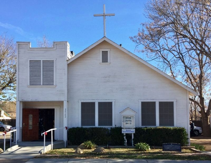
The Acton Community Presbyterian Church began as the Union Moral and Religious Association of Acton. The association's first meeting was held on April 28, 1888. The first formal service took place on June 17, 1888 at the Little White School . . . — — Map (db m127488) HM
The first adobe schoolhouse in 1869 was located near Ravenna, and served the children of miners and ranchers covering a 2,500 square mile area. A subsequent structure, built in 1870, was destroyed by flood in 1880. The present brick schoolhouse, . . . — — Map (db m145704) HM
We welcome visitors to the Historic Acton Cemetery. Out of respect for church members, relatives, and descendants of those buried here, we ask that you treat this sacred site with care and reverence.
John and Wilhemina Duehren arrived in . . . — — Map (db m145703) HM
Welcome to the site of Ballard Mountain, so named in honor of a courageous African-American community leader and pioneering homesteader in Seminole Springs, John Ballard (c. 1830-1905), in fitting recognition of his contributions to the civic . . . — — Map (db m226225) HM
Ladyface Mountain climbs to 2,031 feet above sea level and is visible for many miles.
Legend has it that the Chumash Indians, who used the mountain as a perch to view the
entire Conejo Valley, gave the mountain the name "Ladyface."
The . . . — — Map (db m200712) HM
Destination for a Sunday Drive
During the Great Depression, two Hollywood visionaries
bought this land, right down the road from the exclusive
Malibou Lake Mountain Club.
Called Lake Enchanto, it was created as a . . . — — Map (db m228725) HM
Rancher John Morrison and his family occupied this historic house in 1904. They lived and worked here for almost 60 years. Morrison‘s family cleared land to grow hay and raised horses and cattle to sell at nearby markets. They also built barns, . . . — — Map (db m167302) HM
You've seen Western Town in hundreds of movies, TV shows and commercials. It all started back in 1927 when Paramount Pictures purchased 2,700 acres of the old Rancho Las Virgenes for use as a "movie ranch."
"Cisco Kid," "Dr. Quinn, Medicine . . . — — Map (db m150029) HM
Memorial Ceremony honoring Horace Marden Albright (January 6, 1890 - March 28, 1987)
His footprints are on the United States and
the world because all other national park systems
are modeled on the one he built.
April 4, 1987, . . . — — Map (db m236742) HM
A Future President’s Ranch
By 1951, then actor Ronald Reagan purchased several parcels creating the approximately 357-acre ranch that spreads out before you and runs for 1.5 miles along Mulholland Highway. For the next ten
years, . . . — — Map (db m236739) HM
Daughters of the American Revolution commemorate the significant role the
Reyes Adobe historical site played in the development of California and its
history. The property was a stop along the state's famous El Camino Real. — — Map (db m154344) HM
Before you stands the beautiful "Devil's Punchbowl Wildlife" Civic Art mural, painted
by artist Aaron Morse in 2020 in collaboration with the L.A. County Arts Commission.
Originally created for Devil's Punchbowl Natural Area, a sister facility . . . — — Map (db m274903) HM
While archaeological evidence puts human inhabitance here
back at least 4,500 years, it is believed that the first European
contact in this area may have only occurred in 1772. In less
than three centuries, drastic changes to the land and . . . — — Map (db m262556) HM
Prior to European contact in the early 1700s, Tataviam ancestors lived here for over 1,300 years, with
archaeological evidence indicating human life here at least 4,500 years ago. We have knowledge of many
parts of their lives here, even . . . — — Map (db m263070) HM
While the Vasquez Rocks area had not seen long term settlement since the decimation
of the Tataviam village in the early 1800s, changes in transportation and industry painted a
different picture by the century's end. While Agua Dulce was . . . — — Map (db m262566) HM
You may not have realized it, but the ground you are standing on is part of one of the longest and most scenic continuous
trails in the world. To your left, this trail meanders 2,397 miles to the Canadian border; to your right, it continues for . . . — — Map (db m263075) HM
While the 1930s were difficult for most families living in this area, the Asher family experienced
life here in a different way. Coming from a place of wealth and financial stability, they found
enjoyment and peace at their "Triple-A" Ranch, . . . — — Map (db m262575) HM
If you were to spend any amount of time in our Interpretive Center, you may hear
a patron ask us a question that makes us smile - "I'm not sure if I imagined this,
but when I was a kid, I remember a huge castle that was here. Was that . . . — — Map (db m263066) HM
Occurring in phases from the mid-1800s through the 1960s, private land ownership
here was short on the extensive timeline of human inhabitance. It's hard to imagine
the land before you as private property, but where you stand was the front . . . — — Map (db m262644) HM
The mid-1800s saw Vasquez Rocks quiet, emptied of its Tataviam inhabitants. California underwent
drastic changes under Spanish, Mexican, and American rule. The Gold Rush brought an influx of
settlers, increasing racial hostility and . . . — — Map (db m262562) HM
While life in the Vasquez Rocks neighborhood during the 1920s-60s was challenging, it was also
unique and entertaining. Among the quiet junipers, you might see a wagon train, dinosaurs, aliens,
or astronauts. While you may not have running . . . — — Map (db m262585) HM
From where you stand to as far as your eyes can see is the cherished homeland of the Fernandeño
Tataviam Band of Mission Indians. While the influence of their ancestors may not seem immediately
visible, the landscape that you see before you . . . — — Map (db m262659) HM
Ray A. Toney and his son Edward A. Toney built this ranch-style residence on property homesteaded by William H. Krieg, Ray's uncle. The Toneys, a pioneering Agua Dulce family, built the residence during the Great Depression using wood salvaged . . . — — Map (db m133731) HM
After a century as privately-held land, Vasquez Rocks entered the mid-1960s as a public park for the first time. While many
years of interest were delayed with budget shortfalls, support from the local, state, and federal levels finally led to . . . — — Map (db m262617) HM
Dedicated December 18, 1982
by the Alhambra City Council
and the
Alhambra Redevelopment Agency Board.
This Brown Street Clock
marked the time and location
of Henry E. Wellman Jewelers
since 1913.
The clock has been restored
to its . . . — — Map (db m190603) HM
Built for
U.S. Maritime Commission,
Hull No. V-81,
by
California Shipbuilding Corporation,
Los Angeles, California,
February 1945.
America's S.S. Victory Ships
"Ships for Victory"
S.S. Victory ships . . . — — Map (db m276390) HM
Erected in commemoration of Alhambra’s First Centennial (1903 - 2003).
Dedicated to the memory of
Alhambra's Founding Father
Benjamin Davis Wilson
(affectionately known as Don Benito)
1811 - 1878.
With multiple blueprints . . . — — Map (db m266226) HM
Founder - Benjamin D. "Don Benito" Wilson.
First house erected - 1873.
Incorporated - July 11, 1903, population 600.
Charter City - January 30, 1915. — — Map (db m276391) HM
In celebration of the City of Alhambra’s Centennial in 2003 a time capsule was placed within this foundation on November 12, 2004.
During our centennial year we were proud to honor our past, celebrate our present and imagine our future.
. . . — — Map (db m266227) HM
John Woodbury, founder of Altadena with his brother
Fred, first saw our town's iconic conifer, Cedrus
deodara, touring Italy in the 1870s. After the United
States Department of Agriculture assured him
the Himalayan native would grow here, he . . . — — Map (db m251768) HM
Altadena, an unincorporated area within Los Angeles
County, is a town pressed up against the rugged San
Gabriel Mountains. It gained its separate and distinct
identity over time, often in resistance to its southern,
western, and eastern . . . — — Map (db m251773) HM
In the late 19th and early 20th centuries, African American soldiers
played a major role in the United States military. These men were known as
the Buffalo Soldiers.
Buffalo Soldiers was a nickname given by Native Americans to . . . — — Map (db m251709) HM
The 135 Deodar Cedar trees were planted in 1885 by the Woodbury Family, the founders of Altadena. First organized by F.C. Nash in 1920, the "Mile of Christmas Trees" has been strung with 10,000 lights each holiday season through the efforts of . . . — — Map (db m143798) HM
Cobb Estate sits at the mouth of the Las Flores Canyon
and across from Echo Mountain, the historic site of the
Incline Railway which traveled to the "White City" at the
summit - first stop along the Mt. Lowe Scenic Railway.
Charles and . . . — — Map (db m243445) HM
marker at amphitheater:
Built by
United States
Works Progress
Administration -
1938.
marker at basketball courts:
Improved by
Works Progress
Administration -
1937. — — Map (db m243384) HM
Victor Ving @greetingstour
Spray paint & enamel
Production Team: Lisa Beggs, René Amy, Alec Pelsone, Leanna Viers, Ray Abary & Swank SH
The Greetings Tour is a nationwide mural project by muralist Victor Ving & photographer
Lisa . . . — — Map (db m265769) HM
Designed by Whitney R. Smith in
the Early Modern architectural
style and built in 1941 for Evelyn
and Jackson Holmes.
Designated
on February 9, 2021 by the Board
of Supervisors.
Historical Landmarks
and Records Commission. — — Map (db m192512) HM
You're looking out at El Prieto Canyon. In Spanish
"El Prieto" refers to the dark one - and this scenic
place was named for Robert Owens. He settled here
in the early 1850s, after being born into slavery and through
years of hard labor . . . — — Map (db m251867) HM
Named in honor of David J. MacPherson who planned and engineered Mt. Lowe Railway and Echo Mountain Incline, in use 1893 to 1938. — — Map (db m153312) HM
Mt. Lowe Scenic Railway was considered an engineering wonder
and southern California's most popular tourist attraction
during its heyday, carrying a total of 3.1 million visitors.
8th Wonder of the World
The brainchild of . . . — — Map (db m243446) HM
Lt. O. Oliver Goodall lived at 679 W Harriet Street from 1961 until his death in
2010 and made a powerful impact on his adopted communities of Altadena and Pasadena, in addition to contributing to elevating the dignity and civil rights of . . . — — Map (db m145504) HM WM
Owen Brown is buried at the top of
this hill, "Little Round Top," named for
the heroic stand by Union troops
at the Battle of Gettysburg. He and his
brother Jason lived nearby on land
they homesteaded in the 1880s. He
was the last survivor . . . — — Map (db m251866) HM
Here is a replica of the grave of Owen
Brown, son of John Brown. The elder Brown
violently opposed slavery and led a raid of
the U.S. armory at Harper's Ferry, Virginia
in 1859 hoping to arm slaves and start
an insurrection. His son, Owen, . . . — — Map (db m251760) HM
Look down El Molino ('the mill') Avenue in front of you. Five miles south is the first mill built for the San Gabriel Mission. The "Old Mill" (circa 1810) is among the San Gabriel Valley's earliest infrastructure — and now houses an art gallery. . . . — — Map (db m251763) HM
Getting up into the mountains above Altadena from
downtown Los Angeles used to be as easy as hopping
Lowe Railway, which at the time was the most advanced civil
engineering project in the world. Passengers from Altadena
boarded the railway . . . — — Map (db m251776) HM
In Spanish, "Prieto" means dark. El Prieto Canyon references a person, not the dark shade of its
many mature oak trees. The "El Prieto" of this beautiful canyon was a man named Robert Owens.
Born into slavery in 1806, Robert Owens worked . . . — — Map (db m226463) HM
Woodbury / Story House, built in 1882, has been placed on the National Register of Historic Places by the United States Department of the Interior. — — Map (db m261323) HM
Zane Grey Estate, 396 East Mariposa Street, has been placed on the National Register of Historic Places by the United States Department of the Interior, 2002. — — Map (db m144782) HM
Originally planned as a small clubhouse for friends,
Professor Lowe's Alpine Tavern became the temporary
end of track when funds for construction ran out, then
became the principal tourist attraction, terminus of the
Alpine Division, and . . . — — Map (db m248796) HM
To the memory of Benjamin Davis Wilson, Don Benito, 1811 – 1878, pioneer trapper and settler who came to California in 1841, and in 1864 blazed the trail up this mountain which bears his name. — — Map (db m123037) HM
Cape of Good Hope (top photo)
The Stone Wall that can be seen below you to the right of
the road cut through the ridge is part of a sharp 200 degree curve.
This enabled the railway to cross from Las Flores Canyon (beyond
ridge) to . . . — — Map (db m247616) HM
This 1938 photo shows the cars parked next to the Cable House. The railway ceased operations after the burning of the Alpine Tavern in September of 1936. This left one
person, Guy Fess, to watch over the closed Railway. The 4-passenger cars and . . . — — Map (db m248704) HM
This photograph was taken from the Castle Canyon trail
which is to your left leading into Castle Canyon.
The Casino building was in the area behind this sign
to your right.
The Casino was used for meetings, banquets, and dances. It
was not . . . — — Map (db m248853) HM
You are at the high end of Circular Bridge and looking at
Echo Mountain. At the end of the cleared trail below (old railway
right of way). This famous view was printed on the front cover of
the 'Mt. Lowe Souvenir Photos' for many years. — — Map (db m248705) HM
Guests at the Alpine Tavern could also stay in one of the
20 cottages located along the upper & lower concrete walkways
to the right of this sign. Brackets for the electric lights &
insulators are still in the trees. — — Map (db m249058) HM
In dedication to the Firefighters who heroically defended Wildlife Waystation throughout the entire December 2017 Creek Fire. Our eternal gratitude for their selfless act of bravery - Cal Fire, Contra Costa County Fire, Los Angeles County Fire Dept, . . . — — Map (db m138093) HM
Known to the Mission Padres, Crystal Lake is the only natural lake in the San Gabriel Mountains. R.W. Dawson visited the lake in 1876, and later built a cabin nearby. Pasadena Judge Benjamin Eaton wrote in 1887 that "The water is clear as a . . . — — Map (db m172024) HM
The Dawn Station "Trolley Stop" in this photograph is
located to the left of this sign. A 2.4 mile trail led from Dawn
Station to the mine located down in the canyon. Partially
processed ore from the mine was brought up to this Station . . . — — Map (db m248031) HM
Easter sunrise services were held
here at Easter Rock for many years.
Easter Rock is made up of decomposed
rock and has weathered over the years.
The plaque disappeared long ago. It
read as follows:
Easter Rock
First . . . — — Map (db m247507) HM
Eaton Canyon Saddle
Eaton Saddle is located between San Gabriel
Peak (6,161') and Occidental Peak (5,732') and
on the ridge leading from Red Box to Mt. Wilson.
It separates Eaton Canyon to the south from
Falls Canyon to the . . . — — Map (db m247457) HM
The world famous Echo Mountain
House was completed in November 1894. It was a
beautiful L-shaped building, four stories high with a
400-foot wing offering a southern exposure. A massive
metal dome crowned the structure. The entire . . . — — Map (db m248028) HM
From his Civil War days on, Professor Lowe loved pomp and
ceremony. Completion of each new installation and hotel
provided an excuse for a celebration.
Echo Mountain House was finished on November 24, 1894.
In this view, Professor . . . — — Map (db m248591) HM
This service pit was built in
1914 to maintain the cars that ran between Echo Mtn and Alpine Tavern. The 127
curves of the route to the Tavern wore heavily on the wheel flanges. This required
regular wheel replacement. Because of the . . . — — Map (db m248594) HM
Echo Mountain is so named because of the many
echoes that can be heard across Rubio Canyon. The
Mt. Lowe Railway installed an Echo Phone similar
to this one in the early 1900's. The base of the
original Echo Phone can be seen behind this . . . — — Map (db m248029) HM
This is the view you would have as you approach the White City from the
Alpine Tavern in 1899. The tank-like structure located to the lower far
right was used for storage of lighting and heating gas piped up from
Pasadena, eight miles away. . . . — — Map (db m248703) HM
The last of the 18 bridges between Echo Mtn. & Alpine
Tavern was this large "S" shaped bridge which the trolleys
crossed to reach the Alpine Tavern. Both end foundations of the
bridge are still visible. If you look across the canyon to the . . . — — Map (db m248030) HM
The construction of the White City and rail system was
quite a feat of engineering for the time. However, even
the technology of the day could not protect the White
City from the forces of nature. Fierce winds started a
fire that destroyed . . . — — Map (db m248596) HM
In this area it was necessary to blast a path for the railway
out of the hard granite. The cutting of the Granite Gate itself took
8 months with the walls being left intact on Professor Lowes'
orders. This "Gate" provided a picturesque frame . . . — — Map (db m247573) HM
This area was originally homesteaded by John Henninger
in 1886. From 1902-1907 the United States Forest Service
maintained on the flats an experimental nursery, in charge
of Arthur Lukins. The results of these experiments, as
shown by the . . . — — Map (db m272909) HM
High Bridge was a trestle which allowed the railway to
maintain a straight right-of-way while crossing a steep
rock face. The bridge itself was 113 feet long and 35
feet high. It is probable that most passengers preferred
the safety of . . . — — Map (db m248544) HM
Inspiration Point is about a ten minute walk
from the Alpine Tavern over part of the never
completed railway grade to the summit of Mt.
Lowe. From this shelter, sighting tubes helped
visitors locate places of interest, including
Catalina . . . — — Map (db m247503) HM
Congratulations!!! At this stop you were halfway to wherever you were going. Bakersfield is 64 miles to the north and Los Angeles is 62 miles to the south. Weary travelers and truckers took advantage of the garage service and restaurant . . . — — Map (db m152072) HM
Primary surveying for the Ridge Route began in 1912, and grading by hand crews and mule-drawn scrapers was completed in 1915. A total of one million cubic yards of earth was removed to complete the Route.
This camp was one of the . . . — — Map (db m152076) HM
This point is the highest point (4,213 feet) on the Old Ridge Route. From the origin of the Route in Castaic to the south, travelers climb 3,100 feet in 26 miles to reach this point, many times wearing out their tires or overheating their . . . — — Map (db m152073) HM
The railway from Echo Mountain to the Alpine Tavern
covered 3½ miles with 127 curves and 114 straight segments.
You are looking at the longest straight segment on that route -- a
mere 225 feet long (less than 1/20 of a mile). — — Map (db m248748) HM
On this pier in 1926
Albert Abraham Michelson
measured the velocity of light by means of a
beam of light transmitted to
Mount San Antonio
and reflected back to this station. — — Map (db m57274) HM
This monument is dedicated to the memory of Lord Baden-Powell of Gilwell, O.M. Founder of Boy Scouting In the year of his 100th anniversary 50th anniversary of world Scouting 47th anniversary of Scouting in America September 1957
Erected . . . — — Map (db m189748) HM
The foundations for the 1895 Power
Plant are in the area right of this sign.
The foundations of the 1899 Power
Plant are to the left.
All of the foundations for the Motors
and Generators shown in the drawings
are visible along with the . . . — — Map (db m248808) HM
Cable wheel, last remnant of Incline section, Mt Lowe Railway, Rubio Canyon to Echo Mt, 1893-1938, built by Prof. T.S.C. Lowe, D.J. Macpherson, engineer. — — Map (db m122608) HM
Mt. Lowe Scenic Railway was considered an engineering wonder
and southern California's most popular tourist attraction
during its heyday, carrying a total of 3.1 million visitors.
8th Wonder of the World
The brainchild of . . . — — Map (db m247456) HM
This summit, previously known as Oak Mountain, was named Mt. Lowe
in the fall of 1892. At the time railway construction was going
on in Rubio Canyon and Echo Mtn. Professor Lowe had planned to
run the railway to this summit and build a large . . . — — Map (db m247464) HM
The National Forest Inn consisted of neat, white clapboard buildings, one of which was built on stilts to compensate for the steepness of the landscape (note building on left).
The U.S. Forest Service also had a Station here for the . . . — — Map (db m151496) HM
The first .9 miles of the Alpine Division required 9 bridges to
reach the present day Fire Road. It took about 20 minutes
to travel to the Alpine Tavern by Trolley (3.5 Miles).
-The small arrow locates present trail / road junction. . . . — — Map (db m248578) HM
An early 1900 photograph showing car #123 crossing High
Bridge on its way to the Alpine Tavern. Car #123 started
the 3½ mile journey from Echo Mountain, which is
located just out of this view to the right, approximately
2/3 of a mile away. — — Map (db m248792) HM
Inspiration Point is about a ten-minute walk along part
of the never-completed railway grade to the summit of
Mount Lowe. From a rustic shelter there, sighting tubes
helped visitors locate places of interest, including Catalina Island, 60 . . . — — Map (db m272910) HM
Visitors to Inspiration Point remember the tiny "One
Man and Mule Railway," a little tourist tramway that
connected Inspiration Point to Panorama Point overlooking Eaton Canyon. Operated by one man and his
cantankerous mule, Herbert, the . . . — — Map (db m247505) HM
In memory of
Cecil B. DeMille,
his Paradise Ranch
was given by
the Cecil B. DeMille Trust
with the hope that it would be a
Paradise for children. — — Map (db m218483) HM
The first hydro-electric installation in California for long-distance transmission of alternating current at high voltage was built in 1892 on San Antonio Creek below this spot by the San Antonio Light and Power Company organized by Dr. Cyrus . . . — — Map (db m149504) HM
As a road-weary traveler, you could find whatever you needed during your passage over these steep mountains. Not only was this the location of a restaurant, gas station, garage, store, and water trough for overheated cars, but above the . . . — — Map (db m152074) HM
Traveling north for the next 17.6 miles, you will see rock and concrete monuments on the roadside. These monuments tell a story of a bygone era. Each one represents a place or business establishment that was on the site. When this twenty foot . . . — — Map (db m151528) HM
This resort was established around 1915 and was constructed with rough-hewn logs and rugged stone, reflective of the “Western Alpine” style popularized by the National Parks in the early 1900s. It differed from the other stops along the . . . — — Map (db m152075) HM
Sentinel Rock was a well-known feature along the route to Alpine Tavern. In this photograph, the trolley has just passed over the ninth bridge on its way to Cape of Good Hope. The Cape of Good Hope marks the point where the tracks cross from Las . . . — — Map (db m248626) HM
National Historic Lookout Register
This certificate officially recognizes
Slide Mountain Lookout,
Los Angeles County, California,
as meeting those standards of historic and cultural significance
established by the American . . . — — Map (db m272373) HM
This stairway, which can be seen today, was actually the loading
platform for the Incline cars.
The Incline cars were designed with level floors and seats as
they traveled the steep 3,000 foot long incline carrying guests
between Rubio . . . — — Map (db m248735) HM
This remarkable 110-foot deep cut was excavated by large steam-powered shovels, which were hauled up the ridge by teams of mules. Though not maintained for over 60 years, these cut slopes remain secure today, a testimony to the engineering . . . — — Map (db m151495) HM
3212 entries matched your criteria. The first 100 are listed above. Next 100 ⊳