116 entries match your criteria. The first 100 are listed. The final 16 ⊳
Acadian History Historical Markers
Markers, regardless of organization, commemorating Acadian culture and history as found in France, New France, the Canadian Maritimes, Maine, Louisiana and elsewhere.
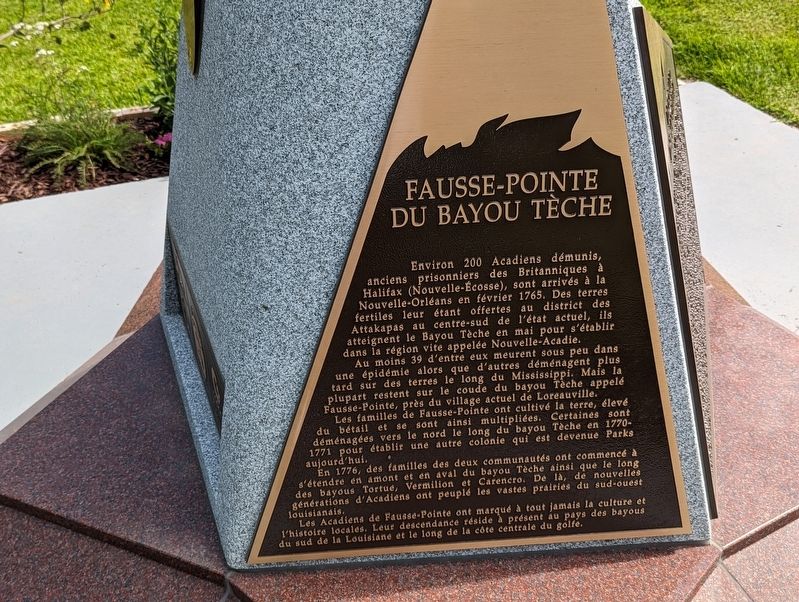
About 200 destitute Acadians, former
prisoners of the British in Halifax, Nova
Scotia, arrived in New Orleans in February
1765. Offered fertile land in the Attakapas
District of what is now south-central Louisiana,
these exiles reached Bayou . . . — — Map (db m228254) HM
English Side In Spring 1765, during the Spanish Rule of
Louisiana, approximately 200 Acadian refugees
representing 60 families were settled here on
the Teche Ridge in three encampments along
the "Fausse Pointe" that includes . . . — — Map (db m228283) HM
Panel 1 English L'Acadie, established by France in 1604, was a
strategically located and highly coveted colony. In 1713, it
was handed over to England and renamed Nova Scotia. The
foundation of Halifax, in 1749, led part of the. . . . — — Map (db m228406) HM
pre-1699 pre-1699: Ancestors of the Ishak (Atakapa) and Chitimacha people hunt bison, deer, bear and small game; harvest fish and shellfish. The Chitimacha's territory encompasses the entire Atchafalaya Basin, lands west . . . — — Map (db m136633) HM
1775-1783 1775-1783: United States War of Independence. In support of the U.S., in 1779 the Spanish military captures British-held Baton Rouge, with the use of Native American, French, Spanish, and free persons of color . . . — — Map (db m136634) HM
Refugees came overland 1756-57. In vicinity was 1762 grant to Jacques Cantrelle, Sr. of France after whom Church and Parish were named. Section once included in Les Oumas, Eveche of Quebec. — — Map (db m86620) HM
The original Deportation Cross, near Grand-Pré National Historic Site in Nova Scotia is located in the vicinity of the embarkation of the victims of the Acadian Diaspora of 1755. Dedicated on July 24, 1924.
La Croix originelle de la . . . — — Map (db m85293) HM
Over 2,500 Acadians settled in the
Spanish colony of Louisiana between 1764
and 1788, Although victims of the
Deportation, none were deported directly to
Louisiana.
Acadians made their way to Louisiana from
various locations. The first group, . . . — — Map (db m123326) HM
L'Acadie, established by France in 1604, was a
strategically located and highly coveted colony. In 1713, it
was handed over to England and renamed Nova Scotia. The
foundation of Halifax, in 1749, led part of the Acadian
population to move to . . . — — Map (db m123267) HM
The monument in front of you commemorates the "Great Upheaval" of the Acadian people from their homeland in what is now Nova Scotia, Canada. Beginning in 1755, Acadian villagers, caught in a power struggle between France and England were uprooted - . . . — — Map (db m174334) HM
Frenchman Bay, in front of you, and other prominent names commemorate the region’s rich French heritage, “Acadia” stems from “Arcadia,” a term used by Giovanni Verrazano’s expedition to describe the Atlantic coast in 1524. . . . — — Map (db m105626) HM
Near this town on 3rd September 1755, a detachment of Major Frye's troops, sent from Fort Cumberland to destroy Acadian settlements on the river and compel the people to surrender for deportation, was defeated by a French force under Charles . . . — — Map (db m106630) HM
Named on June 24, 1604 – the feast day of St. John the Baptist – during the expedition of Sieur de Monts and Samuel de Champlain the river originates in northern Maine and flows 673 kilometers emptying into the Bay of Fundy at Saint . . . — — Map (db m138997) HM
English:”Having found no place more suitable than this island... Sieur de Monts… allowed me to draw up the plan of our settlement."
Seventy-nine men, including noblemen, artisans, labourers, Catholic and . . . — — Map (db m144499) HM
English:
Sieur de Monts named the island Saint Croix Island, and Champlain recorded that: "The island is covered with fir, birch, maple, and oak. It is naturally well located... and is easy to fortify... We considered this the . . . — — Map (db m144498) HM
English:”It was difficult to know the country without having wintered there... Winter came upon us sooner than we had expected..."
Could you survive a winter on Saint Croix Island if...
• dangerous ice cut you . . . — — Map (db m144501) HM
English:
The precise mapping of Acadie in the 17th century was the work of one individual — Samuel de Champlain.
Between May 1604 and August 1605, travelling by barque, pinnace, canoe or on foot, Champlain surveyed and . . . — — Map (db m144500) HM
English:"In order to escape the cold and dreadful winter we experienced on Saint Croix Island, Sieur de Monts decided to move the settlement to another location. Having… found no port that was acceptable to us... we outfitted . . . — — Map (db m144502) HM
English:
Welcome On Saint Croix Island in 1604, French nobleman-courtier Pierre Dugua Sieur de Monts established a settlement. This outpost was the first attempt by the French at year-round colonization in the territory they . . . — — Map (db m144495) HM
English: Samuel de Champlain, explorer and geographer on Sieur de Monts' expedition, recorded in late June 1604 that:
”...we entered a river... wherein...we found two islands — one very small and near the western . . . — — Map (db m144496) HM
English:
The Micmac, Maliseet, and Passamaquoddy hunters and traders provided a commercial lifeline for Sieur de Monts' colony. Their first-hand knowledge of the territory allowed these entrepreneurs to control the supply of furs. . . . — — Map (db m144497) HM
English
From the Chiputneticook Lakes, the waters of the St. Croix River tumble through rolling Appalachian scenery to one of the most historic estuaries in Canada, at Passamaquoddy Bay. Here, French colonization in North America began . . . — — Map (db m77395) HM
English:
The Grand Dérangement
L’Acadie, established by France in 1604, was a strategically located and highly coveted colony. In 1713, it was handed over to England and renamed Nova Scotia. The foundation of Halifax, in 1749, . . . — — Map (db m80580) HM
English:
Because of the vicissitudes of war, the Acadians, pioneers of this country, were dispersed in 1755. The arrival of Alexis Landry at Ste. Anne de Bocage, soon after 1755, symbolizes the return of the Acadians to their beloved . . . — — Map (db m80579) HM
Français:
À l'automne 1767, les familles Gueguen, Arseneau, Hébert et Bourg reçoivent les premières concessions de terres accordées à des Acadiens après le Grand Dérangement.
En novembre, Cocagne devient la première communauté . . . — — Map (db m139701) HM
Français: « Chances égales pour tous ». Avec cette phrase tout simple, Louis J. Robichaud a changé le cours de l’histoire de l’Acadie et du Nouveau-Brunswick. Il inscrit, pour tout citoyen, de quelque classe qu’il soit, la dignité . . . — — Map (db m151247) HM
Français:
Né à Saint-Louis-de-Kent et ordonné prêtre en 1870, Mgr Richard fut l'une des figures de proue de la renaissance acadienne. Il stimula la colonisation afin de centrer l'exode yeti les États-Unis, fonda des écoles, des . . . — — Map (db m139702) HM
This sculpture was erected
in memory of our ancestors
who were the founders of
Acadia of the Lands and Forests.
Commemorating the
2014 Congrès mondial acadien
which was held in our region. . . . — — Map (db m125346) HM
Français: Les Acadiens sont les premiers colons européens à s'établir à la baie de Fundy, au début du 17e siècle. Ils transforment le paysage en asséchant des marais salés et en construisant des levées et des aboiteaux pour créer . . . — — Map (db m150975) HM
English: The Grand Dérangement L’Acadie, established by France in 1604, was a strategically located and highly coveted colony. In 1713, it was handed over to England and renamed Nova Scotia. The foundation of Halifax, in 1749, . . . — — Map (db m150940) HM
English:400th anniversary celebration of the 1st Acadian settlement. Dedicated to those Acadians who were part of the history of the Village of Dorchester and area. Français:Fêtes du 400e anniversaire de . . . — — Map (db m193196) HM
This part of "Le Coude" (The Bend) was in earlier times called Terre-Rouge. Three families from the Grand-Prée region first settled here:
Jean Babineau & Isabelle Breau, circa 1733,
followed by Joseph Breau & Isabelle Thibodeau
and Charles . . . — — Map (db m106603) HM
English
When the French settled at Port-Royal in the early 1600s, the shores of the Annapolis River were bordered with tidal salt marsh. In the 1630s, the French at Port-Royal started reclaiming this fertile land by building dykes.
The . . . — — Map (db m78488) HM
English
From its strategic setting, Annapolis Royal has witnessed pivotal events in the history of European settlement in Canada. Located on a former Mi’kmaq meeting place, the townsite and its environs were known as Port-Royal by the . . . — — Map (db m78670) HM
English
Two cemeteries are located in this burial ground: the earlier Acadian parish cemetery and the later Church of England cemetery. The wooden markers once placed on most of the graves have long since decayed. The gravestones that . . . — — Map (db m78605) HM
Two markers are located on these monument. Charles Fort / Le fort Charles English
A group of about 70 Scottish settlers began a colony here in 1629, eight years after King James I granted ‘Nova Scotia’ to Sir William . . . — — Map (db m78486) HM
In memory of
Daniel Auger de Subercase
1663-1732
Chevalier of the Military Order of St. Louis, last French commander of this fort and defender of Acadie.
Honour to unsuccessful valour — — Map (db m78442) HM
English
In September 1744, French soldiers and Aboriginal warriors attacked this fort. The took advantage of the overcast and rainy weather to attack at night under cover of darkness, sometimes managing to slip onto the outer works of the . . . — — Map (db m78606) HM
English
A French Huguenot in the British army, Mascarene served here from 1710 to 1750. He was a member of the Council of Nova Scotia (1720-50), lieutenant-colonel of Philipps’ Regiment (1742-50), and administrator and commander in chief . . . — — Map (db m78491) HM
English
When the French first came to the Annapolis Basin, Samuel de Champlain called it “Port-Royal” in recognition of its great size.
Eventually, the area surrounding the basin and along the Annapolis River became known as . . . — — Map (db m78449) HM
To the illustrious memory of Lieut. Gen’l Timothé Pierre du Guast,
Sieur de Monts,
the pioneer of civilization in North America, who discovered and explored the adjacent river, A.D. 1604, and founded on its banks the first settlement of . . . — — Map (db m78443) HM
The Black Hole
The French built this powder magazine into the earthworks of their new fort in 1702. Both the French and the British used it to store gunpowder. In the early 1800s, it was used briefly as a prison or “Black Hole.” . . . — — Map (db m78601) HM
English
You are standing on the west bastion which, in the 1700s, was the principal bastion. This being the closest bastion to the river, a flag was flown here to show approaching vessels who controlled the stronghold.
Important . . . — — Map (db m78603) HM
In the early hours of July 4, 1724, a combined force of Mi’kimaq and Maliseet warriors attacked Annapolis Royal, slipping into the town as its residents slept. They attacked the fort from the cover of the hollow near the east bastion. Although the . . . — — Map (db m78702) HM
English:
In 1713, France decided to found Louisbourg to defend her colonial and maritime interests in North America. As capital of the colony of Isle Royale and guardian the Gulf of Saint. Lawrence, it became the most important French . . . — — Map (db m79915) HM
English:
This tablet commemorated the valour and endurance displayed against overwhelming odds, by the French forces, who, in 1745 and again in 1758, garrisoned the defensive batteries on the Island opposite the entrance to the harbour of . . . — — Map (db m79968) HM
French Naval Guns raised
by the Dominion Coal Company in 1895
from the bottom of Louisburg Harbour
and mounted at the Louisburg Railroad Station
presented to the Fortress of Louisburg
National Historic Site
by the
Dominion Steel . . . — — Map (db m142962) HM
English:
During the 1745 and 1758 sieges the attackers built artillery batteries on Lighthouse Point to silence the Island Battery. This would have allowed warships to enter the harbour for a combined land and sea assault on the town. The . . . — — Map (db m142964) HM
English:
Louisbourg’s destiny has been largely shaped by its harbour. Well-protected, relatively deep and close to the fishing banks, it was the harbour that attracted the French to settle here in the 1700s. In the 19th century ice-free . . . — — Map (db m79963) HM
English:
Captured in Africa at the age of 19 and transported to Ile Royale, where she was sold to a member of the colonial elite, Marie Marguerite Rose is seen to be a key figure of the initial phase of Black slavery in Canada. Gaining her . . . — — Map (db m79917) HM
Two panels make up this marker
Slavery / Esclavage
English:
Marie Marguerite Rose was the name given to a young woman captured in Guinea, Africa, sold to French traders and brought to Louisbourg in 1736 as a slave for . . . — — Map (db m79918) HM
English: Between 15 May and 15 July the ocean in front of you is dotted with the buoys of the lobster fishery. The Mi’kmaq as well as the French and the English ate lobster and other shellfish during the 18th Century. During the 1754 siege . . . — — Map (db m79941) HM
English: In both sieges the attackers made their initial landings in this cove. In 1745 the French defended the cove with only a small detachment but in 1757 they built and garrisoned extensive fieldworks here. The following year . . . — — Map (db m142966) HM
English: Here, 8th June, 1758, the men of Brigadier General James Wolfe’s brigade, after having been repulsed with heavy loss by the French troops entrenched westward made their gallant and successful landing.
Thus began the operation . . . — — Map (db m79938) HM
Français:
Deux mille pieds au sud-est de cet endroit se trouvent les vestiges de la première exploitation régulière d’une mine de charbon en Amérique, commencée par le Français en 1720. Cette industrie, modeste à son origine, est . . . — — Map (db m139292) HM
Commercial coal mining began in Port Morien in 1720 after a mine had been opened to supply The Fortress at Louisbourg. This was the first commercial coal mine in North America. After the English victory at Louisbourg in 1758, the mine remained in . . . — — Map (db m139293) HM
English: This was the chief route of the French and Indians from Cobequid to Isle St. Jean and Louisbourg and later of the British from Halifax to Charlottetown.
Français: C’était la route principale des Français . . . — — Map (db m139192) HM
In 1760-62 near this Head of Cobequid Bay the first English speaking settlers of the Townships of Onslow and Truro landed. Of Ulster Irish, Scottish and English stock, these pioneers were among those brought to Nova Scotia from New England by the . . . — — Map (db m108717) HM
In this harbour Capt. David Donahew of New England with three armed vessels surprised Lieut. Paul Marin's allied force en route from Annapolis Royal to Louisbourg. He drove them ashore, disheartened the Canadian Indians and prevented the French . . . — — Map (db m108133) HM
[Face]
The Acadian village of Beaubassin on this site was founded by settlers from Port Royal around 1672. Upon the arrival of Major Charles Lawrence with British troops in April 1750, the French authorities had the village destroyed in . . . — — Map (db m106953) HM
This area was the site of the Acadian village of Beaubassin, first known Bourgeois settlement. Raided in 1696 and again in 1703 by a force from Boston under Captain Ben Church. Occupied by French troops in 1746 who travelled on snowshoes in . . . — — Map (db m106951) HM
The First Nations
Native peoples have lived around the Chignecto Isthmus for thousands of years. Travelling in family groups and small nomadic bands, they moved from area to area harvesting seasonal food sources.
Early French explorers were . . . — — Map (db m112112) HM
Fort Lawrence
In the 18th century, the Chignecto Isthmus played an important role in the struggle between France and Britain for North American supremacy. In 1713 the Treaty of Utrecht had failed to clearly establish the border of Nova . . . — — Map (db m112110) HM
Fondateur, vers 1672, de Beaubassin premier établissement dans la région de la rivière Missagouèche et initiateur de l'agriculture maraîchère en Acadie
Jacob Bourgeois arriva à Port-Royal en 1641 à titre de chirurgien pour la colonie . . . — — Map (db m107012) HM
Important as a centre for the North Atlantic fisheries from
the 16th century, the islands in Canso Harbour offered a
safe haven for fishermen. First frequented by the French
and Basques, the area became the site of an extensive . . . — — Map (db m138598) HM
During the seventeenth century French fishermen came from Cape Breton, across Chedabucto Bay, to fish for cod in thirty foot shallops. Later, the New England colonists came in their schooners. They fished the Banks and dried their fish . . . — — Map (db m140536) HM
Fishermen sailed to this coast before the earliest explorers. In the early 1600s French and Basque fishermen dropped handlines in the waters.
By 1725 New Englanders were pulling in cod worth 150,000 pounds (New England currency) . . . — — Map (db m140554) HM
The first settlers of Port Royal must have been aware of the extraordinary fertility of the immense salt marshes that surrounded them The height of the wild grasses alone would have been a clear sign of very productive soil. Until the . . . — — Map (db m141244) HM
Many of the Acadians who escaped, or survived the Great Upheaval of 1755 to 1763, either died of exposure, or were captured and imprisoned as "Prisoners of War". Makeshift detention centers were often old trading posts such as Fort Edward . . . — — Map (db m141399) HM
This monument is the creation of Raymond Delorey of Larrys River and the idea was conceived by members of "la Société des Acadiens de la Région de Tor Baie” under the direction of its Executive, President, Jude Avery, Vice President, . . . — — Map (db m141175) HM
In 1603, Henry IV, King of France, granted Pierre Dugas, Sieur de Monts, the right to colonize lands in North America between the 40th and 60th degree north latitude. Along with the right to colonize that extensive region, his company was . . . — — Map (db m141181) HM
Grand Pré (large meadow) settlement began in 1682 when a few families from Port Royal moved there. It is situated near the shores of Minas Basin, an inlet that empties into the Bay of Fundy. By 1707, the population had grown to 580 . . . — — Map (db m141256) HM
Welcome to our Commemorative Park!
This development is a direct result of a cultural awakening following local festivities in 2004, in conjunction with the World Congress of Acadians, which was celebrated throughout Nova Scotia. Our people . . . — — Map (db m141146) HM
French cartographer and geographer, Samuel de Champlain met Basque fisherman and fishery entrepreneur, Captain Savalette, on the north shores of Tor Bay in 1607. According to authenticated records, Champlain and a group of explorers, . . . — — Map (db m141209) HM
Arriving in 1604, the French settlers built a fort on a small island named Ile Ste Croix at the mouth of the Ste. Croix River, which separates present day New Brunswick and Maine. After a disastrous winter, where 35 of the 79 men died of . . . — — Map (db m141190) HM
After many visits to this eastern coastline region of mainland Nova Scotia between the years 1763 and 1797, a determined group of Acadian families from Chezzetcook, who were once again searching for peace and freedom, decided that the . . . — — Map (db m141401) HM
With the founding of Halifax in 1749 as a British naval base, the Acadians became the target of concern and possible displacement. Demands on them to accept and sign an "oath of allegiance” to the British crown were made several . . . — — Map (db m141258) HM
The Deportation began in 1755 and ended with the signing of the Treaty of Paris in 1763. This Treaty not only ended what was perhaps the greatest human atrocity committed in British North America but it also gave Acadians the right to . . . — — Map (db m141389) HM
Over the next eight years, or until the signing of the Treaty of Paris in 1763, the Great Upheaval continued in what has become known as the first act of "ethnic cleansing” in North America. In an ill-conceived and desperate plan . . . — — Map (db m141274) HM
Every summer for more than 40 years,
beginning in 1565, this Basque fisherman
from Saint-Jean-de-Euz sailed to Eskikewa'kik,
a district of Mi’kma’ki within the traditional
territory of the Mi'kmaq. Here, his crew
caught codfish, which . . . — — Map (db m138605) HM
Welcome to Place Savalette This park has been developed to mark and explain the site of the historic 1607 meeting between Basque fisherman/entrepreneur, Captain Savalette and explorer/cartographer Samuel de Champlain
on the shores . . . — — Map (db m139825) HM
Village of Port Felix/Molasses Harbour
Early Acadians called Port Felix Molasses Harbour because of a keg of molasses washing up on shore. Many Acadian settlers arrived about 1797 after
the fall of Louisbourg. Following the American . . . — — Map (db m140390) HM
This plaque is dedicated to the memory of
Pierre Maillard
who served as missionary to the Micmac Indians in this country for over thirty years, who succeeded in reconciling the Micmac to British rule, who celebrated the first mass and opened . . . — — Map (db m77723) HM
This plaque commemorates
the 235th year of
the Grand Pre Marsh Body
1760-1995
in honour of the dykeland farmers,
past and present, for their 235 years
of dedication and sacrifice, and their
continuing struggle to protect and
maintain these . . . — — Map (db m138789) HM
English
The villages of Grand-Pré and Hortonville, and the fertile farmlands which surround them, comprise one of the oldest settlement and land use patterns of European origin in Canada. Acadians began settling near Grand-Pré in the 1680s, . . . — — Map (db m78721) HM
English
This statue of Evangeline, heroine of Longfellow’s epic poem, Evangeline: A Tale of Acadie, is a powerful emotive symbol of the Deportation. It connects the story of Evangeline to the history of Grand Prê.
Two famous . . . — — Map (db m78723) HM
On February 11, 1747 Grand
Pré was the scene of a surprise
attack on Col. Arthur Noble's
detachment of British troops from
Massachusetts who were billeted
in the houses of the inhabitants.
A French and Indian force under
Coulon de . . . — — Map (db m140191) HM
English
The expulsion of the Acadians began in 1755, on the eve of the Seven Years’ War. Frustrated with the neutrality of the Acadians who refused to swear an unconditional oath of allegiance to the Crown, British forces began the . . . — — Map (db m78722) HM
How the Battle Unfolded
During the first half of the 18th century, France and Great Britain were at war for imperial domination of North America. Most Acadians, including those at Grand Pré, wanted to stay out of the conflict and be . . . — — Map (db m140430) HM
In 1755, the worldwide struggle for empire between Great Britain and France had tragic consequences for the Acadians of Les Mines and elsewhere in Nova Scotia/Acadie
Lt-Col. John Winslow was the Massachusetts officer in charge of the . . . — — Map (db m140393) HM
Le lit desséché du crique que l’on aperçoit dans le pré à quelques pas d’ici est l’endroit ou furent embarques sur les chaloupes les victimes du Grand Dérangement de 1755 pour être transbordes sur les transports ancres dans le Bassin des Mines. . . . — — Map (db m138777) HM
English
This site known as the Old French Cemetery, is one of the few links to the Town’s Mi’kmaq and Acadian past. Known by the Mi’kmaq as Merligueche meaning whitecaps which topped the waves in the harbour, the name continued to be used . . . — — Map (db m78260) HM
English
More than a century before the founding of Lunenburg, these lands were inhabited by French-speaking settlers, known as Acadians. Their settlements, including one at Lunenburg, then known by its Mi’kimaq name, Merligueche, began in . . . — — Map (db m78294) HM
English
Nicolas Denys, a merchant from Tours, France, arrived here in 1650 to restore an abandoned Portuguese fort called San Pedro. He renamed it Saint-Pierre, and set out to pursue fishing and trading - primarily in furs. Fort . . . — — Map (db m78727) HM
English:
Settled, 1629, by Captain Charles Daniel, and site of an early Jesuit Mission. Selected, 1713, as a naval base and one of the principal places in Isle Royale, named Port Dauphin and strongly fortified. Its importance declined with . . . — — Map (db m80005) HM
English:
With its close proximity to abundant fishing grounds, sheltered cove and excellent fish-drying conditions, Neil's Harbour was a popular fishing base for both French and Scottish settlers in the 1700's.
Neil MacLennan, . . . — — Map (db m139870) HM
Cheboque
The name "Cheboque" comes from the Mi'kmaw word for "big marshes", a very accurate name for this area. Beginning at Arcadia, the Cheboque salt marsh sprawls 343 hectares (837 acres) alongside the Cheboque River.
According to a 1607 . . . — — Map (db m107735) HM
Jusaqu'aux années 1950 on pouvait encore voir plus de 1000 barges ou meules de foin entre la Pointe-du-Sault et la Pointe-des-Hubbard, surtout dans la région appelée « Passe de pré ». Des hommes habiles à la faux pouvaient faucher environ . . . — — Map (db m108766) HM
Le Village presents the lifestyle, culture and traditions of the Acadians of Nova Scotia at the turn of the 20th century, approximately 250 years after they first settled in the Pubnico area. This is the longest established Acadian region . . . — — Map (db m108266) HM
Before You Step Back in Time...
Though Le Village historique acadien is a created outdoor museum, it speaks to truths about the overall Acadian experience in Nova Scotia, and to the particular life and times of the Pubnicos in the . . . — — Map (db m108272) HM
116 entries matched your criteria. The first 100 are listed above. The final 16 ⊳