Near Jeff Davis Boulevard north of South Temple Road, on the right when traveling north.
The Abandoned Mound (designated “Mound A”) remains a mystery. Numerous French colonial narratives describe the other two mounds at the Grand Village but fail to mention this mound. The Natchez Indians apparently stopped using this mound . . . — — Map (db m114672) HM
Near Jeff Davis Boulevard east of Temple Road, on the right.
Archaeological and historical evidence indicates that the Grand Village of Natchez Indians was not really a "village." It was the main ceremonial mound center for the Natchez Indians during the period of French exploration and colonization of the . . . — — Map (db m104481) HM
Near Jeff Davis Boulevard east of South Temple Road.
War with the French forced the Natchez Indians to abandon the Grand Village and their other settlements. The war arose from disputes between the Indians and the French over debts and land ownership. In 1729, the Natchez abruptly switched their . . . — — Map (db m108778) HM
On Jeff Davis Boulevard east of South Temple Road, on the right when traveling east.
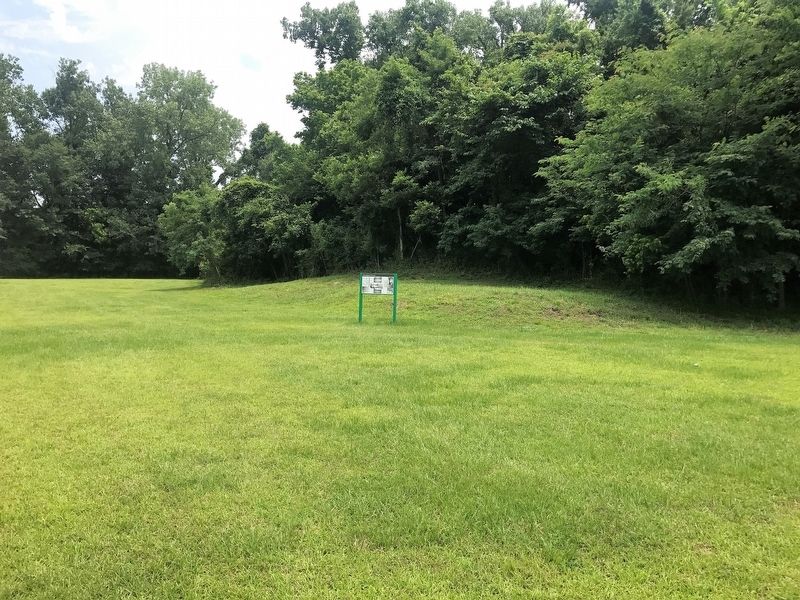
Of the six mounds identified on the early 18th-century maps of the Grand Village, three remain. Mound A is now eroding into St. Catherine Creek. Mound B is a pyramidal platform mound, roughly seven feet tall, built in four stages. Each stage served . . . — — Map (db m103758) HM
Near Jeff Davis Boulevard near South Temple Road, on the right when traveling east.
The Natchez Indians used the open area between the Great Sun's Mound and the Temple Mound for religious and social ceremonies. In 1725, the funeral ceremonies for the Tattooed Serpent, brother of the Great Sun, were held on this plaza.
Le Page Du . . . — — Map (db m110549) HM
Near Jeff Davis Boulevard north of South Temple Road, on the right when traveling north.
Eyewitness accounts of American Indians using ceremonial mound centers are very rare. In 1704, French colonists witnessed the funeral rites for a female Natchez chief at the Grand Village. The Natchez held a similar funeral ceremony here in 1725 . . . — — Map (db m114668) HM
Near Jeff Davis Boulevard south of South Temple Road, on the right when traveling north.
The Natchez chief called the Great Sun lived in a house on Mound B. The Jesuit missionary Pierre- François-Xavier de Charlevoix wrote that the Natchez houses were square or rectangular in floor plan with mud walls plastered on a wooden frame. Roofs . . . — — Map (db m114666) HM
Near S. Canal Street, 0.2 miles north of John R. Judkin Drive (U.S. 84), on the left when traveling north.
Here passed, in 1543, De Soto’s men under Moscoso. In 1682 La Salle and De Tonti here visited the Natchez Indians. In 1716 Bienville here built Fort Rosalie and established a French settlement. In 1763 the fort was ceded to the English and renamed . . . — — Map (db m87167) HM
Near Jeff Davis Boulevard near South Temple Road, on the right when traveling north.
In 1972, archaeologists found evidence of several Natchez Indian houses in this area. In some cases, house floors were superimposed on one another indicating repeated use of these locations. The excavations revealed two different types of houses . . . — — Map (db m114671) HM
On Lissie Street, 0.2 miles north of Liberty Road, on the right when traveling north.
After the American Revolution, frontiersmen from the Ohio Valley carried their products down stream to Spanish controlled New Orleans and Natchez.
Returning home, boatmen followed a series of Indian trails from Natchez to Nashville—trails . . . — — Map (db m87224) HM
Near Jeff Davis Boulevard south of South Temple Road, on the right when traveling east.
In the early 1700s, a road began here and connected the Grand Village with the French colonial settlement on the Mississippi River bluff near what is now downtown Natchez.In 1723, French mapmaker Ignace Broutin produced a remarkably detailed map of . . . — — Map (db m111076) HM
In the early 1700's, French colonists established a plantation called the "St. Catherine Concession" on this creek about two miles upstream from the Grand Village. The name was applied to the creek during the French colonial period in the Natchez . . . — — Map (db m106308) HM
On South Canal Street near John R. Junkin Drive (U.S. 84/425), on the right when traveling south.
The Natchez tribe of American Indians lived in the Natchez bluffs area along the lower Mississippi River valley.
Archaeological evidence shows them in the region as far
back as 700 CE. A sedentary people, the Natchez lived in
nine . . . — — Map (db m137690) HM
On Canal Street near Green Street, on the right when traveling south.
English Early on the morning of November 28th, 1729, a group of 30 Natchez Indians with their
hereditary chief, the Great Sun, arrived at Fort Rosalie armed with muskets and announced
their plan to brinq meat back to the French from their . . . — — Map (db m138006) HM
On N. Broadway Street, on the left when traveling north.
Marked by the Daughters of the American Revolution in Mississippi 1909.
This historic thoroughfare from Natchez to Nashville, Tenn. was used as a mail route in 1796.
Although it was a well known Indian trail in far earlier days. — — Map (db m4555) HM
Near Jeff Davis Boulevard near South Temple Road, on the right.
The Mississippi Department of Archives and History sponsored digs at the Grand Village in 1930, 1960 and 1972. The 1930 excavations employed WPA laborers to investigate mounds B and C. The archaeologists discovered that the Natchez built these . . . — — Map (db m114512) HM
Near Natchez Trace Parkway (at milepost 8.7), 0.5 miles U.S. 61, on the right when traveling north. Reported missing.
(Marker #1)
A National Road
Natchez in the extreme south-western corner of the United States was threatened by Spain in 1800 and later by France and Great Britain.
President Jefferson in 1801 decided that a road from Nashville . . . — — Map (db m87267) HM
On Emerald Mound Road, 1 mile west of Natchez Trace Parkway, on the right when traveling west.
Around 800 years ago, native peoples in this region began to transform a natural hill into what we call Emerald MoundThey followed a visionary plan and built this flat-topped sacred mound over perhaps 300 years. Covering eight acres, this . . . — — Map (db m108887) HM
On Emerald Mound Road, 1 mile west of Natchez Trace.
Emerald Mound was the product of a complex society organized to serve and sustain the welfare of its people beginning eight centuries ago. Life revolved around family relationships and well understood rules. An elite family, the Suns, held special . . . — — Map (db m115638) HM
Near Emerald Mound Road, 1 mile west of Natchez Trace Parkway, on the right when traveling west.
Before you is the second largest temple mound in the United States. Only Monks Mound in Cahokia, Illinois, is larger. This eight acre mound, constructed from a natural hill, was built and used from about 1300 to 1600 by the Mississippians, . . . — — Map (db m61974) HM
Near Emerald Mound Road, 1 mile Natchez Trace Parkway, on the right when traveling west.
Before you is a 30 foot secondary mound on which once stood a temple containing sacred Indian images.
Archeological evidence indicates that at least two small mounds stood along the North and South sides of the primary platform. These mounds . . . — — Map (db m87272) HM
On Emerald Mound Road, 1 mile west of Natchez Trace Parkway, on the right when traveling west.
Covering roughly eight acres, Emerald Mound is the second largest Mississippian mound north of Mexico. The main platform was constructed in three stages beginning ca. AD 1350. Archaeological excavations have confirmed that the first and second . . . — — Map (db m97256) HM
On U.S. 61 near Natchez Trace Parkway, on the right when traveling north.
Deep cut here is part of famed Indian trail taken over by U.S., 1803. Until the coming of steamboats, it was post route, & chief artery of travel between Natchez & Nashville. — — Map (db m143324) HM
On Emerald Mound Road, 1 mile west of Natchez Trace, on the right when traveling west.
Trade, art, and ideas linked Emerald Mound, both physically and spiritually, with mound sites throughout the eastern half of North America. Mound building, as a practice, was widespread. Over thousands of years, the native peoples who built mounds . . . — — Map (db m115945) HM
On Emerald Mound Road, 1 mile west of Natchez Trace, on the right when traveling west.
Emerald Mound's size is impressive. Scholar James Barnett Jr. called it the region's "crowning mound-building achievement" of the Mississippian era (1,150 to 300 years ago). only a complex society mobilized for a massive multi-generational project . . . — — Map (db m115946) HM
On Foster Mounds Road, 0.5 miles south of Steam Plant Road, on the right when traveling north.
Foster Mounds consists of two mounds located on either end of a large village or plaza. Mound A was built in four stages during the Plaquemine Period, sometime after AD 1400. Its original size and shape have been modified to accommodate the late . . . — — Map (db m105230) HM
On N. Polk Street (State Highway 145) at Woodlawn Drive, on the right when traveling north on N. Polk Street.
Founded in 1879 by the Milton B. Henry family on land sold by the Chickasaws to the U.S. government in 1832. Henry purchased 160 acres in 1856. Robert Henry Young, an infant grandson of M.B. Henry, was the first person buried here. The Henry . . . — — Map (db m66591) HM
On West Washington Street (Business Mississippi Route 12) west of North Jackson Street, on the left when traveling west.
Founded 1833; named after Chateaubriand's Indian heroine. Buried in county are 1st senator, Gordon Boyd, and 1st representative, Wm. Dodd, who named the county seat after Thaddeus Kosciusko. — — Map (db m140800) HM
On Mississippi Route 1 north of Clark Place, on the right when traveling north.
Christmas Mound is a single conical mound
approximately ten feet in height. Archaeological
excavations in 2013 determined that the mound was built
in a single stage on top of an earlier midden deposit. The
midden dates to ca. AD 400, but the . . . — — Map (db m173987) HM
On U.S. 82 at Lexington Street, on the right when traveling west on U.S. 82.
Northwest 9 miles is site of plantation mansion of Greenwood Leflore, chief
of Choctaws, statesman and planter. Home burned, 1942. His grave is near the site. — — Map (db m170285) HM
Near Natchez Trace Parkway (at milepost 232.4), 2.6 miles north of Mississippi Highway 8, on the right when traveling north.
(Marker #1)
Prehistoric Trade
Raw materials and articles from distant areas reached the Indians of the Bynum site by trade along trails that were the forerunners of the Natchez Trace.
Spool-shaped objects made of . . . — — Map (db m84830) HM
On N. Jackson Street at E. Madison Street, on the right when traveling north on N. Jackson Street.
This monument marks the Natchez Trace through Chickasaw County. By the Treaty of Pontotoc in 1832, the Chickasaw Indians ceded to the United States their lands east of the Mississippi. In 1801-1802 the old Indian trail was converted into a wagon . . . — — Map (db m97567) HM
Near County Road 413, 2.5 miles west of Natchez Trace Parkway, on the right when traveling west.
The first archaeological work at Owl Creek Mounds was supervised by Moreau Chambers in August, 1935. He was employed by the Mississippi Department of Archives and History and assisted by Slater Gordon. E.T. Winston, a Pontotoc journalist and local . . . — — Map (db m84697) HM
Near County Road 413, 2.5 miles west of Natchez Trace Parkway, on the right when traveling west.
In the summers of 1991 and 1992, archaeology field schools from Mississippi State University worked to learn more about the site. Most of the excavations were done on top of Mounds I and II, with small test units dug into Mounds III, IV, and V. . . . — — Map (db m84698) HM
Near County Road 413, 2.5 miles west of Natchez Trace Parkway, on the right when traveling west.
Owl Creek Mounds were built between 800 and 900 years ago and were used for only about 100 years. This was determined by the dating of charcoal samples collected at the site and by studying the artifacts and type of building remains found in the . . . — — Map (db m84699) HM
Near County Road 413, 2.5 miles west of Natchez Trace Parkway, on the right when traveling west.
Hernando De Soto landed in Florida at Tampa Bay in May, 1539. His army numbered around 800 Spaniards including two women. He also had 240 horses and several pigs. The expedition traveled through the Southeast to Texas and returned to the Mississippi . . . — — Map (db m84690) HM
Near County Road 413, 2.5 miles west of Natchez Trace Parkway, on the right when traveling west.
The first humans came to North America by crossing the Bering Strait land bridge, which connected Siberia and Alaska. Their descendants arrived in this part of Mississippi nearly 12,000 years ago. The oldest mounds in the state were built by people . . . — — Map (db m84696) HM
On County Highway 413, 0.3 miles east of County Highway 124, on the left when traveling east.
Born circa 1760, William Colbert was a notable Chickasaw warrior. He fought in the American Revolution and beside Piominko in the 1790s. George Washington appointed him a major general in 1795. In 1813, William helped the Americans fight the Red . . . — — Map (db m155285) HM
On Park Lane Drive south of Adams Avenue, on the left when traveling north.
Founded as Rose Hill 1845. Chartered as Okolona 1850. Named for Chickasaw Indian brave. Scene for three Civil War battles. First Mississippi Cavalry, C.S.A., was organized and equipped here. — — Map (db m102748) HM
On East Monroe Avenue (Mississippi Route 41) east of South Carter Street, on the right when traveling west.
Founded as Rose Hill 1845. Chartered as Okolona 1850. Named for Chickasaw Indian brave. Scene for three Civil War battles. First Mississippi Cavalry, C.S.A., was organized and equipped here. — — Map (db m102749) HM
Near Natchez Trace Parkway (at milepost 193.1), 2.4 miles south of Mississippi Highway 9.
(Marker #1)
The Great Eastern Hardwood Forest
Before Columbus, the world of the eastern Indian was one of a vast continuous forest stretching from Canada to the Gulf coast. A mature forest, it changed little over the centuries, and . . . — — Map (db m87480) HM
On Natchez Trace Parkway (at milepost 180.7), 0.1 miles south of Mississippi Highway 413, on the right when traveling north.
Louis Leflore first traded with the Choctaw Indians at a bluff now part of Jackson Mississippi. About 1812 he established his stand 900 feet to the northeast on the Natchez Trace.
Because of the storekeepers nationality, the area was often . . . — — Map (db m87485) HM
On Natchez Trace Parkway (at milepost 203.5), 0.6 miles south of U.S. 82, on the right when traveling north.
Pigeon Roost Creek, to your left, is a reminder of the millions of migrating passenger pigeons that once roosted in trees in this area. The species has been completely destroyed.
One mile east where the Natchez Trace crossed the creek, . . . — — Map (db m87484) HM
On Old Mill Road, 0.4 miles south of Bald Hill Road, on the right when traveling south.
Of the three original mounds overlooking Bayou Pierre, only one remains. A pyramidal platform, Mound A is currently 16 feet tall. Excavations indicate that Native Americans built the mound in multiple stages during the Coles Creek Period, from AD . . . — — Map (db m103785) HM
Near Natchez Trace Parkway (at milepost 45.7), 4.2 miles north of Mississippi Highway 18. Reported missing.
Excavation of this site tells us much about the people of the late prehistoric periods. The Plaquemine culture included the ancestors of the modern tribes of Mississippi and Louisiana. It was a society with elaborate agriculturally oriented . . . — — Map (db m87325) HM
On Rodney Road, 1.6 miles west of Montgomery Road, on the left when traveling west.
Windsor Mounds includes four rectangular platform mounds overlooking Bayou Pierre. Mound A, visible from the road, is the largest at over 30 feet, and has a ramp extending toward the east. Mounds B, C, and D range in height from 3 to 16 feet. The . . . — — Map (db m103783) HM
On Alternate U.S. 45, 0.4 miles south of Truman Creek Road, on the right when traveling north.
Excavated June 1934 by
Mississippi Department of Archives and History
Dunbar Rowland, LL.D., Director
Jordan B. Chambers, Archeologist
— Marked 1934 by —
Horseshoe Robertson Chapter
Daughters of the American . . . — — Map (db m107820) HM
On Alternate U.S. 45, 0.4 miles south of Truman Creek Road, on the right when traveling south.
Marked 1934 by
Israel Miller Society
Children of the American Revolution
— Members —
{Listing of members and titles}
Built by A.J. Pearson & Sons — — Map (db m107821) HM
On Alternate U.S. 45, 0.5 miles south of Truman Creek Road, on the right when traveling north.
Constructed ca. 100 B.C.-A.D. 400 for the burial of high-status members of an unknown local tribal group. An associated village site lies across the highway to the Southwest. — — Map (db m107534) HM
On Sunflower Avenue at 1st Street, on the right when traveling south on Sunflower Avenue.
Founded 1868 at crossing of Indian trails and on possible route of De Soto's expedition. Chartered 1882. Coahoma co-county seat, 1892; sole seat since 1936. Home of Gov. Earl Leroy Brewer. — — Map (db m89925) HM
On Coahoma-Rich Road, 0.9 miles south of U.S. 61, on the right when traveling south.
When first recorded, Salomon Mounds had three (possibly four) large platform mounds and as many as eight smaller mounds arranged around a central plaza. The smaller mounds have been plowed away, while one of the large mounds was destroyed in 1958 . . . — — Map (db m107621) HM
On State Highway 6, 0.5 miles east of Crum Road, on the right when traveling east.
The Dunn site consists of three earthen mounds. Mound A is oval in shape and just over sixteen feet in height. Mounds B and C have ben diminished by erosion and are less than three feeet in height. Archaeological excavations in 2013 indicate that . . . — — Map (db m154827) HM
On U.S. 51 south of West Commerce Street, on the right when traveling south.
The Europeans brought beads, metal bells,
horses, pigs and a variety of fruits and vegetables
to trade with the Southeastern Indians.
Beads and bells were the first items traded here
De Soto offered glass beads and metal . . . — — Map (db m170552) HM
On Norfolk Road, 0.1 miles east of Thomas Road, on the right when traveling west.
The Edgefield site consists of three conical earthen mounds arranged on a northwest-southeast axis. The two largest mounds are roughly 20 feet in height, while the third is just under ten feet. Much of the surrounding soil has been removed for use . . . — — Map (db m234537) HM
On Dubard Road (Mississippi Route 35) at Blanch Road, on the right when traveling south on Dubard Road.
Organized here in 1818 by
the Rev. Cyrus Kingsbury.
The 1st in a series of 13
missions for the education
of the Choctaws into western
culture, it was closed in 1832
due to removal of many
Choctaws to Oklahoma. — — Map (db m173979) HM
On Porte Avenue at Beach Boulevard (U.S. 90), on the right when traveling north on Porte Avenue.
A Trip through Biloxi's History
Archaeological artifacts and evidence prove the existence of prehistoric and historic Native Americans on the Biloxi peninsula long before the first French expedition. The name Biloxi, which means First . . . — — Map (db m161860) HM
On Central Avenue, 0.1 miles south of Bay Shore Drive, on the right when traveling south.
Long before the Europeans appeared on the Biloxi Back Bay
American Indians had trails that led to the water's edge, where
their canoes were beached for crossings. At the time Biloxi Bay
depths were incidental. That changed early in the . . . — — Map (db m122439) HM
On East College Street east of McLemore Drive, on the right when traveling east.
This stone marks the crossing of the Natchez Trace, pioneer highway of Mississippi Territory, blazed through the forest during the administration of Gov. W.C.C. Clairborne.
Over it marched the Tennessee troops to join Andrew Jackson in 1812. . . . — — Map (db m115391) HM
Near Natchez Trace Parkway (at milepost 93.1), 0.5 miles north of Medgar Evers Boulevard (U.S. 49), on the left when traveling north.
To improve communication to the Old Southwest, the Natchez Trace was declared a post road in 1800. Afterwards, with Choctaw permission, improvements to this section of the Old Trace began. In 1805, the Choctaw allowed inns, known as stands, to be . . . — — Map (db m87361) HM
Near U.S. 49, 8.8 miles north of Interstate 220, in the median.
Built and used between A.D 1000 and 1300, this platform mound and a nearby burial mound mark the ceremonial and political seat of a regional chiefdom of the Plaquemine culture. A thatched, clay-plastered ritual temple or chief's lodging stood atop . . . — — Map (db m77266) HM
On U.S. 49, 8.8 miles north of Interstate 220, in the median.
The Pocahontas site consists of two mounds and an
associated village area. Mound A is a rectangular platform
mound currently 20 feet tall, built between AD 750 and
1500. Excavations located structural features on the mound
surface, as well . . . — — Map (db m121103) HM
On Graymont Street at East Fortification Street, on the right when traveling north on Graymont Street.
Fortification Street is situated along a section
line from the 1820 Choctaw Cession that became
Jackson's northern city limit by act of
Mississippi's General Assembly in 1821. The area
was surveyed by U.S. General Thomas Hinds and
Judge Peter . . . — — Map (db m178435) HM
On U.S. 49 (U.S. 49) 0.8 miles south of Kennebrew Road, in the median.
Mississippi Mounds
Two main types of mound were constructed by American Indians in Mississippi: burial mounds and platform mouds. The Pocahontas archaeological site has one of each of these mounds. Mound A, which you see in front of you, is a . . . — — Map (db m152558) HM
Near U.S. 49, 0.7 miles south of Kennebrew Road, in the median.
Picture yourself standing at this spot, centuries ago, long before cars and highways
parking lots and interpretive trails. It is springtime. You stand in an Indian village
dotted with clay-walled houses; there is smoke rising from numerous . . . — — Map (db m121460) HM
Near U.S. 49, 0.8 miles south of Kennebrew Road, in the median.
Borrow Pits
At the Pocahontas site, dirt was dug in prehistoric times from
some areas, referred to by archaeologists as borrow pits, for two
uses. One was to fill in along the edges of a narrow ridge to
make a larger flat area where . . . — — Map (db m121443) HM
Near U.S. 49, 0.8 miles south of Kennebrew Road, in the median.
Midden Mounds
A midden mound is another type of "mound" frequently found
where American Indians once lived. Unlike ceremonial mounds,
midden mounds were not purposely constructed for a specific
use, but rather were created by the . . . — — Map (db m121445) HM
Near Highway 49, 0.7 miles south of Kennebrew Road, in the median.
The time during which American Indians lived at the Pocahontas site
can be split into two periods: the period before Mound A was built and
the period after. Before Mound A was built there appears to have been
a relatively large group of people . . . — — Map (db m121453) HM
Near Natchez Trace Parkway (at milepost 73.5), 5.4 miles south of Mississippi Highway 467, on the right when traveling north.
The Treaty of Doaks Stand, 1820, opened this land to white settlement. Land was quickly claimed, and pioneer families established themselves in this wilderness. William Dean and his wife Margaret settled near here on the Old Natchez Trace in . . . — — Map (db m87359) HM
On Natchez Trace Parkway (at milepost 61), 1.7 miles north of Fisher Ferry Road, on the left when traveling north.
(Left Panel)
Lower Choctaw Boundary
The line of trees to your left has been a boundary for 200 years. It was established in 1765 and marked the eastern limits of the Old Natchez District. This boundary ran from a point 12 . . . — — Map (db m87312) HM
On North Jackson Street (U.S. 51), on the right when traveling south.
Founded, 1858. Named for Louis Durant, a nearby Choctaw chief. Lockhart's Store, 4 mi. W., was first Holmes County post office, dating from 1849. Town later merged with Durant. — — Map (db m140836) HM
On Court Square (Mississippi Route 12/17) south of Oak Street, on the left when traveling south.
Created by an act of the legislature on 2/19/1832.
Because Gov. Scott opposed the creation of the new
county, a two-thirds vote of the legislature was necessary
for approval. Originally, part of a vast territory known as
Hinds County, which was . . . — — Map (db m184579) HM
On Martin Luther King Drive (U.S. 49E) at East Main Street, on the right when traveling north on Martin Luther King Drive.
Settled by Charles Land, 1826. Early settlers came by Rockport Road, built by Indians from Tchula Lake to Natchez Trace. Town was trade & shipping center for planters of this area. — — Map (db m121048) HM
On Mississippi Route 7, 0.5 miles south of Smith Road, on the right when traveling south.
Jaketown is the site of some of the earliest Indian earthworks
in Mississippi. Of eighteen mounds recorded, only Mounds
A, B, and C are still visible. The earliest stages of Mound A
were built in the Late Archaic/Poverty Point Period . . . — — Map (db m235137) HM
On Mississippi Route 7 north of Fishco Road, on the left when traveling north.
A significant archaeological site initially settled by people of the Poverty Point culture ca. 1000 BC and continuously occupied through all subsequent archaeological periods of the Lower Miss. Valley. — — Map (db m121110) HM
On Grace Road, 0.3 miles west of State Highway 1, on the left when traveling south.
Of the five original mounds located on the eastern bank of Steele Bayou, only Mounds A and B survive. At 40 and 16 feet respectively, Mounds A and B were built using a technique called basket loading. Archaeological excavations found evidence of at . . . — — Map (db m154734) HM
On Deer Creek Road, 1.6 miles east of U.S. 61, on the right when traveling east.
Aden Mounds consists of three mounds surrounding a rectangular plaza, the fourth side open to Jeff Davis Bayou. Mounds A and B are rectangular platform mounds nearly 10 feet in height. Mound C is no longer visible, but archaeologists discovered its . . . — — Map (db m154464) HM
Near Interstate 22, on the right when traveling west.
The territory of the Chickasaw Nation
once included north Mississippi, west
Tennessee, northwest Alabama, and western
Kentucky. Until removal from Mississippi,
the Chickasaw people defended their
homeland from native invaders and
Europeans, . . . — — Map (db m169990) HM
On Barracuda Dr., 0.2 miles south of Graveline Rd, on the right when traveling south.
The nearby earthen mound was built by prehistoric Indians during the Late Woodland Period between 400 and 700 A. D. The mound's flat summit was used for ceremonial purposes. Listed on the National Register of Historic Places, it is one of the few . . . — — Map (db m129007) HM
On Iberville Drive east of Ames Avenue, on the right when traveling west.
Site probably used by Indians. Was most popular for medicinal properties from 1850s until 1920. Also known as 'Mineral Springs' and the best known nationally of Mississippi's many mineral spring resorts. — — Map (db m102206) HM
On Beach Boulevard, 0.1 miles east of Westwood Street, on the right when traveling east.
Camp Twiggs was named in honor of Army General David E. Twiggs, the commanding general of the Western Division, the geographical area of the southeast U.S. in 1849. Twiggs replaced Zachary
Taylor when Taylor was elected President in November, 1848. . . . — — Map (db m102359) HM
On State Highway 15, 0.1 miles north of Commerce Drive, on the left when traveling north.
One of routes of military & post road begun, 1807, from Natchez to Ft. Stoddert & Milledgeville, Ga. Over this trail many immigrants came into Territory & here Sam Dale operated wagon train. — — Map (db m56544) HM
On Medgar Evers Boulvard east of Main Street, on the right when traveling east.
Home 4 mi. W. His cavalry "pride" of one army & "admiration" of other at N. Orleans, 1815. Militia head, 1815-19; comr. in negotiating Choctaw cession, 1820 & selecting site of capital at Jackson, 1821; mem. legislature & Congress. — — Map (db m105207) HM
On Mississippi Route 16W at Main Avenue, on the right when traveling east on State Route 16W.
Once Indian village ruled by "Little Leader," Hopiah Iskitina. Named for Baron Johann DeKalb of American Revolution, who came to U.S. with Lafayette. Town chartered Dec. 23, 1833. — — Map (db m140657) HM
On Old Taylor Road (County Road 303) south of County Route 3062, on the right when traveling south.
Buried here between 1837 and 1865 are early settlers of Lafayette Co. Among these is the grave of John J. Craig, purchaser of the Indian lands that are now Lafayette Co. and donor of the site of Oxford. — — Map (db m102979) HM
On Courthouse Square at East Jackson Avenue, on the right when traveling north on Courthouse Square.
Chartered in 1836 on Chickasaw cession land, Oxford was named for the university town in England and became home to the University of Mississippi in 1848. During the Civil War, Generals Grant and Sherman met in Oxford (1862), and the Square and many . . . — — Map (db m102878) HM
On Hillview Drive (Old State Highway 39) at John C Stennis Drive, on the right when traveling north on Hillview Drive.
Now Lizelia. Named for Sam Dale, famous scout & hero of “Canoe Fight”, War of 1812. Guided Choctaws to Oklahoma. Died here, 1841. Grave is 2 mi. west in Old Cochrane Cemetery. — — Map (db m179049) HM
On KOA Campground Road, 1.5 miles west of Will Garrett Road, on the right when traveling west.
One mile N. is buried Timothy Pigford's widow, Elizabeth Wells, & others of her family. She moved from Duplin Co., N.C. about 1832 to lands ceded by the Choctaw Nation in the 1830 Dancing Rabbit Creek Treaty. — — Map (db m173398) HM
On Natchez Trace Parkway (at milepost 140) at Red Dog Road, on the left when traveling north on Natchez Trace Parkway.
The road to your left, running to Canton, Mississippi, was opened in 1834 and named for Choctaw Indian Chief Ofahoma or Red Dog. Like other Choctaw, he had accepted the way of his European neighbors and had become a farmer.
Chief Ofahoma . . . — — Map (db m87488) HM
Near Ripley Road (County Route 370) 0.5 miles north of Bethany Road (County Route 370), on the right when traveling west.
Long before Civil War soldiers fought at this site in 1864, this land was part of the Chickasaw Nation. Tishomingo, whose name derived from the Chickasaw title tishu minko meaning "speaker for the chief" or "assistant chief" in the Chickasaw . . . — — Map (db m61924) HM
On County Road 503, 1.9 miles south of County Road 833, on the right when traveling south.
Tishomingo is the English
spelling of his Chickasaw title,
Tisho Minko. It translates as
assistant chief but signifies that
he was a great warrior
and orator. Tishomingo led
warriors by example, reputation
and his powers of persuasion.
He . . . — — Map (db m185658) HM WM
On Bethany Road (State Highway 370) 0.4 miles east of County Route 833, on the right when traveling east.
In 1832, this area ceded from the Chickasaw Nation to the United States by the Treaty of Pontotoc and became part of the State of Mississippi. According to the treaty, the land was surveyed and offered for sale by the Federal Government. The . . . — — Map (db m91177) HM
On Pierce Street at President Avenue, on the right when traveling east on Pierce Street.
Near here, on May 26, 1736, French and Choctaw invaders under Bienville were soundly repulsed by Chickasaws defending the Ackia, Apeony, and Chukafalaya villages. Many French casualties occurred. — — Map (db m102783) HM
Near Natchez Trace Parkway (at milepost 261.8), 0.5 miles south of McCullough Boulevard (Mississippi Highway 178), on the left when traveling north.
(Marker #1)
A Chickasaw Village
Here once stood an Indian village of several houses and a fort.
Summer House
During the summer they lived in rectangular well-ventilated houses.
Winter House
In the winter . . . — — Map (db m84809) HM
Near Natchez Trace Parkway (at milepost 263.9) north of U.S. 78.
This monument marks a stage in the course of the Natchez Trace through Mississippi. Over this first high-road came a tide of the best population of the older Southern states seeking homes in the Southwest. After the Treaty of Pontotoc, Oct. 20, . . . — — Map (db m84800) HM
Near Natchez Trace Parkway (at milepost 263.9) north of U.S. 78.
In the early 1800's ordinary Americans could not be bothered with learning the names of Chickasaw villages on the Natchez Trace. One they called Old Town, and passed the name on to the stream running through this valley. It is one of the sources of . . . — — Map (db m84799) HM
Near Old West Point Road, 0.7 miles north of Plymouth Bluff Access Road, on the right when traveling north.
6 mi. N. at mouth of Tibbee and ford in Tombigbee is site of old Indian village, fort, and cotton trading center. Incorporated 1836, but declined with river trade. Now a wilderness.
(supplement)
This sign was originally posted (1952) . . . — — Map (db m178939) HM
Near Old West Point Road, 1.3 miles north of Plymouth Bluff Access Road, on the right when traveling north.
The large tree that you see here is known by several common names, including Osage orange and hedge apple. We will use a colloquial name, Bodock (bodark), based upon the original French name, bois d’arc (wood of the bow). The Osage Indians made . . . — — Map (db m178982) HM
170 entries matched your criteria. The first 100 are listed above. The final 70 ⊳