On 4th Street NE (U.S. 14) at Jersey Avenue NE, on the right when traveling east on 4th Street NE.
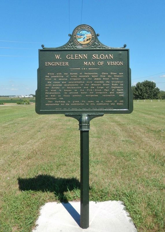
While with the Bureau of Reclamation, Glenn Sloan saw the possibility of using mountain water from the Missouri River to develop irrigation in the James River Valley.
His vision and determination made possible the broadened multi-purpose . . . — — Map (db m123908) HM
Lewis and Clark
The Lewis and Clark Expedition, officially the Corps of Discovery, was in what is now South Dakota from August 21 to October 14, 1804 and from August 21 to September 4, 1806.
While here they would make numerous . . . — — Map (db m213911) HM
Legend of the Separation of the Lakes
See the narrow waterway between two peninsulas? How do you think it was formed?
A poem written by Professor A.B. Crane offers one explanation. He tells of an American Indian chief who pledged his . . . — — Map (db m179792) HM
Breastworks
Probably built by two companies of the 2nd Infantry, under command of Capt. D. Davidson, in June-July, 1859. Parapets were then about 5 ft. high. A log house once stood in the center, but was razed long ago for firewood. Cannon . . . — — Map (db m179795) HM
Millennium ago, migrating bison herds grazed the tall grass. Ducks, geese and other birds nested in the sloughs, and fish were found in abundance in the lakes and streams in this area known as the Coteau des Prairies.
With all this . . . — — Map (db m179698) HM
Near Oakwood Drive, 1.7 miles north of 204th Street (County Highway 6).
The Oakwood Lakes chain was formed more than 10,000 years ago when melting glaciers filled depressions scooped from the earth's surface. The eight lakes, fertile lands and native woods attracted prehistoric Indians. Burial mounds in the park are . . . — — Map (db m237234) HM
Near Oakwood Drive, 1.7 miles north of 204th Street (County Highway 6).
Scout Island was named for the annual Boy Scout encampment once held here. The island is now a peninsula bordered on the east and south by Tetonkaha Lake and on the west by Johnson Lake.
At the flagpole is a plaque dedicated to D.C. Mackintosh, a . . . — — Map (db m237236) HM
Near Oakwood Drive, 1.7 miles north of 204th Street (County Highway 6).
From this vantage point, you can see the land formations described by explorer Joseph N. Nicollet and John Fremont when they camped at Oakwood Lakes in 1838. In Nicollet's words, "Wood is less scarce here. It is on all the tongues of land which . . . — — Map (db m237248) HM
Near Oakwood Drive, 1.7 miles north of 204th Street (County Highway 6).
Captain DeLozier Davidson and his soldiers from Fort Randall constructed this military fort in 1859. It served as a supply post for Fort Wadsworth, now called Fort Sisseton. Soldiers manned the fort, also called a breastwork, until December 1864 . . . — — Map (db m237191) HM
On South Lake Drive east of 456th Avenue (County Highway 2), on the right when traveling east.
The region between Lake Poinsett and Oakwood Lakes was a summer hunting area for the Sioux for over one hundred years. The Sioux who frequented the area used various names for the different features in this area.
* Oakwood Lakes was . . . — — Map (db m238363) HM
On 211th Street (U.S. 81) 1.1 miles west of Caspian Avenue, on the right when traveling west.
Oakwood Lakes, called by the Sioux, Te-tonka-ha, meaning the place of the Great Summer Lodge, lie in a scenic state park 7 miles N and 3 W. First visitors of record were Nicollet & Fremont. July 8, 1838.
During the Indian Disturbances of . . . — — Map (db m179802) HM
On 197th Street, 15 miles east of U.S. 29, on the right when traveling west.
Lake Hendricks Norwegian Colony of 1873
The first settlers at Lake Hendricks were 31 Norwegians, arriving July 14, 1873, with 11 covered wagons and 30 cattle. On May 14, 1873 they left Houston County, Minn., and Allamakee and Winneshiek . . . — — Map (db m179811) HM
On Unnamed Road, 0.7 miles north of 201st Street, on the right when traveling north.
Lake Hendricks State Park
This lake was named for Thomas A. Hendricks (1819-1885), Commissioner of the General Land Office, 1855-59, at which time the state boundary was surveyed and the lake named. Hendricks was a Member of Congress, 1851-55; . . . — — Map (db m184234) HM
On Sand Lake Dr., 0.2 miles east of County Highway 16, on the right when traveling east.
Perhaps our best known group of birds, waterfowl species such as ducks, geese and swans have webbed feet and water repellent feathers that allow them to float and swim easily. Often striking in plumage, waterfowl are found in a variety of watery . . . — — Map (db m102937) HM
On 396th Ave., 0.8 miles 120th St., on the right when traveling north.
A Wetland Enhancement Project Developed by Ducks Unlimited, Inc. in cooperation with the U.S. Fish and Wildlife Service and the North American Wetlands Conservation Act Council on Sand Lake National Wildlife Refuge to improve North America's . . . — — Map (db m103078) HM
Sand Lake National Wildlife refuge, a 2,498 acre refuge, was established in 1935 to protect critical nesting and migrating habitat for our nation's waterfowl. The James River, which flows through the refuge, was dammed by the Civilian Conservation . . . — — Map (db m102938) HM
WEST
Looking to the west, the giant Canada goose pens and display pool are below you. In the spring and summer, you'll see the giant Canada geese raising their goslings in the area. Just beyond the goose area is the tree-lined Refuge . . . — — Map (db m103079) HM
When the Corps of Discovery reached present-day Chamberlain on September 16, 1804, they were ready for a break. Since May, one member of the expedition, Sergeant Charles Floyd, had died, possibly of appendicitis. Another, Private George Shannon, . . . — — Map (db m98240) HM
South Dakota's State Capitol is located in
Pierre, a city that sits along the banks of
the Missouri River near the Oahe Dam. The
building was completed in 1910 and restored
in 1989. The grounds feature Capitol Lake
surrounded by memorials to . . . — — Map (db m161873) HM
Near State Highway 50 south of Thunder Road, on the right when traveling south.
This spot offers a spectacular view of the Missouri River, but the river is much different today from when Lewis and Clark traveled up it. Several huge dams now control its flow.
When the expedition came through, the river could go from a mere . . . — — Map (db m242480) HM
On State Highway 47 north of Lower Road, on the right when traveling south.
A Crow Creek Sioux dancer at a powwow.
Courtesy of South Dakota Public Broadcasting
The Crow Creek Reservation began in a tragic story of hardship. The Uprising, or the U.S. – Dakota War, started in 1862 when starving Dakota . . . — — Map (db m242476) HM
On State Street (Business U.S. 212) just east of 8th Avenue, on the left when traveling east.
From this location you are able to view the “Beautiful Forks” of the Redwater River as it runs into the Belle Fourche River as named by French explorers as they passed through the area over 200 years ago. Of course, “Belle Fourche” (pronounced . . . — — Map (db m234799) HM
On State Highway 1804 at 294th Ave, on the right when traveling west on State Highway 1804.
Old Pollock
In 1901 Pollock was founded as the end point of the Soo Line rail service from Wishek, ND. Soo Line officials requested the town be named Pollock in honor of R.Y. Pollock, a pioneer lay minister and respected citizen of the . . . — — Map (db m112084) HM
On U.S. 18, 0.7 miles west of Lewis Avenue, on the right when traveling west.
Fort Randall Dam
Construction Period: 1946-1956
Length: 10,700 ft
Width at Base: 4,300 ft
Max. Height: 165 ft
Type: Rolled Earth Fill
Earth Fill: 50 million cu yds
Concrete: 961,000 cu yds.
Record Discharge: 169,800 cfs (July . . . — — Map (db m187549) HM
Our National Symbol
In 1782, over 200 years ago, the United States adopted the bald eagle as our national symbol. This majestic, white-headed bird, soaring freely throughout our continent, was a common sight to our ancestors.
Today, the . . . — — Map (db m234977) HM
The Omaha and Ponca
The Omaha and Ponca tribes were once a single people closely related to the Osage, Kansa and Quapaw tribes of the lower Missouri and Mississippi River valleys. The ancestoral Omaha-Ponca people migrated from that region . . . — — Map (db m234981) HM
Basin
Many thousands of years ago a great continental ice sheet advancing from the northeast onto the northern plains blocked or reversed the flow of all rivers it came into contact with. The result of this titanic natural force was the . . . — — Map (db m234980) HM
Near South Dakota Street, 1.5 miles south of U.S. 50, on the right when traveling south.
The Missouri River flowed beneath the bluff when Meriwether Lewis and William Clark led the Corps of Discovery on their epic journey. The mouth of the White Stone River was then near this site at Cotton Park. Now known as the Vermillion River, its . . . — — Map (db m179205) HM
Near South Dakota Street, 1.5 miles south of State Route 50, on the right when traveling south.
Lewis and Clark
The Lewis and Clark Expedition, officially the Corps of Discovery, was in what is now South Dakota from August 21 to October 14, 1804 and from August 21 to September 4, 1806.
While here they would make numerous . . . — — Map (db m187536) HM
On State Highway 19, 0.1 miles north of 312th Street, on the left when traveling north.
The Missouri National Recreational River preserves two splendid segments of the free-flowing, once unpredictable "Big Muddy." These natural-appearing reaches are reminiscent of the river as reported in the journal pages of captains Lewis and Clark . . . — — Map (db m194634) HM
On Canby Street, 1.3 miles south of State Route 50, on the left when traveling west.
Early Vermillion settlers built their homes and businesses below the bluff. The town was susceptible to flooding from the Missouri River, which at that time ran next to the bluff.
The winter of 1880 started early and did not subside until an . . . — — Map (db m179289) HM
On West Cherry Street, 0.5 miles south of State Route 50, on the left when traveling west.
Vermillion
August 24, 1804, Lewis & Clark camped near the White Stone (Vermillion) River and next day visited Spirit Mound 8 miles north. The military road, Sioux City - Ft. Randall after 1855 provided access, as did steamboats. A. C. Van Meter . . . — — Map (db m179392) HM
On South Dakota Street, 0.1 miles south of East Broadway Street, on the right when traveling south.
Lat 42° 46' 23.0" N
Long 96° 55' 51.0" W
From here the Water Trail follows five miles of the Vermillion River to its confluence with the Missouri River near River Mile 772, then continues down the Missouri nine miles to . . . — — Map (db m221312) HM
On South Dakota Route 20, 1 mile east of 462nd Avenue, on the right when traveling east.
During the Moon of the Harvest (August) in 1773 a band of Sioux were camped on the shore of this lake. We-Wa-Ke, fairest maiden in the camp had given her heart to a brave young warrior, Big Eagle, whose courage on the hunt and in battle far . . . — — Map (db m180984) HM
On South Gamble Street at East Hanson Avenue, on the right when traveling north on South Gamble Street.
Used for many years in White's mill on "Jim" River, 4 miles east of Mitchell, to grind flour for the homesteaders and farmers who hauled their wheat to the "grist" mill
In memory of my father
John R. White
and other pioneers of 1879 . . . — — Map (db m180133) HM
On Fall River Road (U.S. 385) near Hidden Nook Trail, on the right when traveling north.
Tribal tradition states that as long ago as the 16th century the Fall River Valley and canyon area were seldom without groups of tipis belonging to North American Plains Tribes. They knew the curative value of the warm springs located there and used . . . — — Map (db m184455) HM
Near U.S. 18 west of Toe Road West, on the right when traveling east.
Fort Randall Dam
Construction Period: 1946-1956
Length: 10,700 ft
Width at Base: 4,300 ft
Max. Height: 165 ft
Type: Rolled Earth Fill
Earth Fill: 50 million cu yds
Concrete: 961,000 cu yds.
Record Discharge: 169,800 cfs (July . . . — — Map (db m235027) HM
Near U.S. 18 west of Toe Road West, on the right when traveling east.
On the plain below stand the ruins of Fort Randall's chapel, the sole aboveground remains of a once bustling frontier post. Soldiers from Fort Randall—the U.S. Army's principal military and supply post on the Upper Missouri, 1856–92—protected . . . — — Map (db m235026) HM
Near Stone Church Drive east of Toe Road West, on the right when traveling east.
The quartermaster and commissary storehouse once stood on this spot. Quartermaster and Commissary Departments worked together to keep the fort supplied.
The quartermaster was responsible for the fort's uniforms, equipment, transportation, and . . . — — Map (db m188317) HM
Near U.S. 18 west of Toe Road West, on the right when traveling east.
The Missouri, the continent's longest river, figures prominently in the unfolding of America's saga. Flowing nearby in its 2,341-mile course from the Rocky Mountains to the Mississippi, the Big Muddy is not only loaded with sediment but steeped in . . . — — Map (db m235025) HM
Lat 43° 3' 15" N
Long 98° 33' 21" W
You are just downriver from Ft. Randall Dam, the first dam in South Dakota completed under the Pick-Sloan Plan by the US Army Corps of Engineers in 1956.
The Missouri River remains . . . — — Map (db m235011) HM
On 192nd Street (State Highway 28) near North Lake Drive, on the right when traveling west.
The Civilian Conservation Corps was a federal relief program during 1933-1942 that gave jobless men work renovating abused lands. The Army built 48
200-man camps in South Dakota and provided
food, clothing, medical care,
pay and programs . . . — — Map (db m202576) HM
On East 5th Street east of North Broadway (U.S. 14), on the right when traveling west.
Harlan J. Bushfield, born August 6, 1882 in Atlantic, Iowa, came to Miller in 1883. He earned his law degree from the University of Minnesota in 1904 and returned to Miller to practice law. In 1912, Bushfield married Vera Cahalan, a fellow Miller . . . — — Map (db m185466) HM
Near State Highway 1804, 1.6 miles north of Grey Goose Road, on the left when traveling north.
Lewis and Clark's stay in this area has been described as a "tense three days." The days with the Teton Sioux were filled with long periods of friendly visiting and good company but were also punctuated by isolated moments of trouble and . . . — — Map (db m223796) HM
Near Farm Island Road, 1 mile south of South Dakota Highway 34, on the right when traveling south.
The CCC camp was established on this island during the summer of 1933 and provided work for 250 men. Work project plans were twofold: to convert Farm Island into a state recreation area and to build an 850-foot causeway between the northwest point . . . — — Map (db m225030) HM
Near Parkwood Drive, 0.2 miles south of East Dakota Avenue, on the right when traveling south.
Welcome to Griffin Park! Griffin Park is located next to the Great Missouri, on which Meriwether Lewis and William Clark traveled during their Journey to the Pacific Ocean. Lewis and Clark's travels through this area have been considered as one of . . . — — Map (db m124870) HM
On Medicine Creek Road at South Dakota Highway 34, on the left when traveling north on Medicine Creek Road.
On September 22, 1804 Lewis & Clark passed by this river and camped a couple of miles up the Missouri. They called it Reuben River for Reuben Fields, one of their hunters. In 1839 however this was called Medicine Knoll River by Nicollet & Fremont, . . . — — Map (db m220071) HM
This portion of the Missouri River Valley has sparked the interest of archaeologists since 1895. Prehistoric sites along the river were excavated, mapped, recorded, and preserved. By the 1930s, aerial photography became an important tool for finding . . . — — Map (db m225028) HM
Near Farm Island Road, 1 mile south of South Dakota Highway 34, on the right when traveling south.
The State Division of Forestry supervised CCC men at the Farm Island camp. These hardworking men:
• Developed Farm Island Recreation Area
• Erected the Lewis and Clark monument (not accessible due to high water)
• Built the Arikara . . . — — Map (db m225032) HM
On State Highway 34 at milepost 233 at Chapelle Road, on the left on State Highway 34.
The partnership of Registre Loisel and Hugh Heney in 1802 set up a fur post on Cedar Island, within sight, about 5 miles down stream. Loisel was called Little Beaver by the Indians. This was part of Louisiana, receded by Spain to France in 1800 and . . . — — Map (db m219925) HM
On State Highway 34, on the left when traveling north.
Remnants of this historic trail can be seen just south of Hwy 34 along the ridge. In 1857 Nobles Trail was built by Col. W.H. Nobles, from Mendota (the mouth of the Minnesota) via Fort Ridgley to the Missouri River. It was to be a wagon road from . . . — — Map (db m180810) HM
On 437th Avenue at 209th Street, on the left when traveling south on 437th Avenue.
Erected
in memory of Christian pioneers
and founders of Lake Henry
community and Church
1878 — 1954
And this stone, which I have set for a pillar, shall be God's house–Gen. 28:22
whosoever thou art, enter on this ground with reverence . . . — — Map (db m209487) HM
On Territorial Road just south of U.S. 81, on the right when traveling south. Reported missing.
Lake Herman was the original stopping point on the Indian Trail that led from the pipestone quarries in Minnesota to the Three Rivers of the Sioux, a Sioux sanctuary near Fort Thompson on the Missouri. State Highway No. 34 closely follows this . . . — — Map (db m180136) HM
On Main Street at Violin Street, on the right when traveling south on Main Street.
Extending from the base of
Brown Rocks to the beginning of
present-day lower Main Street,
Elizabethtown was the first of many mining camps
established in Deadwood Gulch during the earliest days
of the gold rush. Named for Elizabeth Card, one of . . . — — Map (db m183219) HM
Whitewood Creek is a coldwater stream that flows from its headwaters in the high mountain valleys south of
Deadwood to its confluence with the Belle Fourche River northeast of the city of Whitewood. The creek drains a
44,756-acre sub-watershed of . . . — — Map (db m183280) HM
On CanAm Highway (U.S. 85) north of U.S. 385, on the left when traveling north.
After the inception of Deadwood's railroad system in 1890, rising flood waters and washouts became an ever growing threat to the mining camps in the northern Black Hills. Three significant washouts, caused by spring flooding, occurred at this . . . — — Map (db m121093) HM
On U.S. 14A, 6 miles south of Business 90, on the left when traveling south.
"But how it is that I've heard so little of this miracle and we, toward the Atlantic, have heard so much of the Grand Canyon when this is even more miraculous? All the better eventually… (that the Dakotas are not on the through line to the . . . — — Map (db m124130) HM
Near 480th Avenue (County Highway 135) 0.2 miles south of 269th Street (County Highway 102), on the right when traveling north.
As you look across the Big Sioux River and onto the landscape beyond, imagine clusters of hide-covered lodges and grass-covered mounds atop the terraces above the river. The smoke from village fires curls into the air and carries the scent of . . . — — Map (db m210637) HM
Near 480th Avenue (County Highway 135) 0.2 miles south of 269th Street (County Highway 102).
Brrrrrr! It would have been a chilly day 14,000 years ago. South Dakota was nearing the end of the last Ice Age and most of Lincoln County was covered by the eastern edge of a glacier, a massive sheet of ice that bulldozed across the landscape. . . . — — Map (db m244198) HM
On Business Interstate 90, 2 miles east of 339th Avenue, on the right when traveling east.
On Sept. 17, 1804, Lewis and Clark camped on the west bank below the Island and passing it on the 18th said: "Passed an Island about the middle of the river at 1 mile this island is about a mile long and has a great proportion of Red cedar on . . . — — Map (db m179941) HM
On State Highway 47, 4 miles south of 248th Street (County Road 6), on the left when traveling south.
White River has been so called since Perrin de Lac camped near mouth and met Cheyennes in 1802. 16 Sept. 1804 Sgt. Patrick Gass and Reuben Fields reconnoitering were at this point. — — Map (db m184643) HM
Flowing just north of here, Medicine Creek runs through the center of Lyman County, emptying into the Missouri River 27 miles (43 kilometers) to the northeast. The place-names of this Central South Dakota area read like an index to early state . . . — — Map (db m184639) HM
Near Adventure Drive east of North Drive, on the left when traveling east.
The dam was constructed and completed in 1958. Water flowed over the spillway for the first time on March 29, 1960, creating the lake. During this same time frame the Department of Game Fish and Parks purchased 1,540 acres of land to create the . . . — — Map (db m242213) HM
Near Adventure Drive east of North Drive, on the right when traveling east.
The Vermillion River was once known as Otter Stream. In 1801, a French trapper was the first person to reference the river on a map, referring to it as Otter Stream, presumably because of the abundance of otters. Lake Vermillion as we now know it . . . — — Map (db m242214) HM
In 1881 Frank and Justin Pettigrew began construction of the power dam and flour mill at this site where portions of the foundation remain. The mill and the railroad were the nucleus of the town which was first called St. Olaf, later called Keyes, . . . — — Map (db m222277) HM
On South Splitrock Boulevard (State Highway 11) 0.4 miles south of South Sioux Boulevard, on the right when traveling south.
In May of 1857, land speculators from the Dakota Land Company, of St. Paul, Minnesota Territory, surveyed and located the town site of Eminija in this immediate area. Eminija was the Santee Sioux Indian name for the Split Rock River . . . — — Map (db m198935) HM
Near South McHardy Road, 0.1 miles south of East Aspen Boulevard, on the right when traveling south.
The first Europeans to enter Minnehaha County in search of animal pelts to satisfy the demand abroad for furs may have been French trappers. Some historians believe that trader Charles Pierre Le Sueur, or his men, visited this area as early as 1683. . . . — — Map (db m198826) HM
Near South McHardy Road, 0.1 miles south of East Aspen Boulevard, on the right when traveling south.
Split Rock Creek is an unpretentious waterway that rises northeast of Ihlen, MN, and wanders through rich farmlands and quartzite walls until it joins the Big Sioux River approximately two miles southwest of this spot. In July 1879, this tranquil, . . . — — Map (db m198824) HM
On East 3rd Street at Washington Avenue, on the right when traveling east on East 3rd Street.
Minnehaha Co. - Population 2145 in 1965
Named after the dells and rapids of the Big Sioux River, which flows through the town and reminded settlers of the dells of the Wisconsin River. First surveyed in 1859 and sub-divided in 1864. . . . — — Map (db m208403) HM
Near South Cliff Avenue, 0.2 miles south of East 41st Street, on the right when traveling south.
After a strong coalition of civic organizations urged the city to build Falls Park and to set up a City Specification Committee within the Chamber of Commerce, such a study was conducted in 1967-68. The subsequent transformation of the appearance . . . — — Map (db m197452) HM
On Iverson Crossing Road, 0.4 miles west of 481st Avenue (State Highway 11), on the left when traveling west.
Long before bridges spanned the Big Sioux River, travelers and settlers forded the river at this location. Pioneer Ole B. Iverson, a Norwegian immigrant, homesteaded here in 1868 and "Iverson Crossing" became a common point of reference and a local . . . — — Map (db m199014) HM
USS South Dakota: 17 - 40mm Quad Mounts
Total - 68 Guns
Guns can be operated single fire or
Fully automatic - 120 rounds per minute
Basic gun crew for quad mount:
Mount Capt, Pointer, Trainer,
4-Loaders, 4-Ammunition Passers . . . — — Map (db m146020) HM WM
On 41st Street west of Riverview Avenue, on the right when traveling east.
Banning's Crossing takes its name from brothers Abraham, Richard and David Banning who settled near here on the east side of the Big Sioux River in 1876. The next year Abraham and David built a grist mill to grind locally grown wheat into flour. The . . . — — Map (db m199019) HM
On West 12th Street (State Highway 42) just west of South Kiwanis Avenue, on the right when traveling east.
[Marker Front]
On June 7, 1941, Vera Bushfield, wife of the governor of South Dakota, smashed a bottle of champagne against the towering bow of a new battleship and proudly proclaimed, “I christen thee South Dakota!” While an . . . — — Map (db m40516) HM
Near North Weber Avenue, 0.2 miles south of East Falls Park Drive, on the right when traveling south.
In the city's early days, the falls attracted both industry and pleasure seekers. During their leisure time, settlers and visitors enjoyed both the falls and Seney Island
The Island, as it was called by early residents, was an oasis for . . . — — Map (db m124198) HM
Mfr - Cramp Shipbuilding Co
Diameter - 17' - 6" Wt - 18.2 Ton
Bu. Eng. Serial No. 6304
USS South Dakota had two - 4 blade
inboard propellers and two - 5 blade
outboard propellers. Thrust from
the four propellers - 130,00 HP . . . — — Map (db m146035) HM
Near North Weber Avenue, 0.2 miles south of East Falls Park Drive.
(side 1)
The changing of global sea levels over millions of years was a major factor in determining the ancient geography of Minnehaha County. Through much of geologic time, salty warm-water seas covered the interior of the United . . . — — Map (db m124175) HM
Near North Weber Avenue, 0.2 miles south of East Falls Park Drive.
Various explorers may have visited the falls of the Big Sioux River in the 17th and 18th centuries, but there is no definite proof. An early State Historian, Doane Robinson, believed that Charles Le Sueur had visited the falls as early as 1683. . . . — — Map (db m198700) HM
This is one of the two hatches from the conning tower of the USS South Dakota.
Thickness - 16" Weight - 6,000#
The conning tower was located at 04 level which was about 35' above the main deck
Conning tower armor: sides - 16" Thick . . . — — Map (db m146024) HM
Near East 26th Street, 0.2 miles west of South Southeastern Avenue, on the right when traveling west.
This is the location of the historical Big Sioux River channel. This area, like many along the Big Sioux River's banks were very susceptible to seasonal flooding - predominantly caused by snowmelt runoff and by rainfall.
To improve the City's . . . — — Map (db m212171) HM
On West 57th Street north of Old Yankton Circle, on the right when traveling west.
A highland existed along the east side of South Dakota long before the Ice Age began two million years ago. Successive periods of glaciation deposited sediment across the highland and increased its elevation.
The last glaciation began 35,000 . . . — — Map (db m187261) HM
On West 12th Street at South Kiwanis on West 12th Street.
The vision of trying to obtain a 16" - 94 ton 62 ft long battleship gun barrel had it's beginning in November 1992. While Captain Witte, USNR (Ret), president of the Battleship Memorial Foundation was showing a Veterans Day guest speaker the . . . — — Map (db m146030) HM
This view of the lower level of the Hydroelectric plant shows the massive pipes that channeled the river's flow to three electric generators. Water entered the plant through the flume at the back of the room and flowed through the large gate . . . — — Map (db m112689) HM
The outline of this ship was erected by the officers and men of the Naval Reserve in cooperation with the Sioux Falls Bi-Centennial Commission, Sioux Falls Park Department and the Battleship Foundation. It is dedicated to the Officers and men who . . . — — Map (db m146017) WM
On West 57th Street north of Old Yankton Circle, on the right when traveling west.
This site has been an important Big Sioux River crossing for more than 300 years. As early as the 1700s the Yankton Sioux forded the river here and often made camp while en route to pipestone quarries in Minnesota.
After the slaying of Judge . . . — — Map (db m187262) HM
On East 8th Street east of North Phillips Avenue, on the right when traveling west.
This is the location of the first bridge to span the Big Sioux River at Sioux Falls. Built in 1876, the original bridge was washed out in the flood of 1881. The present bridge is an earth filled, three span arch bridge, which was considered an . . . — — Map (db m194903) HM
Near East 7th Street east of North Phillips Avenue, on the right when traveling east.
This is the location of the first bridge to span the Big Sioux River at Sioux Falls. Built in 1876, the original bridge was washed out in the flood of 1881. The present bridge is an earth filled, three span arch bridge, which was considered an . . . — — Map (db m194908) HM
Near East 8th Street, 0.1 miles east of North Phillips Avenue, on the right when traveling east.
As the lesser known of the original mills built in early Sioux Falls along the banks of the Big Sioux River, the Cascade Mill was built slightly before its bigger, more expensive, grandiose neighbor at the falls - The Queen Bee Mill. At half the . . . — — Map (db m194828) HM
Near East 7th Street east of North Phillips Avenue, on the right when traveling east.
The Cascade Milling Company, built in 1877 for E.A. Sherman and other investors, was located on the east bank of the river and north of the 8th Street bridge. The Company became the first to sell electricity in the city in 1885. An electric . . . — — Map (db m194907) HM
Near East 8th Street east of North Phillips Avenue, on the right when traveling east.
There were several flour mills and lumberyards along the early downtown riverfront. Railroads linked local suppliers with buyers across the Midwest but flooding and a lack of reliable river levels eventually led to a redevelopment of the area. . . . — — Map (db m195032) HM
Near North Cherapa Place south of East 6th Street.
Floods have been common along the Big Sioux River for hundreds of years. The combination of flat land, heavy snows, and spring rains can be disastrous. One of the most devastating floods occurred in 1881. The winter had been particularly harsh, . . . — — Map (db m124499) HM
On River Road, 0.1 miles north of East 10th Street (State Highway 42), on the right when traveling north.
This is the site of the earliest documented river crossing, used both by Native American peoples as well as Euro-American pioneers traveling the Yankton Trail. Prior to 1926, below the 9th Street Parking Ramp to the Northwest, a small island divided . . . — — Map (db m184843) HM
Near East 8th Street east of North Phillips Avenue, on the right when traveling east.
Early settlers embraced the Big Sioux River for its industrial potential, but the river was also an important recreational amenity
Bring your love to the bridge.
Initial, Attach & Kiss! #sflovelock
The Love Lock Wall
A love . . . — — Map (db m195025) HM
Near East 8th Street, 0.1 miles east of North Phillips Avenue, on the right when traveling west.
On May 13, 1912, during a flood of the Big Sioux River, four young Sioux Falls' men steered two crafts, a rowboat and a canoe, over the Cascade Mill dam. Guy Beck and Mat Yost successfully made the descent, but John Meehan and Will Dahl were thrown . . . — — Map (db m194702) HM
Near East 8th Street east of North Phillips Avenue, on the right when traveling east.
The combination of heavy snowfall and spring rains have been flooding the banks of the Big Sioux River for many years – these destructive events led to levee improvements and the reconstruction of downtown bridges & businesses. . . . — — Map (db m195034) HM
On North Phillips Avenue north of West 5th Street, on the right when traveling north.
The realization of a grand vision to restore the natural beauty of our city’s most historic and important landmark
Falls Park is the city’s historic birthplace. The almost mystical allure of the falls has always been a powerful influence. . . . — — Map (db m124588) HM
Near North Cherapa Place south of East 6th Street.
While the Big Sioux River was primarily of industrial importance to the settlement of Sioux Falls, it also has an equally important history for recreation.
The First Public Report of the Board of Parks Supervisors of 1915-1920 called for . . . — — Map (db m124495) HM
On River Road, 0.1 miles north of East 10th Street (State Highway 42), on the right when traveling north.
The Dakota Land Company of St. Paul, Minnesota, arrived in Sioux falls in June of 1857 as part of a "town-planting party" which was progressing from Medary (near Brookings, SD) to Commerce City (Canton) along the Big Sioux River. Because the prime . . . — — Map (db m184841) HM
134 entries matched your criteria. The first 100 are listed above. The final 34 ⊳