After filtering for South Dakota, 145 entries match your criteria. The first 100 are listed. ⊳
Waterways & Vessels Topic
By Cosmos Mariner, July 14, 2018
W. Glenn Sloan Marker (tall view)
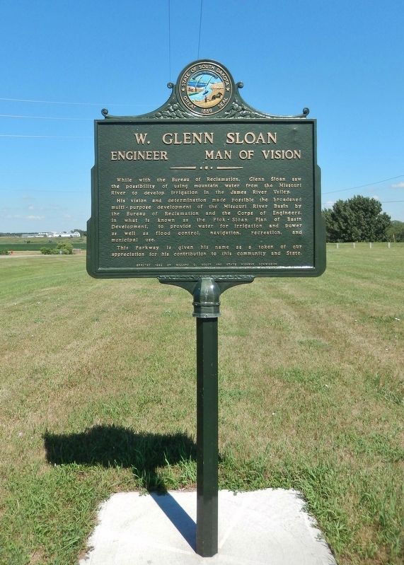
| 1 ► South Dakota, Beadle County, Huron — 349 — W. Glenn Sloan — Engineer Man of Vision — |
| On 4th Street NE (U.S. 14) at Jersey Avenue NE, on the right when traveling east on 4th Street NE. | |||
| 2 ► South Dakota, Bon Homme County, Springfield — Lewis and Clark / Springfield — Lewis and Clark National Historical Trail — |
| On Walnut Avenue at 5th Street on Walnut Avenue. | |||
| 3 ► South Dakota, Brookings County, Bruce — Legend of the Separation of the Lakes — The Legend of Tetonkaha — |
| On Oakwood Drive. | |||
| 4 ► South Dakota, Brookings County, Bruce — 8 — Oakwood Lakes State Park — Breastworks / Te-Tonka-Ha / Nicollet and Fremont — |
| Near South Oakwood Shoreline Drive. | |||
| 5 ► South Dakota, Brookings County, Bruce — Significant Site — |
| 6 ► South Dakota, Brookings County, Bruce, Oakwood Township — 1 — Cottonwood — Station 1 — Tetonkaha Trail — |
| Near Oakwood Drive, 1.7 miles north of 204th Street (County Highway 6). | |||
| 7 ► South Dakota, Brookings County, Bruce, Oakwood Township — 2 — Hackberry — Station 2 — Tetonkaha Trail — |
| Near Oakwood Drive, 1.7 miles north of 204th Street (County Highway 6). | |||
| 8 ► South Dakota, Brookings County, Bruce, Oakwood Township — 14 — Muskrat — Station 14 — Tetonkaha Trail — |
| Near Oakwood Drive, 1.7 miles north of 204th Street (County Highway 6). | |||
| 9 ► South Dakota, Brookings County, Bruce, Oakwood Township — What is this earthen wall? — |
| Near Oakwood Drive, 1.7 miles north of 204th Street (County Highway 6). | |||
| 10 ► South Dakota, Brookings County, Lake Norden, Laketon Township — Historic Area — |
| On South Lake Drive east of 456th Avenue (County Highway 2), on the right when traveling east. | |||
| 11 ► South Dakota, Brookings County, Volga — 122 — Oakwood Lakes Big Sioux River - Volga — |
| On 211th Street (U.S. 81) 1.1 miles west of Caspian Avenue, on the right when traveling west. | |||
| 12 ► South Dakota, Brookings County, White — 253 — Lake Hendricks Norwegian Colony of 1873 / Brookings County — |
| On 197th Street, 15 miles east of U.S. 29, on the right when traveling west. | |||
| 13 ► South Dakota, Brookings County, White — 330 — Lake Hendricks State Park / Brookings County — |
| On Unnamed Road, 0.7 miles north of 201st Street, on the right when traveling north. | |||
| 14 ► South Dakota, Brown County, Columbia — Waterfowl — |
| On Sand Lake Dr., 0.2 miles east of County Highway 16, on the right when traveling east. | |||
| 15 ► South Dakota, Brown County, Columbia — Columbia Marsh — |
| On 396th Ave., 0.8 miles 120th St., on the right when traveling north. | |||
| 16 ► South Dakota, Brown County, Columbia — Sand Lake National Wildlife Refuge — Welcome to — |
| On Sand Lake Dr., 0.2 miles County Highway 16. | |||
| 17 ► South Dakota, Brown County, Columbia — The View from the Top — |
| On Sand Lake Dr, 0.2 miles County Highway 16. | |||
| 18 ► South Dakota, Brule County, Chamberlain — 114 — Sojourn at Camp Pleasant — Lewis & Clark Expedition — |
| On Interstate 90 at milepost 264. | |||
| 19 ► South Dakota, Brule County, Chamberlain — State Capitol - Pierre — |
| On I-90 E, on the right when traveling east. | |||
| 20 ► South Dakota, Brule County, Chamberlain, Chamberlain Township — The Missouri River — Chamberlain and the Lewis & Clark Expedition — |
| Near State Highway 50 south of Thunder Road, on the right when traveling south. | |||
| 21 ► South Dakota, Buffalo County, Fort Thompson — The Crow Creek Reservation — |
| On State Highway 47 north of Lower Road, on the right when traveling south. | |||
| 22 ► South Dakota, Butte County, Belle Fourche — Belle Fourche — "Beautiful Fork" — |
| On State Street (Business U.S. 212) just east of 8th Avenue, on the left when traveling east. | |||
| 23 ► South Dakota, Campbell County, Pollock — 662 — Old Pollock / Lot Distribution in New Pollock / Lake Pocasse — |
| On State Highway 1804 at 294th Ave, on the right when traveling west on State Highway 1804. | |||
| 24 ► South Dakota, Charles Mix County, Pickstown — Fort Randall Dam - Lake Francis Case — |
| On U.S. 18, 0.7 miles west of Lewis Avenue, on the right when traveling west. | |||
| 25 ► South Dakota, Charles Mix County, Pickstown, White Swan Township — A Gathering Place for Eagles — |
| 26 ► South Dakota, Charles Mix County, Pickstown, White Swan Township — Fort Randall Area — |
| 27 ► South Dakota, Charles Mix County, Pickstown, White Swan Township — Missouri River — |
| 28 ► South Dakota, Clay County, Vermillion — Buhrstone — |
| On East Main Street, 1 mile south of State Route 50, on the right when traveling west. | |||
| 29 ► South Dakota, Clay County, Vermillion — Confluence of the Vermillion and Missouri Rivers — |
| Near South Dakota Street, 1.5 miles south of U.S. 50, on the right when traveling south. | |||
| 30 ► South Dakota, Clay County, Vermillion — Lewis and Clark / Vermillion — Lewis and Clark National Historical Trail — |
| Near South Dakota Street, 1.5 miles south of State Route 50, on the right when traveling south. | |||
| 31 ► South Dakota, Clay County, Vermillion — Lewis and Clark Were Here...and Here... — |
| On State Highway 19, 0.1 miles north of 312th Street, on the left when traveling north. | |||
| 32 ► South Dakota, Clay County, Vermillion — Old Vermillion — |
| On Canby Street, 1.3 miles south of State Route 50, on the left when traveling west. | |||
| 33 ► South Dakota, Clay County, Vermillion — 413 — Vermillion / Historic Highway — |
| On West Cherry Street, 0.5 miles south of State Route 50, on the left when traveling west. | |||
| 34 ► South Dakota, Clay County, Vermillion — Welcome to Cotton Park — Missouri National Recreational River Water Trail — |
| On South Dakota Street, 0.1 miles south of East Broadway Street, on the right when traveling south. | |||
| 35 ► South Dakota, Codington County, South Shore — 452 — Legend of Punished Woman's Lake — |
| On South Dakota Route 20, 1 mile east of 462nd Avenue, on the right when traveling east. | |||
| 36 ► South Dakota, Davison County, Mitchell — 615 — Old Mill Stone — |
| On South Gamble Street at East Hanson Avenue, on the right when traveling north on South Gamble Street. | |||
| 37 ► South Dakota, Day County, Andover — Amsden Dam — |
| Near 140th Street, 0.2 miles east of 442nd Ave.. | |||
| 38 ► South Dakota, Dewey County, Gettysburg — Nača Inyanska Unwayu Onihan Owakpamni Tanni Oasnikiye — Naca' Monument and Old Agency Park — CRST Flora Stewardship Project — |
| On U.S. 212, 1.2 miles north of Old U.S. Highway 212, on the right when traveling east. | |||
| 39 ► South Dakota, Dewey County, Gettysburg — Naca Monument — |
| On U.S. 212, 1.2 miles north of Old U.S. Highway 212, on the right when traveling east. | |||
| 40 ► South Dakota, Fall River County, Hot Springs — 663 — Hot Springs, SD — |
| On Fall River Road (U.S. 385) near Hidden Nook Trail, on the right when traveling north. | |||
| 41 ► South Dakota, Gregory County, Pickstown — Fort Randall Dam - Lake Francis Case — |
| Near U.S. 18 west of Toe Road West, on the right when traveling east. | |||
| 42 ► South Dakota, Gregory County, Pickstown — Guardian of the Frontier — Missouri National Recreational River — |
| Near U.S. 18 west of Toe Road West, on the right when traveling east. | |||
| 43 ► South Dakota, Gregory County, Pickstown — Supply & Demand — |
| Near Stone Church Drive east of Toe Road West, on the right when traveling east. | |||
| 44 ► South Dakota, Gregory County, Pickstown — The Great Missouri River — Missouri National Recreational River — |
| Near U.S. 18 west of Toe Road West, on the right when traveling east. | |||
| 45 ► South Dakota, Gregory County, Pickstown — Welcome to Randall Creek Recreation Area — Missouri National Recreational River Water Trail — |
| On Randall Creek Road. | |||
| 46 ► South Dakota, Hamlin County, Castlewood — Civilian Conservation Corps Camp — Camp DSE-224 Poinsett located on the east bank of Dry Lake — Companies: 2751- August 4, 1934 to October 20, 1934 — |
| On 192nd Street (State Highway 28) near North Lake Drive, on the right when traveling west. | |||
| 47 ► South Dakota, Hand County, Miller — 704 — Harlan J. Bushfield & Vera S. Cahalan Bushfield — |
| On East 5th Street east of North Broadway (U.S. 14), on the right when traveling west. | |||
| 48 ► South Dakota, Hughes County, Pierre — A Tense Three Days — |
| Near State Highway 1804, 1.6 miles north of Grey Goose Road, on the left when traveling north. | |||
| 49 ► South Dakota, Hughes County, Pierre — Exploring the Lewis & Clark Trail — |
| On an unnamed road, 0.1 miles south of East Sully Avenue, on the left when traveling south. | |||
| 50 ► South Dakota, Hughes County, Pierre — Exploring the Lewis & Clark Trail — |
| On South Poplar Avenue, on the right when traveling south. | |||
| 51 ► South Dakota, Hughes County, Pierre — Farm Island Causeway — |
| Near Farm Island Road, 1 mile south of South Dakota Highway 34, on the right when traveling south. | |||
| 52 ► South Dakota, Hughes County, Pierre — Lewis & Clark Trail — Griffin Park — |
| Near Parkwood Drive, 0.2 miles south of East Dakota Avenue, on the right when traveling south. | |||
| 53 ► South Dakota, Hughes County, Pierre — 82 — Medicine Knoll River — |
| On Medicine Creek Road at South Dakota Highway 34, on the left when traveling north on Medicine Creek Road. | |||
| 54 ► South Dakota, Hughes County, Pierre — Missouri River Valley Archaeology — |
| Near Farm Island Road. | |||
| 55 ► South Dakota, Hughes County, Pierre — Much Was Accomplished — |
| Near Farm Island Road, 1 mile south of South Dakota Highway 34, on the right when traveling south. | |||
| 56 ► South Dakota, Hughes County, Pierre — 280 — Steamboat Reach — |
| On West Dakota Avenue west of Poplar Street, on the right when traveling east. | |||
| 57 ► South Dakota, Hughes County, Pierre — Steamboats on the Missouri — |
| On South Poplar Avenue south of West Missouri Avenue, on the right when traveling south. | |||
| 58 ► South Dakota, Hughes County, Pierre — Welcome to Steamboat Park! — |
| On South Poplar Street, 0.2 miles south of West Missouri Avenue, on the left when traveling south. | |||
| 59 ► South Dakota, Hughes County, Pierre, Raber Township — 40 — First Permanent Fur Post — |
| On State Highway 34 at milepost 233 at Chapelle Road, on the left on State Highway 34. | |||
| 60 ► South Dakota, Jerauld County, Wessington Springs — Historic Nobles Trail — |
| On State Highway 34, on the left when traveling north. | |||
| 61 ► South Dakota, Kingsbury County, De Smet — Site of Lake Henry Congregational Church — 1885 — 1932 — |
| On 437th Avenue at 209th Street, on the left when traveling south on 437th Avenue. | |||
| 62 ► South Dakota, Lake County, Madison — 113 — Lake Herman - Historic Points — 1 to 2 Miles South |
| On Territorial Road just south of U.S. 81, on the right when traveling south. Reported missing. | |||
| 63 ► South Dakota, Lawrence County, Deadwood — Elizabethtown — A Trail to Deadwood's Past — |
| On Main Street at Violin Street, on the right when traveling south on Main Street. | |||
| 64 ► South Dakota, Lawrence County, Deadwood — The Resilient Whitewood Creek — A Trail to Deadwood's Past — |
| Near Sherman Street (U.S. 85). | |||
| 65 ► South Dakota, Lawrence County, Pluma — Flooding & The Railroads — |
| On CanAm Highway (U.S. 85) north of U.S. 385, on the left when traveling north. | |||
| 66 ► South Dakota, Lawrence County, Spearfish — Spearfish Canyon Through Time — Bridal Veil Falls — |
| On U.S. 14A, 6 miles south of Business 90, on the left when traveling south. | |||
| 67 ► South Dakota, Lincoln County, Sioux Falls — Looking Into the Past — |
| Near 480th Avenue (County Highway 135) 0.2 miles south of 269th Street (County Highway 102), on the right when traveling north. | |||
| 68 ► South Dakota, Lincoln County, Sioux Falls, Springdale Township — A Landscape Shaped by Glaciers — |
| Near 480th Avenue (County Highway 135) 0.2 miles south of 269th Street (County Highway 102). | |||
| 69 ► South Dakota, Lyman County, Oacoma — 242 — This was until 1953 American Island — |
| On Business Interstate 90, 2 miles east of 339th Avenue, on the right when traveling east. | |||
| 70 ► South Dakota, Lyman County, Reliance — 188 — Historic Highway — |
| On State Highway 47, 4 miles south of 248th Street (County Road 6), on the left when traveling south. | |||
| 71 ► South Dakota, Lyman County, Vivian — 602 — Medicine Creek Rest Area — |
| Near Interstate 90 at milepost 218. | |||
| 72 ► South Dakota, McCook County, Canistota, Greenland Township — Dam and Spillway — Lake Vermillion Recreation Area — |
| Near Adventure Drive east of North Drive, on the left when traveling east. | |||
| 73 ► South Dakota, McCook County, Canistota, Greenland Township — Otter Stream — Lake Vermillion Recreation Area — |
| Near Adventure Drive east of North Drive, on the right when traveling east. | |||
| 74 ► South Dakota, Minnehaha County, Baltic — 626 — Saint Olaf Roller Mill and Power Dam — |
| Near Elm Avenue at 2nd Street. | |||
| 75 ► South Dakota, Minnehaha County, Brandon — 665 — Eminija, Minnesota Territory — |
| On South Splitrock Boulevard (State Highway 11) 0.4 miles south of South Sioux Boulevard, on the right when traveling south. | |||
| 76 ► South Dakota, Minnehaha County, Brandon — Fur Trapper Ambush — |
| Near South McHardy Road, 0.1 miles south of East Aspen Boulevard, on the right when traveling south. | |||
| 77 ► South Dakota, Minnehaha County, Brandon — Split Rock Creek Tragedy — |
| Near South McHardy Road, 0.1 miles south of East Aspen Boulevard, on the right when traveling south. | |||
| 78 ► South Dakota, Minnehaha County, Dell Rapids — Dell Rapids — |
| On East 3rd Street at Washington Avenue, on the right when traveling east on East 3rd Street. | |||
| 79 ► South Dakota, Minnehaha County, Sioux Falls — "RISE" and the Big Sioux River — |
| Near South Cliff Avenue, 0.2 miles south of East 41st Street, on the right when traveling south. | |||
| 80 ► South Dakota, Minnehaha County, Sioux Falls — 1897 Bridge at Iverson Crossing — |
| On Iverson Crossing Road, 0.4 miles west of 481st Avenue (State Highway 11), on the left when traveling west. | |||
| 81 ► South Dakota, Minnehaha County, Sioux Falls — 40mm Twin Mount AA Gun — |
| Near West 12th Street at South Kiwanis Avenue. | |||
| 82 ► South Dakota, Minnehaha County, Sioux Falls — Banning's Mill and Crossing — |
| On 41st Street west of Riverview Avenue, on the right when traveling east. | |||
| 83 ► South Dakota, Minnehaha County, Sioux Falls — Battleship X — U.S.S. South Dakota — |
| On West 12th Street (State Highway 42) just west of South Kiwanis Avenue, on the right when traveling east. | |||
| 84 ► South Dakota, Minnehaha County, Sioux Falls — Beginning of Great Changes — |
| Near North Weber Avenue, 0.2 miles south of East Falls Park Drive, on the right when traveling south. | |||
| 85 ► South Dakota, Minnehaha County, Sioux Falls — Bronze Propeller — |
| Near West 12th Street at South Kiwanis Avenue. | |||
| 86 ► South Dakota, Minnehaha County, Sioux Falls — Inland Seas — |
| Near North Weber Avenue, 0.2 miles south of East Falls Park Drive. | |||
| 87 ► South Dakota, Minnehaha County, Sioux Falls — Philander Prescott — |
| Near North Weber Avenue, 0.2 miles south of East Falls Park Drive. | |||
| 88 ► South Dakota, Minnehaha County, Sioux Falls — Port Hatch — |
| Near West 12th Street at South Kiwanis Avenue. | |||
| 89 ► South Dakota, Minnehaha County, Sioux Falls — Sioux Falls — 1950-2019 — |
| Near East 26th Street, 0.2 miles west of South Southeastern Avenue, on the right when traveling west. | |||
| 90 ► South Dakota, Minnehaha County, Sioux Falls — The Great Bend — |
| On West 57th Street north of Old Yankton Circle, on the right when traveling west. | |||
| 91 ► South Dakota, Minnehaha County, Sioux Falls — The Gun Barrel Story — |
| On West 12th Street at South Kiwanis on West 12th Street. | |||
| 92 ► South Dakota, Minnehaha County, Sioux Falls — The Promise of Electricity — |
| On North Weber Avenue. | |||
| 93 ► South Dakota, Minnehaha County, Sioux Falls — USS South Dakota Battleship Outline — |
| Near West 12th Street at South Kiwanis Avenue. | |||
| 94 ► South Dakota, Minnehaha County, Sioux Falls — Yankton Trail Bridge — |
| On West 57th Street north of Old Yankton Circle, on the right when traveling west. | |||
| 95 ► South Dakota, Minnehaha County, Sioux Falls, Downtown — 8th Street Bridge — |
| On East 8th Street east of North Phillips Avenue, on the right when traveling west. | |||
| 96 ► South Dakota, Minnehaha County, Sioux Falls, Downtown — 8th Street Bridge — |
| Near East 7th Street east of North Phillips Avenue, on the right when traveling east. | |||
| 97 ► South Dakota, Minnehaha County, Sioux Falls, Downtown — Cascade Mill — |
| Near East 8th Street, 0.1 miles east of North Phillips Avenue, on the right when traveling east. | |||
| 98 ► South Dakota, Minnehaha County, Sioux Falls, Downtown — Cascade Milling Company — |
| Near East 7th Street east of North Phillips Avenue, on the right when traveling east. | |||
| 99 ► South Dakota, Minnehaha County, Sioux Falls, Downtown — Course — 8th Street Bridge — |
| Near East 8th Street east of North Phillips Avenue, on the right when traveling east. | |||
| 100 ► South Dakota, Minnehaha County, Sioux Falls, Downtown — Flooding — |
| Near North Cherapa Place south of East 6th Street. | |||
145 entries matched your criteria. The first 100 are listed above. The final 45 ⊳