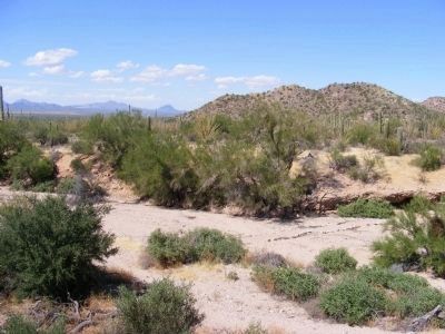
Below is the dry bed of an intermittent stream called a desert wash. For a short time, during desert thunderstorms, flash floods rush down the mountain slopes and through desert washes to nearby rivers. However, beneath the wash’s sandy surface, . . . — — Map (db m83148) HM
Lifeline
Beaver Creek has always been a major focus of life in the Verde Valley. Prehistoric Sinagua farmers constructed Montezuma Castle and other structures near the creek. They dug ditches to carry creek water to irrigate the fields of . . . — — Map (db m40868) HM
On South Cortez Street just north of West Goodwin Street, on the left when traveling north.
The Water Table By March of 1881, fire wells like this one were hand-dug on the four corners of the Courthouse Plaza. At the time, the water table was high enough to allow bucketing of water for fire emergencies. These wells were abandoned . . . — — Map (db m157663) HM
Soldiers from Camp Verde were early tourists to Sedona, enjoying the beauty, cooler temperatures and Oak Creek as a break from the camp.
As early as 1895, Lou Thomas turned Bear Howard’s cabin into a two-story hunting fishing lodge. It was there . . . — — Map (db m133684) HM
Near Prison Hill Road, 0.5 miles north of Harold C. Giss Parkway.
A Positive Impact Starting in 1905, dams were constructed along the Colorado River that brought positive change to the Southwest. Dams and canals brought a safe and secure source of water and power and enhanced the ability of people to live in . . . — — Map (db m158380) HM
Near Prison Hill Road, 0.5 miles north of Harold C. Giss Parkway.
Restoration in Progress The Yuma East Wetlands (YEW) is an innovative restoration project pioneered by the Quechan Indian Tribe and the City of Yuma. The 1,418 acres of the YEW are comprised of native riparian wetland, and aquatic habitats . . . — — Map (db m158390) HM
On Main Street (State Highway 23) south of Spring Street, on the right when traveling south.
The Eureka Springs area's reputation as a health resort has its origins in the Civil War. Late 19th-century accounts claim Dr. Alvah Jackson treated sick and wounded soldiers during the war. In early 1865, Maj. J. W. Cooper, who led Confederate . . . — — Map (db m59967) HM
On Main Street (State Highway 23) at Armstrong, on the left when traveling north on Main Street.
This three-story limestone building with metal-clad roof enclosing the top story was constructed in 1889 by Samuel L. Calif. For fifty years it served as a residence, general merchandise store, and boarding house. About 1948 the building was . . . — — Map (db m90699) HM
On Spring Street north of Main Street (Arkansas Highway 23), on the left when traveling north.
I stood here growing so many years,
I shared your laughter, I shared your tears.
My life was good, beginning to end,
and this is a wish I'd like to send.
Be happy and kind to all around,
and let not sorrow be ever found.
The spirit of . . . — — Map (db m59971) HM
On Main Street (State Highway 23) north of Benton Street, on the left when traveling south.
These two large limestone public buildings anchor this part of downtown Eureka Springs. They span the deep ravine cut by Leatherwood Creek which flows in a tunnel beneath all the buildings on this entire part of Main Street.
[Photo 1.]
This . . . — — Map (db m59964) HM
On Main Street (State Highway 23) 0.1 miles north of Magnetic Drive, on the left when traveling north.
First by horseback, wagons or on foot, invalids from all over this region flocked to Eureka Springs in 1879 to seek cures from the miraculous healing springs. But soon there were easier ways to arrive - stagecoaches, then trains. This laid a base . . . — — Map (db m80211) HM
Through time, Cedar Falls has cut through vast layers of
sandstone, creating Cedar Creek Canyon which reaches a
depth of 400 feet.
The rock layer capping Petit Jean Mountain is sandstone, an
ancient sedimentary formation deposited as sand in a . . . — — Map (db m233681) HM
On Petit Jean Mountain Road, on the right when traveling west.
Formed over eons, this inspiring landscape offers us a sense of wonder.
The landscape of Petit Jean State Park reveals a
story of stone, weather, and time.
Much of Petit Jean's exceptional landscape results from
earthen rock . . . — — Map (db m233687) HM
Exploring the geologic story here connects you with Petit Jean Mountain
Lepidodendron
One of the dominant tree-like plants of
either the Carboniferous Period (359-299
million years ago) or the late
Pennsylvanian Period (323-299 . . . — — Map (db m233678) HM
On Grand Promenade Trail, 0.2 miles south of Fountain Street, on the right when traveling south.
The Peak Trail is a short, moderately steep route up Hot Springs Mountain.
The summit has been a traditional site for observation towers. Unlike the 216-foot-high steel structure of today, the earliest wooden tower of the 1870s barely . . . — — Map (db m145684) HM
Near State Highway 362, 1.8 miles east of U.S. 49.
Before Lewis and Clark explored the Louisiana Territory in 1804, little was known about the land or the animals of this vast region. President Jefferson, interested in America's natural resources, instructed the expedition to collect specimens and . . . — — Map (db m155194) HM
Near State Highway 362, 1.8 miles east of U.S. 49.
This park preserves and protects two of Arkansas's greatest heritages: The "initial point" of the 1815 Louisiana Territory land survey and one of the state's few "headwater" swamps. The elevated boardwalk allows for safe viewing of the park's . . . — — Map (db m155180) HM
Near State Highway 362, 1.8 miles east of U.S. 49.
Louisiana Purchase Historic State Park is situated in an unusual habitat — a "headwater" swamp. This swamp differs greatly from the more common "backwater" swamps. Found within the floodplain zones of large streams and rivers, backwater swamps . . . — — Map (db m155188) HM
Flooding, a long-feared natural phenomenon, is a very real concern throughout the region. Water has spilled from the banks of the Mississippi many times over the years, causing widespread fear and devastation. The Great Mississippi Flood of 1927, . . . — — Map (db m231575) HM
Seasons change. As they do, birds and other wild animals migrate from one place to the next to find food. Many birds follow the twists and turns of the Mississippi River as they journey from the northern United States to their winter breeding . . . — — Map (db m229321) HM
Built in 1961, the Helena bridge is about a mile long and 28 feet wide. It stretches across the Mississippi River, linking Helena with the town of Lula, Mississippi via US 49.
Before the bridge
Until the early 1960s, there was no bridge . . . — — Map (db m231574) HM
Among our nations’s most valuable treasures: a web of inland waterways that winds its way through America’s heartland to the Mississippi River. Boats carrying people and freight use these well-traveled “marine highways” to travel from one city or . . . — — Map (db m229324) HM
Found in the floodplains of rivers and streams, these wetland communities depend on water. Unlike a swamp (where water is always present), bottomland hardwood forests experience seasonal flooding.
Disappearing forest
Before the arrival . . . — — Map (db m231810) HM
The impact of stormwater runoff on the Mississippi River is an environmental concern.
The quality and quantity of water in all of our streams, rivers, lakes, aquifers, and oceans is diminishing. We can reverse this negative trend by becoming . . . — — Map (db m231766) HM
On Center Street at East Avenue, on the left when traveling west on Center Street.
The earliest known inhabitants of the hardwood forest of the Ozarks migrated to Arkansas over 12 thousand years ago through the Great Bering Strait. For the next two thousand years Bluff Dwellers hunted the mountain plateaus before the Quapaws, . . . — — Map (db m59882) HM
Historically Alameda was a peninsula, rich in
natural resources. Native peoples gathered food
and materials from bay salt marshes, abundant
oak forests, and nearby shorelines. From the
early 1800's the western tip of the peninsula
now known as . . . — — Map (db m157046) HM
On Shoreline Drive north of Broadway, on the right when traveling south.
Before you is on e of the few remnant salt marshes in the San Francisco Bay. As important and delicate ecosystems, salt marshes serve as nurseries for crab and fish species, provide critical habitat for endangered plants and birds, and protect . . . — — Map (db m218655) HM
For decades the dumping of construction debris of a growing industrial society filled in the marshes and tide flats of the Albany Waterfront.
An unsightly peninsula began to form...hidden from the main stream of urban life.
In 1984 the dumping . . . — — Map (db m197620) HM
On Buchanan Street, on the right when traveling west.
The explosive powder industry developed around San Francisco during the Civil War to
supply California's gold mines. A powder plant opened at Albany's remote Fleming Point in
1879. Others on the north side of Albany Hill followed. Nobel Depot, . . . — — Map (db m174552) HM
On Buchanan Street, on the right when traveling west.
Before the Ice Age waned about 10,000 years ago, this area was part of a wide valley
through which the Sacramento River flowed on its way to the Pacific Ocean near the
Farallon Islands. The river spilled over a waterfall at the Golden Gate . . . — — Map (db m174544) HM
Outcroppings of weathered rock are a prominent feature of the Berkeley Hills, providing evidence of this area’s complex geological past. Composed of Northbrae rhyolite, Indian Rock is an ancient volcanic remnant. Native Ohlone communities gathered . . . — — Map (db m53852) HM
On Le Roy Avenue at Hawthorne Terrace on Le Roy Avenue.
City of Berkeley Landmarks
designated in 1995
When the La Loma Park subdivision was created in 1900, the streets were laid out in harmony with the natural contours of the land as advocated by Berkeley’s Hillside Club. The rustic quality of the . . . — — Map (db m53884) HM
On San Fernando Avenue at Yosemite Road on San Fernando Avenue.
Berkeley History
In the early 1900s, the natural beauty of this undeveloped district, with dramatic rock outcroppings and ancient oaks made it a favorite destination for picnickers and hikers.
After a campaign to make the area a city park . . . — — Map (db m53848) HM
On Claremont Avenue at The Uplands on Claremont Avenue.
City of Berkeley Landmark
designated in 1984
Claremont, a 1905 subdivision, was originally part of the 125-acre Edson Adams ranch. Early advertisements for the tract enticed families to leave the noisy, crowded city behind and head for . . . — — Map (db m54679) HM
Near Cedar Street east of Spruce Street, on the right when traveling west.
City of Berkeley Landmark
designated in 2004
The Hillside Club was founded in 1898 by Berkeley women intent on preserving the natural beauty of the hills. It soon became an influential cultural force. North Berkeley’s curved streets with old . . . — — Map (db m54186) HM
Near Shattuck Avenue near Berryman Street. Reported permanently removed.
Live Oak Park was created in 1914 when the City of Berkeley purchased four acres from landowners R.S. Penniman and Michael O’Toole. Mr. Penniman’s brown shingle house served as the park clubhouse and also, from 1916-1936, as Berkeley’s North Branch . . . — — Map (db m194669) HM
Here a venerable oak tree was saved by Annie Maybeck (1867-1956), wife of architect Bernard Maybeck. She is said to have "marched off to city hall" to protest the cutting of native trees during street paving early in the 20th Century. She and other . . . — — Map (db m18562) HM
On La Loma Avenue at Virginia Street on La Loma Avenue.
City of Berkeley Landmarks
designated in 1983
In the late 1890s a group of concerned women formed the Hillside Club to “encourage artistic homes built of materials complementing the natural beauty of the Berkeley Hills.” The Club soon . . . — — Map (db m53886) HM
On La Loma Avenue at Hilgard Avenue on La Loma Avenue.
City of Berkeley Landmarks
designated in 1996
This is one of the earliest houses built in the north Berkeley hills. George Jensen came from Denmark and was a contractor in Los Angeles before moving to Berkeley. Members of the Jensen family lived . . . — — Map (db m53887) HM
On Eden Landing Road near Arden Road, on the left when traveling south.
The former Salt Evaporation Ponds in front of you have been divided into sections with different levels of saltiness. By studying water conditions, bird use, and prey abundance here, researchers will learn how to create the most opportunities for . . . — — Map (db m206505) HM
On Whitesell Street at Bay Center Place, on the right when traveling south on Whitesell Street.
As part of the City of Hayward’s commitment to sustainability, we promote healthy, environmentally-sound landscape practices.
Since 2009, the City required that large civic landscape projects be verified as Bay-Friendly Rated Landscapes. This . . . — — Map (db m208210) HM
Marker Once:
Once plentiful on California beaches, western snowy plovers now face extinction due to habitat loss from coastal development and beach recreation. Fortunately, dry salt ponds offer these sparrow-sized shorebirds an . . . — — Map (db m207071) HM
Dramatic reductions in tidal wetlands over the past 200 years, due to urban development, agriculture, and salt production, resulted in significant declines in marsh-dependent wildlife. In addition to providing critically important habitat for fish, . . . — — Map (db m207017) HM
Marker One:
Balancing the needs of people and wildlife has long challenged Californians. Gold Rush-era settlers believed the best value of Baylands came from converting them to salt ponds, housing, or other human uses. Today we recognize . . . — — Map (db m207078) HM
Near Laughlin Ranch Loop south of Laughlin Road, on the right when traveling south.
Brushy Peak is a 1,702-foot landmark at the juncture of the San Francisco Bay Area, the California Delta, and the Central Valley. The peak and its environs have been recognized as sacred by generations of native Californians. Due to its . . . — — Map (db m198223) HM
Near Skyline Boulevard, 0.5 miles north of Joaquin Miller Road.
Until at least 1851, Redwood trees on this site were used as landmarks to avoid striking the treacherous submerged Blossom Rock in San Francisco Bay west of Yerba Buena Island. Although by 1855 the original stems had been logged, today's trees are . . . — — Map (db m100564) HM
On Jefferson Street at 7th Street, on the right when traveling south on Jefferson Street.
1853
Oakland was shaped
by seven GREEN SQUARES
Downtown’s living rooms
now only five
Parks bring out the
Goodness of good people — — Map (db m72832) HM
Lake Merrit, once a tidal marsh system and estuary
with an inlet to the Bay, was home to a variety of
wildlife including leopard sharks and bat rays.
Sightings of these creatures likely inspired the
stories of sea monsters in the Lake. Such . . . — — Map (db m163099) HM
Near Sanborn Drive near Joaquin Miller Road, on the left when traveling north.
Joaquin Miller Park was formed in 1917 when the City of Oakland and its citizens – led by The California Writers Club – purchased 68 acres from the estate of Joaquin Miller, the noted 19th century “Poet of the Sierras” and . . . — — Map (db m71737) HM
Near Montclair Railroad Trail south of Paso Robles Drive.
The Shepherd Canyon Corridor Plan was created by the City of Oakland in 1975 to
provide a vision for the development of the Canyon after CALTRANS dropped plans
for Highway 77 along the former Sacramento Northern Railroad Right of Way. The
Oakland . . . — — Map (db m185619) HM
Over time, different groups of people changed the landscape to meet their needs. The once wide open valley and its large lagoon have been transformed into smaller parcels with new uses for a growing population. Today’s seven acre park is a vestige . . . — — Map (db m217071) HM
On Main Street at Abbie Street, on the right when traveling north on Main Street.
Here stands one the first commercial buildings in Pleasanton, possibly as old as 1864. Originally a general store, this building has been a bar, brothel, bank and unofficial Wells Fargo stagecoach stop. Since 1959 it has become well-known as the . . . — — Map (db m211819) HM
How do you climb the wall of a dam using fins? The dam blocked the natural migratory route of the steelhead trout, prohibiting them from swimming up San Leandro Creek to spawn in their natural habitat, what is now upper San Leandro Reservoir and . . . — — Map (db m71713) HM
Through his life’s dreams and efforts. Thousands enjoy skiing, good water, scenic meadows and preservation of Bear Valley’s natural beauty.
In Appreciation — — Map (db m10965) HM
Near South Main Street/Golden Chain Highway (State Highway 49), on the right when traveling north.
Hydraulic Mining was the largest and most destructive form of mining. Water, brought through flumes and ditches from high up in the mountains, was redirected into an ever-narrowing channel and out through a giant iron nozzle, called a . . . — — Map (db m56649) HM
The large outcrop with the staircase and cables is Sentinel Rock. The Civilian Conservation Corps (CCC) installed the steps and railings on Sentinel Rock sometime berween 1933 and 1942. It is now a popular climbing rock.
One of the responses of . . . — — Map (db m199523) HM
This magnificent Valley Oak, Quercus lobato, is estimated to date as far back as the 1600s. This tree is a Designated Heritage Resource that continues to thrive alongside the San Ramon Creek and still drops acorns as it did long ago. The Bay . . . — — Map (db m200173) HM
Near San Francisco Bay Trail / Cerrito Creek Trail.
Cerrito Creek and its branches carry
rain and spring water from the East Bay Hills
to San Francisco Bay. Native Americans lived along
its banks. It became the boundary between vast
Spanish land grants and, later, the county line.
The City . . . — — Map (db m155139) HM
In 1988, a massive oil spill from the nearby Shell Refinery
inundated the Carquinez Strait and downstream marshes
including McNabney Marsh. As a result of a settlement with
a number of agencies, Shell Oil paid over $12 million into a
Natural . . . — — Map (db m145095) HM
In 1919, Colonel Robert Bradford Marshall
of the United States Geological Survey
proposed an unprecedented project
of dams, canals, and pumps to
move Delta-bound water from
California's wet north and snowy
Sierra Nevada mountains to its
arid . . . — — Map (db m190979) HM
Corcoran Lake filled the Central Valley
760,000 years ago (including where you
now stand)! It drained to the ocean at
today's Monterey Bay. Tectonic forces
plugged the outlet and tilted the
lakebed to the north 200,000 years
later. The surging . . . — — Map (db m190604) HM
Far from being an ancient geological feature, our Delta is a virtual newcomer.
Imagine sunrise here 14,000 years ago.
Dawn illuminates the glacier-coated Sierra
Nevada Mountains. The San Joaquin and
Sacramento Rivers merge nearby, . . . — — Map (db m190991) HM
Picture a river running through a desert.
Now picture a desert running through a river.
The San Joaquin River once flowed
uninterrupted from high mountains,
through the arid valley bearing its name,
to the Delta. Floods enriched . . . — — Map (db m190726) HM
On Wildcat Canyon Road, on the right when traveling west.
The vegetation around you is quite different from that observed
during the Anza Expedition of 1776. The pine forests across the
reservoir and on San Pablo Ridge were not here. Oak-bay
woodlands filled the ravines as they do now, but the open . . . — — Map (db m153306) HM
Near Orinda Way south of Irwin Way, on the right when traveling north.
San Pablo Creek, Orinda’s biggest creek, flow from the Glorietta neighborhood, through both side of downtown Orinda, all the way to Wagner Ranch Nature Area, and into the San Pablo Reservoir. The City of Orinda has many other creeks, as you . . . — — Map (db m222683) HM
In 1775 and 1776, Lt. Colonel Juan Bautista de Anza, Father
Pedro Font, along with 240 settlers, soldiers, and others traveled
1,800 miles from Sonora, Mexico to Monterey, California. Anza
and Font, with a small group passed through by horseback . . . — — Map (db m145988) HM
This Unit of 500 Acres in the
National Tribute Grove
is preserved through the
National Society
Daughters of the American Revolution
to honor those who served in the armed forces
of the United States in World War II
and to . . . — — Map (db m241927) WM
On Howland Hill Road, on the left when traveling east.
This grove is given to the State of California for the preservation of these ancient trees by Mr. and Mrs. Jesse H. Metcalf of Rhode Island. — — Map (db m1510) HM
Near Coloma Road (California Route 49) north of Mt Murphy Road.
As miners moved from Sierra streams to gulches and hills, they found rich gold deposits in ancient river beds, some far from water. By 1853 they had begun working these gravels with water delivered through hoses and nozzles. Ultimately, this major . . . — — Map (db m215029) HM
This giant Jeffrey pine, the Old Veteran, is 350 to 400 years old. Although this tree still stands, most of the pines of the same age fell to loggers in the late 1800s. This tree is the only one of its kind near the visitor center.
Notice that . . . — — Map (db m212297) HM
On State Highway 180 at Forest Service Road 13S03, on the left when traveling north on State Highway 180.
One of the largest stands of Giant Sequoias, it contained some of the finest Big Trees. The grove was logged as a private land between 1897 and 1907, first by the Sanger Lumber Company and later by Hume-Bennett Lumber Company, which in 1909 . . . — — Map (db m52239) HM
On Newton B. Drury Scenic Parkway, on the left when traveling north.
Conservationist, author, anthropologist, a founder of the Save-the-Redwoods League.
This area of 1600 acres, habitat of the last surviving herd in California of Roosevelt Elk is established as a memorial by
· De Forest Grant
· John D. . . . — — Map (db m32569) HM
Near Newton B. Drury Scenic Parkway, on the right when traveling north.
Your journey along the Newton B. Drury Scenic Parkway follows the historic Redwood Highway. When the highway reached this area in the early 1920s, a new era of automobile-based tourism was booming. Then, just as today, iconic Big Tree was an . . . — — Map (db m176816) HM
On Avenue of the Giants (California Route 254) at Lum Street, on the right when traveling north on Avenue of the Giants.
A World class Forest Preserve
Containing over 53,000-acres, Humboldt Redwoods State Park includes some of the world's most impressive redwood forests, many miles of river frontage, and nearly 100 miles of hiking, riding and mountain bike . . . — — Map (db m176731) HM
Near Avenue of the Giants (State Highway 254) 0.2 miles south of Dyerville Loop Road, on the left when traveling south.
Laura Perrott Mahan 1867-1937 James P. Mahan 1867-1937 • Pioneers in the Save-the-Redwoods League • The California State Park Commission has dedicated to their memory this site where on Nov.19.1924, Mr. and Mrs. Mahan discovered that logging had . . . — — Map (db m150292) HM
Indigenous People
Since time immemorial, Lalongkok peoples have lived respectfully among and cared for these redwoods. As Europeans arrived, their cultural ideology led to lasting negative impacts to native cultural practices and to . . . — — Map (db m190829) HM
Near Airport Road just west of California Route 190.
He laid the foundation of the National Park Service, defining and establishing the policies under which its areas shall be developed and conserved unimpaired for future generations. There will never come an end to the good that he has done. — — Map (db m158620) HM
On California Route 136, 1 mile north of Keeler, on the left when traveling north.
Owens Lake was once over 300 feet deep and part of a large ancient freshwater lake. As the climate changed over centuries, the lake began to dry up leaving behind concentrated minerals and salts. By 1905, diversion of water by farmers in the Owens . . . — — Map (db m72575) HM
Near U.S. 395 at Los Angles Aqueduct Road, on the left when traveling north.
The Alabama Gates and gate house were constructed in 1913 when the Los Angeles Aqueduct was built to dewater the aqueduct when maintenance is necessary. On November 16, 1924, seventy or more local citizens seized the aqueduct at the Alabama Gates . . . — — Map (db m93252) HM
Near Chester Avenue just north of 36th Street, on the left when traveling north.
When European explorers first came to what is now Kern County, it was inhabited predominantly by indigenous peoples known as the Chumash, Kawaiisu, Kitanemuk, Serrano, Tubatulabal and Yokuts.
The Kern County area was first claimed by the . . . — — Map (db m167101) HM
Near Station Road, 0.2 miles west of Morris Road, on the left when traveling west.
Back From the Brink of Extinction
Half a million tule elk once roamed
the marshes and grasslands of
California. The Gold Rush began an
era of commercial hunting and
agricultural practices that decimated
the elk and their . . . — — Map (db m184928) HM
On Green Street at E Street, on the right when traveling north on Green Street.
In 1947 the Tehachapi Soil Conservation District was organized to advise the farm industry. It was apparent by the early 1960s that if agriculture were to continue as economic force in the District, additional water had to be found. In the early . . . — — Map (db m135047) HM
On Cameron Canyon Road, on the right when traveling east.
First Panel:
Wind Development
Why Tehachapi Pass?
1) Close to Energy Users
The proximity of Tehachapi Pass to the Los Angeles Basin makes it an attractive location for wind power development, as it reduces the length, . . . — — Map (db m63166)
On Green Street, on the right when traveling north.
During the first US energy crises in the 1970s the need for a sustainable and renewable energy was evident and President Jimmy Carter created the first renewable energy program in the country. In the early 1980s the first commercial electricity from . . . — — Map (db m135045) HM
On State Highway 20 at Reclamation Road, on the left when traveling west on State Highway 20.
Freshwater Marsh
A freshwater marsh once surrounded Bloody Island prior to land reclamation
efforts that began in the late 19th century. Native plants within marshes around
Clear Lake included tules (Scirpus acutus), rushes (Juncus sp.), . . . — — Map (db m143781) HM
Near Metropole Avenue, 0.1 miles south of Crescent Avenue, on the right when traveling south.
In all the world there was no trip like a
nocturnal ride aboard Blanche W,
skimming through a spray of flying fish
darting from the waters of Catalina Island.
William Wrigley Jr. commissioned the
sightseeing boat in 1924 and named . . . — — Map (db m208327) HM
On Sunland Boulevard at Fenwick Street, on the left when traveling east on Sunland Boulevard.
The Verdugo Hills and Tujunga Wash
hold a surprising wealth of biodiversity.
When you look out at these areas, what do you see?
You might be looking at plants that grow in
the San Gabriel Mountains but not in the Santa Monica
Mountains — and . . . — — Map (db m198564) HM
Near Glenoaks Boulevard north of Foothill Boulevard, on the left when traveling north.
Marge Feinberg’s 1974 Master’s Thesis envisioning a wilderness trail encircling the San Fernando, La Crescenta and Simi Valleys and adjacent mountain ranges led to a California law establishing the Rim of the Valley Trail Corridor in the Santa . . . — — Map (db m139166) HM
On East Jib Street at Jib Street, on the left when traveling south on East Jib Street.
Today, Ballona Lagoon is a 16-acre remnant of a formerly extensive coastal wetland. Like other southern California wetlands, urbanization has reduced its size and degraded its habitat over the last century. Historically, Ballona was much larger . . . — — Map (db m128456) HM
Wood for the first pier to be erected off Windward Avenue arrived August of 1904 and
construction began in earnest. A 1,600 foot t-shaped pier rose out of the quiet swells of the Pacific Ocean in anticipation of Venice-of-America's grand . . . — — Map (db m226024) HM
Malibu Lagoon is where Malibu Creek meets the Pacific Ocean. The result is a unique environment of plant and animal life adapted to fresh and salt water. Over two hundred species of birds can be seen here at various times of the year. Down these . . . — — Map (db m237677) HM
The hills where you stand are a part of one of the world's geological wonders, The San Andreas Rift -- A great fault and earthquake zone.
__________
Because of the movements along this fault zone, the pink and tan colored Punchbowl rocks seen . . . — — Map (db m115197)
On Palos Verdes Drive South, 0.2 miles east of Sea Cove Drive, on the right when traveling east.
Located approximately 20 miles from the mainland, Santa Catalina Island rises 2000 feet above sea level, approximately 500 feet higher than the Palos Verdes Peninsula. The island is over 20 miles long, making it the longest of the eight California . . . — — Map (db m157646) HM
The famous La Monica Ballroom, built by internationally renowned ballroom designer T.H. Eslick on this site in 1924, was once the largest ballroom in the world. Vast and ornate, the ballroom consumed so much of the Pier that, when viewed from the . . . — — Map (db m206075) HM
On Ocean Drive south of California Avenue / California Incline, on the right when traveling south.
To honor George T. Hastings, author of “Trees of Santa Monica,” October 10, 1963—his 88th birthday—in appreciation of his dedication in sharing his knowledge and love of trees, flowers and birds.
To honor Grace L. . . . — — Map (db m130429) HM
Point Reyes Light has guided and cautioned mariners along this hazardous coast for over 100 years. Built by the U.S. Lighthouse Service in 1870, it came under management of the U.S. Coast Guard in 1939. Resident personnel operated the station until . . . — — Map (db m63502) HM
The wife of a lighthouse keeper once planted a small garden nearby, but with no success. As soon as the carrots sprouted the wind blew them away. Few plants can face up to the ocean’s harsh influences.
On these fogbound, windblown rocks, . . . — — Map (db m63363) HM
The intriguing rock exposure in front of you is part of a formation that caps the highest hills in this area. The Point Reyes Conglomerate is a formation consisting of a sandy matrix embedded with pebbles, cobblestones, and boulders. Geologists . . . — — Map (db m63377) HM
3884 entries matched your criteria. Entries 101 through 200 are listed above. ⊲ Previous 100 — Next 100 ⊳