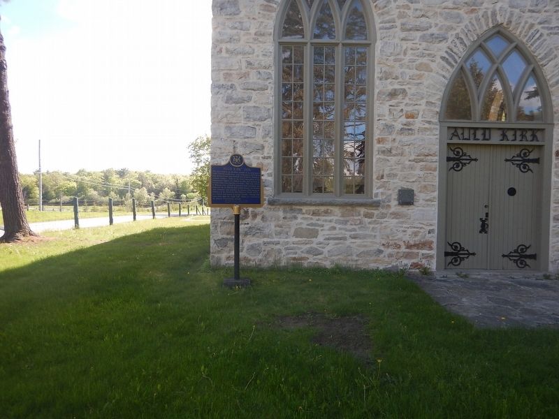
On Wolf Grove Road (County Highway 16) close to Ramsay Concession 8, on the right when traveling west.
This stone church, an attractive example of an early form of Gothic Revival architecture, was constructed in 1835–36 on land obtained from John Mitchell, one of Ramsay Township's earliest settlers. Built by the local congregation of the Established . . . — — Map (db m104031) HM
On County Road 29 0.1 kilometers north of James Naismith Way / Clayton Road, on the right when traveling north.
This is the boyhood home of James Naismith, the inventor of basketball. Born in a house which formerly stood on this lot, he entered McGill University in 1883 where he was active in athletics. In 1890 Naismith graduated in theology from . . . — — Map (db m104107) HM
On Mill Street at Little Bridge Street, on the right when traveling west on Mill Street.
Begun in 1889 and finished in 1891, this building was erected to house postal and customs services. Federal chief architect Thomas Fuller was responsible for the design and Robert Cameron was the contractor. The building was part of a national . . . — — Map (db m104019) HM
On Mill Street 0.1 kilometers west of Little Bridge Street, on the right when traveling west.
The Mississippi River in eastern Ontario is a tributary of the Ottawa River. The upper basin starts in the Mazinaw Lake area and enters the Ottawa River above Chats Falls. Recognizing a need to manage the water flow, Mr. Jim Brown of Carleton Place . . . — — Map (db m104108) HM
On Almonte Street, on the left when traveling north.
Sir William E. Logan and the Geology of Canada
This plaque commemorates the 175th anniversary of
Natural Resources Canada's Geological Survey of Canada
(GSC) and a dramatization of its founder William Logan
visiting the . . . — — Map (db m254510) HM
On Bridge Street (County Highway 16A) at Water Street, on the right when traveling south on Bridge Street.
The sawmill and grist-mill completed here on the Mississippi River in 1823 by Daniel Shipman provided the nucleus around which a community known as Shipman's Mills had developed by 1824. About 1850 two town plots were laid out here - "Victoria" by . . . — — Map (db m104000) HM
On Mill Street at Almonte Street (County Highway 16), on the right when traveling west on Mill Street.
In 1857 James Rosamond built this mill on the Mississippi River, thereby firmly establishing the woollen industry in Almonte. An Irish-born entrepreneur, Rosamond was previously a resident of nearby Carleton Place where, in 1846, he had built one . . . — — Map (db m104009) HM
On Franklin Street at Beckwith Street, on the right when traveling east on Franklin Street.
Originally the site of the Market Square, Memorial Park was created with the dedication of the local cenotaph in 1924. Part of Memorial Park also consists of land (the north-eastern section) donated by the Gillies family as a result of . . . — — Map (db m234330) HM
On Bridge Street at the north bank of the Mississippi River, on the left when traveling north on Bridge Street.
[Stylized bas relief of Roy Brown's epic dogfight with the Red Baron]
[Sculpture of Roy Brown looking skyward with the
Distinguished Service Cross in hand] — — Map (db m234444) HM
On Beckwith Street at Franklin Street, on the right when traveling north on Beckwith Street.
Victor in aerial combat over Baron Manfred von Richthofen, the First World War's leading fighter pilot and German national hero, Arthur Roy Brown was born at Carleton Place. In 1915 he qualified as a civilian pilot and was commissioned . . . — — Map (db m103968) HM
Built between 1895 and 1897 for a cost of $26,000, our Town Hall was designed in the Richardson Romanesque style by Toronto architect George King. It replaced the original Town Hall built in 1872 on Edmund Street. The chateau style . . . — — Map (db m234392) HM
On Mill Street just east of Bridge Street, on the left when traveling east.
Unveiled on May 17, 2019, this pebble mosaic was created by 75 members of the Carleton Place community as a tribute to sexual assault victims.
Made in collaboration with Lanark County Interval House and Red Dress Productions, this monument . . . — — Map (db m234377) HM
On Bridge Street at the Mississippi River, on the right when traveling south on Bridge Street.
Scottish born David Findlay arrived in Canada in 1858 and settled in Perth, Ontario. Finding little opportunity for working at his trade as a moulder, he left two years later for
Carleton Place. Walking the 21 miles with only $30 in . . . — — Map (db m234402) HM
On Flora Street at McRostie Street, on the right when traveling south on Flora Street.
The families of Edmond Morphy and William Moore became in 1819 the first settlers on the site of Carleton Place. About 1822 Hugh Boulton built a mill here on the Mississippi River which provided the nucleus around which a community, known as . . . — — Map (db m103985) HM
On Franklin Street at Beckwith Street, on the right when traveling east on Franklin Street.
On June 8th, 2013, a dedication ceremony was conducted on this site following a three year restoration and expansion project of the cenotaph area. This project was completed through the joint efforts of the Town of Carleton Place, Veterans . . . — — Map (db m234332) HM
On Franklin Street at Beckwith Street, on the right when traveling east on Franklin Street.
CONFLICTS SINCE 1953
1946-1991/Cold War • 1990-1991/Gulf War • 1992-1995/Somali Civil War
1992-1995/Bosnian War • 1998-1999/Kosovo War
1999-2000/East Timor • 2001-2014/Afghanistan War
2003-2011/Iraq War • 2011/Libyan Civil War
OUR . . . — — Map (db m234334) WM
On Bridge Street at Lake Avenue, on the right when traveling west on Bridge Street.
This grand stone hotel at 7 Bridge Street was built on land originally deeded in 1824 to William Morphy, one of Carleton Place's original settlers. It was built by Napoleon Lavalee in 1872, who operated it as a hotel and a . . . — — Map (db m239904) HM
On Bridge Street just west of Albert Street, on the right when traveling west.
The first post office was established in town in 1830. That same year, the name of the community changed from Morphy's Falls to Carlton Place, and then, through a slip in typing, to Carleton Place. By 1890, the growth of the town was . . . — — Map (db m234052) HM
On Bridge Street 0.1 kilometers south of Emily Street, on the left when traveling south.
The settlers who first received land grants within the present area of the Town of Carleton Place were four members of the family of Edmond Morphy and three members of the William Moore family. The Moore family's grant stretched from present-day . . . — — Map (db m234328) HM
On Mill Street just east of Bridge Street, on the left when traveling east.
The Town Hall Square forms the nucleus of the pioneer development along the Mississippi River and rapids. This environmentally important area, near the unique and significant stand of Hackberry Trees, has become the central part of the Town of . . . — — Map (db m234372) HM
On Mill Street just east of Bridge Street, on the left when traveling east.
The Ripple [Steamboat on Mississippi River] 1885
First Nations Harvesting of wild rice
Logging on the Mississippi
Men's War Canoe Team 1905
The Ballygiblin Riots 1824 — — Map (db m234374) HM
On Provincial Highway 15 just north of Church Street, on the left when traveling north.
Born at Coupar-Angus, Scotland, Buchanan graduated in medicine from Edinburgh University. He later became a Presbyterian minister and was called to Upper Canada. He arrived in Beckwith Township in August 1822, to become its first . . . — — Map (db m233987) HM
On Church Street 0.6 kilometers east of Provincial Highway 15, on the left when traveling east.
Beckwith Township, surveyed in 1817, had among its first settlers discharged military personnel and emigrants from the United Kingdom. The Reverend Michael Harris of Perth administered to the Anglicans until a resident clergyman, the . . . — — Map (db m233990) HM
On Church Street 0.4 kilometers east of Provincial Highway 15, on the left when traveling east.
The first road through Beckwith Township was cleared
in 1819 from Richmond to Perth:
This work was done by British soldiers. The road was cut 60 feet wide
and was to connect the military settlements of Richmond and Perth.
It entered . . . — — Map (db m234011) HM
On George Street (County Highway 511) just south of Clarence Street, on the right when traveling north.
Journalist, poet, advocate of western expansion, and an original member of the Canada First movement, Mair was born at Lanark, Upper Canada. A controversial figure during the Red River uprising (1869-1870), he was subsequently a pioneer . . . — — Map (db m272884) HM
On George Street (County Highway 511) just south of Clarence Street, on the right when traveling north.
In August, 1820, a government depot was completed on the site of this community to serve as the centre of a military settlement in the newly-surveyed townships of Lanark, Ramsay, North Sherbrooke and Dalhousie. By the spring of 1821 some 1,500 . . . — — Map (db m272880) HM
On Clarence Street just east of George Street (County Highway 511), on the right when traveling east.
To The Glorious Memory
of the Boys
who Gave Their Lives
In the War 1914 - 1918
Beechum Bates • Benjamin Cardinal • Allie Cardinal • Maxwell McIlquham
Roy McIntyre • Nicholas Penny • John Rothwell • Harry Stafford
William Strang • . . . — — Map (db m272887) WM
On Maberly Elphin Road (County Highway 36) 0.1 kilometers west of Maberly Main Street, on the left when traveling west.
The original peoples of the land on which this park is situated are the Omàmiwininì, members of the Algonquin Anishinaabe family. In the distant past, they settled in the valley of the Kiji Sibi, (Ottawa River), and its tributaries, including the . . . — — Map (db m272873) HM
On Maberly Elphin Road (County Highway 36) 0.1 kilometers west of Maberly Main Street, on the left when traveling west.
In 1869, great grandparents of Canadian poet/songwriter Leonard Cohen chose this burgeoning hamlet for their home, commencing a new life in Canada that would have long-term impact on our young country. Lazarus and Frayda Cohen family were active . . . — — Map (db m272870) HM
Near Ramsay Concession 8 1.7 kilometers north of Clayton Road.
Surgeon, educator and sculptor, McKenzie was born in Lanark County, Ontario. After graduating in medicine at McGill University, he became its Medical Director of Physical Training in 1894. A pioneer in physical education, he served as a surgeon . . . — — Map (db m104096) HM
Near Ramsay Concession 8 1.7 kilometers north of Clayton Road.
This grist-mill was constructed in 1830 by John Baird, a Scottish pioneer. In 1930 it was restored by Robert Tait McKenzie (1867–1938) the prominent Canadian surgeon, physical educator, and sculptor, as his summer home and studio. Born in . . . — — Map (db m104090) HM
On Kinburn Side Road (County Highway 20) at Dark's Side Road, on the right when traveling west on Kinburn Side Road.
Welcome to Pakenham's five-span stone bridge - one of the Seven Wonders of Lanark County.
It was built in 1901 by O'Toole & Keating of Ottawa from locally quarried stone with the largest block weighing five tonnes. This spectacular engineering . . . — — Map (db m272915) HM
On County Highway 29 at Renfrew Street, on the left when traveling south on County Highway 29.
Born in Pakenham, John graduated from high school with first class honours, and began his life-long involvement in community and political organizations at an early age. A full-time farmer, he served in Pakenham as Postmaster, Township Clerk, . . . — — Map (db m272913) HM
On Kinburn Side Road (County Highway 20) at Dark's Side Road, on the right when traveling west on Kinburn Side Road.
The unique five span stone bridge was built in 1901, with a 20-foot wide roadway
to accommodate pedestrians, horses and carts. Decades of wearing use later and to adapt to modern traffic requirements, the bridge required extensive . . . — — Map (db m272958) HM
On County Highway 29 at Renfrew Street, on the left when traveling south on County Highway 29.
Pakenham was a thriving community by the mid 1800s, with a population of over 200 in the village and over 1,200 throughout the township. Ideally located between the fertile agricultural land of the valley and the timber of the . . . — — Map (db m272912) HM
On County Highway 20 at the bridge's west approach, on the right when traveling east on County Highway 20.
This is the only stone bridge of its kind on the North American continent
Length-268 ft. Width 25 ft. Height-22 ft.
Five 40 ft. arches-piers 8 ft. thick
Abutments at each end 18 ft.
Largest stone is 9 ft. long & 2½ feet square
& . . . — — Map (db m272980) HM
On Kinburn Side Road (County Highway 20) at Dark's Side Road, on the right when traveling west on Kinburn Side Road.
Originally constructed in 1901 this bridge is the only stone arch bridge in North America having 5 masonry arches. The bridge was completely restored to its original state during 1984 by the County of Lanark with the co-operation and financial . . . — — Map (db m272961) HM
On County Highway 29 just south of Jeanie Street, on the right when traveling north.
A large frame hall was located on this property where the cenotaph stands. Originally built as the Roman Catholic church, it was moved from MacFarlane Street to this site in 1896 when the present St. Peter Celestine's was built at . . . — — Map (db m272903) HM
On County Highway 29 just south of Jeanie Street, on the right when traveling north.
Pakenham's first village school opened in 1841. The large frame building still standing on the corner of Dalkeith Street and Waba Road was built in the 1850s and once housed both a common (elementary) and a continuation (high) . . . — — Map (db m272901) HM
On County Highway 29 at the Five Span Stone Bridge (County Highway 20), on the right when traveling north on County Highway 29.
With settlers first arriving here in 1823, the river and falls provided all-important resources for development. By 1840, Andrew Dickson, considered to be the father of
Pakenham, had established his family home (the stone building . . . — — Map (db m272951) HM
On Renfrew Street just west of County Highway 29, on the left when traveling west.
Welcome to Pakenham's St. Peter Celestine Church - one of the Seven Wonders of Lanark County.
The cornerstone for this Roman Catholic Church was laid in 1892, and construction by many talented local crafts people continued for nine years. It . . . — — Map (db m272914) HM
On Drummond Street East at Harvey Street, on the right when traveling west on Drummond Street East.
This house was built in 1823 by James Boulton, one of Perth’s first lawyers. Modelled after "The Grange" in Toronto, the house was designed in the Adamesque style, which was popular in Upper Canada during the 1820’s, with overtones of the . . . — — Map (db m207798) HM
On Basin Street at Tay Street, on the right when traveling north on Basin Street.
The Tay Basin is a central depot for water travel on the Tay. In its youth, it aspired to become a major port for shipping and receiving goods, as it was linked to the newly finished Rideau Canal. The Tay's snies, creeks and swamps were . . . — — Map (db m207906) HM
On Basin Street at Tay Street, on the right when traveling north on Basin Street.
Perth merchants regularly used the Tay Canal between 1834 and 1850. Potash, timber and local produce were shipped to Montreal, and dry goods and manufactured articles were imported.
But the canal steadily fell into disrepair as soon . . . — — Map (db m208017) HM
On Basin Street at Tay Street, on the right when traveling north on Basin Street.
In the wilderness of 19th century Upper Canada, transportation was the key to settlement, growth and prosperity. Waterways, modified with locks and canals, were seen as the solution to many transportation problems. A feverish era of . . . — — Map (db m208032) HM
On Mill Street, on the right when traveling south.
Historically, Perth has always boasted a thriving creative community with music, dance and theatre at the core of activities. That tradition continues today with many residents internationally known as award-winning artists, musicians . . . — — Map (db m233963) HM
On Basin Street at Tay Street, on the right when traveling north on Basin Street.
The landscape in the Tay Basin has changed dramatically over the years. It has gone from an early settlers' campground to shipping docks and from residential housing to a market square.
Once called Perth Landing, its docks bustled with . . . — — Map (db m207886) HM
The three fountains in the Tay Basin are known as the International Friendship Fountains. They were installed in 2004, thanks to the Ontario Small Town and Rural
Economic Development Program (OSTAR-RED) and the generosity of the Rotary Club of . . . — — Map (db m207849) HM
On Basin Street at Tay Street, on the right when traveling north on Basin Street.
The British government established the first Military Settlement in Canada in March, 1816 at Perth upon Tay in response to continuing fears of an American invasion
following the War of 1812. A depot was established with a Superintendent's . . . — — Map (db m207948) HM
On Basin Street at Tay Street, on the right when traveling north on Basin Street.
Perth was created in 1816 as part of a grand British defence strategy which included the Rideau Canal and Fort Henry at Kingston. By 1822 Perth had burst into a vibrant frontier town, the new County Seat for the District of Bathurst . . . — — Map (db m208000) HM
On Basin Street at Tay Street, on the right when traveling north on Basin Street.
Enthusiasm for canals in 19th century Canada remained high despite the flurry of railway
construction after 1850. The government continued to maintain canals, including the Rideau Canal, to ensure their competitiveness. This kept alive . . . — — Map (db m208028) HM
On Mill Street just south of Market Street, on the right when traveling south.
Although it is hard to tell at a glance, there are no less than eight bridges connecting Cockburn and Haggart Islands to the mainland in Perth's downtown core - and each bridge has its own personality and history.
Locke's Bridge on . . . — — Map (db m233962) HM
Algonquin/Omàmìwinini People have lived on this river and in this territory for thousands of years. These waterways were elemental to people's seasonal lives, moving into the family's territories in the upper watersheds for the winter and . . . — — Map (db m207879) HM
On Basin Street at Tay Street, on the right when traveling north on Basin Street.
The Tay has seen many tales over the years. Once covered by the salt water of
the Champlain Sea, the banks of the Tay hold the memory of a very different aquatic life from what you see today. The fossils in the bedrock tell the story of a . . . — — Map (db m207937) HM
On Mill Street just south of Market Street, on the right when traveling south.
[Photo captions, counterclockwise from top left, read]
• Spalding & Stewart
• Spalding & Stewart
• McLaren's Distillery
• THE TAY FROM HAGGARTS
• [Trail map and] Legend
The Tay River Trail is an historic pathway and portage . . . — — Map (db m233875) HM
On Drummond Street East at Colbourne Street, on the right when traveling east on Drummond Street East.
Erected by the Lanark County Cheese Producers
in recognition and appreciation of the services of
all those who through legislative educational
commercial or industrial leadership or activity
did lay the foundation and did guide the . . . — — Map (db m207883) HM
On Gore Street East (County Highway 43) at Harvey Street, on the right when traveling east on Gore Street East.
An astute public servant who played a significant role in the development of Western Canada, Morris was born in Perth. In 1861, after establishing a successful law practice in Montreal, he was elected to the legislature as the member . . . — — Map (db m207696) HM
On Basin Street at Gore Street East (County Highway 43), on the right when traveling north on Basin Street.
Before you lies the restored Tay Canal Turning Basin, today part of Parks Canada's Rideau Canal heritage waterway.
The Tay Canal was once the symbol of progress and prosperity to the people of Perth. First operated in 1834, the canal . . . — — Map (db m207782) HM
Killed in Action at
Passchendaele
Nov 4th 1917
Gone But Not Forgotten
Nec Tamen Consumebatur
["Yet it was not consumed" from Exodus 3:2]
[War Medallion]
He Died For Freedom and Honour — — Map (db m233728) WM
On Wilson Street East at Herriot Street, on the right when traveling east on Wilson Street East.
Born at Winston March 27, 1976
Sire: Etretat - Mare: Oekie
Breeder: J. Van Hooydonk
Kalmthout, Belgium
Big Ben's Career Highlights
Did you know...
• Big Ben was Ian Millar's mount for nearly half of Millar's career
Grand Prix . . . — — Map (db m233771) HM
On Drummond Street East at the east bank of the Tay River, on the right when traveling east on Drummond Street East.
This "forest in the making" was planted in 2002 with a variety of ash, oak, pine, walnut, butternut, spruce, dogwood and hackberry. As the trees grow, the understory will continue to evolve from a grass lawn to a forest floor ecosystem.
These . . . — — Map (db m207792) HM
Dedicated to the memory of 400 unmarked indigent
burials contained within this general area.
Most of these people died at the former
House of Industry of Lanark County.
House of Industry Deaths 1903-1935
Richard Adams · Thomas . . . — — Map (db m234461) HM
On Craig Street just south of Gore Street East (County Highway 43), on the left when traveling south.
Here died the victim of the last fatal duel fought in this province,
June 13, 1833. Two law students and former friends, John Wilson and
Robert Lyon, quarrelled over remarks made by the latter concerning a
local school teacher, . . . — — Map (db m233873) HM
On Drummond Street East at Colbourne Street, on the right when traveling east on Drummond Street East.
A prominent Upper Canadian entrepreneur and politician, Cameron was born in Trois-Rivières. He began his business career in Perth, establishing himself as a general merchant and in 1834 co-founding the Bathurst Courier. In 1837 . . . — — Map (db m207786) HM
On Drummond Street East at Colbourne Street, on the right when traveling east on Drummond Street East.
The Mammoth Cheese was more talked about and written about than any other single
exhibit at Chicago's World Fair in 1893. Judged to be near perfection, the cheese garnered 95 points out of a possible score of 100 points, receiving a diploma . . . — — Map (db m207843) HM
On Gore Street East just east of Foster Street, on the left when traveling east.
Built in 1840 of local sandstone, the Matheson House is an outstanding example of early Scottish-Canadian architecture. Its design is imposing, its stonework remarkably fine, and it
occupies a key position in one of the best surviving . . . — — Map (db m233817) HM
On Gore Street East (County Highway 43) at Foster Street, on the left when traveling east on Gore Street East.
[Photo caption reads] Exterior photo of Shaws circa 1940.
This high profile site
was first home to
Roderick Matheson's
harness and saddle
shop in 1818 until
1840 when he
commissioned the
building of this two storey cut stone . . . — — Map (db m233820) HM
On Gore Street East (County Highway 43), on the left when traveling east.
1981 Regional Award of Honour
for the preservation of
Matthews Building, Ontario
—————————————
The heritage character and integrity of this property
are protected by a legal agreement between the
owner and the Ontario Heritage . . . — — Map (db m233867) HM
On Gore Street East (County Highway 43) at Harvey Street, on the right when traveling west on Gore Street East.
The son of Loyalists from the Morrisburg area, Daniel McMartin (1798-1869) established a law practice in Perth in 1823. Well-educated and well-connected, he acquired clients like timber baron Philemon Wright of Hull. McMartin chose a . . . — — Map (db m207667) HM
On Harvey Street at Gore Street East (County Highway 43), on the right when traveling north on Harvey Street.
Begun in 1830 for barrister Daniel McMartin (1798-1869), this imposing house symbolizes the wealth and social aspirations of this member of the Tory elite. Born at Williamsburg of Loyalist stock, McMartin attended John Strachan's . . . — — Map (db m207662) HM
On Gore Street East (County Highway 43) at Tay Street, on the right when traveling west on Gore Street East.
The present townships of Bathhurst, Beckwith and Drummond were settled under the jurisdiction of the Quarter Master General's Department. Scottish emigrants, quartered in barracks at Brockville during the winter of 1815-16, and soldiers . . . — — Map (db m207754) HM
On Gore Street East (County Highway 43) at Market Square, on the left when traveling west on Gore Street East.
Perth's stately town hall is an enduring expression of the vitality and importance of local governments in the 19th century. Erected in 1863-1864, shortly after the town's
incorporation, it recalls an era when such buildings served as . . . — — Map (db m207771) HM
On North Street (County Highway 10) at Drummond Street West, on the right when traveling north on North Street.
One of the most influential Presbyterian clergymen in Upper Canada, Bell was born in Airdrie, Scotland. In 1808, he entered a Congregational academy in London to train for the ministry and, after completing his studies in Scotland and . . . — — Map (db m233976) HM
On Wilson Street East at Church Street, on the right when traveling east on Wilson Street East.
Roman Catholics began to settle in the Perth area from 1816 onwards. They were served by visiting missionary priests until 1823 when Father John Macdonald became the first resident pastor of the new parish which embraced most of the present-day . . . — — Map (db m233870) HM
On Mill Street just south of Market Street, on the right when traveling south.
The citizens of Perth are very fortunate to have such a pristine green space in the heart of the downtown core. This beautiful parkland straddles two islands with the Tay River on one side and the Little Tay on the other. It is . . . — — Map (db m233947) HM
On Gore Street East (County Highway 43) just east of Foster Street, on the right when traveling east.
Colonel Balderson commissioned this building at the cost of $150,000 in 1914. Touted as the finest theatre between Toronto and Montreal, the new 1000-seat theatre with its opulent opera house décor and grand central lobby opened its doors in . . . — — Map (db m233811) HM
On Basin Street at Tay Street, on the right when traveling north on Basin Street.
The second Tay Canal, like its predecessor, was never the large-scale success anticipated by its supporters. While freight and passenger steamers were a common sight, recreation became the focus for the canal by the 1920s. Today there . . . — — Map (db m208031) HM
On Basin Street at Tay Street, on the right when traveling north on Basin Street.
William Morris, a fiery businessman and local politician, was the driving force behind the creation of the first Tay Canal. When the government refused petitions to construct the canal, the people of Perth, led b[y] Morris, decided . . . — — Map (db m208004) HM
On Gore Street East (County Highway 43) at Basin Street, on the right when traveling west on Gore Street East.
The Old Perth Post Office
The buildings that were previously built here were torn down in 1913, after the government bought a vacant lot from John A. Stewart and three adjacent buildings on this corner. The property sat unused for twenty . . . — — Map (db m207769) HM
On Gore Street East at Herriot Street, on the left when traveling east on Gore Street East.
[Photo caption reads] Early photo of interior of Perth Courier.
This two-and-half-storey stone building is part of what became known as the Kellock Block which was built by John Ellis for Roderick Matheson in 1848. It was host to many . . . — — Map (db m233773) HM
On Gore Street East (County Highway 43) at Market Street, on the left when traveling west on Gore Street East.
For outstanding stewardship of the built heritage
———————————————————————
Attestation d'excellence en gestion du patrimoine bâti — — Map (db m207776) HM