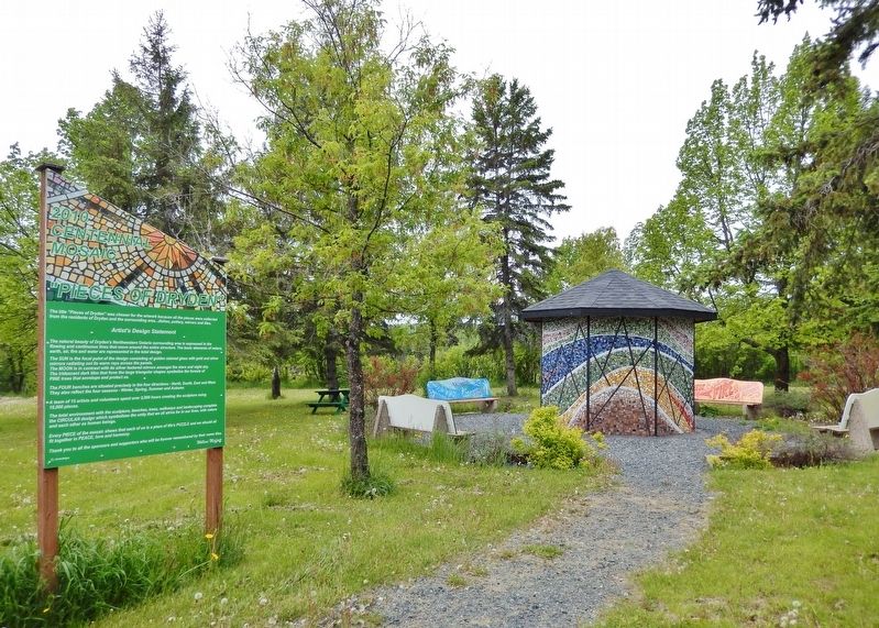
The title "Pieces of Dryden" was chosen for the artwork because all the pieces were collected from the residents of Dryden and the surrounding area… dishes, pottery, mirrors and tiles. Artist's Design Statement The natural beauty of . . . — — Map (db m243233) HM
In 1923, a garage was built here and an automobile sales and service was operated by "Dryden District Motors", "Dryden Motors", and "Dryden Service" respectively. Vernon Pronger rebuilt the building in 1938, and operated "Vernon's Grocery" here for . . . — — Map (db m243107) HM
Born in Reston, Manitoba Sept. 20, 1920 and brought up in Treherne, Manitoba, Grant had a happy, busy childhood. When WWII started, Grant volunteered with the Air Force, serving in North Africa and England. He was on his way to the Pacific when the . . . — — Map (db m243231) HM
According to legend, the Honourable John Dryden, Ontario Minister of Agriculture, got off the train at Barclay Tank to stretch his legs on a trip to the west in 1893. He was impressed with the clover growing along the embankment, and as a result . . . — — Map (db m242999) HM
Alan Durance left behind a legacy of accomplishments the likes of which most people only dream. It all began in 1919 at age 17 when he arrived from England with his parents and siblings and settled on a homestead farm two miles north of Dryden. . . . — — Map (db m243095) HM
Alex Wilson was a visionary and a man of many talents and accomplishments. He came to Canada with his Scottish parents at age eight. With a grade nine formal education, he began a life-long period of learning in the real world of the world's worst . . . — — Map (db m243269) HM
The west shore of the river is about where nature made it. There was a waterfall where the dam and Duke Street Bridge are now, and an island at the east end of the present bridge. A second channel, also with a waterfall about where you are . . . — — Map (db m242997) HM
Before World War II, most of the wood supply for the mill as well as the several saw mills which operated in Dryden was delivered by water. The wood was cut generally in the winter around the hundreds of miles of shore line of Lake Wabigoon and its . . . — — Map (db m242994) HM
Dryden has been a center of the forest industry for over a century due to the availability of timber, its location on the Canadian Pacific Railroad and, before the existence of the power grid, the potential for power generation by the Wabigoon . . . — — Map (db m243085) HM
In 1940, at the age of 21 years, Russell left Dryden to escape the great depression, and to join the Royal Canadian Regiment at London, Ontario. In 1943 he left the peaceful hills of England to land in Sicily as part of the British Army. When . . . — — Map (db m243258) HM
Farmer, bush camp foreman, tugboat operator, retail lumberman, husband and father, fisherman, hunter, town councillor, mayor. George Rowat was part of a generation who started life in an era of great potential and who worked hard to build their . . . — — Map (db m243094) HM
About 1885 gold was discovered at Goldrock on the northern tip of Upper Manitou Lake about 30 miles southeast of here. A townsite was laid out in 1898 which grew to a town of 500 by its peak in 1908. At that time there were 5 gold mines operating . . . — — Map (db m243000) HM
Built in 1897 by J. S. McFadyenMr. McFadyen built several of the town’s early buildings including the first jail & council chamber in 1904. — — Map (db m243242) HM
In 1949 Norman McAuley opened Dryden's first law office. Choosing Dryden was a geographical compromise as Norman grew up on a farm outside of Orangeville, Ontario and Valerie had spent her childhood in Saskatchewan. Norman continued to practice law . . . — — Map (db m243292) HM
In 1894, The Honourable John Dryden, Minister of Agriculture, travelled to Northwestern Ontario to explore the commercial possibilities of the region. He found clover growing in abundance and, at that time, there was a demand for clover on the . . . — — Map (db m243054) HM
In the early 1900’s the best and strongest wrapping paper was made from Jack Pine using the Kraft process. The process used then required quantities of soap stone, and there are a number of soap stone mines in the Dryden area. The principal forest . . . — — Map (db m242993) HM
The area just north of this point was originally an island and the east branch of the river. When the earth dam forming the base of Duke Street was built, the east branch of the river became a bay which was used for swimming. Later a small Hall . . . — — Map (db m242995) HM
[left side] Opened in the Fall of 2009, the naming of this bridge after Mr. Roy Wilson recognizes his many contributions to City Revitalization. This 34 meter suspension bridge was built with generous support from the Province of Ontario . . . — — Map (db m243089) HM
For 20 years Dryden turned its back on its waterfront, and the river no longer played a central role in the lives of the town. The wood disappeared from the river, and the paper mill retreated from the waters edge. The dilapidated boathouses . . . — — Map (db m242996) HM
Construction of the Canadian Pacific Railway was completed through the Dryden area in 1882. The railroad was constructed through virgin wilderness in this area, mostly mature forest which was readily ignited by sparks from the wood burning . . . — — Map (db m242998) HM
This building was built in 1911 by postmistress, Mrs. Ida Smith. With Ida's death in 1921, her daughter Aldra became owner and postmistress. In 1926, Mr. John Harris became owner and postmaster. The post office was moved in 1939. Mr. & Mrs. . . . — — Map (db m243297) HM
Dedicated in memory of William Jennings (Bill) Silver A papermaker of forty-eight years and husband of Edna Lillian Silver (nee Neely), Bill was a gentle and upright man who loved and supported his family and his community. The Silver family was . . . — — Map (db m243293) HM
This aircraft was built from parts of three planes and erected here on false floats in 1995. The original plane — CA-222-3NM — was built in 1952 and assigned to the Royal Canadian Air Force. While the Beech 18 was never intended to be for the . . . — — Map (db m243381) HM
"The Forest Fire Prevention Act" of 1917 determined fire protection procedures for Ontario. The Act divided the province into separate districts, each under the complete authority of a District Forester. Included under his jurisdiction were the . . . — — Map (db m243299) HM
On the afternoon of July 8th, 2018 a large wildland fire was detected by an aircraft that was enroute to another fire near the Temiskaming Shores, Lady Evelyn-Smoothwater Provincial Park. That fire turned out to be North Bay Fire #72. The . . . — — Map (db m243392) HM
The Mary Berglund Community Health Centre is named for the registered nurse who maintained health services in Ignace for over thirty years from the 1940's to 1970's. Mary found herself acting as a general practitioner — not by choice, but by . . . — — Map (db m243300) HM
The Towerman's job was a lonely one. He could not leave the tower without notifying the Chief Ranger and was required to report in at set times. During hot, dry weather, days off were unknown. A rainy spell might offer a respite from tower duties. . . . — — Map (db m243298) HM
Logging operations began locally in 1879 when demand for ties and lumber came with the construction of the Canadian Pacific Railway in the area. As many as seven mills operated along the Rat Portage-Keewatin shore lines at one time employing 400 to . . . — — Map (db m245199) HM
Commemorating the lifelong services to this town and district of Dr. W. J. Gunne 1859-1950 As C.P.R. Medical Officer and General Practitioner his splendid life and untiring work were generously devoted to humanity and progress in our . . . — — Map (db m245385) HM
Twenty year old Jacques de Noyon is believed to have been the first white man to reach the Lake of the Woods. The year — 1688. In 1717 De la Noue took the same route, up the Kaministiquia River, following a chain of lakes and streams to Rainy . . . — — Map (db m245138) HM
Created by Dan Sawatzky of Chemainus, British Columbia, the mural is titled after a rowing term, “Riding the Flame”, which means the Herculean effort made by the rowers to propel their boats over the finish line in a competition. Featured in the . . . — — Map (db m245303) HM
This mural was one of the first to be sponsored by a local businessman, the owner of this hotel. It shows a gentleman’s bar at the turn of the century, with woodcarving, elaborate glassware & formally dressed bartenders. Two players enjoy a card . . . — — Map (db m245377) HM
Reception of the Marquis of Lorne, August 5, 1881 at the Lake of the Woods, Rat Portage Most of the 500-plus inhabitants of Rat Portage, including older Indians and French-Canadian voyageurs, waited along the waterfront behind today's Library, . . . — — Map (db m245165) HM
On July 1, 1936, Premier Mitchell F. Hepburn opened the highway between Kenora and Fort Frances and named it the "HEENAN HIGHWAY" in recognition of the public service given by The Honourable Peter Heenan to the Kenora-Rainy River District. Born in . . . — — Map (db m215896) HM
World Of Sport — Kenora Thistles Win Stanley Cup The story roots in the early 1900's boom + bust expanding Northern America resource economy. Hockey was serious entertainment; fast and furious. Names like Roxy Beaudro, Bill . . . — — Map (db m245000) HM
This was early frontier Kenora/Keewatin, and was named by the Ojibway people for the many muskrats inhabiting these waters. Venturing into this area were a number of fur traders employed by the Northwest Company and the Hudson’s Bay Company. They . . . — — Map (db m244996) HM
On Old Fort Island a half mile north of here, the Hudson's Bay Company erected a stockaded fur trading post about 1836. This was the first known European structure within present Kenora. In 1861 the post was moved to the mainland, where it formed . . . — — Map (db m106495) HM
Rat Portage (now Kenora) Rowing Club was founded in 1890. Its headquarters was built in 1892 on the current site of the Bank of Nova Scotia. Two of its most prominent members are portrayed here against the setting of the Rowing Club and . . . — — Map (db m245320) HM
Born at St. Sulpice, Quebec, and ordained in 1849, Father Lacombe took up mission work at Fort Edmonton in 1852. The following year he founded Ste. Anne, first of several Oblate missions he established in what is now Alberta. He won the confidence . . . — — Map (db m106498) HM
Created by Mike Svob of Coquitlam, British Columbia, the mural depicts the symbol of Canadian unification after confederation. The Canadian Pacific Railroad which was called “The National Dream” enabled all Canadians to travel from coast to coast . . . — — Map (db m245334) HM
In September, 1883 an event unique in Canadian political history occurred in Rat Portage. The origin of the story took place thirteen years earlier when both Ontario and Manitoba claimed Rat Portage as part of their territory. Manitoba claimed all . . . — — Map (db m244999) HM
The full name given in the charter is: “The Governor and Company of Adventurers of England, Trading into Hudson Bay”. The charter, granted by King Charles on May 2nd, 1670, gave the company “The Whole Trade of All Those Seas, Streights, and Bays, . . . — — Map (db m244997) HM
Who Was James McMillan?The namesake of the James McMillan tug boat — Mr. James A. McMillan — was a popular logging superintendent with the Ontario-Minnesota Pulp and Paper Company who died unexpectedly in 1942. McMillan was well . . . — — Map (db m245200) HM
Painted by Frank Lewis of Victoria, British Columbia, the painting features the parade held in Rat Portage, (Kenora) in 1897 to commemorate Queen Victoria’s 60th year on the throne. The Rat Portage Bicycle Club would have come down to watch the . . . — — Map (db m244995) HM
In January 1907, a hockey team from Kenora, comprising E. Giroux (goal), A.H. Ross (point), S.I. Griffis (cover point), T. Hooper (rover), W. McGimsie (centre), R. Beaudro (right wing) and T. Phillips (captain and left wing), defeated the Montreal . . . — — Map (db m199978) HM
Created by Joyce Kamikura of Richmond, British Columbia, the painting features one of the major boat manufacturing companies on the Lake of the Woods and was a landmark on the Kenora waterfront until the late 1960’s. The Clipper was powered by a . . . — — Map (db m245233) HM
In August, 1870, a force of British regulars and Canadian militia comprising some 1,200 men commanded by Colonel Garnet Wolseley, arrived in this area en route to the Red River to establish Canadian authority within the present province of . . . — — Map (db m106494) HM
Main Street, Rat Portage in 1870 was little more than a collection of buildings on the edge of the Lake. Frank Gardner's business establishment is clearly identified; a pioneer who was active for a further 65 years. Lower photo, taken in 1880 . . . — — Map (db m245198) HM
By Water Since Explorer Days By Rail Since 1882 By Road Since 1932 The Keenora: Built in Kenora in 1897, it was the largest steamer ever to operate on Lake of the Woods. It was 128 feet long with a beam of 28 feet. It’s 22 staterooms could . . . — — Map (db m244998) HM
Painted by Alan Wylie of Fort Langley, British Columbia, the mural is a depiction of fifteen different outdoor activities which were and are a part of the leisure life of The Lake of the Woods area. Although some of the sports are no longer . . . — — Map (db m245383) HM
In the 1870s, Canada needed a reliable all-Canadian transportation route between Lake Superior and the western prairie territories it acquired in 1869. After promising a rail connection to British Columbia, the federal government started to build a . . . — — Map (db m106540) HM
John Fowler (1812-1900) was a railway contractor from Yorkshire who emigrated to southern Ontario where he built the Grafton-Cobourg section of the Grand Trunk Railway, leased the Port Hope, Lindsay & Beaverton Railway, and acquired the charter for . . . — — Map (db m106541) HM
[English]Official twinning of the Township of Atikokan and the Town of Schefferville May 15, 1968 Welcome to the delegates from Schefferville [Français]Jumelage officiel de la ville . . . — — Map (db m309995) HM
As early as 1897 the presence of hematite boulders on the shores of Steep Rock Lake led geologists to suggest that beneath its waters lay a substantial iron ore body. It was not, however, until 1938 that a drill set up on the ice by Julian Cross of . . . — — Map (db m261099) HM
Erected to the Honored
Memory of
the men from the
municipality
of Chapple
who gave their lives
in the Great War
1914- 1918
Pte F. Stafford 5th Btn ·
H. Shaw ·
R. Wensley 44 ·
J.W. Foy ·
A.W. Hubbard 28 ·
E.J. . . . — — Map (db m203545) WM
In 1869, after the Louis Riel uprising of the breed, the Calders migrated east from the Red River settlement in Manitoba. Their heritage was the mixed blood of Orkney men and Indian maidens. As employees of the Hudson’s Bay Trading Company, William . . . — — Map (db m203492) HM
Two Nations Share Common History Northwestern Ontario and Northeastern Minnesota share the waters of Rainy Lake and Rainy River. The sister communities of Fort Frances and International Falls also share a common history that, for many years, . . . — — Map (db m261996) HM
[English] In 1970, Dianna Boileau (c. 1930s-2014) became the first Canadian to receive gender-affirming surgery. The catalyst for Dianna’s transition was Dr. Harold Challis, a British physician at La Verendrye . . . — — Map (db m261683) HM
The Montreal Fur Trade (1780-1821) Based in Montreal, the fur trade route followed the St. Lawrence-Great Lakes route west. The North West Company established headquarters on Lake Superior, first at the Grand Portage and later at Fort William . . . — — Map (db m309899) HM
The ‘Frances’ in the Fort Traveling on her honeymoon with her husband Sir George Simpson, Governor of the Hudson Bay Company, Frances Simpson describes the fort in her diary, 1830; “The rain fell in torrents all night, and until 9 A.M. . . . — — Map (db m309949) HM
John Robert Nicholson Pither Born in Montreal, J. R. N. Pither came to the country in a birch bark canoe joining the Hudson's Bay Company in 1846. While in charge of Fort Frances between 1853 and 1864, he lived on a point of land where the . . . — — Map (db m309994) HM
Community Roots in Fur Trade History The Calder Clan boasts a heritage of mixed blood of Orkney men and First Nations women — the Métis. As employees of the Hudson’s Bay Company, the ancestors of many community members served as traders, . . . — — Map (db m309897) HM
Fishing below the falls has always been a popular past-time. Oldtimers atest that the old bamboo pole, a staple in all hardware stores, a piece of linen line, a hook and a minnow produced lovely catches of Walleye. The first nations had long . . . — — Map (db m261992) HM
Seeing the Trees in the Forest The Crossroute Forest, managed by the pulp and paper company for the Crown, covers 1,338,415 hectares (3,221,471 acres) — 68 per cent productive forestland. Forest management activities include long-term . . . — — Map (db m309799) HM
Constructed 1875-1878, during Alexander Mackenzie's administration, as part of a larger project intended to improve communication with the West, the Fort Frances Canal provided unbroken communication between Rainy Lake and Lake of the Woods. In . . . — — Map (db m261797) HM
Erected on or near this site some time between 1775 and 1787 by the North West Company, and abandoned in 1821 at the union with the Hudson’s Bay Company. The establishment included “Athabaska House”, the depot where, owing to the distances to be . . . — — Map (db m309800) HM
[English] The first post on Rainy Lake was Fort Tekamanigan, built by Robutel de La Noue in 1717, but soon abandoned, probably because of the Sioux hostility. In 1731 the Sieur de la Jemeraye, La Vérendrye's nephew . . . — — Map (db m261700) HM
The 33 metre Tower (100 foot) was originally constructed at Pal Lake, near Atikokan, Ontario, as part of the Early Radar Detection system of defense established during the Cold War. It was part of the PineTree Line, a series of radar stations . . . — — Map (db m262093) HM
Pathfinders Maps David Thompson, an English Canadian fur trader, surveyor, and map-maker entered an apprenticeship in 1784 with the Hudson's Bay Company and later joined the North West Company. Thompson surveyed much of the Canada-U.S. boundary . . . — — Map (db m261993) HM
[English] Jacques de Noyon was the first white man to explore this region. Born in Trois-Rivieres. Noyon worked in the fur trade as a coureur de bois. In 1688 he led an expedition beyond Lake Superior into territory . . . — — Map (db m261686) HM
The upper Rainy River has been the centre of activity for centuries. The waterway was traveled by the First Nations and later the fur traders traveled the route to reach trading posts located on the lower river. Ship builders, docks and . . . — — Map (db m262226) HM
[English] The Hudson's Bay Company established Lac La Pluie House on this site to compete for furs with the North West Company's Fort Lac La Pluie. After the two companies merged in 1821, only Lac La Pluie House . . . — — Map (db m261687) HM
Lady Frances Ramsay Simpson, as a bride of the Governor of the Hudson’s Bay Company. Sir George Simpson visited the Hudson’s Bay Company Post here on June 1, 1830. In September 25, 1830, the post was renamed “Fort Frances” in her honour. — — Map (db m262100) HM
In October 1984, while constructing a parking lot, the Boise Cascade Paper Company unearthed the remains of men and women from the old cemetery of the Fort Frances Hudson’s Bay Company Post (1814-1870). In 1998, the men and women were again laid to . . . — — Map (db m261997) HM
The Voyageur's Highway The waterway through the Rainy River Region was an important part of the 3,000 mile canoe route from Montreal to the Athabaska country. The geography of the region created a navigable chain of rivers and lakes — a . . . — — Map (db m309863) HM
Paddles and Canoes The development of the fur trade was based on the ability to transport the required goods and furs along the numerous waterways during the short ice-free season. The Canoe, a portable watercraft adapted to interrupted . . . — — Map (db m309876) HM
Castor Gras The best furs were taken in the winter when the beaver were at their prime “…a ‘castor gras d'hiver’, a worn pelt, with guard hairs worn off was most in demand.” The symbol of the Beaver The Beaver is the national . . . — — Map (db m309887) HM
Prior to 1900 wealthy business men had begun to arrive to take excursions through the area for relaxation, fishing, and hunting. By the early 1900's steam boats for travel were prevalent on the upper Rainy River and Rainy Lake. Seeing the . . . — — Map (db m261995) HM
Born in Montreal, Pither joined the Hudson’s Bay Company in 1846. While in charge at Ft. Frances, 1853-56 and 1858-64, he lived in this vicinity (now Pither’s Point). On his retirement from the company in 1869, he served as Indian Agent at Fort . . . — — Map (db m203422) HM
Pierre Gaultier de Varennes, Sieur de La Vérendrye, was born at Trois Rivières and saw military service in North America and Europe before entering the fur trade. While stationed at Lake Nipigon in 1727 he heard stories of the “Western Sea” which . . . — — Map (db m203413) HM
English Fur Traders ‘A Company of Adventurers’ Organized as an imperial trading company, the Bay men were noted for being sober, persistent, cautious and inflexible in the face of competition. The London-based Hudson's Bay Company (HBC) stayed . . . — — Map (db m309885) HM
The first 150 recruits and officers of the North-West mounted Police passed through Fort Frances in October, 1873. They travelled by foot, birch-bark canoe, rowboats, and by open barges towed by steam tugs along the Dawson Route, from . . . — — Map (db m203384) HM
In 1942, the Shevlin Clarke Sawmill was moved, leaving the Shevlin Wood Yard in its place. The available land north of “Shevlin Yard” was sold for homes, schools, government and recreational facilities. The full capacity of Shevlin Yard is 75,000 . . . — — Map (db m309798) HM
In 1912, the Shevlin Clarke Company located their large twin milling facilities at the site of the Reid Sawmill. A major employer in the community, the company took advantage of the vast timber resources and waterway provided by the upper Rainy . . . — — Map (db m262089) HM
This two-mile portage around rapids in the nearby French River was among the most difficult on the Kaministiquia canoe route to the west, first recorded in 1688 by Jacques de Noyon and later used extensively by French and British fur traders. After . . . — — Map (db m261100) HM
The Great Fire Of 1910 started on October 4, 1910 in Williams, Minnesota and spread quickly throughout many Townships. On October 7, 1910 the fire reached Baudette, Minnesota. At this time the railroad and Rainy River citizens used railway . . . — — Map (db m254935) HM
On July 30, 1960 the International Bridge was officially opened between Rainy River, ON and Baudette, MN. Before the creation of the bridge, citizens used a ferry to travel between the two communities. Crossing was a slow process because the . . . — — Map (db m254941) HM
The 4008 steam locomotive was used to haul freight from Rainy River in the 1950's. The 4008 was donated to the Rainy River and District Chamber of Commerce on July 30, 1960 by R.J. McMillan, V.P. of the C.N.R. The original site location for the . . . — — Map (db m254921) HM
The dedication of this flag is in commemoration of those who served and paid the supreme sacrifice in World War I 1914-1918 World War II 1939-1945 Korea 1950-1953 We will remember them. Lest we forget Dedicated November . . . — — Map (db m254948) WM
Incorporated in 1899 under the leading railway promoters Sir William Mackenzie and Sir Donald Mann, the Canadian Northern undertook construction of a line from Winnipeg to Port Arthur. Avoiding Lake of the Woods, the rail line left Manitoba at . . . — — Map (db m254914) HM
In 1849 two priests of the Society of Jesus, Father Jean-Pierre Choné and Father Nicholas Frémiot, established the Mission of the Immaculate Conception on the Kaministiquia River. From there the Jesuits travelled the north shore of Lake Superior on . . . — — Map (db m199599) HM
[English] The mouth of the Pic River has been a center of native trade and settlement for thousands of years. It was a strategic location in the region's water transportation network because it offered access to . . . — — Map (db m255197) HM
This chain of rivers, lakes and portages linking the St. Lawrence system with the waterways of the prairies had been known to the Indians for centuries when Jacques de Noyon first travelled it in 1688. After 1800, when the boundary settlement had . . . — — Map (db m106543) HM
This portage around Kakabeka Falls formed a link in the historic Kaministiquia canoe route connecting Lake Superior with Lake of the Woods and the West. First recorded in 1688 by the French explorer Jacques de Noyon, it was later abandoned in . . . — — Map (db m106547) HM
[top marker]Erected by the Corporation of the Township of Oliver in permanent commemoration of the Centennial of Confederation in Canada in 1967. Construction was made possible through the co-operation of the Province of . . . — — Map (db m255499) HM
The Oliver Agricultural Society was formed in 1890 and held the first Murillo Fair in October 1891. The first executive was Robert McKenzie — President, Owen Duross — Secretary/Treasurer. Our Agricultural Fair has been held on this location for 100 . . . — — Map (db m255497) HM
211 entries matched your criteria. The first 100 are listed above. Next 100 ⊳